Showing 113053 items
matching road
-
 Whitehorse Historical Society Inc.
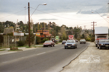
Newspaper - Article, 5 Longland Road, Heatherdale, 22/02/1984
Article in Nunawading Gazette re sale of 100 year old home at 5 Longland Road, Heatherdale. Double brick Victorian on bluestone foundations. Originally land was owned by Mr Witt who later became an M.P., later a master butcher. Mr Purches built the bluestone foundations. It was planned to have a village nearby to be called New Brunswick between Emery's Hill (now Mitcham) and what is now Ringwood. The only evidence of the once planned village is the existence of Brunswick Road nearby.longland road, mitcham, witt, william, purches (mr), brunswick road, mitcham, heatherdale, mitcham, emery's hill, real estate, auctions -
 Linton and District Historical Society Inc
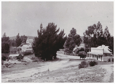
Photograph, Murrell's Victoria Hotel and Edinburgh Mine, Skipton Road, Linton
Two copies - original sepia photograph, and restored black and white copy, showing road coming in to Linton from Skipton, Murrell's Hotel on RHS, Edinburgh Mine works on LHS. Also mounted photograph.On back of original photograph: "Esther Cluff".linton township, murrell's victoria hotel, edinburgh mine -
 Eltham District Historical Society Inc
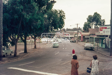
Photograph, Looking north along Main Road at Dudley Street, Eltham, c.February 1968, 1968
Immediately prior to duplication of Main Road35mm Colour positive transparency Mount - Agfacolor Service (Blue stepped)arthur street, dudley street, duplication, eltham, main road, shopping centre -
 Eltham District Historical Society Inc
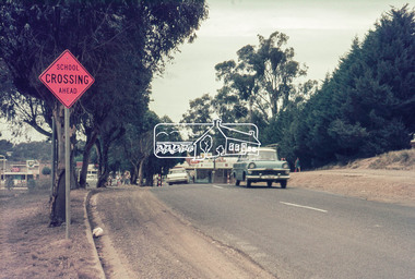
Photograph, Main Road, Eltham near Dudley Street, c.February 1968, 1968
Immediately prior to duplication of Main Road35mm Colour positive transparency Mount - Agfacolor Service (Blue stepped)bp service station, duplication, eltham, main road -
 Eltham District Historical Society Inc
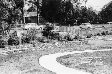
Photograph, War Memorial Garden, Main Road, Eltham, February 1968, Feb 1968
Shows the ramp leading into the gardens from Main Road which lead to the Children's Library and Pre-school buildings. Shows part of the Catholic School buildings across Main Road at Dudley Street intersection.In February 1968 an unknown person took a series of photos from the Eltham Hotel at Pitt Street heading north along Main Road through the shopping centre to just north of Elsa Court covering the length of the section of Main Road which was duplicated shortly thereafter. Shows the condition and environment of the streesscape of Main Road, Eltham immediately prior to the duplication between Pitt Street and Elsa Court through the shopping centre. Also shows a number of shops and businesses that operated at that time.Black and white photographduplication, eltham, main road, shire of eltham war memorial, pre-school, children's library, our ladys church -
 Ringwood and District Historical Society
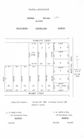
Document, Auction Flyer - Hill's Estate, Wantirna Road, Ringwood - 1960
Typewritten details of Land Auction, 14th May, 1960, with map showing ten allotments in area bounded by Yarmouth Street, Wantirna Road and Walmer Street. Terms £100 Deposit. Residue £30 qrt including interest 6-1/2% Balance 5 years. (Agents) - A.T. Miles & Son, 175 Whitehorse Road, Ringwood WU.6215. C.E. Carter & Son, 126 Whitehorse Road, Ringwood WU.6024, WU.6830. -
 Warrnambool and District Historical Society Inc.
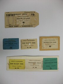
Document - Tickets, Toll road, 1866-1869
In 1866, in an effort to maintain the main roads of the region it was decided to establish toll roads on the Belfast, Woodford Purnim and Allansford roads. Gates were erected and the leases were disposed of by auction. In 1867 the Woodford tollhouse was destroyed by fire suspected to be deliberate. The tolls were removed three years later after much opposition. These tickets are a physical link to one of the earliest attempts to introduce a toll road in the district. Seven toll road tickets five mounted on card. Light paper. Six are for the Main Belfast Road and one for the Woodford road. There are various prices ranging from sixpence to three shillings. Four are cream in colour, one each of blue, yellow and green. They are accompanied by a small newspaper cutting which relates the discovery of one such ticket and the situation of the Belfast tollhouses which were later relocated to 94 and 96 Henna Street near the Alderdice brass foundry.Shire of Warrnambool, Fairfax & Laurie Printers. tollgate, tollgate tickets, woodford toll tickets, shire of warrnambool -
 Eltham District Historical Society Inc
Photograph, Looking east across Main Road from just north of intersection with Diamond Street, Eltham, February 1968, Feb 1968
The watercourse passes under the road and railway at this point. Significant flash flooding occurred along this water course on Christmas Day 2011 causing significant damage to the railway line and road and flooding of Judge Book Village. In February 1968 an unknown person took a series of photos from the Eltham Hotel at Pitt Street heading north along Main Road through the shopping centre to just north of Elsa Court covering the length of the section of Main Road which was duplicated shortly thereafter. Shows the condition and environment of the streesscape of Main Road, Eltham immediately prior to the duplication between Pitt Street and Elsa Court through the shopping centre. Also shows a number of shops and businesses that operated at that time.Black and white photographduplication, eltham, main road, diamond street, bible street reserve, watercourse, drainage -
![Map, [Plan for road to give J. Allan access to permanent water at Coimadai] circa 1870s](/media/collectors/5e461d8021ea67224c82f2a1/items/67735190d671e67dd573a84c/item-media/6773533dd671e67dd573cd90/item-fit-380x285.jpg) Bacchus Marsh & District Historical Society
Bacchus Marsh & District Historical SocietyMap, [Plan for road to give J. Allan access to permanent water at Coimadai] circa 1870s
The date of this map or plan is uncertain but it appears to be from the early to mid 1870s. One of the landholders identified on the plan, James Allan of Coimadai died suddenly on the 9th July, 1874 (see Bacchus Marsh Express, 11 July, 1874, page. 3). There are mentions of an Allans Road at Coimadai in the Bacchus Marsh Express between 1887 and 1942.Single page map showing an excision of land belonging to Charles Ross which was selected to construct a road to give another landholder, J. Allan access to permanent water. Scale 1 chain to 1 inch. Part of a set of maps which are pasted into a bound volume containing 76 maps or plans in total. High resolution digital image stored on BMDHS computer network. Plan showing Excisions from Ross's selection and 1 chain road thro' the said selection in Coimadai to give J. Allan access to permanent water. Alistair ?? Shire Eng? 6?/5/7?coimadai victoria maps, coimadai roads and streets -
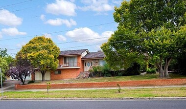
 Glen Eira Historical Society
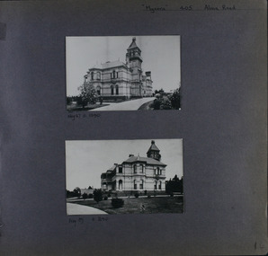
Album - Album page, Myoora, 405 Alma Road, Circa 1972
This photograph is part of the Caulfield Historical Album 1972. This album was created in approximately 1972 as part of a project by the Caulfield Historical Society to assist in identifying buildings worthy of preservation. The album is related to a Survey the Caulfield Historical Society developed in collaboration with the National Trust of Australia (Victoria) and Caulfield City Council to identify historic buildings within the City of Caulfield that warranted the protection of a National Trust Classification. Principal photographer thought to be Trevor Hart, member of Caulfield Historical Society. Most photographs were taken between 1966-1972 with a small number of photographs being older and from unknown sources. All photographs are black and white except where stated, with 386 photographs over 198 pages.Victorian Heritage Register (VHR) Number H0490 From the Victorian Heritage Register Database - Citation for Myoora https://vhd.heritagecouncil.vic.gov.au/places/275 (as at 6/10/2020) Myoora, 405 Alma Road, North Caulfield, was designed by Reed, Henderson & Smart and can be attributed to Anketell Henderson. It was built in 1886 and 1887 for Thomas Christian, who had founded the fabled gold mine, the Day Dawn at Charters Towers. He never occupied the house although his widow lived there for some time. The house was subdivided into three and later six flats. Myoora was one of many large mansions on broad acres with gardens in Caulfield. Perhaps the grandest was Labassa. The mansions date from the 1850s through to the late 1890s. The siting of Myoora on a ridge influenced its planning and composition. A central hall and corridor along the ridge is entered from the centre of the more formal north facade. The entrance is marked by an elaborately detailed tower. A stair turret provides a second accent. The western end of the building is completed by a massively detailed chimney as the service wing. The south facade enjoyed an outlook to port phillip from a two-storey cast iron verandah. Bay windows, chimneys, the tower and the turret and minor details are brought together in a sophisticated asymmetrical composition. This is reflected in the planning. The asymmetry of Myoora pivoting on the tower is the most notable feature of the building. The walls are built of cement rendered brick. The cement render has not been painted. The roof is slate. The balconies and verandah are cast iron. The footings and cellar are bluestone. The architectural firm Reed, Henderson & Smart was very prominent in Victoria in the nineteenth century. Anketell Henderson was an eminent and well respected member of the profession. He worked successfully in London and interstate as well as in Victoria. They were better known for commercial and public buildings. Myoora is an important private commission. The style of Myoora is a combination of details from the Continental and English Renaissance through the boom style and the Queen Anne style. There is also an early influence from the American Romanesque style especially in the stair turret. The latter style was important at the turn of the century and Myoora is a significant precursor. Other buildings of a similar scale survive in Caulfield and elsewhere. Labassa, the most fabulous, is quite different stylistically as are most of the other comparable mansions. Stonnington is perhaps closer but relies on different details from the Queen Anne style and lacks any American influence. For its historical associations through its owners and architects, for its style and composition and for its intactness, Myoora is significant at a State level. The craftmanship of Myoora is what could be expected of a building of the time and type. It is relatively intact and in fair condition. The main staircase has been removed, minor alterations to decorative features have occurred and additions have been made to the exterior.Page 14 of Photograph Album including two black and white photographs that are arranged in landscape orientation in the centre of the page with one beneath the other. Handwritten: "Myoora" 405 Alma Road [top right] /Neg 87 c1890 [under top photo]/ Neg 89 c1890/ [under bottom photo]/ 14 [bottom right]caulfield north, trevor hart, alma road, mansion, myoora, tower, thomas christian, 1880's, queen anne, cement rendered brick, unpainted, balconies, verandahs, anketell henderson, continental and english renaissance, american romanesque, cast iron balconies, gardens, views, cast iron work, reed henderson & smart, flats, asymmetrical style, slate roofs -
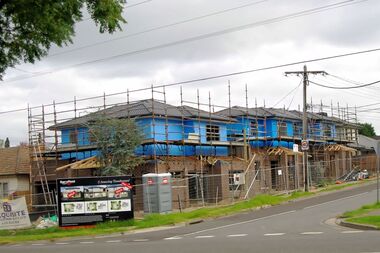 Greensborough Historical Society
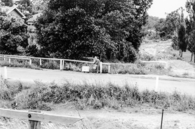
Photograph - Digital image, Marilyn Smith, Watsonia Road unit development , 2016, 24/05/2016
Unit development in Watsonia Road, Watsonia 2016.Digital copy of colour photograph.watsonia, watsonia road -
 Greensborough Historical Society
Photograph - Digital image, Marilyn Smith, Watsonia Road unit development , 2016, 24/05/2016
Unit development in Watsonia Road, Watsonia 2016.Digital copy of colour photograph.watsonia, watsonia road -
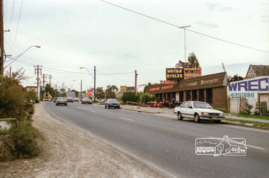
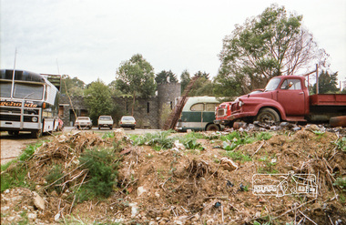
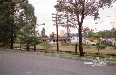
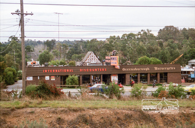
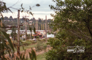
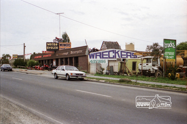 Eltham District Historical Society Inc
Photograph, Industrial development, Para Road, Briar Hill, c.1984, 1996
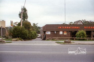
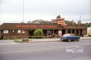
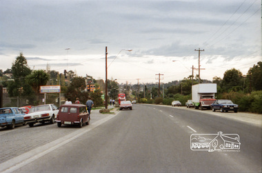
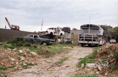
Views of industrial sites and shop fronts on Para Road, Briar Hill including the business 'Greensborough Motorcycles'. Para Road, Briar Hill is parallel to the Hurstbridge Railway Line. The building 'Greensborough Motorcycles' was destroyed by fire in the early 2000s.Roll of 35mm colour negative film, 4 stripsKodak CP 100 5094briar hill, greensborough, greensborough motorcycles, hutchinson's, industry, international discounters, para road -
 Eltham District Historical Society Inc
Photograph, Industrial development, Para Road, Briar Hill, c.1984, 1996
Views of industrial sites and shop fronts on Para Road, Briar Hill including the business 'Greensborough Motorcycles'. Para Road, Briar Hill is parallel to the Hurstbridge Railway Line. The building 'Greensborough Motorcycles' was destroyed by fire in the early 2000s.Roll of 35mm colour negative film, 4 stripsKodak CP 100 5094briar hill, greensborough, greensborough motorcycles, hutchinson's, industry, international discounters, para road -
 Eltham District Historical Society Inc
Negative - Photograph, Industrial development, Para Road, Briar Hill, c.1984
Views of industrial sites and shop fronts on Para Road, Briar Hill including the business 'Greensborough Motorcycles'. Para Road, Briar Hill is parallel to the Hurstbridge Railway Line. The building 'Greensborough Motorcycles' was destroyed by fire in the early 2000s.Roll of 35mm colour negative film, 4 stripsKodak CP 100 5094briar hill, greensborough, greensborough motorcycles, hutchinson's, industry, international discounters, para road, business -
 Eltham District Historical Society Inc
Photograph, Industrial development, Para Road, Briar Hill, c.1984, 1996
Views of industrial sites and shop fronts on Para Road, Briar Hill including the business 'Greensborough Motorcycles'. Para Road, Briar Hill is parallel to the Hurstbridge Railway Line. The building 'Greensborough Motorcycles' was destroyed by fire in the early 2000s.Roll of 35mm colour negative film, 4 stripsKodak CP 100 5094briar hill, greensborough, greensborough motorcycles, hutchinson's, industry, international discounters, para road -
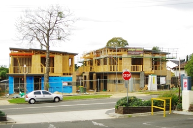
 Greensborough Historical Society
Photograph - Digital image, Marilyn Smith, 177-179 Watsonia Road, 2016, 24/05/2016
Redevelopment of 177-179 Watsonia Road, Watsonia 2016.Digital copy of colour photograph.watsonia, watsonia road -
 Eltham District Historical Society Inc
Photograph, Our Lady's Church and school buildings on the east side of Main Road, Eltham, February 1968, Feb 1968
Shows car parking at left across Main RoadIn February 1968 an unknown person took a series of photos from the Eltham Hotel at Pitt Street heading north along Main Road through the shopping centre to just north of Elsa Court covering the length of the section of Main Road which was duplicated shortly thereafter. Shows the condition and environment of the streesscape of Main Road, Eltham immediately prior to the duplication between Pitt Street and Elsa Court through the shopping centre. Also shows a number of shops and businesses that operated at that time.Black and white photographduplication, eltham, main road, our ladys church -
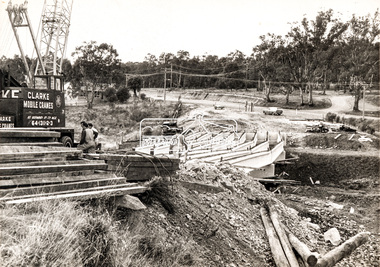 Eltham District Historical Society Inc
Photograph, Construction of new bridge over the Plenty River, Main Road, Lower Plenty, c.Aug. 1966
Construction of the Main Road bridge over the Plenty River. Includes structural members, construction personnel, vehicles and a Clarke mobile crane.Local significanceBlack and white printMarking on back of photograph - Plenty River Bridge Main Road 1969 (sic)lower plenty, main road, plenty river, bridge, bridge construction, civil engineering, cranes, mobile cranes -
 Ringwood and District Historical Society
Flyer, Executor's Auction Subdivision Advertisement, Lilydale Road and Oban Road, Ringwood East, Vic. - 1937
Single page advertisement for Executor's Auction of land in Ringwood East on Saturday, May 29, 1937 with locality map showing 26 building sites for auction highlighted in brown, and brief summary of local services available. Subdivision includes Old Lilydale Road, Joseph Street, Dynes Street, Albert Street (later Wyrunga Street), Carcoola Road, and Mount Dandeong Road. (Carcoola Road incorrectly shown as Oban Road on the subdivision plan). Auctioneer - C.E. Carter, (Phone Ringwood 24. -
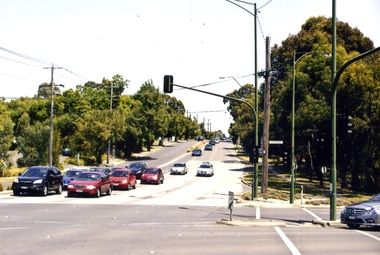 Whitehorse Historical Society Inc.
Photograph, Blackburn Road/Canterbury Road, Blackburn South, 2012
See NP4006Coloured photograph of the Blackburn Road and Canterbury Road intersection. Cars heading east on Canterbury Road towards Vermont.blackburn road, blackburn south, canterbury road -
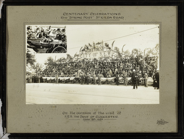 Kew Historical Society Inc
Photograph, The Sears Studio, Centenary Celebrations : Kew "Strong Post" St Kilda Road, 1934
Cr. W.D. Vaughan in 'Kew's Civic History' (1960) records that: "In connection with the Melbourne Centenary Celebrations in 1934, the Kew Council decided to organise a strong post as an appropriate gesture of welcome to H.R.H. the Duke of Gloucester. Also that the municipality be represented by a symbolic floral float in the Royal pageant. This was a striking entry and won first prize, and evoked much comment on account of its originality and truly Australian motif." The photograph of the Kew Strong Post was once part of the Municipal Collection of the former City of Kew and was presented to the Kew Historical Society before the move from the Walpole Street (Kew) Town Hall to new Civic offices in Charles Street in 1971.Historic photograph of participation by the City of Kew in celebrations for a royal visitFramed and glazed photograph on its original inscribed mount and original frame of the Kew "Strong Post" in St Kilda Road on the occasion of the visit to Melbourne of the Duke of Gloucester. The photograph has two components, at the upper left is a photo of the royal carriage while the man photo shows the people of Kew on a decorated 'Strong Post' on St Kilda Road, along which the procession progressed. T"Centenary Celebrations / Kew "Strong Post" St Kilda Road / On the occasion of the visit of / H.R.H. The Duke of Gloucester / October 18th 1934."royal visits - melboure - 1934, duke of gloucester, kew (vic.) — municipal collection -
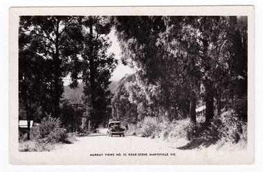 Marysville & District Historical Society
Postcard (item) - Black and white postcard, Murray Views, Murray Views No. 30. Road Scene, Marysville, Vic, Post 1929
An early black and white photograph of a road scene taken in Marysville, Victoria.An early black and white photograph of a road scene taken in Marysville, Victoria. This postcard was produced by Murray Views in Gympie, Queensland as a souvenir of Marysville."Kooringa"/ Monday Dear Mother/ Just a short note/ to say I am well & having a/ good holiday. Went on the/ Cumberland Valley trip last/ week - was very enjoyable./ To-day we are doing the Eildon/ Weir trip - all day. Have had/ fairly good weather - was able/ to go out every day. Will/ ring you later in the week/ about meeting me. If the/ strike is still on will probably/ get you to order a taxi for/ me. Lots of love/ Margaretmarysville, victoria, postcard, murray views, souvenir