Showing 659 items matching " survey plan"
-
 St Kilda Historical Society
Photograph - Photo map, 22/01/1970
One of a series of photo-maps produced for the Department of Crown Lands and Survey (1857-1983). For correlation with a current map, and access to other historical photo maps of Victoria, see the Historic Photo-Maps Index published by the Department of Environment, Land, Water and Planning at https://services.land.vic.gov.au/DELWPmaps/historical-photomaps/Black and white aerial photographVic 2358 Department of Crown Lands and Survey Victoria,.© Melbourne 1970 Project Run 43E 22.1.70 5,100 ASL 206elwood, elsternwick, elsternwick park, 1970 -
 Tatura Irrigation & Wartime Camps Museum
Book, Warwick Finlay, The Doctor, The Captain, The Poet and Others, 2004
This book was printed to commemorate the 150th Anniversary of the survey, naming of the town and sale of land at Murchison.Black and white cover featuring the Goulburn River and portraits of Doctor McMillan, Captain John Murchison and Orion Horne over and early plan of Murchison Townshipmurchison -
 Tatura Irrigation & Wartime Camps Museum
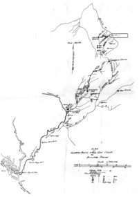
Map - Map - Photocopy, New Guinea Escape Route
... Plan of surveyed route from Edie Creek to Bulldog Drome... willi hertle kiessling Plan of surveyed route from Edie Creek ...At the end of January 1942 there was only about 250 men left in Wau, as the women and children had been evacuated by air a little earlier. With no planes to take the men they had to make their own way to Port Moresby and then travel by ship to Australia. Some men went down to Salamaua and made their way along the north coast, but small groups also made their way over the Owen Stanley Ranges; rafting down the Lakekamu RIver to Yule Island and by boat to Port Moresby. Donor Vanessa Kiessling's Father was part of the second group, and had drawn a detailed map of their route. This might be the same route taken by Rev. Willi Hertle (Ref C0750)Photocopy of New Guinea map showing escape routePlan of surveyed route from Edie Creek to Bulldog Dromepapua new guinea, escape, map, wau, willi hertle, kiessling -
Tatura Irrigation & Wartime Camps Museum
Book, Adolf Wilke, 15 September 1944 - 1 May 1946
Surveyors book compiled by POW Adolf Wilke who was lecturer in surveying at Camp 13, Murchison.Handmade hard cover, hand stitched book consisting of figures and plans in ink and pencil. 69 numbered pages.adolf wilke, surveying, camp 13 surveying -
Victorian Aboriginal Corporation for Languages
Book, C C Culvenor, The boundaries of the Mount Franklin Aboriginal Reserve, 1992
"This enquiry into the boundaries of the Mount Franklin Aboriginal Reserve had its origins in the preparation of a biography of geologist Thomas Smith of Sandon, which raised queries about Boundary Gully Road, Parkers Gully and the location in that vicinity of the Reserve boundary. At a subsequent meeting of the Daylesford Historical Society, commemorating the 150th anniversary of the founding of the Aboriginal Reserve at Franklinford in 1841, it became clear that the actual boundaries were only poorly known ... A search for information srouces in Melbourne and Sydney did not produce an overall Plan, but it is hoped that the material obtained will present a sufficiently accurate picture to be useful to other local historians and be of some interest also to the general reader" --Preface. Contents: The boundaries of the Mt. Franklin Aboriginal Reserve The five mile radius The Tarrengower challenge Provisional boundaries Survey of the Reserve Breakup of the Reserve References Appendices.maps, b&w illustrations, b&w photographsmount franklin -
 Victorian Aboriginal Corporation for Languages
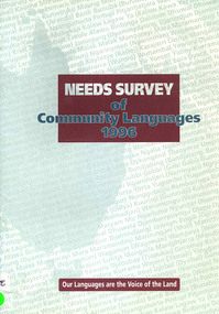
Book, Aboriginal and Torres Strait Islander Commission Broadcasting, Languages, Arts and Culture Section, Needs survey of community languages 1996, 1996
... , survey The survey aims to document the Indigenous language ...The survey aims to document the Indigenous language situation and to establish the extent of Indigenous language needs so as to provide a sound basis for further program planning.maps, surveyeducation policy, language policy -
University of Melbourne, Burnley Campus Archives
Document, John Patrick, Burnley Gardens Design & Management Plan 2. Educational Survey, 1980
... Burnley Gardens Design & Management Plan 2. Educational... management plan Report by John Patrick, Dept. of Agriculture Victoria ...Report by John Patrick, Dept. of Agriculture Victoria. 18 pp.john patrick, burnley gardens, design, management plan -
University of Melbourne, Burnley Campus Archives
Document, Graduate Destination Survey 2003, 2004
... Boulevard Richmond melbourne graduates survey 2003 university ...University of Melbourne, University Planning Officegraduates, survey, 2003, university of melbourne -
Clunes Museum
Plan
... Clunes Museum 36 Fraser Street Clunes goldfields PLAN HAS ...PLAN HAS AN ATTACHED HAND PRINTED CARD WITH INFORMATION REGARDING SITES. THIS HAS BEEN ADDED AT A MUCH LATER DATE.1 PAGE - AN EARLY, UNDATED PLAN OF THE TOWNSHIP OF CLUNES, COUNTY OF TALBOT, SHOWING REDUCED LEVELS AND CHAIN SURVEY OF ALL SECTIONSlocal history, plans -
 Peterborough History Group
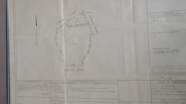
Map - survey of Hamilton St wetland, Plan of Subdivision Hamilton Street
Subdivided to preserve the wetland, locals estimate it occurred between 1976 and 1983A3 plan of subdivision showing the outline of the swamp bounded by Hamilton St, Charles St and Cumming St. peterborough, survey map, golden pond -
Stawell Historical Society Inc
Map, R.O. Robson - Authorised Surveyor, Road from Glenorchy to near Geary's Selection Callawaddy 1880, 29.04.1880
Survey for Road CreationCloth Backed Map. Plan of Road.Parishes of Richella & Callawadda. County of Borong. Plan of Road. R.O. Robson Authorised Surveyor Stawell 29.04.80 -
Stawell Historical Society Inc
Map, Plan of Division Line between Ararat and Stawell Shires 1877, 1877
Grampians Halls Gap Black Range Stawell Shire Ararat Shire Crowlands TownshipVery Large Map Printed on Linen with Table of bearingsExamined by H.C. Malcolm 28.12.77 Traced By D.H. Meike 28.12.77survey -
Koorie Heritage Trust
Book, Broom, Leonard, A blanket a year, 1973
... Federation Square, Melbourne melbourne Aborigines. Social planning ...Land rights, perhaps the best known of Aboriginal grievances, is bitterly expressed in 'All they give us now for our land is a blanket once a year'. Yet, as Broom and Jones show in this book, the Aborigines are disadvantaged in every way. No one knows who are Aborigines, how many there are, what jobs they hold, what education they have received. Yet, until this extraordinary ignorance is rectified, there is no basis for planning vital improvements. The authors stress the urgent need for public authorities to gather information on Aboriginal health, housing, employment, and education. Without this information no attempt to overcome the gross inequalities can hope to succeed. A Blanket a Year offers constructive professional help. It is vital reading for politicians, administrators, social workers, educationists, and for all fair-minded Australians.98 p. ; notes; tables; references; 23 cm.Land rights, perhaps the best known of Aboriginal grievances, is bitterly expressed in 'All they give us now for our land is a blanket once a year'. Yet, as Broom and Jones show in this book, the Aborigines are disadvantaged in every way. No one knows who are Aborigines, how many there are, what jobs they hold, what education they have received. Yet, until this extraordinary ignorance is rectified, there is no basis for planning vital improvements. The authors stress the urgent need for public authorities to gather information on Aboriginal health, housing, employment, and education. Without this information no attempt to overcome the gross inequalities can hope to succeed. A Blanket a Year offers constructive professional help. It is vital reading for politicians, administrators, social workers, educationists, and for all fair-minded Australians.aborigines. social planning. information requirements. australia. surveys | aboriginal australians -- social conditions. | australia -- social policy. | -
Koorie Heritage Trust
Book, Aboriginal Affairs Victoria in conjunction with the Kerrup Jmara Elders Aboriginal Corporation, Lake Condah Heritage Management Strategy and Plan, 1993
During its 1977/78 summer field school season, the (then) Victoria Archaeological Survey began recording and mapping the stone fish trap and 'house' sites along the southern margins of Lake Condah, near Portland Victoria. This and subsequent archaeological work at Lake Condah and in the general region demonstrates that, on the basis of a number of criteria, the Aboriginal heritage sites found here are significant.vii, 388 p., [11]. leaves. : ill., foldout maps. ; 30 cm.During its 1977/78 summer field school season, the (then) Victoria Archaeological Survey began recording and mapping the stone fish trap and 'house' sites along the southern margins of Lake Condah, near Portland Victoria. This and subsequent archaeological work at Lake Condah and in the general region demonstrates that, on the basis of a number of criteria, the Aboriginal heritage sites found here are significant.conservation of natural resources -- victoria -- condah, lake, region. | aboriginal australians -- victoria -- condah, lake, region -- antiquities. -
Koorie Heritage Trust
Book, Baragwanath, W, Memoirs of the Geological Survey of Victoria : No. 15 The Aberfeldy District, Gippsland, 1925
15 v. : ill., plates, maps, plans, diagrs. ; 34 cm. lcsh: 1. geology -- victoria -- periodicals. 2. geology -- victoria. i. geological survey of victoria. ii. victoria. dept. of mines. -
Whitehorse Historical Society Inc.
Document, Division of Survey and Mapping, 1984
... Information guide to Parish and Township Plans - Division... Information guide to Parish and Township Plans - Division of Survey ...Information guide to Parish and Township Plans - Division of Survey and Mapping - Victorian Government..Information guide to Parish and Township Plans - Division of Survey and Mapping - Victorian Government..Information guide to Parish and Township Plans - Division of Survey and Mapping - Victorian Government..crown lands, victorian government, land surveys -
 Whitehorse Historical Society Inc.
Map, Schwerkolt property and rough plan of old stone house, 1993
Map drawn by Arthur SchwerkoltMap drawn by Arthur Schwerkolt in 1993 from memory assisted by survey map of 1902. Covering letter from Glyn France [also at ND1367 (G-H-S-C 46) gives extra details.Map drawn by Arthur Schwerkoltschwerkolt cottage, schwerkolt, arthur, whalen, rosalie, france, glyn -
Whitehorse Historical Society Inc.
Map, Plan of the Parish of Nunawading, 1853
Photocopy of map showing names of selectors, also list of references to the corners of allotments.Photocopy of map showing names of selectors, also list of references to the corners of allotments. Note on verso:'Gardiners Creek, Ballyshanassey township surveyed by H. Parmein, Surveyor General's Office Nov 30, 1853 also Reference to the Corners of allotments' (Plan 428)Photocopy of map showing names of selectors, also list of references to the corners of allotments. land subdivision, gardiners creek, ballyshanassy, parmein, h, burwood east, maps -
Whitehorse Historical Society Inc.
Map, Plan of special survey selected by H. Elgar Esq, 1841
... Plan of special survey selected by H. Elgar Esq.... Note on verso: Plan of special survey selected by H... on verso: Plan of special survey selected by H. Elgar Esq... Mitcham melbourne Note on verso: Plan of special survey selected ...Photocopy of plan and listing of corner stakes.Photocopy of plan and listing of corner stakes. Note on verso: Plan of special survey selected by H. Elgar Esq in the Parishes of Boroondara and Nunawading, County of Bourke. Surveyed by T.H. Nott (?Sydney) 31 May 1841. Boroondara Special Survey B.17, with attached descriptive note by T. H. Nott.Photocopy of plan and listing of corner stakes. maps, parish of boroondara, parish of nunawading, elgar, h, nott, t.h. -
 Whitehorse Historical Society Inc.
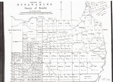
Document, Plan of Parish of Nunawading, 01/05/1864
Copy of plan of Parish of NunawadingCopy of plan of Parish of Nunawading, County of Bourke, lithographed at the Office of Lands and Survey, Melbourne, 13th May, 1864 showing boundaries of Koonung, Mullum Mullum and Dandenong Creeks.Copy of plan of Parish of Nunawadingland subdivision, parish of nunawading, county of bourke, elgars special survey, koonung creek, mullum mullum creek, dandenong creek -
Whitehorse Historical Society Inc.
Map, Subdivision of Allotment 122a, 1972
... on this plan is in proclaimed survey No 21. Survey Coordination Act... 'Land on this plan is in proclaimed survey No 21. Survey... 'Land on this plan is in proclaimed survey No 21. Survey ...Subdivision of land along Livermore Close and Moore Road, Vermont South.Subdivision of land along Livermore Close and Moore Road, Vermont South. Original survey Rob Poole 1899. Stamp indicates 'Land on this plan is in proclaimed survey No 21. Survey Coordination Act 1940. As from 9 Aug 1972. Two maps in different scales.Subdivision of land along Livermore Close and Moore Road, Vermont South. land subdivision, livermore close, vermont south, moore road, vermont south, dandenong creek -
 Whitehorse Historical Society Inc.
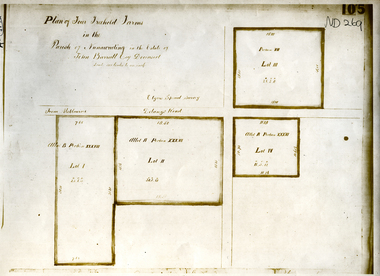
Document, Parish of Nunawading
... ringwood north elgars special survey land subdivision Plan of four ...Plan of four farms in the estate of John BarrattPlan of four farms in the estate of John Barratt on Delaneys RoadPlan of four farms in the estate of John Barratt parish of nunawading, barratt, john, delaney's road, ringwood north, elgars special survey, land subdivision -
Whitehorse Historical Society Inc.
Booklet - Pamphlet, A Historical survey of Melbourne's water supply, 1942
Based on an address by J.C. Jessop, 8 May 1942. With plan of Melbourne's water supply system.Based on an address by J.C. Jessop, 8 May 1942. With plan of Melbourne's water supply system.Based on an address by J.C. Jessop, 8 May 1942. With plan of Melbourne's water supply system.water supply, melbourne and metropolitan board of works., blackburn, james, hodgkinson, clement, oldham, t -
Whitehorse Historical Society Inc.
Document, Course land ownership documents, 1965
... transactions and survey documents. Plan and accompanying land ...Plan and accompanying land transactions and survey documents.Plan and accompanying land transactions and survey documents and progression of ownership of property acquired by William Course in Nunawading from 1858 to 1883, including the Parkmore State School site.Plan and accompanying land transactions and survey documents.course family, course william, land titles, parkmore state school no 4881 -
Whitehorse Historical Society Inc.
Map, Blackburn East Primary School
Proposed master plan 1955?Proposed master plan 1955? With Public Works Dept. detail survey 1979. Rolled map.Proposed master plan 1955? blackburn east primary school no. 4800, public works department -
Whitehorse Historical Society Inc.
Map, Survey for road from Doncaster to Ringwood, 01/03/1867
Survey in County of Bourke, Road Plan no. 390, showing early routes of Doncaster, Whitehorse and Mitcham Roads.Survey in County of Bourke, Road Plan no. 390, showing early routes of Doncaster, Whitehorse and Mitcham Roads. Measurement in chains. Surveyor: Thomas E. Rawlinson.Survey in County of Bourke, Road Plan no. 390, showing early routes of Doncaster, Whitehorse and Mitcham Roads. parish of nunawading, parish of bulleen, whitehorse road mitcham, doncaster road, doncaster east, mitcham road mitcham -
 Rutherglen Historical Society
Map, 1908
This is a map produced as part of a book entitled.. It is also stamped on the back in blue ink with an oval ring and the words North of England Institute. Newcastle. Mining & Meterolgical Faculty. Purchased on 23rd July 2017 by the Society after research by member Simon Killeen. Mining map of one of the first mines in Rutherglen area ( Chiltern West)Cream paper, black printing, rectangle with a drawingGeographical Survey of Victoria, Memoir, No6. Plate XX Plan of Underground Workings CHILTERN VALLEY CONSOLS MINE, RUTHERGLEN, PARISH OF CHILTERN WESTgold, rutherglen, mining, chiltern, underground mine map, geological survey, reef drives -
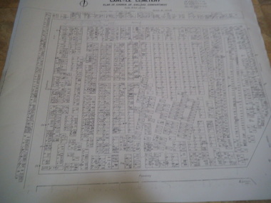
 Rutherglen Historical Society
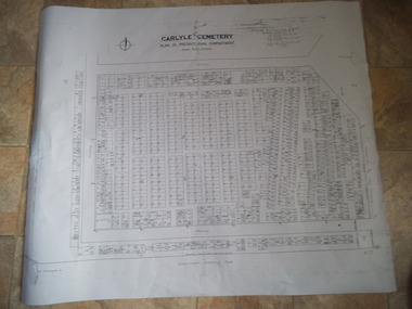
Carlyle Cemetery Map, Plan of Presbyterian Compartment, 1952
This is a map produced to attempt to bring order to the cemetery. Originally the layout was not well defined and it is difficult to use this plan to locate a particular grave, also the fact that not all graves are marked and foot paths are not defined has exacerbated this issue. Photocopy, White paper, black printing, black line work showing lot and compartment boundariesReferences Grid Survey points at 50 feet centres shown (as a cross with the reference mark number in brackets) Lot Number shown at left side of graves. Burial Number shown at right side of grave. Lots with unidentified burials show with dashed cross with in the lot. topographic survey, cadastral survey, carlyle cemetery, burials, graves, lot boundary, rotunda -
 Rutherglen Historical Society
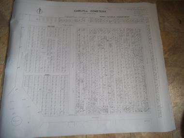
Carlyle Cemetery Map, Plan of Roman Catholic Compartment, 1952
This is a map produced to attempt to bring order to the cemetery. Originally the layout was not well defined and it is difficult to use this plan to locate a particular grave, also the fact that not all graves are marked and foot paths are not defined has exacerbated this issue. Photocopy, White paper, black printing, black line work showing lot and compartment boundariesReferences Grid Survey points at 50 feet centres shown (as a cross with the reference mark number in brackets) Lot Number shown at left side of graves. Burial Number shown at right side of grave. Lots with unidentified burials show with dashed cross with in the lot. topographic survey, cadastral survey, carlyle cemetery, burials, graves, lot boundary, rotunda -
 Rutherglen Historical Society
Carlyle Cemetery Map, Plan of Church of England Compartment, 1952
This is a map produced to attempt to bring order to the cemetery. Originally the layout was not well defined and it is difficult to use this plan to locate a particular grave, also the fact that not all graves are marked and foot paths are not defined has exacerbated this issue. Photocopy, White paper, black printing, black line work showing lot and compartment boundariesReferences Grid Survey points at 50 feet centres shown (as a cross with the reference mark number in brackets) Lot Number shown at left side of graves. Burial Number shown at right side of grave. Lots with unidentified burials show with dashed cross with in the lot. topographic survey, cadastral survey, carlyle cemetery, burials, graves, lot boundary, rotunda