Showing 845 items
matching surveyor
-
 Orbost & District Historical Society
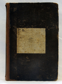
book, Effingham, Wilson, A Geographical Dictionary of the Australian Colonies, 1848
A geographical dictionary or gazetteer of the Australian colonies : their physical and political geography : together with a brief notice of all the capitals, principal towns, and villages. William Wells travelled to Australia as a sponsored immigrant in 1838. Her became a freelance surveyor with an office in Bligh Street, Sydney. He wrote this book in order to better inform the British public on the colonies of Australia. The information contained in the book is both topographical and statistical and was a very useful refernece book at the time.This book is a rare detailed contemporary record of the Australian colonies in the mid 19th century.A hard back 453 pp book with a dark brown patterned cover which has a white label with the title, "Dictionary of Geography" over a map of Australia. It is illustrated with numerous maps and drawings.history-australia wells-william-henry geographical-dictionary-of-the-australian-colonies -
 Glenelg Shire Council Cultural Collection
Certificate - Certificate - Historic Buildings, Portland Town Hall, 1974
From the Victorian Heritage Register: The foundation stone of the original Portland Town Hall was laid by William Learmonth on 21st September, 1863 following a competition and subsequent public controversy over the permitted entry of architect John Barrow. The conservative classical design of municipal surveyor Alexander Ross was preferred and this axially planned design with central council chamber and side offices fronted by a fine axed pedimented gable entablature of basalt and Tuscan Doric pilasters was completed by 24th may 1864. The old Town Hall is one of a distinguished group of public buildings in Portland and an interesting example of conservative classical architecture of the first years of settlement in western Victoria. The basalt structure was partially erected of stone from the Portland stockade and has significant historical associations with local Government administration in the district. The Town Hall is the most impressive work of Alexander Ross, a surveyor architect whose career remains largely undocumented. The old Town Hall at Portland has been discreetly extended at the rear to provide additional meeting room accommodation. The premises are no longer used for local government administration.A4 sized certificate demonstrating Portland Town Hall's special significance to the state of Victoria & inclusion on the Historic Building Register. Singed by Robert Maclellan, Minister for planning & Historic Buildings Council Chairperson. Red seal attached, bottom right.portland town hall, history house, heritage register, historic buildings, certificate -
 Ringwood and District Historical Society
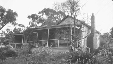
Photograph, "Johnswood" - Home of Charles Wedge, Eastfield Road, East Ringwood - 1964 (demolished in 1967)
Black and white photograph of weatherboard house. (2 copies- 1 large, 1 small)Written on backing sheet of large copy: " 'Johnswood', Home of Charles Wedge, President of old Ringwood East Progress Association. Related to John Helder Wedge, Batman's surveyor.1964." Written on back of small copy: "Home of CHarles Edward Lyndhurst Wedge. Died 1962." Demolished 1967 -
 Ringwood and District Historical Society
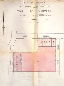
Document, Plan of Subdivision - Part of Crown Allotment 10A, Parish of Ringwood, County of Mornington - 1957
Map of residential allotments in Wantirna Road and Reilly Street, Ringwood, and Philip Street, Heathmont, Vic.Footnote includes "Lots numbered 5 to 11 and 16 to 23 both inclusive are not included in this plan. Signature of Consulting Engineer - Alan J. Brown BCE, LS, MVIS, Licensed Surveyor, Dillons Buildings, 1 Riversdale Road, Camberwell (Phone) WF3528 dated 1-4-1957. -
 Bendigo Historical Society Inc.
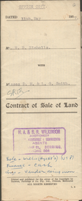
Document - H.A. & S.R. WILKINSON COLLECTION: CONTRACT OF SALE
Contract of sale of land dated 11th May, 1957 between Mr. W.B. Nicholls (seller) and Misses D.M. & L.G. Smith. For land being lot 8 on vendor's plan of subdivision by Mr. Surveyor Pritchard, dated 2nd May, 1957 having a frontage of 59 feet to Alamein Court by a depth of 100 feet, being part allotment 7 section 31A land described in Crown grant volume 8113 folio 731. Subject to any registered appurtenant easements. Price 3,600 pounds.organization, business, h.a. & s.r wilkinson real estate -
 Bendigo Historical Society Inc.
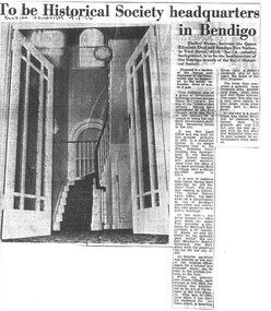
Slide - DUDLEY HOUSE COLLECTION: DIGITAL IMAGES, 1974-2013
Four digital images of newspaper articles about Dudley House. a. Bendigo Advertiser 4.8.1974 Announcement that the Bendigo Branch of the RHSV is to occupy Dudley House. b. Bendigo Advertiser 9.9.2003. Article ''Our Institution's includes information on Dudley House. c. Bendigo Advertiser 17.2.2006. Article about Richard Larritt - first surveyor written by Jim Evans. d. Bendigo Advertiser 7.11.2013. ''History Lives''. ""Notices Shed New Light" - exploring the origins of the name "Dudley House'' written by Jim Evans.slide, bendigo, bendigo advertiser images -
 Bendigo Historical Society Inc.
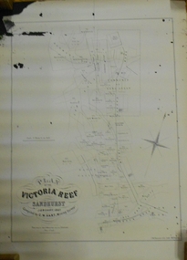
Document - MARKS COLLECTION: MAP OF VICTORIA REEF MINING CLAIMS
Copy of map. On bottom LH side: Plan of the Victoria Reef Sandhurst January 1867, Compiled by G.W. Hart, Mining Surveyor. Published by John N. Macartney, Argus Agent, Sandhurst. Price 4/- each. On bottom Rh side J.W. Pearson & Co. Lith. Melbourne Plan shows mining claims and names of holders, scale (4 chains to one inch) Loddon Road, Mount Korong Road, Ironbark Gully, township of Long Gully, Quartz Miners' Arms and Gold Mines Hotel on Loddon Road.bendigo, mining, victoria reef plan -
Port Melbourne Historical & Preservation Society
Map - Survey Map, Captain R Pasley R E, 24 Sep 1855
Survey map to accompany Colonial Engineers Report, September 1855melbourne -
Port Melbourne Historical & Preservation Society
Plan - Township of Sandridge, 1855
COPYRIGHT PUBLIC RECORDS OFFICE Plan of the Township of Sandrdge 1855 - copy from Public Record Office 1978local government - municipal district of sandridge, town planning, j jones -
 Ballarat Tramway Museum
Negative - Geelong tram 36 Mercer St, Laurie Gallop, early 1956
Photo shows Geelong tram 36 outbound to North in Mercer St at Ginn St. In the background is a shop selling Franklins Lemon Swish, a four & Twenty Pie shop, Toppa Ice cream, a Coca Cola truck, a Hotel advertising Richmond Lager, three parked buses and a shop advertising hot pies. On the pole is a tram stop with a metal "CARS STOP HERE" sign. On the left-hand side of the photograph a surveyor can be seen at work.Yields information about the Geelong operations toward the closure of the tram system.Black and white Negative - 120 sizetramways, geelong, mercer st, tram 36, tram stops -
 Ringwood and District Historical Society
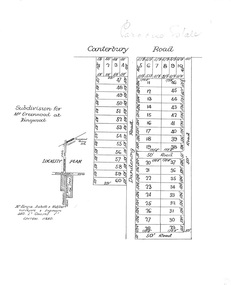
Plan, Paradise Estate Subdivision, Ringwood, Victoria - circa 1925
Paradise Estate layout also included in Land Sale Brochure Titled Eureka Plan Book - Seven Delightful & Valuable Ringwood Estates - circa 1925, Reg. No. 5100.Subdivision plan of Paradise Estate, Ringwood, showing allotments for sale, with typed page attached showing block sizes and prices.Locality plan showing land for sale south of Canterbury Road, 1 Mile south of Ringwood Railway Station. Subdivison includes Canterbury Road and Dandenong Road (later Wantirna Road). Surveyors - McKenzie Aisbett & Webber, surveyors & engineers, 440 Little Collins Street, Melbourne, Telephone Central 11540. Subdivision for Mr Grenwood at Ringwood. Additional typewritten price list showing footage, price per foot, and price per block for Lots No. 1 to 60. Paradise Estate layout also included in Land Sale Brochure Titled Eureka Plan Book - Seven Delightful & Valuable Ringwood Estates - circa 1925, Reg. No. 5100. -
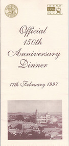 Warrnambool and District Historical Society Inc.
Document, Menu 150th, 1997
This is the program for the dinner celebrating Warrnambool’s 150th anniversary. Warrnambool was established in 1847 as a planned town in response to the need for a new port to be established to service the pastoralists who had occupied land nearby. Superintendent La Trobe authorized the establishment of the town and probably gave it its name. The surveyor of the 250 acre grid that today comprises most of the Central Business District was William Pickering. The 150th anniversary celebrations were organized by an 150th Anniversary Committee headed by Frank JacobsThis program is of minor interest as a memento of the important 150th anniversary celebrations held in Warrnambool in 1997. This is a buff-coloured A3–size sheet folded into three to make six pages of printed material. These include sepia-tone photographs, the menu for the dinner, the official crest of the Warrnambool City Council and the 150th anniversary celebrations logoFront cover: ‘Official 150th Anniversary Dinner, 17th February 1997’warrnambool’s 150 anniversary celebrations -
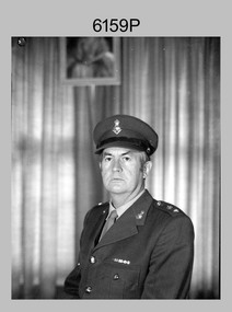 Bendigo Military Museum
Photograph - CO Army Survey Regiment - LTCOL Constantine AM, Fortuna, Bendigo, 1975-1976
This is a photograph of LTCOL Peter Constantine AM, who was the CO of the Army Survey Regiment from 1975 to 1976. He then assumed command of the School of Military Survey (SMS) from 1976 to his retirement in January 1982. LTCOL Constantine was one of RASvy’s most revered officers in this era, with 32 years of meritorious service as a leader on active duty in Vietnam in 1969 and the commanding officer of the Regiment and School. His memoirs of active duty in Vietnam ‘Surveyor - Printer Behind the Lines’ was published in 2022.This is a photograph of LTCOL Peter Constantine AM, who was the CO of the Army Survey Regiment at Fortuna, Bendigo, from 1975 to 1976. The black and white photograph was printed on photographic paper and is part of the Army Survey Regiment’s Collection. The photograph was scanned at 300 dpi. There is no annotation.royal australian survey corps, rasvy, army survey regiment, army svy regt, fortuna, asr -
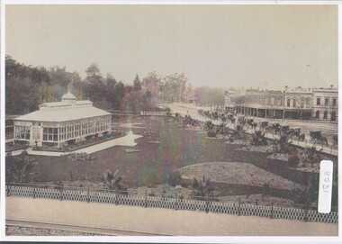 Bendigo Historical Society Inc.
Photograph - Bendigo Conservatory and gardens
Fifty nine acres of land was reserved for a park in1861, and the first gardener began setting out the gardens in 1870. The conservatory was built in 1897 and is the last building of its type in a public park.The conservatory was designed by Mr G. Minto, city surveyor at the time. The building is 72 feet long and 24 feet wide. The walls re twenty two feet high and are topped by a lantern roof, adding a further six feet. It was built at a cost of between 700 and 800 pounds.B&W photograph with view over the Bendigo Conservatory and gardens with a line of twelve horse drawn cabs on Bridge Streetconservatory gardens, bendigo -
 Kew Historical Society Inc
Map, Robert Russell, Map Shewing the Site of Melbourne and the Position of the Huts & Buildings Previous to the Foundation of the Township by Sir Richard Bourke in 1837
Map shows the first layout of Melbourne by Government surveyor Robert Russell, who accompanied Governor Richard Bourke in 1837. The surveyed blocks extend from present-day Flinders Street to Lonsdale Street, and Spring Street to Spencer Street, with extensive vacant land west to a salt lake (afterwards Batman's Swamp, later drained), north beyond Flagstaff Hill and south towards South Melbourne. Vegetation coverage is indicated, and tracks and existing buildings and cultivated land are shown.Printed map was created by Day & Haghe, Lithographers to the Queen, sometime after 1838, when the company received its Royal appointment. Copies of the 1837 map exist in several major map collections in Australia; most are uncoloured. This particular map is the earliest in the Kew Historical Society's map collection. It is a nationally significant artefact. Black and white lithographed map hand-coloured in blue and yellow gouache of the town of Melbourne in 1837. In contrast to the original lithograph, the river and the township blocks are coloured blue and yellow. A similar, partly coloured copy is in the collection of the University of Melbourne.maps - melbourne - 1830s, governor sir richard bourke, robert russell - surveyor, cartography -
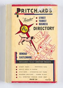 City of Greater Bendigo - Civic Collection
Book - Street Directory, A. E. Pritchard, Pritchards 'Pointer' Street - Tourist - Business - Directory, 1953
As tourism and car culture grew in the early and mid 20th century the need for street and touring directories grew. Bendigo's geographic location within central Victoria and relatively closeness to Melbourne meant that the district has long been an ideal car touring destination. A. E. Pritchard was a licensed surveyor with an office in Bull Street Bendigo and produced these handy bound directories which fit neatly into the car glovebox therefor serving both the local and state demand for high quality printed directories such as these. One hundred and thirty page printed and bound street and touring directory. Includes fold out reference and day touring maps, photographs of local 'beauty' spots and extensive advertising by local businesses. Heavy card used for front and back covers. Three colour print process.Pritchards 'Pointer' Directory Bendigo - Castlemaine.city of greater bendigo commerce, city of greater bendigo tourism, city of greater bendigo leisure, making a nation exhibition, cambridge press, mayor w cambridge -
Melbourne Legacy
Article - Speech, Foundation Day Address 2024, 2024
A foundation day speech in 2024 by Shrine Trustee and Past President, Legatee Graeme Plumridge. In a very well research piece he focussed on Legacy's close connection with the Shrine of Remembrance. Legatees were instrumental in saving the Shrine project from being discarded in the 1920s. Legatees such as Legatee Kemsley and Legatee Joynt were crucial in getting the project support from Sir John Monash. Legatee Frank Doolan was the surveyor of the site and key to calculating the positioning of the Ray of Light.A speech given at a Legacy function to commemorate the day on which Legacy was founded that has information about the connection between Legacy and the Shrine of Remembrance.White A4 paper x 6 pages with black print of 2024 speech by Legate Graeme Plumridge.foundation day, graeme plumridge, shrine of remembrance -
 Bendigo Military Museum
Journal - Desert Exploration - Extract from Northern Territory Lands and Survey Dept Annual Report 1960-61, Northern Territory Lands and Survey Branch, 1961
This Extract from Northern Territory Lands and Survey Dept Annual Report 1960-61 is about Desert Exploration between Wave Hill and Tennant Creek. The 2 x fold out maps are 1:1,000,000 scale with one showing a Levelling Traverse. The exploration took place during March and April 1960. This document has been included in the RASvy collection because it was valuable information that was needed by RASvy surveyors who were required to operate in the area in later years.5 x foolscap sized pages and 2 x map foldout pages held together with a slide clip. Pages and maps are two hole punchedroyal australian survey corps, rasvy, fortuna, army survey regiment, army svy regt, asr -
The Ed Muirhead Physics Museum
Slide Rule, cylindrical / “FullerCalculator”
“FULLER CALCULATOR” : a wooden cylindrical slide rule(92.1) with spiral logarithmic scale 500 inches long. and specially made rectangular box (92.2) and pamphlet (92.3).Engraved on metal of adding machine (92.1): “8462/45” Label on inside of box: “Stanley Trademark Everything for the Engineer Architect and Surveyor in field and drawing office. W.F.Stanley & Co. Ltd, 286 High Holborn London WC1” Stamped on pamphlet: “University of Melbourne Department of Statistics” Label on top box: “display” -
 Bendigo Historical Society Inc.
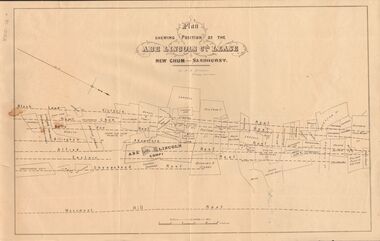
Document - MARKS COLLECTION: ABE LINCOLN CO LEASE
Two copies of plan for Abe Lincoln Co. Lease, New Chum, Sandhurst. One original, one copy. On top of plan 'Plan Showing Position of the Abe Lincoln Co. Lease, New Chum, Sandhurst' under name 'by H.B. Nicholas, Mining Surveyor' Sheepshead Reef, Easter reef, Alfred Reef, Allingham Reef,Adventure Reef, Belle Vue Reef, New Chum Reef, Black Lead, Victoria Reef lines shown on map with mine leases marked. On bottom of map 'Monument Hill Reef' line marked.bendigo, mining, abe lincoln lease -
Glenelg Shire Council Cultural Collection
Functional object - Survey Marker - Tyers' Surveyors' bearings slab, n.d
Displayed in History House.Wooden slab, painted white, carved inscription on face. Encased in wooden case with glass front.Front: LAT. 38. 21.34 S/Long. 141.41E/Var 5.30E (front, incised) Back: (from previous worksheet) Remains of Sheoak Stump from Allot 5 St Portland with lat de and long de cut in by Govt. Surveyor in the year 1840/T.W. 21-4-1900 (black print) -
Glen Eira Historical Society
Article - COANE, JOHN MONTGOMERY
This file contains one item about Coane and his family: 1/A one page extract from The Australian Dictionary of Biography Vol. 8 page 35 on John Montgomery Coane, Surveyor and Consulting Engineer, his partnership with George Hudson and later when his two sons joined the business. It details many of the projects he designed for rural Victoria and New South Wales and his other areas including Consulting to The Pacific Phosphate Co. Ltd of London and to the City of Brighton where he lived.coane john montgomery, blacker’s orchard & cannery co., victorian institute of surveyors, county donegal, ireland, mordialloc, ballyshannon, mines department sludge abatement board, coane henry edward, surveyors, engineers, land surveyors board, coane henry james, j.m. and h.e. coane, coane jane nee montgomery, coane john montgomery junior, victorian education department, australian roads, collas emma anna hunt, books, grant george hudson, coutie b.m., state electricity of victoria, melbourne, epsom racecourse, racecourses, brighton, city of brighton, brighton re-adaptation society, brighton cemetery, cemeteries, southern roger j, australian dictionary of biography vol. 8, early settlers -
 Federation University Historical Collection
Book, Railway Practice: a collection of working plans and practical details of construction in the public works of the most celebrated engineers, 1847 (exact)
A green cloth hard cover book. Title and author's name are engraved in gold on spine. This is the 3rd edition, first series with black and white illustrations. It describes the engineering practices of the early days of British railroads. The book includes (series 1 to 4)and it contains, roads, tramroads and railroads, bridges, aqueducts, viaducts, wharfs, warehouses, roofs, and sheds, canals, locks, sluices, & the various works on rivers, streams, etc., harbours, docks, piers and jetties, tunnels, cuttings and embankments, the several works connected with the drainage of marshes, marine sands, and the irrigation of land, water-works, gas-works, water-wheels, mills, engines.civil engineering, railway practice, rail constructions, s c brees, western railway great britain, public works, railroads, canals, s.c. brees, samuel brees, samuel charles brees -
 Federation University Historical Collection
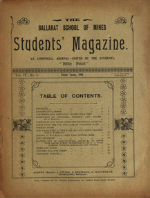
Booklet, Ballarat School of Mines, Student Magazine, Third Term, 1901, 1901
Articles include: Concentrating difficult silver-lead ores, Estimation of chlorine, bromine and iodine (by D.Runting. Summaries and notes from the technical journals, Notes upon the use and care of platinum ware, Common sense, The machinery at the Tasmania gold mine, Beacons-Field, Tasmanina, Mining at Walhalla - The long tunnel mine, Past students, Mapping out of agricultural areas &c., in dense vine lands, North Queensland (by R. A. Suter. Licensed surveyor, Queensland and Victoria), News and notes, Concert balance sheet, Editorial notices.Soft covered magazine of 16 pages. silver-lead ores, estimation of chlorine, bromine and iodine (by d.runting), platinum ware, tasmania gold mine, beaconsfield, tasmania, mining at walhalla, long tunnel mine, vine lands, north queensland, r. a. suter, photography class, boer war, alumni, thomas vincent, basil sawyer, o. e. jager, a. s. burdekin, t. phillipson, glen macpherson, tom uthwatt, marcus marks, r. j. allen, cecil eales, cecil wakley, adam morton, e.p. lewers, harry leggo, jack hill, berk, nickolls, h. burrows, percy osborne, j. brangan, chris evans, adamson, alford, r. evans, arthur "thomas" atkins, charles campbell, hardy, a. basil reid, h. l. krause, k. grant, m. gray, a.b. reid, h. alston, playford, j. a. reid, s. b. vial, f. a. marriott, f. lush, c. whyte, karl moore, r. robin, w. j. lakeland, e. trend, h. l. giles, r. mccracken, k. bryron moore -
 Kew Historical Society Inc
Photograph - 'Fernhurst', 13 Fernhurst Grove, 1978
George Wharton arrived in Melbourne in 1844. An architect and surveyor, he was appointed to lay out the 'Village of Kew' by N.A. Fenwick following the land sales of 1851. A protagonist for Kew's separation from the Boroondara District Road Board, he was elected chairman when Kew achieved municipal status in December 1860. His home, 'Fernhurst', was built in 1866 on eight acres in Studley Park, with a four-storey tower and pyramidal roof. The Italianate home was a prominent Kew landmark. It was demolished in 1979 and replaced by St Paul's College in 1980.Rare colour photograph of what was once a significant mansion in Kew.Original colour positive photograph (Kodak print) of 'Fernhurst' in 1978. Photographed by Stewart West in May 1978, one year before it was demolished, the photograph gives little idea of the large landholding once surrounding the house. Originally accessed from near the corner of Princess Street and Studley Park Road, its gardens had been subdivided in the 1900s and its footprint restricted to 13 Fernhurst Grove. Like many other grand houses, by the 1970s it had been converted into apartments. From the photograph, one can see that the house had retained many of its original features such as the distinctive tower and the wide bow-fronted verandah. The slates on the roof (apart from those on the tower) had been replaced by tiles and the cement render of the exterior painted white. Annotated reverse: "View of Fernhurst Home Taken from Street / 10"fernhurst, 13 fernhurst grove -- kew (vic.), george wharton, italianate architecture, vila maria society, st paul's school for the blind -
 Kew Historical Society Inc
Photograph - 'Fernhurst', 13 Fernhurst Grove, 1978
George Wharton arrived in Melbourne in 1844. An architect and surveyor, he was appointed to lay out the 'Village of Kew' by N.A. Fenwick following the land sales of 1851. A protagonist for Kew's separation from the Boroondara District Road Board, he was elected chairman when Kew achieved municipal status in December 1860. His home, 'Fernhurst', was built in 1866 on eight acres in Studley Park, with a four-storey tower and pyramidal roof. The Italianate home was a prominent Kew landmark. It was demolished in 1979 and replaced by St Paul's College in 1980.Rare colour photograph of what was once a significant mansion in Kew.Original colour positive photograph (Kodak print) of 'Fernhurst' in 1978. Photographed by Stewart West in May 1978, one year before it was demolished, the photograph gives little idea of the large landholding once surrounding the house. Originally accessed from near the corner of Princess Street and Studley Park Road, its gardens had been subdivided in the 1900s and its footprint restricted to 13 Fernhurst Grove. Like many other grand houses, by the 1970s it had been converted into apartments. From the photograph, one can see that the house had retained many of its original features such as the distinctive tower and the wide bow-fronted verandah. The slates on the roof (apart from those on the tower) had been replaced by tiles and the cement render of the exterior painted white. Annotated reverse: "Fernhurst from higher ground level side shot / 7"fernhurst, 13 fernhurst grove -- kew (vic.), george wharton, italianate architecture, vila maria society, st paul's school for the blind -
 Kew Historical Society Inc
Photograph - 'Fernhurst', 13 Fernhurst Grove, 1978
George Wharton arrived in Melbourne in 1844. An architect and surveyor, he was appointed to lay out the 'Village of Kew' by N.A. Fenwick following the land sales of 1851. A protagonist for Kew's separation from the Boroondara District Road Board, he was elected chairman when Kew achieved municipal status in December 1860. His home, 'Fernhurst', was built in 1866 on eight acres in Studley Park, with a four-storey tower and pyramidal roof. The Italianate home was a prominent Kew landmark. It was demolished in 1979 and replaced by St Paul's College in 1980.Rare colour photograph of what was once a significant mansion in Kew.Original colour positive photograph (Kodak print) of 'Fernhurst' in 1978. Photographed by Stewart West in May 1978, one year before it was demolished, the photograph gives little idea of the large landholding once surrounding the house. Originally accessed from near the corner of Princess Street and Studley Park Road, its gardens had been subdivided in the 1900s and its footprint restricted to 13 Fernhurst Grove. Like many other grand houses, by the 1970s it had been converted into apartments. From the photograph, one can see that the house had retained many of its original features such as the distinctive tower and the wide bow-fronted verandah. The slates on the roof (apart from those on the tower) had been replaced by tiles and the cement render of the exterior painted white. Annotated reverse: "Back view of Fernhurst / 8"fernhurst, 13 fernhurst grove -- kew (vic.), george wharton, italianate architecture, vila maria society, st paul's school for the blind -
 Kew Historical Society Inc
Photograph - 'Fernhurst', 13 Fernhurst Grove, 1978
George Wharton arrived in Melbourne in 1844. An architect and surveyor, he was appointed to lay out the 'Village of Kew' by N.A. Fenwick following the land sales of 1851. A protagonist for Kew's separation from the Boroondara District Road Board, he was elected chairman when Kew achieved municipal status in December 1860. His home, 'Fernhurst', was built in 1866 on eight acres in Studley Park, with a four-storey tower and pyramidal roof. The Italianate home was a prominent Kew landmark. It was demolished in 1979 and replaced by St Paul's College in 1980.Rare colour photograph of what was once a significant mansion in Kew.Original colour positive photograph (Kodak print) of 'Fernhurst' in 1978. Photographed by Stewart West in May 1978, one year before it was demolished, the photograph gives little idea of the large landholding once surrounding the house. Originally accessed from near the corner of Princess Street and Studley Park Road, its gardens had been subdivided in the 1900s and its footprint restricted to 13 Fernhurst Grove. Like many other grand houses, by the 1970s it had been converted into apartments. From the photograph, one can see that the house had retained many of its original features such as the distinctive tower and the wide bow-fronted verandah. The slates on the roof (apart from those on the tower) had been replaced by tiles and the cement render of the exterior painted white. Annotated reverse: "Fernhurst front view taken from across Fernhurst Grove / 6"fernhurst, 13 fernhurst grove -- kew (vic.), george wharton, italianate architecture, vila maria society, st paul's school for the blind -
 Kew Historical Society Inc
Photograph - 'Fernhurst', 13 Fernhurst Grove, 1978
George Wharton arrived in Melbourne in 1844. An architect and surveyor, he was appointed to lay out the 'Village of Kew' by N.A. Fenwick following the land sales of 1851. A protagonist for Kew's separation from the Boroondara District Road Board, he was elected chairman when Kew achieved municipal status in December 1860. His home, 'Fernhurst', was built in 1866 on eight acres in Studley Park, with a four-storey tower and pyramidal roof. The Italianate home was a prominent Kew landmark. It was demolished in 1979 and replaced by St Paul's College in 1980.Rare colour photograph of what was once a significant mansion in Kew.Original colour positive photograph (Kodak print) of 'Fernhurst' in 1978. Photographed by Stewart West in May 1978, one year before it was demolished, the photograph gives little idea of the large landholding once surrounding the house. Originally accessed from near the corner of Princess Street and Studley Park Road, its gardens had been subdivided in the 1900s and its footprint restricted to 13 Fernhurst Grove. Like many other grand houses, by the 1970s it had been converted into apartments. From the photograph, one can see that the house had retained many of its original features such as the distinctive tower and the wide bow-fronted verandah. The slates on the roof (apart from those on the tower) had been replaced by tiles and the cement render of the exterior painted white. Annotated reverse: "Front view of Fernhurst showing tower to advantage / 9"fernhurst, 13 fernhurst grove -- kew (vic.), george wharton, italianate architecture, vila maria society, st paul's school for the blind -
 Kew Historical Society Inc
Photograph - 'Fernhurst', 13 Fernhurst Grove, 1978
George Wharton arrived in Melbourne in 1844. An architect and surveyor, he was appointed to lay out the 'Village of Kew' by N.A. Fenwick following the land sales of 1851. A protagonist for Kew's separation from the Boroondara District Road Board, he was elected chairman when Kew achieved municipal status in December 1860. His home, 'Fernhurst', was built in 1866 on eight acres in Studley Park, with a four-storey tower and pyramidal roof. The Italianate home was a prominent Kew landmark. It was demolished in 1979 and replaced by St Paul's College in 1980.Rare colour photograph of what was once a significant mansion in Kew.Original colour positive photograph (Kodak print) of 'Fernhurst' in 1978. Photographed by Stewart West in May 1978, one year before it was demolished, the photograph gives little idea of the large landholding once surrounding the house. Originally accessed from near the corner of Princess Street and Studley Park Road, its gardens had been subdivided in the 1900s and its footprint restricted to 13 Fernhurst Grove. Like many other grand houses, by the 1970s it had been converted into apartments. From the photograph, one can see that the house had retained many of its original features such as the distinctive tower and the wide bow-fronted verandah. The slates on the roof (apart from those on the tower) had been replaced by tiles and the cement render of the exterior painted white. Annotated reverse: "Fernhurst corner shot through trees / 12-22"fernhurst, 13 fernhurst grove -- kew (vic.), george wharton, italianate architecture, vila maria society, st paul's school for the blind