Showing 913 items
matching the rocks
-
 Williamstown Botanic Gardens- Hobsons Bay City Council
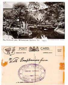
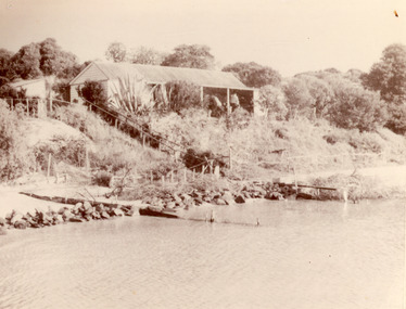
Postcard – Williamstown Botanic Gardens, The Crown Studios, Sydney, c1900-1920
The lake was built in 1904, during the curatorship of Mr Thake. Lee Heap Furniture Warehouse of Williamstown used the postcards to advertise. The postcards are evidence of the interest the gardens held as a subject for postcard publishers. The text and images provide a snapshot into fashions, social interests and concerns of the time. The professionally produced images provide a pictorial history of Gardens including changing planting styles, various structures and features of the Gardens eg the aviary, cannons, the fountain, the second Curator’s Lodge and gates. The images offer an opportunity to compare garden vistas with the present day.Sepia image of the ornamental lake and part of the Curator’s Lodge in the background on the left side of card. The small island with a succulent is in the centre of the image with a similar plant on the right side of it. The water is edged with rocks. Reflections of the plantings and lodge can be seen.Front: ‘The Artificial Lake, Williamstown Gardens. Vic.’ ‘0457/3’ ‘THE CROWN STUDIOS, SYDNEY’. Reverse: Centre top ‘POST CARD’ with a logo in the middle of the words. Left top corner a drawing of an artist’s board and brushes with a camera in the centre. Left side ‘MESSAGE ONLY.’ Right side ‘ADDRESS ONLY.’ Top right corner inside a dotted rectangle ‘STAMP HERE’. Bottom on card ‘BY THE CROWN STUDIOS, SYNDEY.’ Under the vertical line down the middle line ‘Neither the Address not the Message must cross this line’. In ink ‘With Compliments from’. An oval stamp with scalloped rim ‘LEE HEAP FURNITURE MANUFACTURER’ inside inner oval ‘FURNITURE WAREHOUSE, / WILLIAMSTOWN’.postcard, gardens, post-card, williamstown-botanic-gardens, hobsons-bay-city-council, ornamental lake, crown studios, lee heap furniture warehouse -
 Clunes Museum
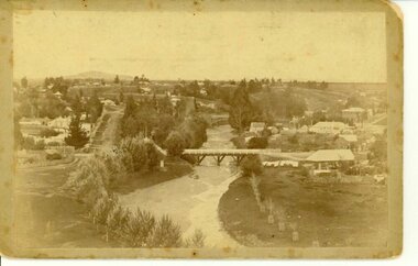
Photograph, BAWDEN PHOTOGRAPHER, CIRCA 1890
TULLAROOP CREEK FROM "ROCKS" NEAR SITE OF PORT PHILLIP MINE. ABOUT 1890 - NOTE GOVERNMENT BRIDGE IN DISTANCE. THIS WAS REBUILT IN STRAIGHT STEEL GIRDERS IN 1896.ORIGINAL SEPIA PHOTOGRAPH OF TULLAROOP CREEK, IN FOREGROUND VIEWS OF CLUNES TOWNSHIP. TWO MILE HILL IN LEFT FAR DISTANCE. (SUSPENSION BRIDGE IN FOREGROUND)local history, photography, bridges - buildings and landscape of clunes -
 Peterborough History Group
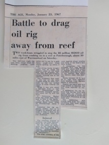
Newspaper - Battle to drag oil rig away from reef
Demonstrates that gas and oil exploration has been occurring for at least 50 years. This records an incident involving an oil rig becoming detached and drifting on the rocks near Peterborough.Significant as it records an incident involving an oil rig becoming detached and drifting on the rocks near Peterborough. This was quite an event, and an eyewitness recalls how high and startlingly close the lights of the drifting rig appeared to be to the town. In daylight the rescue of the rig was an entertainment for the residents and holidaymakers.Photocopy of a two column article about an incident involving an oil rig.peterborough, oil rigs, marine rescue -
 Bendigo Military Museum
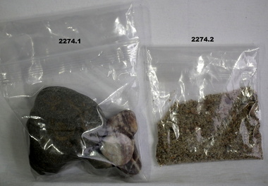
Souvenir - SOUVENIRS, ANZAC COVE, Post 1990
.1) Four rocks of various size from the beach on Anzac Cove .2) Sand from the beach at Anzac Cove .3) Cone from an aleppo pine grown on Gallipoli .4) Small round pine cone from Gallipolianzac, pines, minerals, souvenirs -
 Glenelg Shire Council Cultural Collection
Photograph - Photograph - Cape Grant Quarry, n.d
Port of Portland Authority ArchivesBack: Quarry\, June 8th - top left, pencilport of portland archives, cape grant quarry -
Bendigo Historical Society Inc.
Artwork,other - AILEEN AND JOHN ELLISON COLLECTION: CHARCOAL SKETCH OF EUCALYPTS
Framed charcoal sketch, original, buff surround. Image shows stand of eucalypts on RH side, rocks in background. On bottom of artwork, printed, D.H.30. Artist unknown. On back of painting, 'Merryn' and 'property of L.J. Ellison' written in pen.unknownperson, bendigo, aileen and john ellison -
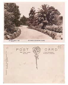 Williamstown Botanic Gardens- Hobsons Bay City Council
Postcard - Williamstown Botanic Gardens, c1900 - 1920
The original postcards in this series (2013.002 to 2013.018) were generously loaned to Williamstown Botanic Gardens by a private collector for copying. The postcards are evidence of the interest the gardens held as a subject for postcard publishers. The text and images provide a snapshot into fashions, social interests and concerns of the time. The professionally produced images provide a pictorial history of Gardens including changing planting styles, various structures and features of the Gardens eg the aviary, cannons, the fountain, the second Curator’s Lodge and gates. The images offer an opportunity to compare garden vistas with the present day. This postcard is evidence of the location of one of the cannons relocated from Fort Gellibrand in 1906. They were removed from the Gardens in the 1960s. These same cannons remain a feature on the Williamstown waterfront in 2013. A sepia postcard depicting a winding path lined with rocks. There is a cannon on the right hand side of the card beneath a spreading palm tree. There is a tall pine and a cypress tree in the background. The cannons were relocated from Fort Gellibrand to the Gardens in 1906. Front: ‘THE ROSE SERIES, P. 1030 THE GARDENS, WILLIMASTOWN, VICTOORIA / copyright’. Reverse: Left side vertical ‘Published by the Rose Stereograph Co. / Armadale, Victoria’. Across the top of the card: ‘POST CARD / The “Rose” Series A Real Photograph / De Luxe Produced in Australia’. There is an image of a rose and stem with three leaves in the centre of the card. In pencil on top right hand corner: $5 [believed to be inserted by the vendor of the card]postcard, gardens, post-card, williamstown-botanic-gardens, hobsons-bay-city-council, garden-path, cannon, rose stereograph, rose-series, 1906 -
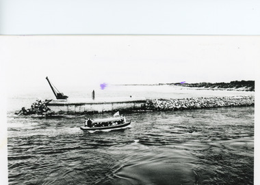 Lakes Entrance Historical Society
Photograph - The Entrance, 1920c
Black and white photograph showing entrance to Gippsland Lakes from ocean - Bass Strait. Photo shows rebuilt western pier with crane on end of pier, loose rocks. Launch - possibly Peels 'Blackbird' in the entrance. Lakes Entrance Victoria boats and boating, tourism, waterways, piers -
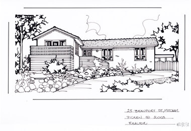 Whitehorse Historical Society Inc.
Artwork, other - Ink Line Drawing, Margaret Picken, 25 Beaufort St., Mitcham, 2003
A property illustration by Margaret Picken Commissioned by a real estate agency for the purpose of advertising 25 Beaufort St., Mitcham. This property has be listed as having sold for $309,000 in 2003. Made by using Rotring ‘Rapidigraph’ drafting pens with Rotring ink on Rapidigraph polyester drafting film, double matte. Trained as a cartographic draftsman within the mining industry, Margaret Picken is an artist who worked producing property illustrations for real estate agencies in eastern suburbs of Victoria from 1983-2005. Retiring from the industry as technological changes favored coloured photography over illustrations, and commissioning companies over sole contractors.This artwork is of Historical Significance as a record of local domestic architecture.A black ink line drawing on drafters film by Margaret Picken, of 25 Beaufort St., Mitcham depicting a L shaped brick house, set back from a front garden with feature rocks, and a winding driveway leading to a gate on the right.25 Beaufort St., Mitcham Picken © 2003 Realtorwhitehorse historical society, schwerkolt cottage, housing, architecture, margaret picken, house, garden, real estate, mitcham -
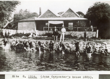 Lakes Entrance Historical Society
Photograph - Carpentertown, Sale, 1916c
Girls in water are in neck to knee swim suitsBlack and white photograph showing twin gable Carpenter House on dunes at New Works. Nine girls at waters edge preparing to swim, and two men and child on rocks. Picket fence across front of house. Lakes Entrance VictoriaSite 8 1916 (John Carpenter's house 1889) photo: W. Thomson, Clydebank, Sale. houses, waterways, recreation -
 Lakes Entrance Historical Society
Photograph, 1954
Black and white photograph showing rough water lashing foreshore west of entrance, walings and crane middle distance on right, waves splashing on rocks in foreground, photo taken near Schnapper Cottage, Hopetoun channel, Lakes Entrance, Victoria.jetties, waterways -
 Lakes Entrance Historical Society
Postcard - S.S. Gippsland, 1925 c
Black and white small format postcard showing SS Gippsland approaching Kalimna Jetty, Jemmys Point in background, small boat behind the Gippsland, one man fishing from rocks, a few people on jetty. Lakes Entrance VictoriaJemmys Point, Lakes Entrance (on back)ships and shipping, waterways, jetties -
Lakes Entrance Historical Society
Book, M Holding, Inquest Mining Accidents, 2010
A folder containing inquests inquiries into accidental deaths associated with various types of mining. James Roadknight taking rocks from Granite Rock for entrance works, Francis William Robinson delivering supplies to oil bure and Thomas Douglas Hollingsmines and mining, oil and gas industry, construction -
 Eltham District Historical Society Inc
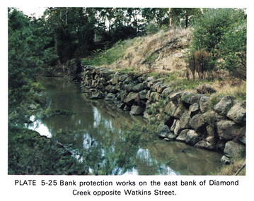
Work on paper (Sub-Item) - Photograph, Bank protection works on the east bank of Diamond Creek opposite Watkins Street
Colour photograph of bank protection works, using bluestone rocks to construct a wall on the east bank of Diamond Creek, to prevent erosion. Opposite Watkins Street, Diamond Creek townshipeltham, drain, diamond creek, erosion, watkins street, protection, bluestone, wall -
Glenelg Shire Council Cultural Collection
Photograph - Photograph - Blacknose Quarry, 30/06/1953
Port of Portland Authority ArchivesBack: Purple PHT stampport of portland archives -
Clunes Museum
Tool - GOLD CRADLE & PANNING DISH, JAMES ESMOND, CIRCA 1850
USED TO OBTAIN ALLUVIAL GOLD THE DESIGN OF THIS EQUIPMENT IS MOSTLY BASED ON THE PRINCIPLE OF THE WAY HEAVY MINERALS ARE CONCENTRATED IN ALLUVIAL DEPOSITS. THE PROSPECTING DISH IS USED WHEN WORKING WITH SMALL AMOUNTS OF STONES & CLAY WHILE BIGGER JOBS THE CRADLE OR BANJO IS MORE EFFICIENT. THE GAUZE OF MESH IN THE SIEVE IS VARIABLE. THE CRADLE OR BANJO IS USUALLY SET UP AT RIGHT ANGLES TO A SHALLOW CREEK OR WATERHOLE WITH THE OPEN ENDS TOWARDS THE WATER.1 WOODEN CONSTRUCTION MADE BY HAND WITH GAUZE FILTER IN UPPER SECTION TO SEPARATE QUARTZ ROCKS, SAND AND SOIL. A HANDLE ON BOX LIKE CONSTRUCTION IS USED TO ROCK THE CRADLE WHICH IS MOUNTED WITH ITS ROCKERS RESTING ON WOODEN BEARERS. .2 PANlocal history, mining equipment, mining -
Clunes Museum
Photograph
FIVE PHOTOGRAPHS OF HISTORIC CLUNES. FIVE VIEWS FROM THE PAST. 1.CLUNES IN THE EARLY SIXTIES, 2. TOWNSHIP OF CLUNES FROM THE ROCKS, 3. CLUNES HOSPITAL,4.CLUNES TOWN HALL AND COURT HOUSE, 5. BUTTER FACTORY, CLUNES.local history, photographs, clunes buildings -
 South Gippsland Shire Council
Photograph, Framed, Monbulk Creek - Belgrave
Framed colour photograph titled "Cardinia Reserve". The image features a pink sky (sunrise or sunset) reflected in the waters of Cardinia Reserve. Rocks in the foreground, low hills and trees on the horizon. Green card window mount set in black metal frame. -
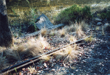 Lakes Entrance Historical Society
Photograph - Tramline, 1977
This photograph was used in the 150 year Lakes Entrance 1858-2008 display.Color photograph of a remnant of the tramway which ran from the Mississippi Creek quarry, to the head of the North Arm. It shows two lengths of iron rail, two large rocks and some smaller pieces beside the swampy creek. Lakes Entrance Victoria public works, transport, historic site -
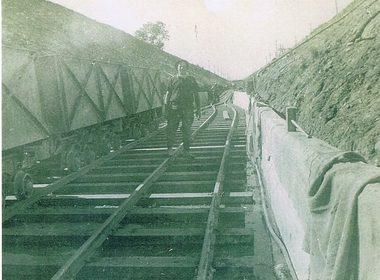 Kiewa Valley Historical Society
Photograph KHS Rail, Kiewa Hydroelectric Scheme Railway, Circa1940s
This photograph shows part of the railway constructed and used for the removal of soil and rocks from the tunnels bored out of the mountains for the pipeline servicing the Hydro Electricity power stations in the Kiewa Hydroelectric Scheme. This photo details an era when there were 4,000 construction workers located in two main accommodation camps, Mount Beauty (the larger one) and Bogong village. These accommodation sites were constructed and maintained as a secured or gated residential area with access only available by a special pass authorised by the Kiewa Hydroelectric Scheme. All the power used by the rail system was from electric motors connected to batteries. Overhead power poles seen on either side of the embankment details that electricity from the Scheme was in use. This use was cleaner and more environmentally friendly than the coal still used by large locomotives from city to country railways. The worker shown is not however wearing protective head and hand coverings. This is also an era where there was a lack of health and safety legislation covering workers in dangerous working conditions.Scanned photo of original black and white photo on Kodak XtraLife II paper. Picture is of a section of railway track servicing the tunnels of the Hydroelectric scheme during the 1940s - 1950sOn back of photo "Kodak XtraLife II paper"railway in kiewa electric scheme, tunneling -
 Phillip Island and District Historical Society Inc.
Photographs, 1939
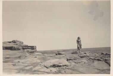
A group of 26 photographs collected by Ralph Andrews, father of Michele Spencer donor. Michele sent the photographs with a covering letter explaining how her father had kept to collection for many years so she felt they should go to a good home for safe keeping. Michele's husband's uncle, Frank Spencer, was the Post Master at Cowes for many years.219-01. Photograph of lady standing on rocks at San Remo 219-02. Photograph of rocks at Back Beach San Remo 219-03. Photograph of rocks at Back Beach San Remo 219-04. Photograph of the San Remo Camping Ground 219-05. Photograph of Merv Horkings in tent at San Remo Camping Ground 219-06. Photograph of Merv Horkings in tent at San Remo Camping Ground 219-07. Photograph of three men on the beach at San Remo 219-08. Photograph of coastal scene San Remo at low tide 219-09. Photograph of rocks at San Remo 219-10. Photograph of shoreline with trees at San Remo 219-11. Photograph of Jetty at San Remo with boats moored 219-12. Photograph of the back view of a man on the beach at San Remo 219-13. Photograph of coastal scene looking towards the eastern entrance to Westernport 219-14. Photograph of Merv Horkings standing outside a tent at the San Remo Camping Ground 219-15. Photograph of people standing and sitting on rocks at San Remo 219-16. Photograph of coastal scene looking towards the eastern entrance to Westernport 219-17. Photograph of foreshore with rocks and lonely tree on land at San Remo 219-18. Photograph taken from San Remo looking towards Newhaven with breakwater. 219-19. Photograph of rock platform at San Remo 219-20. Photograph of coastal scene at San Remo 219-21. Photograph of the breakwater at San Remo 219-22. Photograph of a man sitting on the beach at San Remo with groyns on the foreshore 219-23. Photograph of coastal scene at San Remo 219-24. Photograph of coastal scene at San Remo 219-25. Photograph of the San Remo Punt 219-26. Photograph of a vehicle waiting for the Punt to travel across to Newhavensan remo coastline, san remo punt, newhaven-san remo punt, san remo camping ground, ralph andrews, frank spencer, michele spencer -
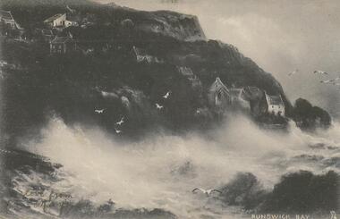 Bendigo Historical Society Inc.
Postcard - GLADYS DEAN COLLECTION: POSTCARD, 1906 - 1908
Coloured printed postcard. Image is of a black and white painting entitled 'Runswick Bay'. Image is of a steep cliff with houses and cottages above rocks. Waves are breaking over the rocks and gulls are flying over the waves and in the sky. The words Runswick Bay are printed in white along the lower right hand edge. On the reverse, it is addressed to Miss Dean McKenzie Street Golden Square with a one penny stamp affixed postmarked Bendigo. The words Raphael Tuck and Sons "Sapphire Rough Seas" Series 6307 Phototyped in Berlin "Whitby" Art Publishers to Their Majesties The King and Queen appear along the lefthand edge.Raphael Tuck and Sons 'Sapphire Rough Sea' Series 6307 'Whitby'postcard -
Glenelg Shire Council Cultural Collection
Map - Map - Portland, 1950s
White card with 2 maps of Portland; larger one showing the town and harbour, smaller one of town, Portland Bay, Bridgewater Bay, Nelson Bay, Lawrence Rocks. Also Portland phone numbers: Ambulance Hospital, Police, Fire, Taxi, Electricianmap, portland, portland harbour, cape bridgewater, south west coastline -
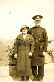 Federation University Historical Collection
Photograph - Black and White, Frank Wright and Mrs Gilmour, Morecombe, 1934, July 1934
Frank Wright was a renown resident of Smeaton, where he was born. He lived at Laura Villa, and attended Smeaton State School. His father William was a gold miner and his mother's name was Sarah. Their family won many singing and instrumental awards. Frank was tutored by Percy Code and was awarded a gold medal for the highest marks in the ALCM examinations in the British Colonies at the age of seventeen years. He became the Australian Open Cornet Champion by the age of eighteen. A year later, Frank conducted the City of Ballarat Band, and later the Ballarat Soldiers’ Memorial Band. He formed the Frank Wright Frisco Band and Frank Wright and his Coliseum Orchestra. These bands won many South Street awards, and Frank as conductor won many awards in the Australian Band Championship contest. In 1933 Frank Wright sailed to England to conduct the famous St Hilda’s Band and was later appointed Musical Director of the London County Council, where he organized many amazing concerts in parks, in and around the London district. He was made Professor of Brass and Military Band Scoring and conducted at the Guildhall of Music and Drama. Frank was often invited to adjudicate Brass Band Championships around Europe, in Australia, including South Street and in New Zealand. The Frank Wright Medal at the Royal South Street competition is awarded to an individual recognized as making an outstanding contribution to brass music in Australia.Black and white photograph of a man wearing a band uniform standing with his arm around a woman wearing a dark hat and overcoat.The background appears to be a rockery with plants growing between the rocks. The man is Frank Wright and the woman is Mrs Gilmour. The place is Morecombe.Written in pencil on the back - Frank Wright, Mrs Gilmour, Morecombe, July 1934 Printed on the back - 5 - 51frank wright, conductor, band uniform, mrs gilmour, morecombe -
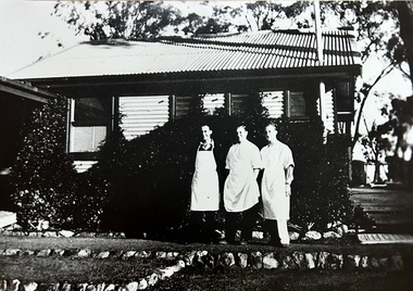 Tatura Irrigation & Wartime Camps Museum
Photograph - 28 Camp Hospital Store
The 28 Camp hospital store was opposite the camp kitchen. Pictured from left is an unknown Corporal, an unknown man, and Private Maher. Black and White photograph of three men standing in front of a corrugated iron building. The garden is lined with rocks with large trees behind the building. One man has a white apron on the other two are wearing white gowns that appear to be or similar to medical gowns.28 camp hospital, store, maher, danson -
 Wodonga & District Historical Society Inc
Album - Hume Reservoir Australia Album - Gravity incline for transport of rocks
This set of photos is from a leather bound album bearing the inscription "HUME RESERVOIR AUSTRALIA" plus 'The Rt. Hon. L. C. M. S. Amery, P. C., M .P.' all inscribed in gold. It was presented to The Rt. Hon. L. C. M. S. Amery, P. C., M. P, Secretary of State for Dominion Affairs on the occasion of his visit to the Hume Reservoir on 2nd November 1927. This album is of local and national significance as it documents the planning and development of the Hume Reservoir up to 1927. It was the largest water reservoir in the British Empire. The album records the pioneering engineering work that went into its construction.DEPARTMENT OF PUBLIC WORKS, N.S.W. RIVER MURRAY WATERS SCHEME. HUME RESERVOIR. 16. Gravity incline for transport of "plums" from Quarry, New South Wales. "Plums" were larger rocks which could be re-used for other construction purposes.hume reservoir australia, river murray waters scheme, hume reservoir construction -
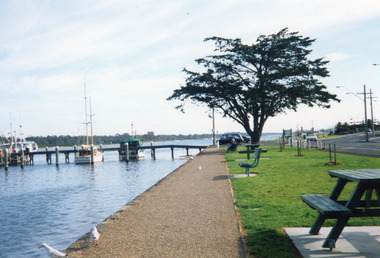 Lakes Entrance Historical Society
Photograph - Waterfront, 1999
Date made 10 April 1999Colour photograph of Esplanade and waterfront, it shows vessels moored at jetty, bluestone rocks edging path beside lake seats and picnic tables and newly planted trees on lawn verge of highway, jetty sign posted as Bank Jetty. Lakes Entrance Victoriajetties, waterfront, boats and boating -
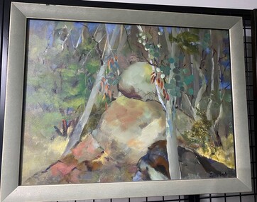 Glenelg Shire Council Cultural Collection
Painting, Julie Kent, Bailey's Rocks, n.d
Oil on canvas. Depiction of Baileys Rocks Casterton. Stacked circular shaped boulders set in amongst a bush backdrop. Trunks of trees are ghost gum grey with various greenery and hints of a blue sky through the trees. Yellow spatters in the in the bottom right quadrant. Black signature bottom right corner. 'Julie Kent' -
 Lakes Entrance Historical Society
Photograph - Sea Shell Cottage, 1920c
One black and white enlarged copy 19.5 x 25.5Sepia photograph showing New Works cottage Sea Shell on dunes, people on verandah, shed back left of house, rocks and wooden groynes along beach front, fence and track down side of house. Vegetation on dunes. Lakes Entrance Victoriawaterfront, houses, vegetation -
 The Beechworth Burke Museum
Geological specimen - Fossil Leaves
A fossil refers to any remains or traces of past life that are preserved in the rock. It could be remains of plants or animals. Fossil leaves are commonly found on different types of rocks. These fossils can go as far back as the Triassic Age just like the series of fossil plants collected at Denmark Hill, Ipswich in Queensland. Fossils leaves are formed when dead plants get buried by sediments like mud, sand, or volcanic ash. Often, it gets detached cleanly from stems along a special layer of weak cells, then twigs, and, less commonly, cones of conifers and fruits and seeds of flowering plants. Over time, the leaves or pieces of leaves get buried by more sediments and eventually gets 'lithified' or hardened into a rock. Erosions and mining can cause the rocks to break and reveal the fossils buried in it. Fossilisation frequently takes place at sites in the lowlands where deposits of clay, silt, sand are found. This is usually due to weathering and erosion of rocks. Fossil leaves can provide information about ancient Australia's way of living. It contributes to Victorian biodiversity records and its botanical collections. It also contributes information on the geographical profile of Victoria as fossilisation usually occur at estuaries and deltas of rivers, river flood plains, ponds and lakes. This specimen is part of a larger collection of geological and mineral specimens collected from around Australia (and some parts of the world) and donated to the Burke Museum between 1868-1880. A large percentage of these specimens were collected in Victoria as part of the Geological Survey of Victoria that begun in 1852 (in response to the Gold Rush) to study and map the geology of Victoria. Collecting geological specimens was an important part of mapping and understanding the scientific makeup of the earth. Many of these specimens were sent to research and collecting organisations across Australia, including the Burke Museum, to educate and encourage further study.Piece of light brown rock with fossilised leaves in shades of golden yellow and brown.Existing label: Fossil Leaves / Locality unknown / might be worth checking if this is Glossopteris, a Permian age plant. / C. William 16/4/21 geological specimen, geology, geology collection, burke museum, beechworth, fossil leaves, fossilization, 1868 geological survey of victoria, lithified, rocks, fossilised leaf, rock, fossils, leaves