Showing 2471 items matching " township"
-
 Hume City Civic Collection
Photograph
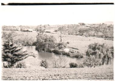
A b/w photograph of a landscape view showing Jackson's Creek with the Sunbury township in the background.Handwritten on back: McMahonmcmahon, landscapes, jackson's creek, sunbury, george evans collection -
 Clunes Museum
Document - POSTCARD AND REPORT, UNKNOWN
POSTCARD OVERVIEW OF CLUNES TOWNSHIP, TOGETHER WITH A BRIEF REPORT REGARDING THE CLUNES POST OFFICElocal history, documents, reports, postcards, clunes post office, clunes township -
 Ballarat Heritage Services
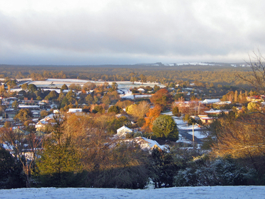
Photograph - Digital photographs, L.J. Gervasoni, View of Daylesford in Snow from Wombat Hill Botanic Gardens, c2012-2016
Daylesford is a Central Victorian town. Colour photograph from the Wombat Botanical Gardens showing snow covering the township of Dayelsford. daylesford, snow, weather, climate, winter, daylesford botanic gardens, botanic gardens, wombat hill, wombat hill botanic gardens, cityscape, viewscape -
 Falls Creek Historical Society
Postcard - Mt. Beauty, Victoria
These photographs were taken in and around Mount Beauty and the Kiewa Valley by Samuel Keith Pearce and printed for him as a foldout postcard by NuColor Vue. The postcards state they were printed for S. K. Pearce Pty. Ltd of Tawonga and Mount Beauty. Samuel Keith Pearce was born on 24 June 1917 in Armadale, Victoria. By the late 1940s he owned the Mt Beauty Supermarket, Newsagency, Drapery and Hardware store at Mount Beauty and also a store at Tawonga in partnership with his brother Gordon Cathew Pearce. For some time, they operated as Pearce Brothers. In the early 1960s Keith also opened a mini mart In Falls Creek. As well as being a keen photographer and an astute businessman, Keith Pearce was a well-known identity in the Kiewa Valley, making many contributions to the development of the area over a long period. This included serving as a member of the Bright Shire Council for many years. He worked hard to promote the interests of the Upper Kiewa Valley. As a sign of recognition and appreciation for his contribution to the community, the park opposite the grocery store in Mount Beauty was named the SK Pearce Gardens in his honour. Samuel Keith Pearce died on 7 July 1994 in Mount Beauty, Victoria Mt. Beauty at the head of the Kiewa Valley was established by the State Electricity Commission during the development of the Kiewa Hydroelectric Scheme. It forms the gateway to the Bogong High Plains, and is a popular centre for holiday makers in the north-east providing accommodation and access to excellent fishing grounds and, in winter, to the popular ski slopes of nearby Falls Creek.This collection of postcards and images is significant because they were commissioned by a highly successful businessman in Falls Creek, Victoria.A colour image of Mt. Beauty Township and Mt. Bogong from Power Line Lookout.mt. beauty, s. k. pearce -
 Wodonga & District Historical Society Inc
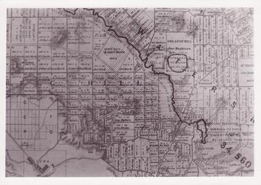
Map - Boorgunyah - "The Town that never was"
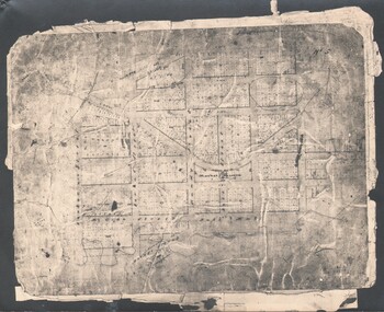
At the height of the river trade, there was a town surveyed and laid out, and streets were named. This town was to house the workers at the river port of Red Bank when the paddle steamers plied the Murray River as far as Albury, carrying produce such as wool and wheat to the various towns along the river in the 1800s. As the river trade died away, this town never went ahead – one might say, “The town that never was.” A lone gum tree stands on the site today.This item is significant because it documents plans which were made for the early development of Wodonga.A black an white map depicting the proposed location of the township. The map is based on a sketch and is not to scale,early wodonga, boorgunyah - "the town that never was", wodonga heritage -
 Clunes Museum
Document - MAP
PHOTO COPY. WATERSHED DAMS WEIR CREEK FOR THE COLLECTION OF WATER FOR THE CLUNES TOWNSHIP AND MINES.local history, photography, photographs, water supply -
 Lakes Entrance Historical Society
Postcard - Pyramid Rock Buchan Victoria, 1940 c
Black and white postcard showing the mountains in distance beyond the valley and township of Buchan Victoriafarming, topography, settlement -
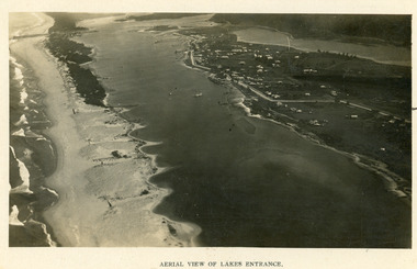 Lakes Entrance Historical Society
Photograph - Lakes Entrance, 1923c
Two copies 16.5 x 25.5 very darkBlack and white photograph showing early aerial view of township of Lakes Entrance, photo shows highway going along Myer Street and along Roadknight Street, no shops in Myer Street appears to be no foot bridge, therefore taken prior to 1937, sparce vegetation on foreground dunes, four barriers built on dunes to stop erosion through sand, two masted sailing boat in lake. Bullock Island in distance appears very small, Snake Island of Rigby Island in centre distance. Lakes Entrance VictoriaAerial View of Lakes Entrancewaterways, coast, aerial photograph, islands, township -
 Orbost & District Historical Society
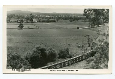
black and white photograph, Rose Stereograph Company, first half 20th century
The two bridges on the railway viaduct, which crosses the Snowy River floodplain at Orbost, were built from local Southern Mahogany. The bridge on the Bairnsdale end (770m) is now the longest in Victoria. Despite various attempts to extend the line, the station stayed on the western side of the Snowy River. (info. Helen Martin)This item is associated with the history of the Orbost-Bairnsdale railway line and therefore reflects the role that the rail line played in the social and economic history of Orbost.A black / white photograph / postcard of the Orbost township in the background and the railway viaduct over the flats in the foreground.photo caption - The Rose Series P.479 copywright SNOWY RIVER FLATS, ORBOST, VIC"east-gippsland-railway orbost-viaduct -
 Orbost & District Historical Society
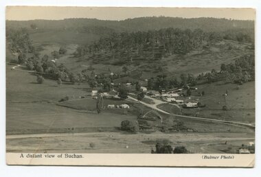
black and white photograph, Howard D. Bulmer, first half 20th century
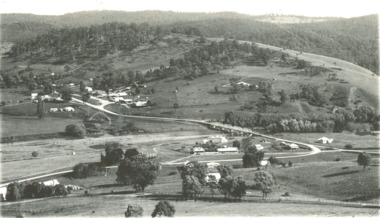
This is a pictorial record of Buchan in the first half of the 20th century.A black / white photograph / postcard of a township in a valley. The photograph has been taken from a distance.on front - A Distant View of Buchanbuchan -
 Federation University Historical Collection
Book - Street Directory, Arnall & Jackson Pty Ltd, Victorian Municipal Directory and Gazatteer, 1939, 1939
Beige cover with blue spine. 1052 pages. It includes an index to townships, parishes and Railway stations. non-fictionvictorian municipalities, municipal, councils, water supply, advertisements, aboriginal protection board, agriculture, charities, county court, crown lands and survey, engine drivers board, licensing court, sludge abatement board, cities, towns, boroughs, ballarat, buninyong, gordon, grenville, talbot, traralgon, ballaarat, happy valley, bungaree, daylesford, glenlyon, glenlyon shire, hepburn springs -
Federation University Historical Collection
Book - Directory, Arnall & Jackson Pty Ltd, Victorian Municipal Directory and Gazatteer, 1935, 1935
Brown cover with maroon spine. 801 pages. It includes an index to townships, parishes and Railway stations. non-fictionvictorian municipalities, municipal, councils, water supply, advertisements, aboriginal protection board, agriculture, charities, county court, crown lands and survey, engine drivers board, licensing court, sludge abatement board, cities, towns, boroughs, ballarat, buninyong, gordon, grenville, talbot, traralgon, ballaarat, happy valley, bungaree, daylesford, glenlyon, glenlyon shire, hepburn springs -
Federation University Historical Collection
Book - Directory, Arnall & Jackson Pty Ltd, Victorian Municipal Directory and Gazatteer, 1924, 1924
Brown cover with blue spine. 708 pages. It includes an index to townships, parishes and Railway stations. non-fictionvictorian municipalities, municipal, councils, water supply, advertisements, aboriginal protection board, agriculture, charities, county court, crown lands and survey, engine drivers board, licensing court, sludge abatement board, cities, towns, boroughs, ballarat, buninyong, gordon, grenville, talbot, traralgon, ballaarat, happy valley, bungaree, daylesford, glenlyon, glenlyon shire, hepburn springs -
 Phillip Island and District Historical Society Inc.
Photograph
One of a collection of over 400 photographs in an album commenced in 1960 and presented to the Phillip Island & Westernport Historical Society by the Shire of Phillip IslandPhotograph of ladies and gentlemen on the Cowes Jetty taken looking along the trolley line towards the township.local history, photography, cowes jetty, black & white photograph, trolley line, cowes pier phillip island, john jenner, bryant west -
Glenelg Shire Council Cultural Collection
Postcard - Postcard - Suspension bridge Casterton, 1900-1930
SOURCED FROM CASTERTON TOWN HALL (FORMER SHIRE OF GLENELG) Sourced from Casterton Town Hall (Former Shire of Glenelg)Postcard, black and white,, showing the suspension bridge at Casterton, view across river towards townshipFront: 'SUSPN BRIDGE CASTERTON' Back: Handwritten correspondence, addressed to 'Miss M. Sythaleigh, Henty St Casterton' -
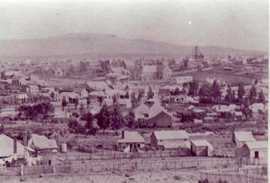
 Bendigo Historical Society Inc.
Photograph - CASTLEMAINE GAS COMPANY COLLECTION: PHOTO MALDON
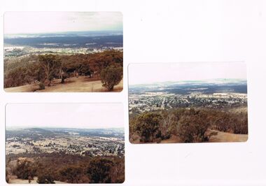
3 photos of the township of Maldon taken from the tower located on Mt Tarrengower overlooking the town.Kodakplace, landscape view, maldon -
 Bendigo Historical Society Inc.
Photograph - WES HARRY COLLECTION: TOWNSHIP OF SANDHURST, 1854
Same photograph as the previous entry (2402.40). Written in biro on the reverse id: Township of Sandhurst 1854.place, bendigo, proposed township, sandhurst -
 Clunes Museum
Photograph
SEPIA PHOTOGRAPH OF CLUNES TOWNSHIP - showing Camp Hill and the Commercial Hotel. Mt Beckworth in distance. local history, photography, photographs, clunes township -
 Bendigo Historical Society Inc.
Document - GOLDEN SQUARE P.S. LAUREL ST. 1189 COLLECTION: PHOTO, 1900's
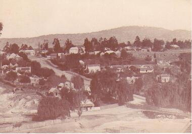
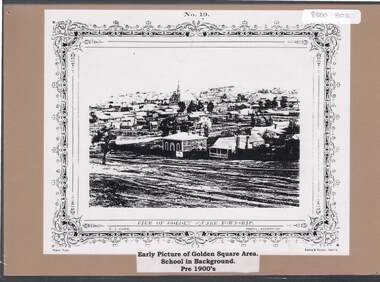
Copy of N.J. Caire print 'View of Golden Square township' mounted on light brown board.N.J. Caire, Photo Sandhurst. Forbes & Halmes, Agents.education, primary, golden square laurel st p.s., golden square township. -
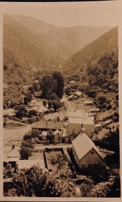 Kew Historical Society Inc
Postcard - Walhalla, 1920-25
Henry Christian (c.1809-91) was one of the first settlers in Kew. He arrived in Victoria with his wife Agnes and son Orlando in 1855 on the Gypsy Queen. He established a rope-making business in Bulleen Road by 1858 but was declared insolvent two years later. In his final years, he was celebrated as one of the oldest living settlers of the district. His son, Orlando Henry Beater Christian (c.1853-1930) became a member of the Hawthorn Band and a foundation member of the Willsmere Swimming Club. Orlando and his wife Elizabeth had four children: Henry Beater (1886-1962), Ada Susannah May (1888-1962), Orlando Julius (1891-1917) and Lilian Adelaide ( -1956).An item from an outstanding and diverse photographic collection, assembled by members of the Christian family of Pakington Street, Kew, comprising professional and amateur photography, depicting individuals, natural and settled environments and the interactions between these worlds. Many of the photographs vividly capture the worlds of three generations of men - Henry Christian, his son Orlando Henry Beater Christian, and his grandson of Henry Christian. The most important photographer was the youngest, Henry Christian, who was a keen explorer, not just of his immediate environment but also of the Victorian wilderness. His major opus is contained in two albums in which he records, sometimes in majestic detail and on other occasions the intimate features of the natural world. His photographic travels during the 1920s, often in solitary ramblings but on other occasions with companions, recall the heroic landscape photography of an earlier era, pioneered by Nicholas Caire. In addition to their aesthetic value, the albums are historically significant records within the State of Victoria, of what is now a distant point in time, and of places that have become radically altered through human intervention.Small sepia Kodak postcard of the Township of Walhalla, probably taken by the Kew photographer, Henry Christian. henry christian (1886-1962), landscape photography, walhalla -- victoria, christian-washfold collection -
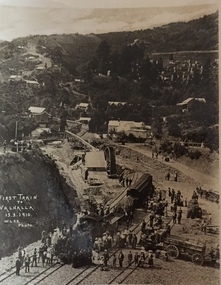 Kew Historical Society Inc
Postcard, M. Lee, First Train to Walhalla 15.3.1910, 1910
One of a number of 'real photo' and commercial postcards created by or owned by members of the Christian and Washfold families of Kew. The postcards are part of a larger collection of photographs, postcards and publications donated to the collection in May 2021.Small black and white postcard of the first train to Walhalla arriving in the township on 15 March 1910.First Train to Walhalla 15.3.1910. M. Lee Photohenry christian (1886-1962), landscape photography, trains -- walhalla -- victoria, christian-washfold collection -
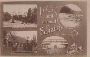 Sunbury Family History and Heritage Society Inc.
Post Card, In and around Sunbury with Greeting
The post card is one of a set that were produced by Chris Christainsen, who had a pharmacy in Sunbury and was also a photographer. The four photos featured on the card are the Rupertswood Mansion, St Mary's Church of England, Jacksons Creek in floods ands Sunbury Railway station.The buildings and places featured on the card are of historical significance in the Sunbury town precinct. A post card with four sepia photographs of interesting sites which can be seen in the Sunbury township. IN AND AROUND SUNBURY WITH GREETING. christainsen, chris., rupertswood mansion, st. mary's church of england., jacksons creek, sunbury railway station -
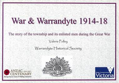 Ringwood and District Historical Society
Book, Valerie Polley, War & Warrandyte 1914-18 - Valerie Polley, 2016
The story of the township and its enlisted men during the Great War, by Valerie Polley, Warrandyte Historical Society.This book has been compiled from posters exhibited in the Warrandyte Historical Society's exhibition entitled War & Warrandyte 1914-18, made possible by a grant through the Anzac Centenary Community Grants (Veterans Fund) from the Victorian Government and the Victorian Veterans Council. -
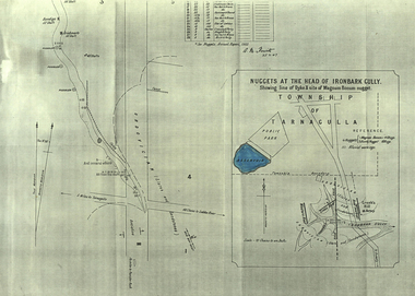 Federation University Historical Collection
Plan, A.M. Howitt, Nuggets at the Head of Ironbark Gully, Tarnagulla, c1907
Plan showing part of the township of Tarnagulla, and the Ironbark Gully area including Western Reef and Creek's Hill.tarnagulla, ironbark gully, western reef, creek's hill, cgt -
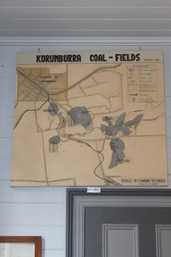 Coal Creek Community Park & Museum
Map of Korumburra's Coal, Korumburra Coal Fields, 1910
8513.1 - Map of coal fields, township, roads, creeks, railways and boreholes in the Korumburra area. Painted on Canvas -
 Clunes Museum
Photograph
BLACK AND WHITE PHOTOGRAPH OF CLUNES TOWNSHIP, TAKEN FROM LESLIE STREET EAST, OFF SMEATON ROAD.METHODIST & PRESBYTERIAN CHURCHES IN CENTRE TAKEN FROM LESLIE ST. EAST OF SMEATON ROAD NOTE WESLEYAN CHURCH HAS SPIRElocal history, photography, photographs, clunes township -
Linton and District Historical Society Inc
Purchase Document, Grant By Purchase, Special Land Sale,1861: Sale of land to Henry Franks
The Allotment was purchased as part of a sale of Special Lands at Linton on the 9th of April 1861 The amount paid was £16 15s.Photocopy of a document which records the purchase by H. Franks of Allotment 15, Section 1, Township of Linton. henry franks, allotment 15 section 1 township of linton, special land sale 1861, documents and records -
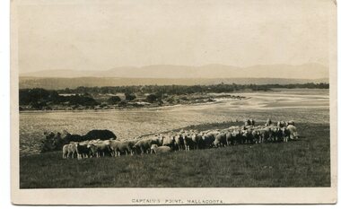 Orbost & District Historical Society
black and white photograph, first half 20th century
This photograph is of Captain's Point, Mallacoota.This is a pictorial record of Mallacoota in the first half of the 20th century. It shows the young township.A small black / white photograph / of a flock of sheep on a hilltop with the ocean behind them. A township can be seen in the background.on front - " Captain's Point Mallacoota"mallacoota-captains-point -
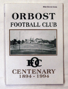 Orbost & District Historical Society
book, Orbost Football Club Centenary 1894 - 1994, 1994
This book was made for celebration of the centenary of the Orbost Football Club in 1994. The Orbost football club players were known as the Busters and wore green and gold guernseys. An Orbost football team has participated in the East Gippsland League since the early 20th century. In 2003 in response to a dwindling population, the Snowy Rovers and Orbost Football Clubs were driven to merge into the Orbost Snowy Rovers.Orbost Football Club through its many changes has always been an important social fabric of the Orbost community. Sport is often regarded as an important part of life in rural Australia, contributing to community identity, sense of place, social interaction and good health.A soft covered book of white with large green and gold print on the cover. There is a photograph of a football ovel with a township behind it.orbost-football-club-centenary recreation sport football -
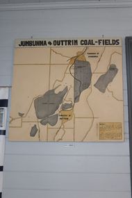 Coal Creek Community Park & Museum
Jumbunna Coal Field Map, Jumbunna and Outtrim Coal Fields, 1910
8512.1 - Map of coal fields, Township, roads rail lines and creeks in the Jumbunna and Outtrim areas. Painted on canvas.