Showing 594 items matching " underground"
-
 Kiewa Valley Historical Society
Photos: Kiewa Hydro Electric Scheme x 12
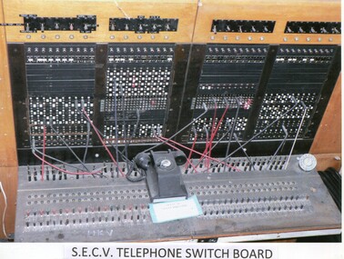
K.H.E.S.Photos 4 coloured and 8 black and white with the Title printed below each one. 1. S.E.C.V. Telephone Switch Board (See also KVHS 0847) 2.West Kiewa Tunnel 3. Construction of Underground Power Station 4. Pretty Vally Camp 5.Outside Kiewa House, Bogong 6. S.E.C.V. Saucer (See also KVHS 0128) 7.Insulator Disk Struck by Lightning 8. S.E.C.V. Map of the Kiewa Hydro Scheme 9.Howman's Gap Camp 10.Tunnel Excavation Face 11. Mt Beauty Townhship 1948, looking north east 12. Mt Beauty Township - no labelkiewa hydro electric scheme photos -
 Bendigo Historical Society Inc.
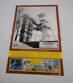
Document - CENTRAL DEBORAH GOLD MINE POSTER
Poster of central Deborah Gold Mine, Bendigo Victoria showing in black and white poppet head. Advertising: Bendigo goldmine open for inspection daily 10am - 5 pm guided tours by appointment phone 438070 or 436401. The Central Deborah gold mine, the last to close on the Bendigo field, was purchased early in 1970m by the Bendigo City Council for restoration and preservation as a typical Bendigo gold mine equipped with machinery , most of which was made in Bendigo. The Central Deborah Company was formed in 1939 to deepen an existing shaft sunk in 1912. Underground operations ceased in 1954. from 1942 to 1954 29,460 ounces of gold was won from 63,962 tons of ore.mine, gold, central deborah gold mine -
 Melbourne Tram Museum
Postcard, Murfett Publishers, W2 509 outbound in Wellington Parade Melbourne, early 1980's
Postcard - full colour, Divided back type of W2 509 outbound in Wellington Parade Melbourne. Two other trams are in the view. Tram has the destination of Kew Depot and route 29. In the background is a hoarding for the construction of the Melbourne Underground loop - indicates the photo taken late 1970's or early 1980's. Note the building on the corner of Spring and Flinders St, prior to the construction of Shell House mid 1980's. Note at this time Wellington Parade was only available for through motor traffic out of the city. published by National View by Murfett Publishers Australia. Has the details on the rear with place for stamp, address etc and logo.trams, tramways, wellington parade, kew depot, route 29, spring st, flinders st, tram 509 -
 Kiewa Valley Historical Society
Core Rock Samples
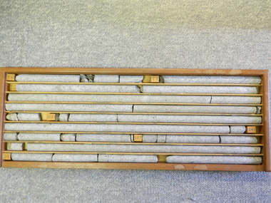
The core samples in the display cabinet were obtained from the various sites at which drilling into the rock surface was carried out (under the control of design and structural engineers of the SEC Kiewa Hydro Scheme - late 1940's). This function was a precursor to the decision where to locate, in this case, the McKay Creek Power Station. The information gained by structural engineers from the core samples would be used also for the placements of underground tunnels entry and exit points and the overall effective size of the generator plant. This would have included drill and blast techniques (rock characteristics play an import part of explosion control), requirements for support structures and reinforcing cement/steel forms. The use and replenishment of diamond drill bits(the strongest available, see KVHS 0280) was dependent on the "type" of rock found (harder rock required greater numbers of drill bits). Support beams for reinforced ceilings and floors was also a necessity.These rock core samples are very significant in the formulation and placement of the underground Power Stations and their maze of tunnels (in and out) for a successful implementation of the Hydro Scheme. The amount of pre-planning and engineering studies required for such a large scheme must be undertaken to ensure that a "white elephant" was not the result.There are nine columns of rock cores, each 30mm in diameter, set in a wooden display rack. A clear plastic (slide out) protective panel is installed to the front section. Within each column are block details of the depth from which that section was brought from. See KVHS for the appropriate sketch details.Depth levels (retrieved from) are shown for each section on wooden Blocks: 1st Block: "7'10" (seven feet, ten inches), 2nd Block:"9'4" (nine feet, four inches), 3rd Block: "19'3" (nineteen feet, three inches), 4th Block: "24'2" (twenty four feet, two inches), 5th Block: "25'7"( twenty five feet, seven inches) and last block: "30' (thirty feet)"alternate energy supplies, alpine feasibility studies temperature, rainfall, sec, kiewa hydro scheme, electricity -
 Melbourne Tram Museum
Document - Report, Australian Electric Traction Association (AETA), Set of 6 options for Doncaster Light Rail Line, 1991
In 1991, the Australian Electric Traction Association (AETA) produced 7 different options to provide public transport to the Doncaster area. See reference for background to the proposals. Six of the seven options have been found and collected. Each option provides a summary, costing based in a scope of works. The Options were: 1 - Light Rail to Doncaster Shoppingtown via Eastern Freeway/Doncaster Road 2 - Light rail to Mitcham Road/Springvale Road 3 - High-performance train to Doncaster Shoppingtown via Victoria Park station Eastern Freeway/Doncaster Road 4 - Heavy rail to Doncaster Shoppingtown via Eastern Freeway to Bulleen Road and underground to Shoppingtown 5 - Heavy Rail to Blackburn Road/George St East Doncaster 7 - Extension of the Camberwell Tram (72) along Burke Road from Cotham Road to Doncaster Road. Out of all the studies, nothing happened.Yields information about the early 1990s proposal to provide public transport to the Doncaster area.Set of 6 reports or options printed on A4 paper, stapled in top left hand corner.tramcars, tramways, aeta, new tramways, doncaster, railways, light rail -
 Bendigo Historical Society Inc.
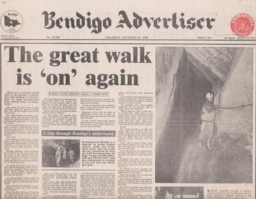
Newspaper - BENDIGO MINING, WALKING UNDERGROUND FROM SPRING GULLY TO EAGLEHAWK
Newspaper article, Bendigo Advertiser, Thursday October 13, 1988, page 1. It was said in the 'heyday of Bendigo's gold mining it was possible to walk underground from Spring Gully to Eaglehawk' Article describes a walk done in 1988 from the 8th level of the Central Deborah Gold Mine shaft (270 m) through a series of tortuous and at times hazardous drives, stopes, shafts and cross overs to the 8th level of the North Deborah Gold Mine. Steven Hinde, Bendigo Mining's Chief Geologist lead the trek, which proved it was still possible to go down one shaft and emerge up another. When Bendigo Mining dewatered the Central Deborah shaft it uncovered the old connecting passages.bendigo, mining, central deborah gold mine -
 Bendigo Historical Society Inc.
Document - FOR HISTORICAL SOCIETY BENDIGO BRANCH NEWSLETTER
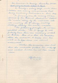
Handwritten copy of items for the Newsletter. Included is Machinery Contractor Called to Task. He took a lot longer to do the work than he should have. Boys Will Be Boys tells of a boy who was supposed to driving the whim horse, but in the absence of the braceman, he amused himself by taking a truck out of the cage and putting it back again. Then he started stepping backwards and forwards by holding onto a rope across the shaft, then fell down the shaft. He got a severe shaking. Cheers and Groans are about the long hours the miners worked and the introduction of the 8 hour day. Primitive Shafts is about the Victoria Reef Shafts. It tells of the underground working and raising the ore, crushing and yield.document, for historical society bendigo branch newsletter, federal australian, st mungo crushing battery, a richardson, royal hotel, bendigo advertiser, angus mackay, regulation of mines 1874, victoria reef quartz co, victoria quartz, grant and co, dicker's mining record 23/11/1861 pages 9 and 10 -
 Ballarat Tramway Museum
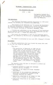
Document - Report, Ministry of Transport, "Ministry of Transport Authority Annual Reports 1982/83", 1983
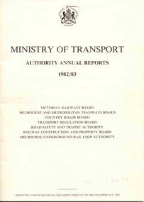
84 page, printed report on white art paper - titled "Ministry of Transport Authority Annual Reports 1982/83" for the: Victorian Railways Board Melbourne and Metropolitan Tramways Board Country Roads Board Transport Regulation Board Road Safety and Traffic Authority Railway Construction and Property Board Melbourne Underground Rail Loop Authority This document represented the final report of the listed authorities who were abolished on 30/6/1983 and replaced by the Metropolitan Transit Authority, State Transport Authority, the Road Traffic Authority and the Road Construction Authority. Signed by the Minister S.M. Crabb. Has on the inside cover, a stapled With Compliments slip with the name of Race Mathews MP typed in.On front cover in pencil, "142 4 Sept 84'trams, tramways, mmtb, vr, annual reports -
 Melbourne Tram Museum
Document - Report, R. J. H. Risson, Melbourne and Metropolitan Tramways Board, "Public Transport in Big cities", 1966
Report 6 pages, photocopied onto head sensitive paper titled "Public Transport in Big cities" printed in the October - December 1966 issue of Australian Transport. Written by R. J. H. Risson, Chairman of the MMTB. Includes a photo of the author. Paper looks at Public Transport in Melbourne, its past and where it is going, car parking, that trams will stay in Melbourne, US cities though winding down, UK hardly a model, must do better, looks at New York, growing cities, the work place and workforce, transport essentials, fares, speed, new buses and trams, articulated vehicles, solutions, plans for Melbourne, underground tramways. Has photos of European trams.On rear of page 5 are a numb er of algebraic equations!trams, tramways, mmtb, tramway, melbourne, underground tramways, new trams, public transport -
 Melbourne Tram Museum
Document - Report, Australian Railway Union and others, "Melbourne Transportation Study - The Transportation Plan - 1970 to 1985", 1970
A series of four reports regarding the implementation and work done by the Metropolitan Transportation Committee completed in 1969. Prepared by Australian Railways Union, Boilermakers and Blacksmiths Society, Tramway Employees' Association and the Amalgamated Engineering Union. .1 - Bulletin No. 1 - 18 white sheets duplicated - looks at the plan, results, services, motor vehicles and public transport. .2 - Bulletin No. 2 - 14 - yellow sheets duplicated - The Press and the Plan. .3 - Bulletin No. 3 - 10 pink sheets duplicated - The Underground loop - to be or not to be. .4 - Report on the Teach-in held on 15/5/1970 - 3 green sheets stapled - refers to the above documents and the 4th - The MMTB - its past and present - what of its future (that was in course of preparation)trams, tramways, public transport, history, mmtb, transportation plan, unions, melbourne, railways -
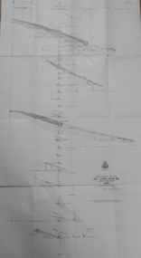
 Bendigo Historical Society Inc.
Map - GREAT EXTENDED HUSTLER'S MINE - TRANSVERSE SECTION OF THE GREAT EXTENDED HUSTLER'S MINE
Transverse Section of the Great Extended Hustler's Mine on the Hustler's Line of Reef. Bulletin No 33, Plate No XII. Shows Poppet legs at the surface and Sill of Shaft at 788.99 feet above Sea Level, Cross Cuts and their depths, stone and geographical features encountered and their references and a number of enlarged drawing of sections of the crosscuts, Geological Survey of Victoria emblem and signed by H A Whitelaw, Underground Survey Office Bendigo, September 1913. The depths of crosscuts to No 21 were taken from plans of surveys by Mr. Walker and Mr. Craven, noted under Reference. Another note: This Saddle Reef is sketched from Mr. Walker's plan. Dividends amounting to 360,000 pounds were obtained from it. mining, parish map, great extended hustler's mine, transverse section of the great extended hustler's mine, old shaft, mr walker, mr craven, geological survey of victoria, underground survey office bendigo, h a whitelaw -
 Bendigo Historical Society Inc.
Map - HUSTLER'S REEF & HUSTLER'S REEF NO 1 MINES - PLAN OF THE HUSTLER'S REEF & HUSTLER'S REEF NO 1 MINES
Plan of the Hustler's Reef & Hustler's Reef No 1 Mines on the Hustler's Line of Reefs, Bendigo Bulletin No 33, Plate No XIV. No 8 connecting No 10 (Hustler's Reef), No 11 connecting No 13 (Hustler's Reef), No 13 (Hustler's Reef No 1) connecting No 15 (Hustler's Reef) and No 10 Hustler's Reef No 1 rise to Comet Mine. Map shows different levels in relation to the two shafts, the lines of the Hustler's Line of Reefs and the Lightning Hill Line of Reefs, the approximate Boundary of Lease and the Comet Co., the adjoining lease. Table on the left shows the levels and their depths of the two mines. Signed by H A Whitelaw, Underground Survey Office, Bendigo, September 1913. Geological Survey of Victoria emblem. mining, parish map, hustler's reef & hustler's reef no 1 mines, hustler's line of reefs lightning hill line of reefs, comet co., h a whitelaw, underground survey office bendigo, geological survey of victoria -
 Bendigo Historical Society Inc.
Photograph - AUSTIN COLLECTION: Central Deborah Gold Mine Lift Shaft
Central Deborah Gold Mine history: At its peak, Central Deborah Gold Mine reached a depth of 412 metres. It has 17 separate levels and 15 kilometres of drives and cross cuts (tunnels). The Central Deborah was very much a hands-on mine and the conditions that the miners worked in would be considered shocking by today's standards – being lowered underground in a cage with only two sides, often working ankle to knee deep in water, filling up to 32 ore trucks a shift by hand which were then pushed a mile or more along rails in the drives, working by carbide lamp, breathing in the fumes and rock dust and communication by bells. Geez, they were ironmen. However, at the time working conditions were considered to be among the best on the goldfields at Central Deborah, after all it was one of the only mines that had hot showers. Following Central Deborah Gold Mine's closure, the Bendigo skyline began to noticeably change. Obvious remnants of mining such as poppet heads, engine rooms, service quarters, battery houses and chimneys were steadily disappearing. After intense lobbying by the local community, the Bendigo City Council purchased the still very much intact Central Deborah Gold Mine in 1970 for a mere $6,000 to ensure that a vital link to Bendigo's historic golden past was maintained. The Bendigo Trust was then formed to oversee the operations of the Central Deborah Gold Mine, which led to the surface of the mine being opened to the public in 1971. Initially the surface was open for just 12 hours a week and as the demand for viewing a part of Bendigo's history increased, so did the opening hours. In 1974 the mine was gazetted as a Public Historical Purposes Reserve and attracted such visitors as H.R.H Prince Charles. By far the greatest shortcoming at this stage was that no one could view the underground workings, as these had become flooded. After what could only be described as a monumental effort by everyone involved, Level 2 of the mine was officially opened to the public by the Premier of Victoria, the Honourable John Cain, on 20 June 1986, which brought to fruition a long standing dream.Black and white photograph, looking from bottom of lift shaft towards the surface; light visible at top of shaft. Lift cables and safety mesh on sides of shaft. gold mining, central deborah gold mine, ray beer, mine manager -
Bendigo Historical Society Inc.
Photograph - AUSTIN COLLECTION: Central Deborah Gold Mine, Possibly 1990's
Central Deborah Gold Mine history: At its peak, Central Deborah Gold Mine reached a depth of 412 metres. It has 17 separate levels and 15 kilometres of drives and cross cuts (tunnels). The Central Deborah was very much a hands-on mine and the conditions that the miners worked in would be considered shocking by today's standards – being lowered underground in a cage with only two sides, often working ankle to knee deep in water, filling up to 32 ore trucks a shift by hand which were then pushed a mile or more along rails in the drives, working by carbide lamp, breathing in the fumes and rock dust and communication by bells. Geez, they were ironmen. However, at the time working conditions were considered to be among the best on the goldfields at Central Deborah, after all it was one of the only mines that had hot showers. Following Central Deborah Gold Mine's closure, the Bendigo skyline began to noticeably change. Obvious remnants of mining such as poppet heads, engine rooms, service quarters, battery houses and chimneys were steadily disappearing. After intense lobbying by the local community, the Bendigo City Council purchased the still very much intact Central Deborah Gold Mine in 1970 for a mere $6,000 to ensure that a vital link to Bendigo's historic golden past was maintained. The Bendigo Trust was then formed to oversee the operations of the Central Deborah Gold Mine, which led to the surface of the mine being opened to the public in 1971. Initially the surface was open for just 12 hours a week and as the demand for viewing a part of Bendigo's history increased, so did the opening hours. In 1974 the mine was gazetted as a Public Historical Purposes Reserve and attracted such visitors as H.R.H Prince Charles. By far the greatest shortcoming at this stage was that no one could view the underground workings, as these had become flooded. After what could only be described as a monumental effort by everyone involved, Level 2 of the mine was officially opened to the public by the Premier of Victoria, the Honourable John Cain, on 20 June 1986, which brought to fruition a long standing dream.Black and white photograph. Two men with hard hats and lights, inspecting quartz outcrop on wall of drive at Central Deborah Gold Mine.gold mining, central deborah gold mine, ray beer, mine manager -
 Bendigo Historical Society Inc.
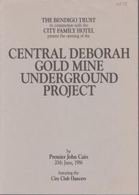
Booklet - Central Deborah Gold Mine Underground Project, 20th June, 1986
Two page booklet. On front cover: The Bendigo Trust in conjunction with the City Family Hotel. present the opening of the Central Deborah Gold Mine Underground Project by Premier John Cain 20th June, 1986, featuring City Club Dancers. Contents include: 'The Legend of Golden Lady Deborah'; the 'Awakening of Deborah' and a description of the Central Deborah Goldmine. Listed are acknowledgements of assistance given by the City Family and City Club; Gillies; Sandhurst Dairies; McDonalds; Swan Breweries; 3BO;, Domenic House of Hair and Beauty; ESG Studios, Selex-Decal; Victoria Police Band; V-Line; Bendigo Timber; Stonemans; Alan Williams Sound; Radio Rentals; Waterfall Quarries; Arthur Holt; Bart N Print and Sandhurst Town. central deborah gold mine, gold, opening of mine, john cain -
 Melbourne Tram Museum
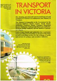
Poster, Minister of Transport, Transport in Victoria", late 1970's
Full colour poster, single sided, printed on gloss white paper, titled Transport in Victoria", giving details of the functions and the various authorities and boards reporting to the Ministry of Transport. , Country Roads Board, Victorian Railways Board, Westgate Bridge Authority, Melbourne Tramways Board, Melbourne Underground Rail Loop Authority, Transport Regulation Board, Railway Construction Board Has photos of the various activities of the Boards, including an aerial photo of Melbourne CBD from the south east, showing the Flinders St rail yards. Photo of Z class tram, but number has been removed. Has the Ministry logo in the bottom right hand corner. See also Reg Item 1352 for a book of the same title.In ink in top left hand corner "4J40" - AETA Library location.trams, tramways, minister for transport, railways, trb, crb, murla -
 Bendigo Historical Society Inc.
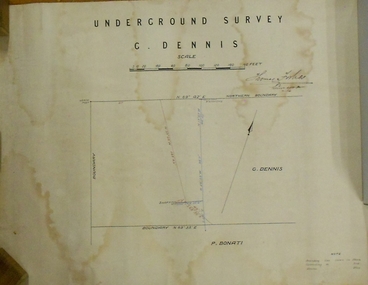
Plan - MARKS COLLECTION: PLAN OF UNDERGROUND SURVEY G. DENNIS MINE
Plan drawn on heavy parchment 'underground survey G. Dennis' printed on top of plan. Plan shows boundary lines and peg site. P. Bonati claim marked on bottom of plan. B. Letter with plan on letterhead 'City of Sandhurst, Town Hall, July 2nd. 1873' Addressed to Mr. George Dennis, Sir, In reply to your letter of the 19th. ulto I am empowered to state that subject to the formation of the road referred to, your existing rights are conserved, and the council will undertake not to object to the renewal of your lease. The only conditions being that you shall not sink a shaft in the street or attempt to obstruct it when formed. I have the honor to be, Sir, your obedient servant, Geo Fletcher, Town Clerk.bendigo, mining, g. dennis claim -
 Bendigo Historical Society Inc.
Map - GREAT EXTENDED HUSTLER'S MINE - LONGITUDINAL SECTION OF THE GREAT EXTENDED HUSTLER'S MINE
Longitudinal Section of the Great Extended Hustler's Mine on the Hustler's Line of Reefs. Bulletin No 33, Plate No XIII. Map shows the Hustler's Tribute, 2 Old Shafts, Great Extended Hustler's Shaft, Latham & Watson's Shaft and Ironbark Gully. Datum Line 750 feet above Sea Level. Poppet Legs on the surface and Sill of Shaft 788.99 feet above Sea Level. Levels and their depths are shown and some geographical features. Some amounts of gold mined mentioned. Geological Survey of Victoria emblem and signed by H A Whitelaw, Underground Survey Office Bendigo, September 1913. Note - Plates 4, 8, 13,20, 26 & 31 form a Longitudinal Section from Fortuna Hustlers to Hustler's Consols Mine. mining, parish map, great extended hustler's mine, geological survey of victoria, underground survey office bendigo, h a whitelaw, hustler's tribute, old shaft, great extended hustler's shaft, latham & watson's shaft, ironbark gully -
 Bendigo Historical Society Inc.
Map - UNITED HUSTLER'S & REDAN & K. K. MINES - PLAN OF THE UNITED HUSTLER'S & REDAN & K. K. MINES
Plan of the United Hustler's & Redan & K. K. Mines Bulletin No 33 Plate No XXXI. Shows depth of levels, Probable positions of reefs and natural surface with the poppet legs at the two shafts. Sill of shaft of the K. K. Mine 773.56 ft above Sea Level and sill of shaft of the United Hustler's & Redan Mine 745.62 above Sea Level. Also mentioned is the average amount of gold obtained per ton. Note on the top of page - Plates 4, 8, 13, 20, 26 & 31 form a Longitudinal Section from Fortuna Hustler's to Hustler's Consols Mine. Geological Survey of Victoria emblem and signed by H S Whitelaw, Underground Survey Office, Bendigo, September 1913. mining, parish map, united hustler's & redan & k. k. mines, geological survey of victoria, h s whitelaw, underground survey office bendigo -
Federation University Historical Collection
Booklet, Education Department Victoria, Victorian Education Department Course of Study of primary Schools: Social Studies, 1954 and 1956
.1) 18 page booklet relating to the Victorian Education Department Course of Study of Primary Schools: Social Studies grades 1 to 6. Topics include family and home, how the community lives and works, Beyond the Neighbourhood (Africa, Canada, New Guinea, India, China, Italy, English factory town), The World About Me (School, home, food, clothes), Our Own Land (The Australia Our Ancestors Found - unknown interior, sheep, riches from underground, water, grain, cows, meat, tropics, tall timbers, manufacture, Melbourne, travel), The Land of Our Fathers (British Descent, From other Countries .2) Victorian Education Department Course of Study of primary Schools: Social Studies, Grades VII and VIII 6 page printed bookleteducation department, social studies, education -
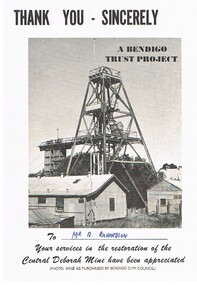 Bendigo Historical Society Inc.
Document - CENTRAL DEBORAH MINE
5 pieces of information/advertising material for the Central Deborah Mine. A. Thankyou card presented to A. Richardson in appreciation of assistance with restoration of the mine. B&C. Diagram of the layout of the mine area, including highlights of underground tours, Key dates of the mine history and a map key to layout on the front of the pamphlet. D&E. Complimentary copy of a guide to the Central Deborah Gold Mine, showing the layout of the area and a description of each numbered site at the site. F&G. Advertising brochure, similar to the previous copy, D&E, with numbered locations at the site, and descriptions of each site. Includes additonal information re, Room 2 (change room) and Model room. H&I. Pamphlet of the mine area, showing chronological history, and short description of theach numbered site.gold mining, miners' safety cage, central deborah mine. -
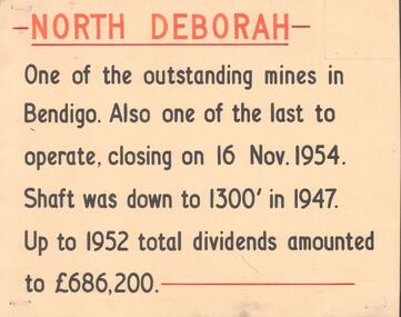 Bendigo Historical Society Inc.
Document - NORTH DEBORAH , DEBORAH, CENTRAL NELL GWYNNE AND NAPOLEON GOLD MINES
Five interpretive cards used for displays, yellow with black and orange text, describing the North Deborah, Deborah, Central Nell Gwynne and Napoleon Gold Mines. a. North Deborah: closed 16th November 1954. Shaft was 1300 feet deep. Total dividends 686,200 pounds. b. Deborah: underground operations suspended 1952, shaft 2076 feet. c. Central Nell Gwynne: operations ceased at end of 1949, shaft depth 1933 feet. d. Napoleon: first subsidiary company formed by BML to carry out comprehensive programme of development along Napoleon anticline. Shaft 1054 feet in 1937 when opertions ceased. e. Devonshire Sands, formed in 1933. Cyanide leaching plants installed on sand tailings heaps at Bendigo.Albert Richardsonbendigo, mining, north deborag mining company -
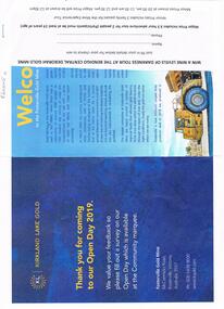 Bendigo Historical Society Inc.
Document - FOSTERVILLE GOLD MINE COLLECTION: OPEN DAY 2019
Two page document for Kirkland Lake Gold Open day 2019. Open Day activities include: bus tours, technical services display, geology, exploration, processing, community and environment display, minerals council of Australia, Swick drilling, Central Deborah Gold Mine, Face painting, Goldfields Re-vegetation, Delecca's hire equipment, MacMahon underground mining services, Sandvik, and ISH24 safety specialists. Map of 'Fosterville Gold Mine Site Map' with activities highlighted. Fosterville is Victoria's larges gold producer and in 2918 a records 356,230 ounces at an average grade of 24.9 g per tonne. The mine has over 600 full time employees in 2019. Entry for '9 levels of darkness' tour at Central Deborah Mine attached.bendigo, mining, fosterville gold mine -
 Bendigo Historical Society Inc.
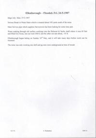
Document - DRAINAGE PROBLEMS - ELLENBOROUGH FLOODED
Handwritten copy of a report in the Bendigo Advertiser 24/5/1907. ''Serious break in Water Main which is situated about 100 yards south of the mine. Main service pipe which supplies Harveytown has been leaking for some time past. Water soaking through old surface workings into the Belmont & Saxby shaft where it rose 60 feet and filled two x-cuts, one out weat 208 ft, and the other out east about 45 ft. Ellenborough began baling on Sunday 26th May, and it will take many days before work can be resumed. The mine was only working one shift and no men were underground at time of in rush''. Document from Albert Richardson Collection of mining history.document, gold, drainage problems, drainage problems, ellenborough flooded, bendigo advertiser, 27/5/1907, harveytown, belmont & saxby, ellenborough, albert richardson -
 Melbourne Tram Museum
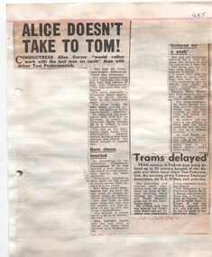
Newspaper, The Sun, The Herald, The Age, Southern Cross, "Alice doesn't take to Tom!" "Tram Depot is down 8" "psst - that may be the checker watching", Dec. 1968
Newspaper Clipping - set of some 25 clippings adhered to both sides of 12 sheets generally of ruled quarto paper with punched holes on the left hand side the black banning of driver Tom Pesteranovich and associate industrial issues. Principal headings are: "Alice doesn't take to Tom!" "Tram Depot is down 8" "psst - that may be the checker watching" "Fifth trammie on the Mat" "Now Harry is barred over Tom" "4 Trammies to face a judge" "He's on the blacklist" "Tram men could go out today" Includes a cartoon by Jeff about Henry Bolte and the Underground railway. Cuttings from The Herald, The Age and Sun, Southern Cross newspapers. Includes a photo of Tom Pesteranovich. See also Reg Items 2561 and 2562 for further items on this industrial matter.trams, tramways, mmtb, glenhuntly tram depot, unions, drivers, fares, ticket inspectors, railways -
 Bendigo Historical Society Inc.
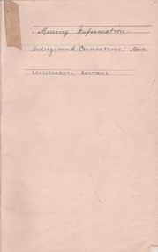
Document - ALBERT RICHARDSON COLLECTION: UNDERGROUND CONNECTIONS
Buff cover, exercise book. On front cover: Mining Information. Underground Connections Approx. Longitudinal Sections. First page contains an index of the mines. Book contains handwritten records of the connections between the mines under Bendigo. Mines in index: Carshalton Line, Lancashire Line, Napoleon Line, British and Foreign Line, Nell Gwynne Line, New Chum Line, Eureka Extended, New Chum Railway, Shenandoah, Young Chum, Garibaldi, Ellesmere, New Chum United, Lansells 222, Lazarus, North Old Chum, Lansells Big 180, Great Extended Victoria, New Victoria, Catherine, New St. Mungo, Duchess of Edinburgh, Phoenix, St. Mungo, Sadowa, Acadia, Williams United, Catherine Reef United. Garden Gully Line, Great Southern to Ulster United.bendigo, mining, underground connections -
 Bendigo Historical Society Inc.
Map - HUSTLER'S ROYAL RESERVE NO 2 MINE - PLAN OF THE HUSTLER'S ROYAL RESERVE NO 2 MINE
Plan of the Hustler's Royal Reserve No 2 Mine Bulletin No 33, Plate No V. Plan shows the Hustler's Royal Reserve No 2 (Main Shaft), Hustler's Royal Reserve No 2 (Park Shaft.), the Royal Hustler's, the Imperial Hustler's and the Extended Hustler's Freehold on the Hustler's Line of Reefs. Also mentioned is the Lightning Hill Line of Reefs. Map shows some of the levels, approximate boundary of lease and the boundary of Lease No 8892 and 8897. There are also street names and the locations of jail, lagoons, Post Office, Rosalind Park and the State School, High School and Continuation School. Geological Survey of Victoria emblem. H. Herman Director, W. Dickson, Secretary of Mines and The Hon. J. Drysdale Brown MLC, Minister of Mines. Signed by zh Whitdan, Underground Survey Office, Bendigo, September 1913.mining, parish map, hustler's royal reserve no 2 mine, royal hustler's, imperial hustler's, extended hustler's freehold, geological survey of victoria, h herman, w dickson, the hon j drysdale brown, h whitdan, hustler's line of reefs, lightning hill line of reefs -
 City of Moorabbin Historical Society (Operating the Box Cottage Museum)
Photograph, Black & White Postcard, Cheltenham Railway Station c1920, c1920
Although the Railway line had been planned for some time Sir Thomas Bent MP was responsible for making it happen in order to revitalize the fortunes of the Moorabbin Shire that he had represented for so long. The train line opened in 1881with 8 Stations between Caulfield and Mordialloc.The first Steam engine carried dignitaries and local residents. Bent also ensured that the Station houses in his constituency were built in a distinctive decorative cottage style. Bent faced severe criticism for diverting the rail line through his local area and for the expenditure on the Stations. Local residents established and cared for Gardens at the Stations and Cheltenham was awarded Best Garden c1910. The arrival of the Railway Line saw the traders move from Point Nepean Rd to Charman Rd and by 1910 various shops and business were present. 2016 - current has seen large protest rallies against the destruction of Mentone Station and Cheltenham Station as the Victorian State Government proceeds to remove Railway Level Crossings. A compromise to retain the Station buildings whilst placing the Rail Line underground is desired.Cheltenham Railway Station is one of the original cottage style stations ordered by Sir Thomas Bent when the rail line was extended from Caulfield to Mordialloc 1881Photograph Black & White Postcard showing the entrance to Cheltenham Railway Station c1920Valentine &Sons Pub Co Ltd Melb railways, cheltenham station, mentone station, south brighton station, railway level crossing removal 2016 -19, smith j l; smith mary ann, stanley helen, smith vic, smith harry redvers, chaff cutter, horse drawn carts, toll gates brighton, motor cars 1900, steam engines, early settlers, bentleigh, parish of moorabbin, city of moorabbin, county of bourke, moorabbin roads board, shire of moorabbin, henry dendy's special survey 1841, were j.b.; bent thomas, o'shannassy john, king richard, charman s, highett william, ormond francis, maynard dennis, market gardeners, vineyards, orchards -
 Kiewa Valley Historical Society
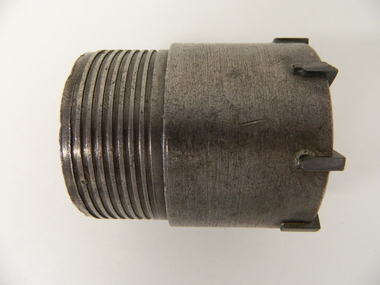
Drill Bit Diamond, circa mid to late 1900's
This hollow core bit has hard cutting inserts for drilling into rock. It was used to drill and recover 50mm diameter (most common size) rock cores. The rock cores were assessed by geologists and engineers to provide information for design of structures such as tunnels, dams and underground power stations (eg. McKay Creek Power Station, West Kiewa Power Station). This type of bit was also used where damage to the surrounding rock had to be minimised. The Diamond Drill Bit,used in the early 1900's, when it was primarily used as a method of sampling rock for ore deposits and oil exploration resulting in a "coring" of rock. The use of "coring" to obtained samples for the SEC Kiewa Hydro Electricity Scheme(1920's onward) was to analyse the core to obtain temperature and rainfall patterns shown by the levels of layered solidified soil(rock). This diamond drill would have been used in the early 1900's to provide a sub strata map of temperature and water patterns (over an long period of time). This was a pre requisite to any decisions about the viability of the region to provide the water needed for a successful hydro electricity scheme.This diamond drill for core sampling was at the forefront of the analysis whether to construct a hydro electrical facility in the Kiewa Valley and the adjoining alpine region. The rock core samples produced were assessed by geologists and structural engineers. It was only after extensive core drilling covering the region that solid scientific evidence could be provided to start the "SEC Vic Hydro Electricity Scheme" within its current boundaries.This "diamond" drill bit has eight "teeth" at its cutting edge. The drill creates an 55mm hole in extremely hard rock material to obtain 50mm core samples.. Three quarters down the shank it has thread screw channels to attach the bit to the drill pipe. The coring pipe attaches via screwing it onto this bit. Core samples are the main objective of this tool.alternate energy supplies, alpine feasibility studies temperature, rainfall, sec, kiewa hydro electric scheme, electricity -
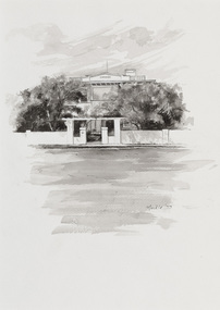 Bayside Gallery - Bayside City Council Art & Heritage Collection
Work on paper - ink and watercolour, Annette Meikle, Karinga, 1977
In 1977, artist Annette Meikle undertook a commission to illustrate a book recording stories of places and people in the Bayside area. It was published in 1978 as Sandringham Sketchbook, with text by Elizabeth Waters. The sketches were intended to record remaining examples of Bayside’s early architecture and environment, as well as reflect newer architectural changes. Meikle went on to donate 22 of these sketches to Bayside City Council in 2003. This inter-war house located at 60 Bluff Road, Black Rock, was built in 1926 for former Scotland Yard and Criminal Investigation Branch detective Horatio Reginald Clarence McWilliams. When McWilliams died it was found that he had taken extreme measures to protect his security. All the windows were nailed shut, a network of burglar alarms ran through the house and a complicated underground air raid shelter had been built in the garden. The security measures were at odds with the name of the house – Karinga or Karinya – an Aboriginal word meaning peaceful, happy home. Later residents of ‘Karinga’ included Senator Don Chipp and his family. The property has since been demolished and apartments have been built on the land.Annette Meikle, Karinga 1977, ink and watercolour, 32 x 23.5 cm. Bayside City Council Art and Heritage Collection. Donated by the artist, 2003annette meikle, sandringham sketchbook, elizabeth waters, black rock, karinga, karinya, horatio reginald clarence mcwilliams, senator don chipp, historic house, bluff road