Showing 762 items
matching aerial views
-
 Federation University Historical Collection
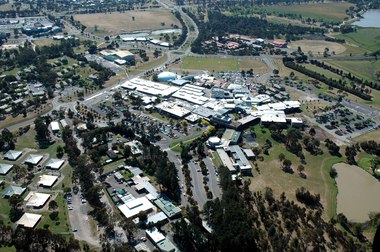
Photograph, Aerial View of Gippsland Campus, 2004
... Aerial View of Gippsland Campus... Photograph Aerial View of Gippsland Campus Photograph ...In 1989 Monash University took over the Gippsland Institute of Advanced Education to create Monash Gippsland Campus. In 2014 the University of Ballarat and the Churchill Campus of Monash University merged to become Federation University Australia.Photograph of the Federation University Gippsland Campus during its era as a campus of Monash University. gippsland campus collection, monash university gippsland campus, churchill, aerial -
 Federation University Historical Collection
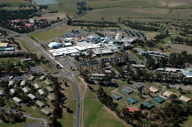
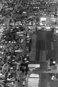
Photograph, Aerial View of Gippsland Campus looking over Northways, 2004
... Aerial View of Gippsland Campus looking over Northways... Photograph Aerial View of Gippsland Campus looking over Northways ...In 1989 Monash University took over the Gippsland Institute of Advanced Education to create Monash Gippsland Campus. In 2014 the University of Ballarat and the Churchill Campus of Monash University merged to become Federation University Australia.Photograph of the Federation University Gippsland Campus during its era as a campus of Monash University. gippsland campus collection, monash university gippsland campus, churchill, aerial, student residences -
 Federation University Historical Collection
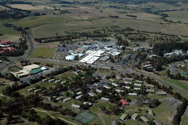
Photograph, Aerial View of Gippsland Campus looking over the Student Residences, 2004
... Aerial View of Gippsland Campus looking over the Student... Photograph Aerial View of Gippsland Campus looking over the Student ...In 1989 Monash University took over the Gippsland Institute of Advanced Education to create Monash Gippsland Campus. In 2014 the University of Ballarat and the Churchill Campus of Monash University merged to become Federation University Australia.Photograph of the Federation University Gippsland Campus during its era as a campus of Monash University. gippsland campus collection, monash university gippsland campus, churchill, aerial, student residences -
 Federation University Historical Collection
Photograph - Colour, Aerial Photograph of Federation University Mount Helen Campus, c2010
Federation University Australia was established on 1 January 2014. Formerly known as the University of Ballarat, its enabling legislation was the University of Ballarat Amendment (Federation University Australia) Act 2013. Although formally created as a University in 1994, the University of Ballarat has a lineage back to 1870 with the establishment of the School of Mines Ballarat, making it the third institution of higher learning to be established in Australia and the first to be established in regional Australia. On 1 January 1994, Ballarat University College became the University of Ballarat and in 1998 the University merged with three TAFE Institutes to become a dual sector institution with multiple campuses. On 1 January 2014, the University of Ballarat amalgamated with the Monash University Gippsland Campus to form Federation University Australia. The Gippsland Campus also had a long lineage dating back to 1928 with the establishment of the Yallourn Technical School which became a predecessor institution to the Gippsland College of Advanced Education formed in 1968. In 1990, it was renamed the Monash University College and in 1993 became the Gippsland Campus of Monash University. In 2016, Federation University Australia announced plans to take possession, over a two-year period, of Monash’s Berwick Campus in the south-east corridor of Melbourne. Federation University Australia, or FedUni, is headquartered in Ballarat and offers programs in Higher Education and Vocational Education and Training to regional Victoria and beyond. The University’s commitment to educational and social equity, teaching excellence, research distinction, environmental sustainability and regional capacity building has enabled it to develop in a way that draws on its proud heritage to inform its future. Its regional character sets a framework for the University’s priorities but does not constrain it from serving wider community interests, nationally and internationally. The name Federation University Australia was chosen to convey the scope and capacity of an expanded regional university with a federated network of campuses.Colour photograph showing an aereal view of the Federation University Mount Helen Campus.aerial, mount helen campus, federation university -
 Federation University Historical Collection
Photograph - Colour, Aerial Photograph of an area of Ballarat
Colour photograph showing an aereal view of an area of Ballarataerial, ballarat -
 Federation University Historical Collection
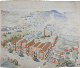
Painting - Artwork Plan, Birdseye View of the Ballarat School of Mines, 1915
Herbert Leslie (Les) COBURN (1891-1956) Australia This work was commissioned by the SMB Council to hang in its chambers. It envisions the new Junior Technical School building and was illustrated in the same year the Ballarat Technical Art School building officially opened. Les Coburn was a student at the Art School between 1908 and 1916. Coburn and his business partner, Percival Selwyn Richards (1865-1952), became joint instructors in architecture and building construction at the school from 1920, with Coburn continuing until 1948. Watercolour plan drawing on paper of Ballarat School of Mines showing the Museum, Administration building, Technical Art School, and proposed Junior Technical School, Ballarat School of Mines Botanical Gardens, and the Ballarat Gaol Governor's Residence. ballarat school of mines museum, ballarat technical art school, ballarat junior technical school, watercolour, cr. h. l. coburn, aerial, ballarat school of mines, birdseye view, h.l. coburn, herbert leslie coburn, les coburn -
 Federation University Historical Collection
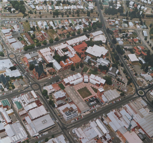
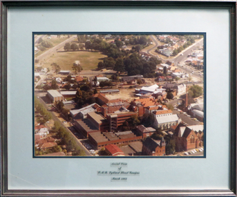
Photograph, Aerial view of the Ballarat School of Mines Lydiard Street Campus
... Aerial view of the Ballarat School of Mines Lydiard Street... Photograph Photograph Aerial view of the Ballarat School of Mines ...Large format colour photograph of the Ballarat School of Mines Campus.smb campus, aerial photograph, aerial photograph smb, ballarat school of mines, ballarat school of mines, lydiard street south, ballarat -
 Federation University Historical Collection
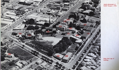
Image, Ballarat School of Mines Aerial View with Dates of Buildings, 1976
... Ballarat School of Mines Aerial View with Dates of... Ballarat School of Mines Aerial View with Dates of Buildings Aerial ...Aerial photograph of the Ballarat School of Mines, with establishment date for each building. ballarat school of mines, aerial, buildings, former ballarat gaol, mining laboratory, hillman hall, former supreme court, administration building, ballarat technical art school, former wesley church, ballarat girls technical school, ballarat junior technical school, albert street, grant street, lydiard street south, armstrong street south, dana street -
 Federation University Historical Collection
Photograph - coloured, Aerial view of SMB Lydiard Street Campus, March 1982
... Aerial view of SMB Lydiard Street Campus, March 1982... Photograph - coloured Aerial view of SMB Lydiard Street Campus, March ...SMB was established on the area on the area of the Ballarat Gaol. The Gaol has been demolished but the Brewery still stands. Hillman Recreation Centre is under construction. The tennis courts are still evident, now the site of the M B John Building.Timber frame with silver/red paint, pale blue and dark blue mount board with glass.ballarat school of mines, ballarat gaol, hillman recreation building, tennis courts, m b john, brewery -
 Federation University Historical Collection
Photograph, Aerial View of the Mount Helen Campus
... Aerial View of the Mount Helen Campus... Photograph Aerial View of the Mount Helen Campus ... -
Federation University Historical Collection
Photograph, Aerial View of the Ballarat College of Advanced Education, 1986
... Aerial View of the Ballarat College of Advanced Education... Photograph Aerial View of the Ballarat College of Advanced Education ...Black and white photograph of the Mount Helen Campusmount helen campus, ballarat college of advanced education, aerial photograph, student residences -
Federation University Historical Collection
Photograph, Aerial View of Mount Helen Campus
... Aerial View of Mount Helen Campus... Photograph Aerial View of Mount Helen Campus Two aerial viewls ...Two aerial viewls of Mount Helen Campusaerial, mount helen campus, buildings -
 Phillip Island and District Historical Society Inc.
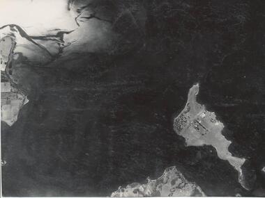
Photograph
... Churchill Island Aerial view... photograph coastline islands Churchill Island Aerial view John Jenner ...One of a collection of over 400 photographs in an album commenced in 1960 and presented to the Phillip Island & Westernport Historical Society by the Shire of Phillip IslandAerial photograph of Churchill Island taken in 1939.local history, photography, churchill island, black & white photograph, coastline, islands, churchill island aerial view, john jenner, bryant west -
 Phillip Island and District Historical Society Inc.
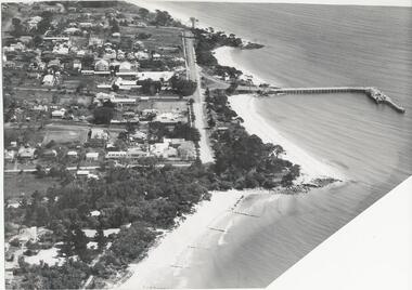
Photograph, Bryant West
... aerial view of cowes phillip island... foreshore foreshore jetty cowes aerial view of cowes phillip island ...One of a collection of over 400 Photographs in an Album commenced in 1960 and presented to the Phillip Island & Westernport Historical Society by the Shire of Phillip IslandAerial photograph of Cowes, Foreshore and Jetty looking west.local history, photography, photographs, cowes jetty foreshore, foreshore jetty cowes, aerial view of cowes phillip island, john jenner, bryant west -
 Phillip Island and District Historical Society Inc.
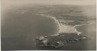
Photograph, Bryant West
... aerial view of cape woolamai... woolamai aerial view of cape woolamai john jenner bryant west ...One of a collection of over 400 photographs in an album commenced in 1960 and presented to the Phillip Island & Westernport Historical Society by the Shire of Phillip Island.Aerial Photograph of Cape Woolamai looking north-west.local history, photography, photographs, coastline, cape woolamai, aerial view of cape woolamai, john jenner, bryant west -
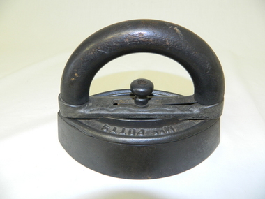 Kiewa Valley Historical Society
Iron - Flat, Circa early 1900s
... "Iron". Both are clearly visible when viewed from an aerial... are clearly visible when viewed from an aerial position. Under ...Historically this item was used before the spirit and the electrical iron took over Circa 1930s -1950s. The main body of the iron was placed on a flat heated surface of a stove (wood, coal or gas fired). It was mainly used by women in their domestic role, ironing the family clothes and linen. In the Kiewa Valley the supply of coal or gas was not available or too expensive than the locally cut hard wood trees. This particular iron was an improvement on the fixed handled iron because it allowed (by use of its easily detachable handle) to use multiple bases and thereby allowing a constant heat supply to be maintained and not having to waste time for a base to reheat to the required level of application.The significance of this item was that it allowed for a faster method of ironing clothes and linen. It's invention was a progress towards reducing the time it took to undertake a very labour and intensive domestic function. The reduction of time taken for this household duty provided women great flexibility to undertake other activities. These type of improvements to basic domestic tasks liberated housewives not only physically but also mentally from the isolation of the home environment.This flat iron has a removable, clip-on handle. The handle and its release knob are of wood. The base of the handle together with the heavy flat body are made of cast iron. The body of the iron is oval shaped tapered at each end and is 40mm thick.Underneath the handle frame and on the main body, on one side, in raised lettering is "Mrs Potts" and on the other side "Iron". Both are clearly visible when viewed from an aerial position. Under removable handle and on a plate (screwed onto the main body) is "No 2"iron, antique, household, pressing clothes, domestic, laundry -
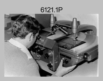 Bendigo Military Museum
photograph - Aerotriangulation Production – Army Survey Regiment, Fortuna, Bendigo, c1980
This collection of five photos was most likely taken in 1980. Wild PUG4 point transfer devices were used by technicians in Air Survey Squadron to stereoscopically view the photography containing the survey control points and the mapping aerial photography. The Control points were transferred from the control photography to the mapping diapositives of aerial photography by drilling their locations into the photographic emulsion. The Zeiss (Jena) Stecometer analytic stereocomparator for air photography was introduced at Air Survey Squadron in 1963. Aerotriangulation production was expedited using computers for analytical photogrammetric processes. The technician accurately measured between pass, tie, and survey control points on aerial photographs.Air Survey Squadron Aerotriangulation Section - Army Survey Regiment, Bendigo. c1980. This is a set of five photographs of Air Survey Squadron personnel operating aerotriangulation equipment at the Army Survey Regiment at Fortuna, Bendigo, c1980. Photographs .1P to .4P are on 35mm negative film and were scanned at 96 dpi. Black and white photo .5P is on photographic paper and was scanned at 300 dpi. They are part of the Army Survey Regiment’s Collection. .1) - Photo, black & white, c1980, Wild PUG4 point transfer device, unidentified technician. .2) - Photo, black & white, c1980, Wild PUG4 point transfer device, unidentified technician. .3) - Photo, black & white, c1980, Wild PUG4 point transfer device, unidentified technician. .4) - Photo, black & white, c1980, Zeiss (Jena) Stecometer, unidentified technician. .5) - Photo, black & white, c1980, Zeiss (Jena) Stecometer..1P to .5P No personnel are identified.royal australian survey corps, rasvy, army survey regiment, army svy regt, fortuna, asr, air survey, aerotrig -
Frankston RSL Sub Branch
Magnifier, Map Reading
A small pocket size folding magnifier used for enlarging detail when reading maps or examining aerial photographs complete with a leather storage pouch. Manufactured of brass by Casartelli of Manchester, England. When unfolded this forms a "U" shape with the glass lens positioned conveniently for map viewing and the base can be used to measure scaled distances.This item is stamped "CASARTELLI, MANCHESTER" and has 1/4, 1/2 and 1 inch markings. -
 Orbost & District Historical Society
black and white photographs, 1980s? (winter months)
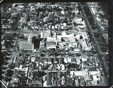
All photographs seem to have been takenfrom the Telecom tower on the corner of Browning and Wolseley Streets in Orbost 3259.1 is a view of the Orbost township looking north-east. The swimming pool and bowling club can be seen in the foreground. 3259.2 is aview looking north-west and showing the tennis courts and clubhouse, the Recreation Reserve oval, the Youth Centre, Historical Museum, Municipal Offices, Senior Citizens clubrooms with the fire station in the foreground. 3259.3 is a view looking south with the Shire of Orbost Municipal offices and Ruskin Street in the foreground. Munro Street can be seen running from Ruskin Street to St Joseph's School in the middle distance. Lochiel Park oval, Lochiel House, the Snowy River and highway bridge are in the background. 3259.4 is a view looking south showing the Club Hotel, C.B.C. Bank in the middle distance and Hoffman's paddock (Forest Park) and the Snowy River beyond. 3259.5 is a view looking north-east over houses. 3259.6 is aview over the main street, Nicholson Street.showing the main shopping precinct. Shop signs for Permewans, Williams Shoes, F.B. Dicken and Orbost Bakery can be seen. 3259.7 is a view looking south west and shows Forest park and beyond towards Bete Bolong.These photographs are detailed pictorial records of the township of Orbost.Seven black / white photographs taken from above a township. Chimney smoke can be seen in the photographs.orbost-township-1980s aerial-photograph-orbost -
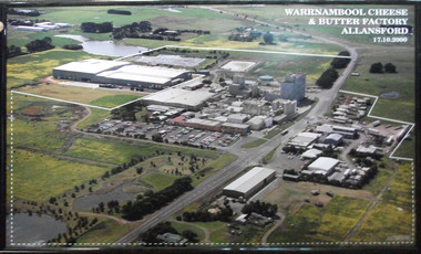 Cheese World Museum
Photograph, Warrnambool Cheese and Butter Factory Co Ltd site 2000 -aerial view, 2000
... -aerial view... Ltd site 2000 -aerial view Aerial colour photograph ...Warrnambool Cheese and Butter Factory Company was formed by a group of Warrnambool business men. The company was registered in May 1888 and commenced commercial production in November 1888. The company retained its independence for more than 125 years until acquired by Canadian firm Saputo. It has operated from the same site since its inception and also has an office in Japan. Milk processing is undertaken by Sungold. Milk powder for export is also produced on-site. Cheese World is a retail arm of the company operates on a connected site selling company products, local food products, wine and cheese tasting. Cheese World Museum operates under the Cheese World umbrella.Aerial colour photograph of Warrnambool Cheese and Butter Factory in wooden frame. Shows buildings and surrounds. Lines indicate factory boundaries, dotted lines indicate property extension. Date is recorded on the image.17.10.2000allansford, warrnambool cheese and butter factory company, saputo, dairyiing, dairy manufacturing, diary manufacturers, cheese, butter -
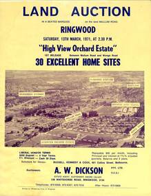 Ringwood and District Historical Society
Flyer, Land Auction Sale Brochure, High View Orchard Estate, Ringwood, Vic. - 1971
Double-sided advertisement for Ringwood High View Orchard Estate land auction sale on Saturday, 13th March, 1971, including aerial photograph, map, and summary of local facilities and services.Subdivision includes Wonga Road, Oban Road, Sang Court, Ambrie Avenue, Hendra Grove, and Mullum Mullum Road. Agent - A.W. Dickson Pty. Ltd., 136 Whitehorse Road, Ringwood, 3134. Telephones: 870 6000, 870 6007, 870 7016, after hours 870 6868. A separate copy of the advertisement includes a local newspaper follow-up clipping reports thirty home sites grossing $102,350 at the auction. -
 Ringwood and District Historical Society
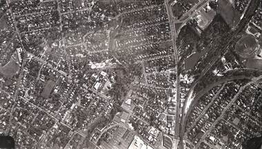
Photograph, Aerial view of Ringwood -1972
... Aerial view of Ringwood -1972... Road Ringwood North melbourne Photograph Aerial view ...Black and white aerial photographSimilar photograph -Reg 926 located in NWD 02-09-07 - Item no G0033 -
 Greensborough Historical Society
Aerial Photograph, Flintoff land - View from above, 1945_
... - View from above Photocopy of section of 1945 aerial survey ...Section of the 1945 Greensborough aerial survey, focusing on the land belonging to the Flintoff familyPhotocopy of section of 1945 aerial survey of Greensborough area"Flintoff land to west of Diamond Creek Rd" written in pencil on backflintoff family, aerial photograph -
 Greensborough Historical Society
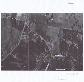
Aerial Photograph, Greenhills Aerial View, 1945_
... Greenhills Aerial View... View Photocopy of part of 1945 aerial survey. Some streets have ...Section from the 1945 aerial survey of Greensborough, including part of Diamond Creek Road, Greenhill Road, Crest Street and Albion Crescent.Photocopy of part of 1945 aerial survey. Some streets have been marked.greenhills -
 Victoria Police Museum
Photograph (police car)
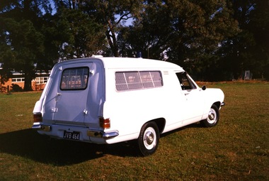
Rear view of a 1967 Holden Divisional Van, registration number JVB-464, with a blue light on the roof and visible aerial. The van windows have visible reinforcement with a turn handle on the rear door. The background of the photograph has large trees and a single level brick building. There is no visible insignia on the car. Circa 1991police vehicles; motor transport branch; motor transport section; wireless patrol; holden van -
 Sunshine and District Historical Society Incorporated
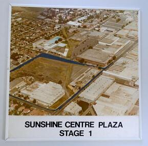
Photograph (1982) - Part Sunshine Business Area, Sunshine Centre Plaza Stage 1, 1982
... Aerial view... like 3 decades ago. Aerial view 1982 Sunshine Centre Plaza ...The Sunshine business area has undergone major change from industrial manufacturing to retail. This aerial photograph shows the industrial areas that existed on both sides of Hampshire Road in 1982, and which have since been replaced by two shopping centres and the library building. The photograph also shows the old swimming pool, and retail outlets that no longer exist such as Waltons, Clark Rubber, Fosseys and the original Safeway store. It also shows a vacant land where the current Centrelink office now exists. The photograph was originally used as a promotion for the Sunshine Centre Plaza retail complex.This photograph is a historical record of what part of Sunshine looked like 3 decades ago.Large cardboard mounted sepia photograph with thin white plastic edging. Grey painted outline shows the site in 1982 on which the SUNSHINE CENTRE PLAZA was to be built, as well the buildings that then existed in part of the business area of Sunshine.Sunshine Centre Plaza Stage 1aerial view, 1982, sunshine centre plaza, sunshine business area, massey ferguson buildings, old sunshine pool. waltons -
 Sunshine and District Historical Society Incorporated
Photographs - WHITE CITY, Pratt, Charles Daniel, (1892 - 1968)
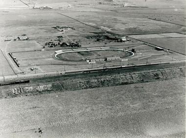
The White City Greyhound racing stadium was built at Tottenham in 1927, with the intention that mechanical lures and not live hares be used as pacemakers. The first meeting was held on 10 December 1927 but within 3 days, after strong lobbying by other sports bodies, the Victorian Government banned betting on greyhound racing if mechanical lures were used instead of live hares. This caused some financial problems to the shareholders. For a time the average weekly attendances were 9000, and races were held on Mondays, Wednesdays, and Saturdays. Whippet Races, Goat Races, Monkeys on greyhounds, and Professional Foot racing were also tried to attract attendances. After 28 years of bureaucratic interference, and using live hares as greyhound pacemakers, the White City stadium held its last meeting on 29 December 1955. On 31 December the Victorian Government finally allowed betting on greyhound races that used mechanical lures. Manufacturing industry (Olex Cables) took over the White City site. Transport to the White City stadium was provided by train, with only a single platform available on the Down side of Tottenham, even though double train lines existed. Special train services were run from Flinders Street to the White City platform, and for a while a parcels coach was provided for the transport of dogs. As industry developed in the area some trains also stopped at the White City platform in the mornings and late afternoons to transport workers. In 1981 when the grade separation at Ashley Street next to the Tottenham station was completed, the new train lines on the Upper Level came into operation, and so the White City platform was closed down and eventually demolished. The above historical information was sourced from the booklet "GOING TO THE DOGS" by Tom Rigg.Greyhound racing has always been popular in Melbourne's western suburbs. The White City stadium in Tottenham was a major centre for the sport until 1955, enabling those who could not afford race horses to take part in an animal racing sport. The demolition of first the stadium and years later the railway platform, has relegated the name White City and its past relevance to the western suburbs, into history.Two low aerial photographs of the White City Coursing stadium (Greyhound racing), plus a CD containing the same two images as well as a few other local images. The Coursing stadium was located about 500 metres from the Tottenham railway station on the down line towards Sunshine station. The photographs are thought to be from circa late 1920's to early 1930's, and one shows the view from the north facing south, while the other from the west facing east. The latter also shows built up areas of West Footscray and beyond.Only on the negatives at the State Library. We do not hold a copy of these.white city, greyhound racing stadium, coursing track, white city station, tottenham, whippet, gambling, live hare, mechanical lure -
University of Melbourne, Burnley Campus Archives
Photograph - Black and white print, Aerial View of Burnley Campus, 1977
... Aerial View of Burnley Campus...aerial view... river glenferrie road east swan street aerial view ...Framed enlargements. (A) Burnley College and surrounding suburbs showing the nearly constructed Freeway, the College in the bend of the Yarra River, Glenferrie Road to the East Swan Street to the North. (B) Enlargement of (A) showing detail of Burnley College.burnley college, suburbs, freeway, yarra river, glenferrie road, east swan street, aerial view -
 Kew Historical Society Inc
Photograph, J F C Farquhar, Bird's Eye View Looking West, 1891
At the beginning of the 1890s, the Kew businessman and Town Councillor, Henry Kellett, commissioned J.F.C. Farquhar to photograph scenes of Kew. These scenes included panoramas as well as pastoral scenes. The resulting set of twelve photographs was assembled in an album, Kew Where We Live, from which customers could select images for purchase.The preamble to the album describes that the photographs used the ‘argentic bromide’ process, now more commonly known as the gelatine silver process. This form of dry plate photography allowed for the negatives to be kept for weeks before processing, hence its value in landscape photography. The resulting images were considered to be finely grained and everlasting. Evidence of the success of Henry Kellett’s venture can be seen today, in that some of the photographs are held in national collections.It is believed that the Kew Historical Society’s copy of the Kellett album is unique and that the photographs in the book were the first copies taken from the original plates. It is the first and most important series of images produced about Kew. The individual images have proved essential in identifying buildings and places of heritage value in the district.Before true aerial photography became possible, photographers such as J.F.C. Farquhar were compelled to shoot their images from the highest vantage point. Here, it is presumed to be the roof of Xavier College, from which the panoramic view extends west towards the rise of Studley Park. The houses in the foreground face the southern end of Gellibrand Street. Wellington Street is at an angle to the camera with the Queen Street intersection on the near right. The wooden building behind the large horse paddock on the other side of Gellibrand Street is the Kew Recreation Hall, built 1888, demolished 1960. It was reputed to have one of the finest dancing floors in or around Melbourne. The Bowling Green at the rear of the Hall belonged to the Kew Bowling Club. Further west is the Kew Railway Station on Denmark Street, opened to the public in 1887. At this period, much of Studley Park was locked up in large landholdings, dominated by large mansions such as ‘Byram’. Bird's Eye View Looking Westkew illustrated, kew where we live, photographic books, henry kellett, denmark street, kew recreation hall, kew bowling club, wellington street -
 Ballarat Base Hospital Trained Nurses League
Aerial view BBH , neg Mr Harvey Photographer
... Aerial view BBH , neg Mr Harvey Photographer...Aerial, view, BBH... Street Nth Ballarat goldfields Aerial view BBH , neg Mr Harvey ...Photoaerial, view, bbh