Showing 2184 items
matching australian garden
-
 Glen Eira Historical Society
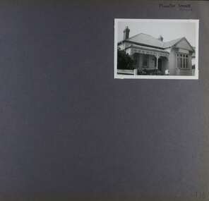
Album - Album page, Inkerman Street, Circa 1972
This photograph is part of the Caulfield Historical Album 1972. This album was created in approximately 1972 as part of a project by the Caulfield Historical Society to assist in identifying buildings worthy of preservation. The album is related to a Survey the Caulfield Historical Society developed in collaboration with the National Trust of Australia (Victoria) and Caulfield City Council to identify historic buildings within the City of Caulfield that warranted the protection of a National Trust Classification. Principal photographer thought to be Trevor Hart, member of Caulfield Historical Society. Most photographs were taken between 1966-1972 with a small number of photographs being older and from unknown sources. All photographs are black and white except where stated, with 386 photographs over 198 pages. Page 101 of Photograph Album with two photographs (landscape) of a house on Inkerman Street.Handwritten: 656 INKERMAN 3/10/1972 [under top left photo] / 101 [bottom left]trevor hart, east st kilda, inkerman street, st kilda east, edwardian, timber, single storey, fretwork, garden, gable, verandahs, architectural feautures, inkerman road, caulfield north -
 Glen Eira Historical Society
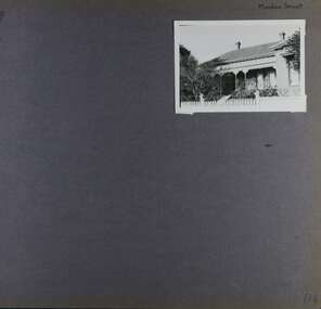
Album - Album page, Meadow Street, Circa 1972
This photograph is part of the Caulfield Historical Album 1972. This album was created in approximately 1972 as part of a project by the Caulfield Historical Society to assist in identifying buildings worthy of preservation. The album is related to a Survey the Caulfield Historical Society developed in collaboration with the National Trust of Australia (Victoria) and Caulfield City Council to identify historic buildings within the City of Caulfield that warranted the protection of a National Trust Classification. Principal photographer thought to be Trevor Hart, member of Caulfield Historical Society. Most photographs were taken between 1966-1972 with a small number of photographs being older and from unknown sources. All photographs are black and white except where stated, with 386 photographs over 198 pages. Page 134 of Photograph Album with one landscape photograph of a Victorian house on Meadow Street.Handwritten: Meadow Street [top right] / 134 [bottom right]trevor hart, east st kilda, decorative brackets, picket fence, slate roof, chimneys, garden, cast iron columns, cast iron frieze, meadow street, st kilda east, caulfield, victorian style, cast iron work, verandahs -
 Glen Eira Historical Society
Album - Album page, Munster Avenue, Circa 1972
This photograph is part of the Caulfield Historical Album 1972. This album was created in approximately 1972 as part of a project by the Caulfield Historical Society to assist in identifying buildings worthy of preservation. The album is related to a Survey the Caulfield Historical Society developed in collaboration with the National Trust of Australia (Victoria) and Caulfield City Council to identify historic buildings within the City of Caulfield that warranted the protection of a National Trust Classification. Principal photographer thought to be Trevor Hart, member of Caulfield Historical Society. Most photographs were taken between 1966-1972 with a small number of photographs being older and from unknown sources. All photographs are black and white except where stated, with 386 photographs over 198 pages. This house continues to occupy the property at 5 Munster Avenue Carnegie (Google map image capture Feb 2019).Page 136 of Photograph Album with one landscape photograph of an Edwardian house on Munster Avenue.Handwritten: Munster Street / Avenue [top right] / 136 [bottom right]trevor hart, garden, verandah, bull nosed verandah, edwardian, coloured glass, corrugated iron roof, bay window, gable, chimneys, porch, munster avenue, carnegie, box bay window, weatherboards, cast iron work, timber houses -
 Glen Eira Historical Society
Album - Album page, Grimwade House, Orrong Road, Circa 1972
This photograph is part of the Caulfield Historical Album 1972. This album was created in approximately 1972 as part of a project by the Caulfield Historical Society to assist in identifying buildings worthy of preservation. The album is related to a Survey the Caulfield Historical Society developed in collaboration with the National Trust of Australia (Victoria) and Caulfield City Council to identify historic buildings within the City of Caulfield that warranted the protection of a National Trust Classification. Principal photographer thought to be Trevor Hart, member of Caulfield Historical Society. Most photographs were taken between 1966-1972 with a small number of photographs being older and from unknown sources. All photographs are black and white except where stated, with 386 photographs over 198 pages. From Victorian Heritage Database citation HO54 Grimwade House, former Harleston stables, outbuilding, garden, gate and Picconia excelsa tree. https://vhd.heritagecouncil.vic.gov.au/places/35573 as at (28/10/2020) ''Harleston'', now "Grimwade House", is situated at no. 67 Balaclava Road, Caulfield North, at the Orrong Road corner. It was built for Frederick, later Sir Frederick, Grimwade, to the design of architect Thomas Watts in 1875. Today the complex has been incorporated in the Melbourne Grammar Junior School campus. It retains not only the main house but also the stables and mature garden setting with driveway and gates. It is historically, aesthetically and socially significant.From Victorian Heritage Database citation HO54 Grimwade House, former Harleston stables, outbuilding, garden, gate and Picconia excelsa tree. https://vhd.heritagecouncil.vic.gov.au/places/35573 as at (28/10/2020) It is historically significant (Criterion A) as the former home of prominent business man, speculator and benefactor, Sir Frederick Grimwade. Both Grimwade and his house are exemplars of the commercial enterprise of the Boom period and the amassing of personal fortunes with which it is associated. It is aesthetically significant (Criterion E) as an imposing yet stately large house of its time, the classic Italian form with comer verandah terminated by projecting wings being most distinctively seen in this instance. It is enhanced not only by the garden setting but also by the delicate cast iron verandah spandrels, stained glass work and stencilled ceiling in the music room. It is socially significant (Criterion G) on account of the value placed on it by the community associated with the Melbourne Grammar Junior School since its inception on this site in 1911.Page 154 of Photograph Album with five photographs (4 landscape and one portrait) including Grimwade House, gates and a tram shelter.Handwritten: Grimwade House (Melbourne Grammar Prep School) / incorporating "Harleston" Orrong Rd. S.E cnr Balaclava Rd [top right] / 154 [bottom right]trevor hart, verandah, porch, slate roof, garden, grimwade house, grimwade, harleston, sir frederick grimwade, thomas watts, orrong road, balaclava road, melbourne grammar, melbourne grammar junior school, italianate, cast iron verandah spandrels, stained glass, stencilled ceiling, mgs, m.g.s, school, grimwade family, jessie grimwade, gates, palisade style fence, cast iron spears, stone plinths, melbourne grammar prep school, victorian style, cast iron work, caulfield north, gardens, cars, tram services, outbuildings, stables, trees, picconia excelsa tree -
 Glen Eira Historical Society
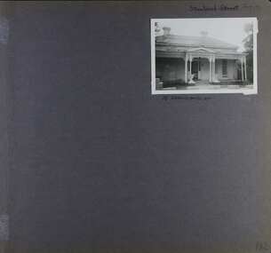
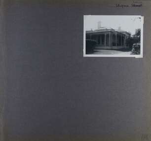
Album - Album page, Staniland Grove, Circa 1972
This album was created in approximately 1972 as part of a project by the Caulfield Historical Society to assist in identifying buildings worthy of preservation. The album is related to a Survey the Caulfield Historical Society developed in collaboration with the National Trust of Australia (Victoria) and Caulfield City Council to identify historic buildings within the City of Caulfield that warranted the protection of a National Trust Classification. Principal photographer thought to be Trevor Hart, member of Caulfield Historical Society. Most photographs were taken between 1966-1972 with a small number of photographs being older and from unknown sources. All photographs are black and white except where stated, with 386 photographs over 198 pages. 15 Staniland Grove is a contributory property to HO72 Elsternwick Estate and environs.Page 192 of Photograph Album with one photograph of a house on Staniland Grove.Handwritten: Staniland Street altered to Staniland Grove [top right] / 15 STANILAND ST [under photo] /192 [bottom right]trevor hart, chimneys, porch, villa residence, garden, verandah, 1890's, late victorian, decorative brackets, cast iron lacework, 1880's, slate roof, single storey, cast iron columns, cast iron frieze, elsternwick, boom period, triangulated pediment, coloured glass, mosaic tiling, complex tiled patterns, pots, italianate, staniland grove, rendered -
 Glen Eira Historical Society
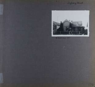
Album - Album page, Sydney Street, Circa 1972
This album was created in approximately 1972 as part of a project by the Caulfield Historical Society to assist in identifying buildings worthy of preservation. The album is related to a Survey the Caulfield Historical Society developed in collaboration with the National Trust of Australia (Victoria) and Caulfield City Council to identify historic buildings within the City of Caulfield that warranted the protection of a National Trust Classification. Principal photographer thought to be Trevor Hart, member of Caulfield Historical Society. Most photographs were taken between 1966-1972 with a small number of photographs being older and from unknown sources. All photographs are black and white except where stated, with 386 photographs over 198 pages. This house has been replaced according to Google image capture Feb 2019.Page 194 of Photograph Album with one photograph of an Edwardian house on Sydney Street, Murrumbeena.Handwritten: Sydney Street [top right] / 16 SYDNEY ST [under photo] / 194 [bottom right]trevor hart, chimneys, porch, garden, verandah, single storey, bull nose verandah, incised weatherboards, edwardian, fretwork, 1900's, return verandah, murrumbeena, sydney street, gardens -
 Glen Eira Historical Society
Album - Album page, Ulupna Road, Circa 1972
This album was created in approximately 1972 as part of a project by the Caulfield Historical Society to assist in identifying buildings worthy of preservation. The album is related to a Survey the Caulfield Historical Society developed in collaboration with the National Trust of Australia (Victoria) and Caulfield City Council to identify historic buildings within the City of Caulfield that warranted the protection of a National Trust Classification. Principal photographer thought to be Trevor Hart, member of Caulfield Historical Society. Most photographs were taken between 1966-1972 with a small number of photographs being older and from unknown sources. All photographs are black and white except where stated, with 386 photographs over 198 pages. Page 196 of Photograph Album with one photograph of a Victorian house on Ulupna RoadHandwritten: Ulupna Street (crossed out) Road [ top right] / 196 [bottom right]trevor hart, chimneys, porch, garden, single storey, return verandah, ulupna road, ormond, decorative brackets, cast iron frieze, cast iron columns, full length windows, villa residence, cast iron work, victorian period -
 Glen Eira Historical Society
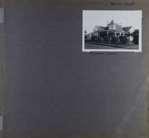
Album - Album page, Wanda Street, Circa 1972
This album was created in approximately 1972 as part of a project by the Caulfield Historical Society to assist in identifying buildings worthy of preservation. The album is related to a Survey the Caulfield Historical Society developed in collaboration with the National Trust of Australia (Victoria) and Caulfield City Council to identify historic buildings within the City of Caulfield that warranted the protection of a National Trust Classification. Principal photographer thought to be Trevor Hart, member of Caulfield Historical Society. Most photographs were taken between 1966-1972 with a small number of photographs being older and from unknown sources. All photographs are black and white except where stated, with 386 photographs over 198 pages. House still in place per Google image capture June 2019. It is Wanda Road, not street. Page 198 of Photograph Album with one photograph of a house on Wanda Street.Handwritten: Wanda Street [top right] / 19 WANDA STREET [under photo] / 198 [bottom right]trevor hart, porch, garden, verandah, single storey, return verandah, decorative brackets, wanda street, ridge capping, spire, protruding bays, decorative fretwork, queen anne style, queen anne, conical tower, wanda road, caulfield north -
 Glen Eira Historical Society
Document - GLEN HUNTLY (HISTORY OF)
This file contains one item: 1/A loose-leaf, 23-page document titled ‘The History of Glen Huntly’, by Alfred R. Jones, dated 20/06/1991, describing the history of the suburb. The author has drawn heavily from the 4 sources noted in the bibliography. Subjects covered include the ship the suburb is named after, the suburb’s State School, the suburb’s churches, the Rosstown Railway and Sugar Mill, the origin of the name of Carnegie, the suburb’s aerodrome, and the beautification of the Glen Huntly Shopping Centre. The final 12 pages consist of 9 appendices relating to the aforementioned subjects. Appendix A is a typewritten letter from Ron McLeod, secretary of the Place Names Committee, to Mr. D. R. Aylen, CEO of the City of Caulfield, notifying the latter of the alteration of the name ‘Glenhuntly’ to ‘Glen Huntly’. Appendix B is a list of the ministers of St. David’s Uniting Church from its formation in 1916 to the present. Appendix C identifies the persons portrayed in St. David’s stained glass windows. Appendix D is a poster announcing the auction of 41 blocks of land between Hawthorn and Bambra Road formerly owned by William Ross, plus a map identifying said land blocks and anither fir locality. Appendix E is an A4 plan of the Rosstown Railway. Appendix F is a drawing of the Rosstown Sugar Mill. Appendix G is a poem titled ‘The Swagman’s Retreat’, by Herb Arnott, about the failure of the Mill. Appendix H is a map of Caulfield’s horse tramways plus a list of opening and closing dates. Appendix J is a list of streets explaining the meanings of their names.glen huntly, glenhuntly, local history, ‘glen huntly’ (ship), ‘glen huntlely’ (ship), quarantine stations, glen huntly road, lake street, mernda avenue, glen huntly state school no. 3703, ormond francis, ormond, garden avenue, grange road, churches, congregational church, glen huntly presbyterian church, st. david’s, st. david’s uniting church, anglican church, jenkin william ‘boss’, methodist church, wattle avenue, smith a. w. mr., glen huntly post office, glen huntly road, king f. l. mr., uniting church, child care centre, presbyterian church of eastern australia, glen huntly methodist church, sun aria, miller mary, stained glass, phrenologists, trinity congregational church, primitive methodists, ‘the victorian independent’, mercy mr., greek orthodox original old calendar church, wanalta road, salvation army, halls, myrtle street, catholic church, st. anthony’s roman catholic church, foundation stones, neerim road, mannix archbishop, st. agnes’ anglican church, booran road, sunday schools, clergy residences, ‘see’ anglican news magazine, lees archbishop, booth archbishop, glen huntly presbyterian church, el nido grove, tennis courts, bollard v. w. right rev., waratah avenue, royal avenue, munster avenue, james street, rothschild street, peace memorial organ, singers, bremner marie, scotland betty, carden joan, rosstown railway, south caulfield, plants, marata road, curraweena road, bambra road, ross william murray, ross leila, ross constance, vautin constance, ‘the grange’, north road, leila road, wild cherry road, caulfield roads board, elsternwick, land sales, sugar mills, koornang road, woornack road, elsternwick railway station, riddell parade, clarence street, dover street, oakleigh road, murrumbeena crescent, carlisle crescent, railways, trains, parks and reserves, caulfield council, sussex street, caulfield city council, swamps, rosstown sugar mill, rosstown estate, ‘the swagman’s retreat’, arnott herb, rosstown, carnegie, ‘ross’s folly’, carnegie andrew, rosstown hotel, dandenong road, rosstown road, rosstown plate horse race, caulfield racecourses, ames avenue, rosstown court, hostels, murrumbeena, cinemas, innovations (cabinetry film), films, music, pianos, manchester grove, safeway store, squash courts, airports, lord reserve, aeroplanes, air navigation act 1921, neville street, larkin sopwith aviation company of australasia, lyons street, morgan street, bookmakers, nightsoil, poultry, weatherboard buildings, glen huntly railway station, rosedale avenue, rifle clubs, scout groups, 1st glen huntly troop, ana, dowding jack mr., glen huntly infant welfare and family planning clinic, vermador private hospital, watson grove, rowlands (drapers), bones plant nursery, caulfield railway station, bridges, trams, horse tramways, glen eira road, elsternwick railway station, kooyong road, aboriginal peoples, truganini road, hannan lyn mrs. (urban planning officer), glen huntly shopping centre, sculptures, street beautification scheme, “flying the yellow flag”, moore olive, “return to rosstown”, jowett d. f., weickhardt i. s., “from sand swamp and health”, murray peter r., wells john c., caulfield historical society, newsletters, place names committee, mcleod ron, aylen d. r. mr., jones hugh rev., king joseph, scarfe james, vertigan sidney, vertigan earle, rance victor, flavell cameron, denholm robin, moorhead ken, taliai siupeli, eccles james leslie, little agnes, hutchins william r., dickie may a., gordon ivey agnes, theobald a. a. mrs., brownbill lloyd norman, ash georgette, land sales, auctions, messrs. crews & arkle, street names -
Glen Eira Historical Society
Letter - MONUMENTS AND NATIONAL REGISTER
This file contains five items pertaining to plaques, memorials and monuments located in Glen Eira: 1/Three letters (1 page each) pertaining to a statue of Isabelle Webb adorning the Caulfield City Hall. The first letter, typewritten, dated 14/07/80, is addressed from J. Pollet, Honorary Secretary of the Caulfield Historical Society, to Mr. G. Calder, City Manager of Caulfield, and announces that the Society has identified the previously unidentified statue and wishes to provide a plaque for it. The second letter, handwritten, dated 20/09/1980, is addressed from Mr. R. Ballantyne of the Caulfield Historical Society to Calder, and laments that the Caulfield City Council has not responded to the first letter. The third letter, typewritten, dated 24/10/1980, is addressed from G. J. Walker, Deputy Manager-Administrator of the City of Caulfield, to Ballantyne, and notifies the latter of the Council’s acceptance of the Society’s offer to provide a plaque. Also included are the invoice and delivery docket for the plaque. 2/A typewritten letter (1 page), dated 26/06/1985, from Norma Polglase, secretary to mayor Brian Rudzki, inviting Mr. and Mrs. R. Ballantyne to an unveiling ceremony at Hopetoun Gardens. 3/A typewritten letter (1 page), dated 05/10/1986, from John Adams, Convenor of the Memorials Committee of the Royal Historical Society of Victoria, to Miss H. Bullock, thanking the latter for her contributions to the Society’s Memorials Project (which presumably consists of the recording of the location of all memorials located in Victoria), and confirming the acknowledgement of four memorials located in Caulfield. 4/A one page typewritten letter, with handwritten note, dated 07/05/1987, from Chilla Bulbeck, project coordinator of the National Register of the Australian Bicentennial Authority, to Mr. R. Ballantyne, thanking the latter for agreeing to act as a recorder for the Project. Attached are 12 pages extrapolating on the Project and a list (2 copies) of monuments thus far acknowledged, although none of this contains anything of relevance specifically to Glen Eira. 5/A typewritten letter, dated 29/11/1996, from Bob Ross, Senior Surveyor of the Geodetic Survey of the Office of the Surveyor General, to the Caulfield Historical Society, requesting the latter’s assistance in identifying any historic survey marks located within Glen Eira, as part of a greater project to identify all such survey marks located within Victoria. Also included is a leaflet extrapolating on the project and featuring a form for documenting survey marks, although this contains nothing of relevance specifically to Glen Eira.glen eira, caulfield, plaques, monuments and memorials, walker g. j., ballantyne r. mr., caulfield historical society, statues, webb isabelle, webb isabella, calder g, pollet j, city of caulfield, caulfield city council, city hall, hawthorn road, glen eira road, neville street, glenhuntly, thompson p. mr., arrow engraving & foundry co., rudzki brian j. p. cr., ballantyne mrs., cannons, festivals and celebrations, invitations, hopetoun gardens, mayors, glenhuntly road, glen huntly road, caulfield city hall, polglase norma, adams john, bullock h. miss, royal historical society of victoria, memorials committee, memorials project, ‘kadimah’, caulfield grammar school, rosstown railway, bambra park, elsternwick, begonia street, gardenvale, bulbeck chilla, australian bicentennial authority, national register of unusual monuments project, jowett memorial drinking fountain, ross bob, office of surveyor general, geodetic survey office of surveyor general -
Glen Eira Historical Society
Article - ELSTERNWICK RAILWAY STATION AND LINE
Contains three items about this: 1/A photocopied article (across 3 long columns) from the Southern Cross newspaper dated 21/07/1928. The article contains details of the opening of the Gardenvale Martin Street subway ceremony. Mention is made of the Caulfield Council’s spontaneous assistance, harmony working alongside Brighton and their financial assistance, as well. Councillor E.F. England (Mayor of Caulfield) attended on behalf of the Caulfield Council. He referred to the large patronage on the Brighton line, also mentioning similar issues for the Elsternwick level crossing. There are brief summaries from the many speakers. The pupils from Gardenvale and Elsternwick schools were congregated around the subway, and the Brighton municipal Brass Band rendered selections. 2/Newspaper clipping (source not stated perhaps Melbourne Sun), ‘Elsternwick to get underpass’, dated 25/02/1959, stating that ‘work has begun to build an underpass that will abolish the Glenhuntly Road level crossing’, with photograph and a map of the level crossing. 3/Handwritten note, signed ‘FEC, 17/11/2006’, headed ‘To be researched – Shooting in foot underpass-policeman killed-murder last man to be hanged in Victoria’, with note on Glenhuntly Road underpass.‘southern cross’, gardenvale progress league, point nepean road, newspapers, caulfield council, north road, ‘made in australia’ week, railways department, parliamentary representative, railway crossings, councillors, gardenvale school, elsternwick school, schools, market gardens, gardenvale progress association, england e.f.(mayor), elsternwick, caulfield, hoyts theatre, theatres, glenhuntly road, elsternwick station, police, murders, executions, shops, elsternwick plaza, petrol stations, ‘the hub’, flats, brothels, ‘the daily planet’ (sic), car parks -
Glen Eira Historical Society
Document - KOOYONG ROAD, 75, CAULFIELD NORTH
Two copies of a pamphlet for the ceremony of the Third Ordnance Services Unit ‘Exercising the Right of the Freedom of Entry to the City of Caulfield’ held on 23/10/1983. The pamphlet includes a brief history of the unit’s association with the City of Caulfield, a list of individuals holding posts within the Unit, text of the scroll conferring the Freedom of Entry on the Unit, a program of the ceremony, a brief history of the Royal Australian Army Ordnance Corps including the Unit’s use of 75 Kooyong Road as their premises, a brief history of the City of Caulfield from 1937-postwar years, and an explanation of the tradition of conferring Freedom of Entry to a city. The pamphlet includes also: 1/A black and white photograph (47x35mm) of the Mayor of Caulfield, W.R. Walters, undated and unattributed. 2/A black and white photograph (81x69mm) of Major A.G. Storen, Commanding Officer of the Third Ordnance Services Unit, undated and unattributed. 3/A color photograph (88x84mm) of the Sovereign’s Banner, undated and unattributed. 4/A black and white copy (137x87mm) of the scroll conferring Freedom of Entry into the City of Caulfield, which was seated August 4 1978. 5/A color illustration (30x32mm) of the City of Caulfield Coat of Arms. 6/A color illustration (40x32mm) of the Third Ordnance Services Unit, Royal Australian Army Ordnance Corps Coat of Arms. 7/A black and white illustration (21x24mm) of the city of Caulfield Coat of Arms. 8/A black and white illustration (19x14mm) of the City of Caulfield badge. 9/A black and white illustration (22x31mm) of the City of Caulfield banner.walters w.r., storen a.g. major, finning d.j. captain, hately p.g. major, davidson j. (captain), swendson r. (second lieutenant), caulfield, city of caulfield, australian army, the third ordnance services unit royal australian army ordnance corps, caulfield park, caulfield council, north caulfield, campton e.j. (brigadier), walters w.r. mrs., calder g.k., calder g.k. mrs., mahon j. (chief superintendent), city hall, balaclava road, hawthorn road, glen eira road, hartley avenue, kooyong road, caulfield racecourse, caulfield town hall, alma road, red cheques cab company, army headquarters printing press, searchlight company, amenities store, armoured replacement unit, first base printing company r.a.a.o.c., garden vale, caulfield railway station, paddy’s swamp, great dandenong road, glen ferrie road, dandenong road, east caulfield reserve, caulfield military hospital, ‘glen eira’, town hall, ‘war office’, caulfield district road board, shire of caulfield, caulfield recruiting committee for volunteers, city repatriation committee, red cross emergency service, women’s national service, mayor’s patriotic fund, promotions committee for war savings certificates, war savings group scheme, ‘the gazette’, air raid precautions committee, orrong road, armed forces, world war 1939-1945, local government, parades and processions, military reserves, world war 1914-1918, councillors, events and activities, historic events, official events, caulfield john, wyne agar, murphy (mayor), hale p., ison (captain), fisher andrew, morris t.w. (mayor) -
Glen Eira Historical Society
Document - KOOYONG ROAD, 75, CAULFIELD NORTH
Three copies of a pamphlet for the ceremony of the Third Ordnance Services Unit ‘Exercising the Right of the Freedom of Entry to the City of Caulfield’, held on 13/07/1986. The pamphlet includes a brief history of the Unit’s association with the City of Caulfield, a list of individuals holding posts within the unit, text of the scroll conferring the Freedom of Entry on the Unit, a program of the ceremony, a brief history of the Royal Australian Army Ordnance Corps, including the Unit’s use of 75 Kooyong Road as their premises, a brief history of the city of Caulfield and an explanation of the tradition of conferring Freedom of Entry to a city. The pamphlet includes also: 1/A black and white photograph (61x66mm) of the Mayor of Caulfield, Maxwell Blair, undated and unattributed. 2/A black and white photograph (70x51mm) of Major P.G. Hateley, Commanding Officer of the Third Ordnance Services Unit, undated and unattributed. 3/A black and white photograph (91x90mm) of the Sovereign’s Banner, undated and unattributed. 4/A black and white copy (137-87) of the scroll conferring Freedom of Entry into the City of Caulfield which was seated August 4 1978. 5/A color illustration (30x32mm) of the City of Caulfield Coat of Arms. 6/A colour illustration (40x32mm) of the Third Ordnance Services Unit, Royal Australian Army Ordnance Corps Coat of Arms. 7/A black and white illustration (21x24mm) of the City of Caulfield Coat of Arms. 8/A black and white illustration (19x19mm) of the City of Caulfield badge. 9/A black and white illustration (22x31mm) of the City of Caulfield banner.blair maxwell (mayor), hateley p.g. (major), finning d.j. (captain), lowe g. (captain), barker l.a. (lieutenant), blair mrs., aylen d.r., aylan d.r. mrs., goltz m.h., compton e.j. (brigadier), goltz m.h. (chief superintendant), caulfield john, wynne agar, murphy (mayor), hate p., ison (captain), fisher andrew, morris t.w. (mayor), caulfield, kooyong road, caulfield park, north caulfield, city of caulfield, city hall, balaclava road, hawthorn road, glen eira road, hartley avenue, caulfield racecourse, caulfield town hall, alma road, orrong road, garden vale, caulfield railway station, paddy’s swamp, great dandenong road, glen ferrie road, dandenong road, east caulfield reserve, caulfield military hospital, ‘glen eira’, town hall, ‘war office’, red chequer cab company, caulfield council, third ordnance services unit royal australian army ordnance corps, australian army, army headquarters printing press, searchlight company, amenities store, armoured replacement unit, first base printing company r.a.a.o.c., caulfield district road board, shire of caulfield, caulfield recruiting committee for volunteers, city repatriation committee, red cross emergency service, women’s national service, mayor’s patriotic fund, promotions committee for war savings certificates, war savings group scheme, ‘the gazette’, air raid precautions committee, armed forces, world war 1939-1945, local government, parades and processions, military reserves, world war 1914-1918, councillors, events and activities, historic events, official events -
Glen Eira Historical Society
Document - Banks in Caulfield
This file contains two items. 1. A hand written list of branches of the English, Scottish and Australian Bank Limited and its merger the Australia and New Zealand Banking Group Limited, undated and author unknown. The list records the opening dates of branches in Carnegie, Caulfield East, Caulfield South, Elsternwick, Glen Huntly, Murrumbeena, Ormond, Garden Vale, Caulfield and Caulfield West encompassing years from 1886 to 1927, listing also the merger of the two banks as being in 1970 as well as 1852 as being the founding year of the English, Scottish, and Australian Bank Limited. 2. Three identical Elsternwick State Savings Bank withdrawal slips, from the 1910s. All three are blank, and include brief directions for filling in the slip typed at the bottom. Also included on the slip is a decorative illustration.banks, banks mergers, bank deposits, bank withdrawals, documents, banking, pass books, business and finance, annual reports, bank equipment, commercial equipment, bank branches, carnegie, carnegie koornang road 86, caulfield east, caulfield east derby road 9, caulfield south, caulfield south glen huntly road 790, elsternwick, elsternwick glen huntly road 324, elsternwick glen huntly road 426, glen huntly, glen huntly glen huntly road 1173, murrumbeena, murrumbeena murrumbeena road 59, ormond, ormond north road, ormond north road 553, garden vale, caulfield, caulfield west, caulfield hawthorn road 242, commercial establishments, the state savings bank of victoria, the state savings bank of victoria elsternwick branch, the english scottish and australian bank limited, the australian and new zealand bank limited, the australian and new zealand banking group limited -
 Glen Eira Historical Society
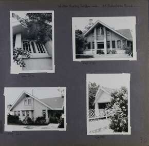
Album - Album page, Balaclava Road, 45, Circa 1972
This photograph is part of the Caulfield Historical Album 1972. This album was created in approximately 1972 as part of a project by the Caulfield Historical Society to assist in identifying buildings worthy of preservation. The album is related to a Survey the Caulfield Historical Society developed in collaboration with the National Trust of Australia (Victoria) and Caulfield City Council to identify historic buildings within the City of Caulfield that warranted the protection of a National Trust Classification. Principal photographer thought to be Trevor Hart, member of Caulfield Historical Society. Most photographs were taken between 1966-1972 with a small number of photographs being older and from unknown sources. All photographs are black and white except where stated, with 386 photographs over 198 pages. While the page heading says "Walter Burley Griffin arch", in fact Edward F. Billson designed it.From the Victorian Heritage Register Database - Citation for 45 Balaclava Road https://vhd.heritagecouncil.vic.gov.au/places/35562 (as at 12/10/2020) The house at 45 Balaclava Road, Caulfield North has architectural importance as an early example of the work of Edward F. Billson, whose work demonstrated the influence of the internationally distinguished American architect Frank Lloyd Wright and his one time colleague, Walter Burley Griffin with whom Billson worked in partnership for a period. It is presumed to be the earliest important example Billson's work and attains special importance as an early example of modern architecture in Australia, the earliest work of Griffin preceding it by only five years.Page 30 of Photograph Album with three photographs of the exterior of this double storey house and one photograph of a carport.Handwritten: Walter Burley Griffin arch. 45 Balaclava Road [top right] / Neg 272 [under top left photo] / Neg 270 [under top right photo] / Neg 262 [under bottom left photo] / Neg 264 [under bottom right photo] / 30 [bottom right] trevor hart, caulfield north, balaclava road, edward f. billson, frank lloyd wright, walter burley griffin, modern architecture, 1910's, gables, double storey houses, windows, attics, carports, gardens -
 Glen Eira Historical Society
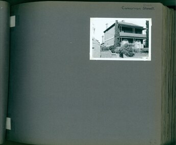
Album - Album page, Carnarvon Road, Circa 1972
This photograph is part of the Caulfield Historical Album 1972. This album was created in approximately 1972 as part of a project by the Caulfield Historical Society to assist in identifying buildings worthy of preservation. The album is related to a Survey the Caulfield Historical Society developed in collaboration with the National Trust of Australia (Victoria) and Caulfield City Council to identify historic buildings within the City of Caulfield that warranted the protection of a National Trust Classification. Principal photographer thought to be Trevor Hart, member of Caulfield Historical Society. Most photographs were taken between 1966-1972 with a small number of photographs being older and from unknown sources. All photographs are black and white except where stated, with 386 photographs over 198 pages. This house is part of HO14 Caulfield North and Environs - Heritage Overlay as a contributing property.Page 42 of Photograph Album with one photograph of a double-storey house on Carnarvon Road.Handwritten: Carnarvon Road [top right hand corner] / 42 [bottom right]trevor hart, caulfield north, carnarvon road, houses, verandahs, balconies, gardens -
 Glen Eira Historical Society
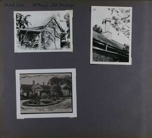
Album - Album page, Hood Cresc - St Mary's Old Vicarage, Circa 1972
This photograph is part of the Caulfield Historical Album 1972. This album was created in approximately 1972 as part of a project by the Caulfield Historical Society to assist in identifying buildings worthy of preservation. The album is related to a Survey the Caulfield Historical Society developed in collaboration with the National Trust of Australia (Victoria) and Caulfield City Council to identify historic buildings within the City of Caulfield that warranted the protection of a National Trust Classification. Principal photographer thought to be Trevor Hart, member of Caulfield Historical Society. Most photographs were taken between 1966-1972 with a small number of photographs being older and from unknown sources. All photographs are black and white except where stated, with 386 photographs over 198 pages. Page 87 of Photograph Album with two photographs (portrait and landscape) plus a photo of a photograph of St Mary's Old Vicarage.Handwritten: Hood Cres St Mary's Old Vicarage[top left] / bottom photo of photograph is titled "St Mary's Vicarage" / 87 [bottom left]trevor hart, elsternwick, hood crescent, helenslea, c.e.g.g.s., school, 1860's, sir george stephen, shelford, glen eira road, st mary's vicarage, st mary's old vicarage, vicarage, church of england, gardens, chimneys, caulfield north -
 Glen Eira Historical Society
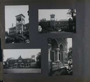
Album - Album page, Ripponlea, 192 Hotham Street, Circa 1972
This photograph is part of the Caulfield Historical Album 1972. This album was created in approximately 1972 as part of a project by the Caulfield Historical Society to assist in identifying buildings worthy of preservation. The album is related to a Survey the Caulfield Historical Society developed in collaboration with the National Trust of Australia (Victoria) and Caulfield City Council to identify historic buildings within the City of Caulfield that warranted the protection of a National Trust Classification. Principal photographer thought to be Trevor Hart, member of Caulfield Historical Society. Most photographs were taken between 1966-1972 with a small number of photographs being older and from unknown sources. All photographs are black and white except where stated, with 386 photographs over 198 pages.From Victorian Heritage Database citation for Rippon Lea H0614 https://vhd.heritagecouncil.vic.gov.au/places/427(as at 23/10/2020) Rippon Lea was commenced in 1868 by Frederick Sargood, a most successful politician and merchant. He was born in England in 1834 and arrived in Melbourne in 1850. He soon joined his father's wholesale soft goods firm, spending some time as its manager on the goldfields. Sargood entered the Legislative Council in 1874. He was Victoria's first Minister for Defence in 1883. Sir Frederick Sargood was created CMG. In 1885 and KCMG in 1890 as a reward for his contribution to public life. He died suddenly in 1903. Rippon Lea was designed by the leading firm of architects, Reed and Barnes. Joseph Reed had travelled in Europe in 1863, including northern Italy. When he returned he introduced the use of polychromy. While not the first examples, Rippon Lea and the Independent Church in Collins Street were the best and set a fashion which became a distinctly Melbourne style, particularly used for houses and churches. Its popularity was possible because of the new availability of different coloured bricks. Reed's fine Lombardic Romanesque details soon became debased by others. As Sargood's family grew and his fortunes prospered, Rippon Lea was extended to include 33 rooms - a complete mansion. The cast iron porte cochere and the northern conservatory were added in 1897. The architects were Taylor and Fitts. The ballroom was added in 1882 and remodelled in 1889. Many alterations have changed the interior and exterior during the ownerships of Benjamin Nathan and later his daughter Mrs Louisa Jones in the 1930s and are in their own right of significance. Sir Thomas Bent owned the property from 1903 until 1911 but never lived there. He subdivided much of the land. The original garden dates from about 1868, and it seems that William Guilfoyle of the Botanic Gardens was involved. It was redesigned in a more natural style in the 1880s by Sargood and his head gardener, Adam Anderson. The lake, waterfalls, fernery, hill and grotto are balanced by mighty deciduous trees and conifers. These are interspersed with, but never dominated by Australian species such as eucalyptus and other exotics. The sinuous drive with its carefully prepared approach to the house is notable. The original vegetable gardens, orchard and outer paddocks no longer survive. The shade house is important as the largest known in Australia and possibly the world. Its curved plan and form of construction are particularly notable. It was built about 1884.Page 90 of Photograph Album with five photographs (one landscape and 4 portrait) of Ripponlea - two different views of the front entrance to the mansion, one of the front gates and two different views of the main residence.Handwritten: "Ripponlea" 192 Hotham Street [top right] / North [under top left photo] / Neg 255 Dec 1972 MAIN DRIVE [under bottom left photo] / Neg 238 8 OCT 1966 [under middle right photo] / 88 [bottom right]trevor hart, elsternwick, mansion, hotham street, frederick sargood, reed and barnes, cast iron porte cochere, conservatory, 1860's, 1890's, ballroom, 1880's, benjamin nathan, louisa jones, thomas bent, sir thomas bent, william guilfoyle, adam anderson, lake, grotto, shade house, portico, ripponlea, victorian, sir frederick sargood, architects, polychrome bricks, lombardic romanesque architectural style, rippon lea, taylor and fitts, land subdivisions, gardens, drives, vegetable gardens, orchards -
 Glen Eira Historical Society
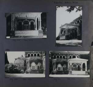
Album - Album page, Ripponlea, 192 Hotham Street, Circa 1972
This photograph is part of the Caulfield Historical Album 1972. This album was created in approximately 1972 as part of a project by the Caulfield Historical Society to assist in identifying buildings worthy of preservation. The album is related to a Survey the Caulfield Historical Society developed in collaboration with the National Trust of Australia (Victoria) and Caulfield City Council to identify historic buildings within the City of Caulfield that warranted the protection of a National Trust Classification. Principal photographer thought to be Trevor Hart, member of Caulfield Historical Society. Most photographs were taken between 1966-1972 with a small number of photographs being older and from unknown sources. All photographs are black and white except where stated, with 386 photographs over 198 pages.From Victorian Heritage Database citation for Rippon Lea H0614 https://vhd.heritagecouncil.vic.gov.au/places/427(as at 23/10/2020) Rippon Lea was commenced in 1868 by Frederick Sargood, a most successful politician and merchant. He was born in England in 1834 and arrived in Melbourne in 1850. He soon joined his father's wholesale soft goods firm, spending some time as its manager on the goldfields. Sargood entered the Legislative Council in 1874. He was Victoria?s first Minister for Defence in 1883. Sir Frederick Sargood was created CMG. In 1885 and KCMG in 1890 as a reward for his contribution to public life. He died suddenly in 1903. Rippon Lea was designed by the leading firm of architects, Reed and Barnes. Joseph Reed had travelled in Europe in 1863, including northern Italy. When he returned he introduced the use of polychromy. While not the first examples, Rippon Lea and the Independent Church in Collins Street were the best and set a fashion which became a distinctly Melbourne style, particularly used for houses and churches. Its popularity was possible because of the new availability of different coloured bricks. Reed's fine Lombardic Romanesque details soon became debased by others. As Sargood's family grew and his fortunes prospered, Rippon Lea was extended to include 33 rooms - a complete mansion. The cast iron porte cochere and the northern conservatory were added in 1897. The architects were Taylor and Fitts. The ballroom was added in 1882 and remodelled in 1889. Many alterations have changed the interior and exterior during the ownerships of Benjamin Nathan and later his daughter Mrs Louisa Jones in the 1930s and are in their own right of significance. Sir Thomas Bent owned the property from 1903 until 1911 but never lived there. He subdivided much of the land. The original garden dates from about 1868, and it seems that William Guilfoyle of the Botanic Gardens was involved. It was redesigned in a more natural style in the 1880s by Sargood and his head gardener, Adam Anderson. The lake, waterfalls, fernery, hill and grotto are balanced by mighty deciduous trees and conifers. These are interspersed with, but never dominated by Australian species such as eucalyptus and other exotics. The sinuous drive with its carefully prepared approach to the house is notable. The original vegetable gardens, orchard and outer paddocks no longer survive. The shade house is important as the largest known in Australia and possibly the world. Its curved plan and form of construction are particularly notable. It was built about 1884.Page 91 of Photograph Album with four photographs (two portrait and two landscape) of various external views of Ripponlea.Handwritten: SOUTH [under top left photo] / SOUTH [under top right photo] / WEST [under bottom left photo] / 91 [bottom left]trevor hart, elsternwick, mansion, hotham street, frederick sargood, reed and barnes, cast iron porte cochere, conservatory, 1860's, 1890's, ballroom, 1880's, benjamin nathan, louisa jones, thomas bent, sir thomas bent, william guilfoyle, adam anderson, lake, grotto, shade house, portico, ripponlea, victorian, sir frederick sargood, architects, taylor and fitts, rippon lea, polychrome bricks, lombardic romanesque style -
 Glen Eira Historical Society
Album - Album page, Ripponlea, Hotham Street, Circa 1972
This photograph is part of the Caulfield Historical Album 1972. This album was created in approximately 1972 as part of a project by the Caulfield Historical Society to assist in identifying buildings worthy of preservation. The album is related to a Survey the Caulfield Historical Society developed in collaboration with the National Trust of Australia (Victoria) and Caulfield City Council to identify historic buildings within the City of Caulfield that warranted the protection of a National Trust Classification. Principal photographer thought to be Trevor Hart, member of Caulfield Historical Society. Most photographs were taken between 1966-1972 with a small number of photographs being older and from unknown sources. All photographs are black and white except where stated, with 386 photographs over 198 pages.From Victorian Heritage Database citation for Rippon Lea H0614 https://vhd.heritagecouncil.vic.gov.au/places/427(as at 23/10/2020) Rippon Lea was commenced in 1868 by Frederick Sargood, a most successful politician and merchant. He was born in England in 1834 and arrived in Melbourne in 1850. He soon joined his father's wholesale soft goods firm, spending some time as its manager on the goldfields. Sargood entered the Legislative Council in 1874. He was Victoria?s first Minister for Defence in 1883. Sir Frederick Sargood was created CMG. In 1885 and KCMG in 1890 as a reward for his contribution to public life. He died suddenly in 1903. Rippon Lea was designed by the leading firm of architects, Reed and Barnes. Joseph Reed had travelled in Europe in 1863, including northern Italy. When he returned he introduced the use of polychromy. While not the first examples, Rippon Lea and the Independent Church in Collins Street were the best and set a fashion which became a distinctly Melbourne style, particularly used for houses and churches. Its popularity was possible because of the new availability of different coloured bricks. Reed's fine Lombardic Romanesque details soon became debased by others. As Sargood's family grew and his fortunes prospered, Rippon Lea was extended to include 33 rooms - a complete mansion. The cast iron porte cochere and the northern conservatory were added in 1897. The architects were Taylor and Fitts. The ballroom was added in 1882 and remodelled in 1889. Many alterations have changed the interior and exterior during the ownerships of Benjamin Nathan and later his daughter Mrs Louisa Jones in the 1930s and are in their own right of significance. Sir Thomas Bent owned the property from 1903 until 1911 but never lived there. He subdivided much of the land. The original garden dates from about 1868, and it seems that William Guilfoyle of the Botanic Gardens was involved. It was redesigned in a more natural style in the 1880s by Sargood and his head gardener, Adam Anderson. The lake, waterfalls, fernery, hill and grotto are balanced by mighty deciduous trees and conifers. These are interspersed with, but never dominated by Australian species such as eucalyptus and other exotics. The sinuous drive with its carefully prepared approach to the house is notable. The original vegetable gardens, orchard and outer paddocks no longer survive. The shade house is important as the largest known in Australia and possibly the world. Its curved plan and form of construction are particularly notable. It was built about 1884.Page 92 of Photograph Album with four photographs (three landscape and one portrait) of Ripponlea - views of entrance and left front of mansion.Handwritten: "Ripponlea" Hotham Street [top right] / Neg 245 Dec 1972 [under top left photo] / Neg 246 Dec 1972 [under bottom left photo] / Neg 247 Dec 1972 [under bottom right photo] / 92 [bottom right]trevor hart, elsternwick, mansion, hotham street, frederick sargood, reed and barnes, lombardic, romanesque, cast iron porte cochere, conservatory, 1860's, 1890's, ballroom, 1880's, benjamin nathan, louisa jones, thomas bent, sir thomas bent, william guilfoyle, adam anderson, lake, grotto, shade house, portico, ripponlea, victorian, sir frederick sargood, architects, polychrome bricks, lombardic romanesque style, rippon lea, entrances -
 Glen Eira Historical Society
Album - Album page, Ripponlea, Hotham Street, Circa 1972
This photograph is part of the Caulfield Historical Album 1972. This album was created in approximately 1972 as part of a project by the Caulfield Historical Society to assist in identifying buildings worthy of preservation. The album is related to a Survey the Caulfield Historical Society developed in collaboration with the National Trust of Australia (Victoria) and Caulfield City Council to identify historic buildings within the City of Caulfield that warranted the protection of a National Trust Classification. Principal photographer thought to be Trevor Hart, member of Caulfield Historical Society. Most photographs were taken between 1966-1972 with a small number of photographs being older and from unknown sources. All photographs are black and white except where stated, with 386 photographs over 198 pages.From Victorian Heritage Database citation for Rippon Lea H0614 https://vhd.heritagecouncil.vic.gov.au/places/427(as at 23/10/2020) Rippon Lea was commenced in 1868 by Frederick Sargood, a most successful politician and merchant. He was born in England in 1834 and arrived in Melbourne in 1850. He soon joined his father's wholesale soft goods firm, spending some time as its manager on the goldfields. Sargood entered the Legislative Council in 1874. He was Victoria?s first Minister for Defence in 1883. Sir Frederick Sargood was created CMG. In 1885 and KCMG in 1890 as a reward for his contribution to public life. He died suddenly in 1903. Rippon Lea was designed by the leading firm of architects, Reed and Barnes. Joseph Reed had travelled in Europe in 1863, including northern Italy. When he returned he introduced the use of polychromy. While not the first examples, Rippon Lea and the Independent Church in Collins Street were the best and set a fashion which became a distinctly Melbourne style, particularly used for houses and churches. Its popularity was possible because of the new availability of different coloured bricks. Reed's fine Lombardic Romanesque details soon became debased by others. As Sargood's family grew and his fortunes prospered, Rippon Lea was extended to include 33 rooms - a complete mansion. The cast iron porte cochere and the northern conservatory were added in 1897. The architects were Taylor and Fitts. The ballroom was added in 1882 and remodelled in 1889. Many alterations have changed the interior and exterior during the ownerships of Benjamin Nathan and later his daughter Mrs Louisa Jones in the 1930s and are in their own right of significance. Sir Thomas Bent owned the property from 1903 until 1911 but never lived there. He subdivided much of the land. The original garden dates from about 1868, and it seems that William Guilfoyle of the Botanic Gardens was involved. It was redesigned in a more natural style in the 1880s by Sargood and his head gardener, Adam Anderson. The lake, waterfalls, fernery, hill and grotto are balanced by mighty deciduous trees and conifers. These are interspersed with, but never dominated by Australian species such as eucalyptus and other exotics. The sinuous drive with its carefully prepared approach to the house is notable. The original vegetable gardens, orchard and outer paddocks no longer survive. The shade house is important as the largest known in Australia and possibly the world. Its curved plan and form of construction are particularly notable. It was built about 1884.Page 93 of Photograph Album with four photographs (two landscape and two portrait) of Ripponlea - lake and gardens.Handwritten: Neg 239 Dec 1973 LAKE [under top left photo] / Neg 242 Dec 1973 FERN HOUSE [under top right photo] / Neg 243 Dec 1972 FERN HOUSE [under bottom left photo] / Neg 241 Dec 1972 LAKE [under bottom right photo] / 93 [bottom left]trevor hart, elsternwick, mansion, hotham street, frederick sargood, sargood, reed and barnes, 1860's, 1890's, 1880's, benjamin nathan, nathan, louisa jones, thomas bent, sir thomas bent, william guilfoyle, adam anderson, lake, grotto, shade house, portico, ripponlea, victorian, sir frederick sargood, architects, taylor and fitts, rippon lea, gardens, ferns, bridges, walking trails -
Glen Eira Historical Society
Newsletter - ROTARY CLUB OF GLEN EIRA
This file contains six items pertaining to the Rotary Club of Glen Eira: 1/The 1996-7 bulletin of the Club. Contains the address and phone number of the Club, a brief history of Glen Eira, a list of the times and locations of the meetings of both the Glen Eira branch and others in Melbourne, and a list of present and past faculty. 2/A typewritten letter, dated 21/03/1997, from Geoff Oscar, former president of the Club, to Mrs. Felicitie Campbell of the Caulfield Historical Society, thanking the latter for an address delivered to the Club on 18/03. 3/Bulletin #38 of the Club, which principally describes a meeting held at 29/04/1997. Features a duty roster, an advance program, a description of a presentation about ANZAC Day to be delivered at the meeting by Ross Bastiaan, a description of a presentation about great cities of the world delivered at the previous meeting by Peter Shellie, a poem about ANZAC Day, notifications of various upcoming events, and an attendance report. Also attached is a an extract from Victorian Railways to ’62 by Leo J. Harrigan describing the history of the Rosstown Railway. 4/Two copies of a booklet announcing the 21st birthday celebration dinner of the Club, to be held on 11/11/2008. Included is the menu, program of events, and a list of past presidents of the Club. 5/A booklet, dated 2009, providing basic information about the Club, including its address, meeting time, contact details, mission statement, faculty, past presidents, calendar and a brief history. 6/A card announcing the 21st Annual Business Person’s Breakfast, to be held at Glen Eira Town Hall on 12/03/2010, featuring David Smorgon as guest speaker.glen eira, rotary club of glen eira, clubs and associations, st. georges road, elsternwick, local history, ricketson henry, watts thomas, architects, ‘glen eira’, mansions, house names, australian general military hospital no. 11, alfred hospital, southern memorial hospital, graham jeremy, james barry, langfelder kurt, fookes marc, asher geoff, süssmann jacques, flores denis, strong john, sylvester bill, oscar geoff, cohen peter, leske john, sharp merv, ray alf, nettelbeck david, sherlock max, rattray john, pollock david, smith barry, harris paul, britten elizabeth, jacobs frank, campbell felicitie mrs., caulfield historical society, scout groups, dover street, north road, trams, ripponlea, market gardens, chinese community, nepean highway, glen eira road, caulfield grammar, horses, edinburgh avenue, bastiaan ross dr., zazryn ben, schwartz roy, nathan vic, stewart ron, sharp hiam, bendel david, steven john, turner brian, shellie peter, warren r., dalidakis g., silvester b., brain judy, stuckey hugh, solomon john, sloman felicity, anzac day, ‘anzac day poem’, stockdale alan, pfau leon, caulfield races, fundraising events, rotary club of caulfield-rosstown, rosstown sugar mill, banners, ‘victorian railways to ‘62’, harrigan leo j., rosstown railway, railways, business and finance, ross william murray, ‘the grange’, caulfield, rosstown junction railway and property co., rosstown railway abandonment act 1916, rosstown, carnegie, rosstown road, festivals and celebrations, kooyong lawn tennis club, food, heuberger david, harambee choir, mcinnes ray archdeacon, muir colin, aarons joseph, nagaoka ryo, miwa takashi, sheezel robert, matheson judy, marks ian, nelson adrian, blode larry, the london tavern, hawthorn road, binstock sam, hill jan, faiman keith, nirens jeff, preston mark, fabian garry, dimand jack, silvester bill, city of glen eira town hall, annual business person’s breakfast, smorgon david -
 Federation University Historical Collection
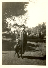
Photograph - black and white, Sarah Wright at the Ballarat Botanical Gardens
Sarah Wright was the mother of Frank Wright who was a renown resident of Smeaton, where he was born. He lived at Laura Villa, and attended Smeaton State School. His father William was a gold miner. Their family won many singing and instrumental awards. Frank was tutored by Percy Code and became the Australian Open Cornet Champion by the age of eighteen. A year later, Frank conducted the City of Ballarat Band, and later the Ballarat Soldiers’ Memorial Band. He formed the Frank Wright Frisco Band and Frank Wright and his Coliseum Orchestra. These bands won many South Street awards, and Frank as conductor won many awards in the Australian Band Championship contest. In 1933 Frank Wright sailed to England to conduct the famous St Hilda’s Band and was later appointed Musical Director of the London County Council, where he organized many amazing concerts in parks, in and around the London district. He was made Professor of Brass and Military Band Scoring and conducted at the Guildhall of Music and Drama. Frank was often invited to adjudicate Brass Band Championships around Europe, in Australia, including South Street and in New Zealand. The Frank Wright Medal at the Royal South Street competition is awarded to an individual recognized as making an outstanding contribution to brass music in Australia.Black and white photograph of a woman in a dark dress and hat and carrying an umbrella. She is standing on a path set within the grounds of the Ballarat Botanical Gardens, with the Statue Pavillion, a statue, shrubs and large trees in the background. The woman is Sarah Wright.sarah wright, frank wright, ballarat botanical gardens, statue pavillion -
 Federation University Historical Collection
Photograph, Noel L. Harvey, Yendon Railway Station, 1968, 03/12/1968
Buninyong had no railway station so residents would travel to Yendon to catch the train. The Yendon Railway Station building was demolished soon after this photograph was taken. The bluestone was purchased by John Vernon, and was used to construct retaining walls in a garden enclosure between the first two buildings at the new Ballarat Institute of Advanced Education campus at Mt Helen. This is now known as the courtyard between building 'F' and building 'G' at the University of Ballarat mt Helen Campus. The following article was published in the Ballarat Courier on 06 December 1968. 'Yendon Station to be demolished - The old bluestone railway station at Yendon is to be demolished. C.A.D. Fisken told Buninyong Shire Council of the proposal at its meeting yesterday. Fortunately, he said, the beautiful stonework would not be lost. It would be used and incorporated in the new School of Mines building at Mt Helen. the retention of the century-old building was the subject of representations by Council to the Railways following the closure of the station for goods traffic 'some time ago'. The building had also been noted by the National Trust as one of special interest. The Railways Department advised the meeting that an inspection had been made at the Yendon level crossing, but no recommendation could be made at present for installation of flashing light signals.'Bluestone building with dressed bluestone door and window jambs and chimney. The roof is corrugated iron. The platform edge is also of bluestone construction. The building is the former Yendon Railway Station (now demolished) on the Ballarat -Geelong main line (the original Melbourne to Ballarat mainline). When the line was opened, this station may have been originally called Buninyong as it was built a number of years before the Ballarat to Buninyong branch line was built. This this has subsequently caused some confusion. The station was later renamed Yendon. Verso in blue ballpoint pen 'No 47 Yendon Railway Stn' Stamped in purple ink 'N.L. Harvey & Son, Photographers, 131 Sturt Streeet Ballarat, Phone 25766, After hours 23397, Will photograph anywhere anytime any place. (in pen 3/12/68),university of ballarat, ballarat institute of advanced education, yendon, railway, bluestone, john vernon -
 Federation University Historical Collection
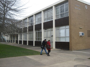
Photograph - Photograph - Colour, Clare Gervasoni, University of Ballarat 'G' Buildings Courtyard and Interior, 26/08/2009
The buildings and courtyards shown in this collection of photographs are the first buildings at the new educational facility at Mt Helen. Students first started using the facility in 1970.Nine colour photographs showing the courtyard between the first two buildings at the University of Ballarat (then Ballarat Institute of Education). .1) and .2) show 'G' building interiors .3) to .5) show the 'G' building courtyard looking towards 'F' building. The bluestone garden retaining walls are bluestone from the former Yendon Railway Station. .7) 'F' building exterior looking to the site of the first library at Mt Helen (in Building 'F') .8) and .9) are 'G' building lecture theatresuniversity of ballarat, ballarat institute of advanced education, yendon, railway, bluestone.ballarat school of mines stamper battery, mount helen campus, brutalism -
 Federation University Historical Collection
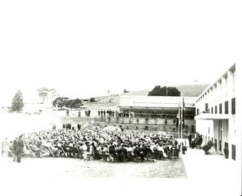
Photograph, Noel L. Harvey & Son, Official Opening of the University of Ballarat Mt Helen Campus, 31/10/1970
The first building completed at the Mt Helen Campus was "G" Building, and is depicted in this photograph. An overview of the development of the Ballarat Institute of advanced Education (BIAE) is given on the program of the official opening of Mt Helen campus (Cat. No. 1086)Black and white photographs showing the opening ceremony for the University of Ballarat Mount Helen Campus. .1) The audience at the opening of the University of Ballarat Mount Helen campus. The pile of bluestone in the background is most probably bluestone from the Yendon Railway Station. .4) Nigel Bowen, at the microphone stands in front of a new building, with a seated audience in front of him. The bluestone retaining wall was erected from bluestone retrieved from the newly demolished Yendon Railway Station. The Ballarat Brass Band is seated undercover in the background. .6) A number of people seated watching a man give a speech in front of a new building. The man is The Hon. Nigel Bowen, Q.C., M.P., Commonwealth Minister for Education and Science. The building is the first building at the Mt Helen Campus of the University of Ballarat. the bluestone retaining wall used bluestone retrieved after the demolition of the Yendon Railway Station. 26.0 x 26.0 cm.1-3) verso "Tippett" Photographers stampuniversity of ballarat, ballarat college of advanced education, yendon, yendon railway station, mb john, jack barker, nigel bowen, rolly perfenovics, mount helen campus, ballarat brass band, bluestone, garden -
 Federation University Historical Collection
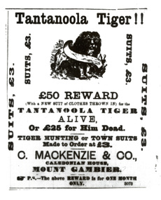
Newspaper - Newsclippings, Tantanoola Tiger Newsclippings
In the early 1880s a small circus travelled between Millicent and Mt Gambier, South Australia. After camping overnight they discovered their Bengal Tiger at escaped and disappeared into dense scrub. After searching for hours they continued to Mt Gambier and reported the loss of the tiger to police. Police and local volunteers continued the search for the escaped tiger, but no sighting were made. In the early 1890s sheep in the Tantanoola area started to disappear with the still unsighted tiger being blamed. In 1893 reports of an unusual animal in the Tantanoola area started, with many describing the animal as the missing tiger, or a large dog. One eye witness claimed to have seen the animal carrying a full grown sheep in its mouth. The reports grew in number and exaggeration with sightings from Robe to Bendigo. In the Tantanoola district children were escorted with shotgun guards to and from school, with many homes keeping guns at the ready in case the tiger suddenly appeared. In August 1895 Tom Donovan shot the "Tantanoola Tiger" on Mt Salt Station, around 20 kms south of Tantanoola. The corpse was taken to Marks, a Mount Gambier taxidermist, at which time the animal was identified as an Assyrian or Northern Russian Wolf. Donovan displayed the animal far and wide. Despite the animal's death sheep continued to disappear from properties in the district over many years. It was of particular concern between 1909 and 1910. At that time Herbert Allchurch, an Adelaide detective, was sent to solve the mystery. A few days after his arrival Allchruch went to the front bar of the Tiger Hotel and arrested local rabbit shooter and trapper, Charlie Edmunson, with sheep stealing. After his 1911 trial Edmunson admitted to stealing over 4,000 sheep during the previous 20 years. He was gaoled for six years with hard-labour in January 1911. Edmunson had been selling the skins of the stolen sheep, leaving the carcusses to rot. He earned around five pounds per week during the 1990s and early 1900s, a time when the economy was depressed. It is not known had the animal known as the Tantanoola Tiger came to Australia, but it is believed it survived one of three ships wrecked of the coast between 1890 and 1893, making it to shore along with some of the shipwrecked passengers. (From a card produced by the Tantanoola Tiger Hotel, where the 'tiger' is on display.)A collection of Newsclippings from 1892 - 1895 photocopied onto A4 white paper. The clippings relate to the Tantanoola Tiger. Clippings include: * Border Watch 1892 - Tantanoola Tiger Reward * Sydney Morning Herald, 04/07/1857 - Animals in Zoological Gardens, including a number of large cats. * Claims the Tantanoola Tiger was an escaped circus animal (ie The Advertiser [Adelaide], 31 October 1893) * Search parties for the Tantanoola Tiger (ie Barrier Miner 19/05/1893; Barrier Miner 03/1081893) * Thylacine claim (ie Morning Bulletin [Rockhampton] 11/03/1895 * Afghan and Indian Hunters (ie Barrier Miner 07/02/1895) * Sighting by John Bird of Scarsdale - Wanganui Herald 15/12/1900. " ... Mr Bird was travelling on foot along a lonely track through very dense scrub, when he was stricken with amazement to see a full-grown tiger standing in a small dam about 30ft away, and holding in its jaws the carcass of a newly-killed lamb. He remained long enough to thoroughly take in the animals appearance, and then beat a hasty retreat unmolested. His description of the animal is as follows: A tawny-coloured creature, with a dirty mottled skin; in general appearance like an immense cat; body 4ft long, and of a uniform thickness from shoulder to hindquarters; in bulk equal to a very large pig. The legs were hidden in the water. A similar animal is reported to gave been seen near Canico, some miles away. ..." * Victorian country sightings # Bullarto - Argus 06/05/1905 # Dean - Launceston Examiner 28/01/1895 # Bendigo - Hobart Mercury 15/03/1895 # Ballan - Launceston Examiner 03/08/1895 * South Australian register 17/06/1885 " There is a tiger or panther wandering at large in Victoria, according to a rumour. It has taken the place of the Bunyip, whom hundreds have seen but none captured. This tiger is supposed to have broken loose from a travelling menagerie in the North-eastern district. At the beginning we should like it roved that such an escape ever took place. Perhaps the showmen were afraid to report the fact to the police; at any rate they did not do so. The first story about the tiger being seen came from the neighborhood of Wangaratta, 60 miles from the place where it is said to have commenced business on its own account. He was followed, but vanished among trees. Next we hear of a strange animal, bigger than a St Bernard's dog, but shorter legged, having appeared at least 150 miles from Wangaratta. Between Lilydale and Wangaratta there is a dividing range 2,000 feet high in the lowest past, besides several large rivers. An finally, the tiger - changed from a panther - is reported as having been seen within the suburban circle, about 8 miles from the general Post Office. They show you footprints, and point to the carcasses of mangled cows and calves. Casts have been taken of the footprints for examination by scientific men, who pronounce them doglike, and yet not doglike, but panther-like, which gives a nervous turn, for the panther may take up killing children and grown-up people. One tiger will not account for so many apparitions. There must have been a general strike among the menageries, and a breaking-up companies. ... * Research article by Philip A. Clarke "Indigenous Spirit and Ghost Folklore of 'Settled' Australia. australian animal folklore collection, tantanoola tiger, tom donovan, herbert allchurch, charles edmunson, sheep, charlie edmunson, mythical, myth, folklore -
 Federation University Historical Collection
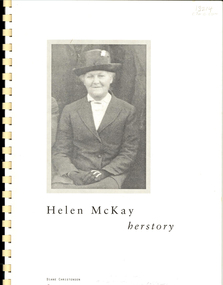
Booklet, Helen McKay Herstory, 1997
Helen McKay was a foundation member of the Eureka Stockade Progress Association, and later a life member. The Eureka Stockade Memorial Park comprised a monument to those killed in the Battle of Eureka in 3 December 1854, gardens, swimming pool, waterlily pond, hall and memorial gates. The gateway, on Stawell Street Ballarat, is dedicated to Helen McKay. Helen Maria (Helen) Reddie was the first Australian born child of William Reddie and his wife Christiana. Before emigrating to Australia they had lived in Kilcaldy, Fifeshire, Scotland.49 page A4 booklet with plastic cover and plastic binding with information relating to Helen McKay. eureka, eureka stockade, eureka stockade progress association, eureka memorial, mckay, helen mckay, scotland, scottish, george main, buninyong, thomas hiscock, trial mills, di christensen -
 Federation University Historical Collection
Photograph - Photograph Album, Photographs of Ballarat Buildings, 1967, 1967
When these photos were taken Geoffrey Biddington was highly involved with the Ballarat Branch of the National Trust. At one time Her Majesty's Theatre was known as the Memorial Theatre. Lenaghan of Tourello "Master Dan Lenaghan, eldest son of Mr. and Mrs. R. Lenaghan, of Tourello, has been successful in obtaining a Government scholarship, tenable for four years at St. Patrick's College, Ballarat.(Melbourne Advocate, 02 March 1939) Two Black folders of Ballarat photographs as follows: .1) Interior of Ballarat Railway Station .2) Interior of Ballarat Railway Station .3) Craig's Hotel .4) Craig's Hotel .5) Craig's Hotel .6) Craig's Hotel .7) Ballarat Fine Art Gallery later Art Gallery of Ballarat .8) Cuthberts, corner Lydiard and Mair Streets .9) Golden City Hotel (GCs) .10) Golden City Hotel (GCs) .11) Reid's Coffee Palace .12) Alexandria Tea Rooms, neighbouring Old Colonists' Club, Ballarat, Lydiard Street North .13) ? .14 Caste iron drink fountain, corner of Strurt and Drummond Streets, October 1967 .15) Lal Lal Blast Furnace .16) Ballarat Botanical Garden Gates .17) Ballaarat Old Cemetery Gates .18) Novar gate .19) Ballaarat Old Cemetery Gates .20) ? .21) Webster Street .22) Doveton Street South .23) ? .24) ? .25) .26) .27) Iron hitching Rail .28) Iron hitching Rail .30) Postal Box, Corner or Armstrong Street South and Eyre Street, October 1967 .31) Iron Drinking Fountain in the Ballarat Botanical Gardens .32) Iron Drinking Fountain in the Ballarat Botanical Gardens .33) Killarney, Warrenheip .34) Killarney, Warrenheip .35) Killarney, Warrenheip .36) Killarney, Warrenheip .37) Bailey's Mansion, Drummond Street .38) Bailey's Mansion, Drummond Street .39) Beaufort House .40) Beaufort House .41) ? .42) ? .43) ? .44) ? .45) ? .46) ? .47) ? .48) Lenaghan's Tourello, February 1968 .49) Lenaghan's Tourello, February 1968 .50) ? .51) ? .52) ? .53) ? .54) ? .55) ? .56) ? .57) ? .58) ? .59) ? .70) Her Majesty's Theatre, Lydiard Street .71) Her Majesty's Theatre, Lydiard Street .72) Dana Street Primary School, September 1967 .73) Ballarat School of Mines Administration Building, September 1967 .74) Eureka Street Primary School ? .75) Selkirk Brick Chimney? .76) Grigsby's Foundry, Mair Street, September 1967 .77) Pratt's Warehouse, Camp Street .78) Premises of R. And R.A. Williams, Mair Street, September 1967 .79) City Oval Grandstand, with fire training tower in the background, .80) City Oval Grandstand .81) City Oval Grandstand .82) Smythesdale Post Office, October 1967 .83) Court House Hotel. Smythesdale, October 1967 .84) Smythesdale, October 1967ballarat, buildings, bluestone, iron, architecture, biddington, geoff biddington, railway, old colonists, lal lal blast furnace, beaufort house, her majesty's theatre, craig's hotel, botanical gardens, bailey, cuthbert, lenaghan, tourello, smythesdale post office, court house hotel, smythesdale, smythesdale, alexandria tea rooms, cast iron, eureka street primary school, dana street primary school, ballarat school of mines administration building, grigsby brass founder, foundry, pratt's warehouse, selkirk bricks, grandstand, court house hotel -
 Federation University Historical Collection
Plan - Photograph - black and white, Ballarat Benevolent Asylum, 1940, 1940
The Ballarat Benevolent Asylum building as depicted in this photograph was demolished in 1941.Black and white panoramic photograph of a large building with well laid our gardens in the foreground. The property is the Ballarat Benevolent Asylumballarat, benevolent asylum, asylum, ballarat benevolent asylum, queen elizabeth benevolent asylum, garden