Showing 28691 items
matching buldah-east-gippsland
-
 Lakes Entrance Historical Society
Book, Land Conservation Council Victoria, Land Conservation Council East Gippsland Area Review, 1985
Report describing the physical and biological aspects of the public land in the eastern corner of Victoria, predominantly the Orbost Shire. Many issues are covered in the report, including timber industry, national parks, waterways and tourism. Six mapsparks, waterways, tourism, gippsland -
Lakes Entrance Historical Society
Book, Past Pictures and Poems of East Gippsland, 1993
An anthology of poems by local people, illustrated with photographs, compiled for the 'Back to Bairnsdale' celebrations in 1993. Facts are not resourced, captions are known to be suspect.celebrations, land settlement, township -
Lakes Entrance Historical Society
Book, Context Pty Ltd, East Gippsland - Creating a Community Heritage Plan, 2000
Report on the heritage workshop held at Lakes Entrance on 1st.June 2000, when a draft Community Heritage Plan was developed to be presented to the Shire.heritage, history, settlement -
Lakes Entrance Historical Society
Book, Catherine Larkins, Farming in East Gippsland, 2013
Proceedings of the farming seminar held as part of 150th aniversary celebratins Brainsdale Victoriafarm, irrigation -
Lakes Entrance Historical Society
Book, Streeter Neil and Battista Marlene, East Gippsland Rail Trail Concept Plan, 1987c
Concept plan for establishment of rail trail on disused railway reserve Bairnsdale to Orbost.recreation -
Lakes Entrance Historical Society
book, Davies Judy, East Gippsland ANZACS, 2016
Stories of those who served in World War 1 Service medals and decorationsworld war 1914-1918 -
Lakes Entrance Historical Society
Book, Joint Commonwalth Forests Steering Committee, East Gippsland Forest Agreement Consultation Paper 2000, 2000
Prepared by the joint Commonweath and Victoria regional forest agreement steering committee Barton ACTenvironment, forest, wool industry -
 Orbost & District Historical Society
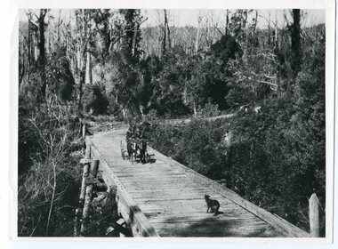
black and white photograph, 1913
This photograph is of the low level bridge across the Bemm River about 50 km east of Orbost in East Gippsland.This is a pictorial record of the 1913 low level bridge across the Bemm River, East Gippsland.A large black / white photograph of a horse - drawn wagon on the low level Bemm River bridge. In the foreground on the bridge is a dog.on back - "Country Roads Board Princes Highway low level bridge" -
 Orbost & District Historical Society
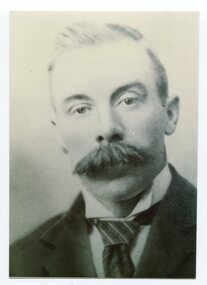
black and white photograph, C1926
This is a photograph of Councillor J. Walker who represented East Riding on the Orbost Shire council from 1915 - 1926.This item is associated with the Orbost Shire Council. The shire covered an area of 9,347 square kilometres and existed from 1892 until 1994 when it became part of the East Gippsland Shire Council.A black / white head and shoulders portrait photograph of a moustached man in a suit.on back - "Cr J. Walker, East Riding 1915-1926"walker-j. orbost-shire-council -
Lakes Entrance Historical Society
Book, Cox, Rev. George, Notes on Gippsland History Vol. 2. The Beginnings of Gippsland, 1990
An edited version of Rev. George Coxs Notes on Gippsland History which appeared in Gippsland Standard from 1911 to 1930, this volume dealing with the years 1840 to 1841periodicals -
 Orbost & District Historical Society
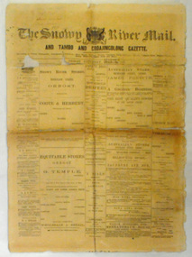
newspaper, Snowy River Mail, August 9 1890
Published as The Snowy River mail and Tambo and Croajingolong gazette from 1890 to 1911. The Gippsland Courier merged with the Snowy River Mail when proprietor Lachlan Ross moved to Orbost in 1910 In 1999 the paper was acquired by the Yeates family when the Hollins family retired from the newspapers business.The paper is still being produced by the fourth generation of the Yeates family as part of East Gippsland Newspapers. They also produce the Bairnsdale Advertiser, the East Gippsland News and the Lakes Post and the yearly publications East Gippsland Visitor Guide and the Great Alpine Road Touring Guide. This newspaper is still being produced today. Local newspapers play a vital role in communities as they are central to communication networks in regional areas of Australia. They are a valuable source of local news, act as a forum for debate and often set the agenda for local discussion. This item is a useful research tool as it reflects contemporary views.This newspaper is a first issue of 4 pp. It is titled "Snowy River Mail & Tambo and Croajingolong Gazette Orbost Saturday August 9 1890".snowy-mail-newspaper first-issue -
 Orbost & District Historical Society
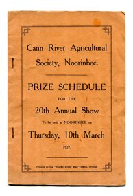
program, Snowy River Mail, 1927
Cann River is a town in the East Gippsland region of Victoria in Australia. The town is located on the Cann River at the junction of the Princess Highway and the Monaro Highway, in the Shire of East Gippsland. Before 1929 the original Cann River settlement was where Noorinbee now stands.Agricultural shows are an important part of cultural life in small country towns and these shows form an integral part of local history. This item reflects the significance of a volunteer group which no longer exists.A stapled paper program, orange with black print,"Cann River Agricultural Society, Noorinbee Prize Schedule for the 20th Annual Show to be held at Noorinbee on Thursday 10th March 1927" inside a rectangular black frame. -
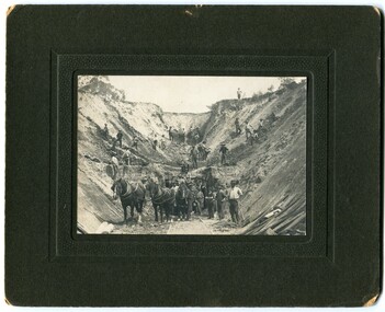 Orbost & District Historical Society
black and white photograph, early 20th century
There is no information with this photograph. It could be associated with the construction of the East Gippsland Railway.This is a pictorial record of construction work in the early 20th century. It shows the use of hand tools and horse and cart transport.A black / white photograph on a black buff card. It shows men working with picks and shovels to construct a pass. There is a horse and cart in the foreground.road-construction railway-construction civil-engineering -
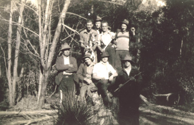 Lakes Entrance Historical Society
Photograph - The 4 Mile Camp Old Buchan Road, Buchan Victoria, 1935-36
Black and white photograph of eight bush workers Charles Pettman with a dog posed in a bush setting at the Four Mile Old Buchan Road East Gippsland Victoria. Names on second photoworkmen, engineering, government services -
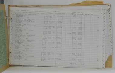 Orbost & District Historical Society
rate books, 1977 - 1984
These items were donated to Orbost & District Historical society from P.R.O.V. as a Place of Deposit (POD) item for safe keeping by a local history group or museum. The shire covered an area of 9,347 square kilometres and existed from 1892 until 1994 when it became part of the East Gippsland Shire Council. The East Gippsland Region Water Authority was constituted on January 1, 1995. The new Authority assumed responsibility for the services previously provided by the Mitchell Water Board, the Tambo Water Board, the Orbost Water Board and the Mallacoota Water Board. East Gippsland Water is the registered business name of the East Gippsland Region Water Authority. (info. from P.R.O.) These items are a historical record of Orbost Shire transactions with water management authorities which no longer exist.Seven rate books for the Shire of Orbost, Mallacoota and Cann River Water Trust. 2554.1 with records from 1977-1978 has a brown cardboard cover and string binding. 2554.2 has a brown cardboard cover with a hand-written title and green string binding. Records are from 1978 -1979. 2554.3 has a brown cardboard cover with a hand-written title and green string binding. Records are from 1919 - 1980. 2554.4 has a white cardboard cover and taped spine. In black print on the cover is 1980/1981. 2554.5 has a green cover with a metal fastening clip. Records are from 1980 -1981. 2554.6 has a white cover, taped binding and metal clips.Records are from 1982 -1983. 2554.7 has a white cover and metal rings. It is dated 1984.water-rates cann-valley-water-board -
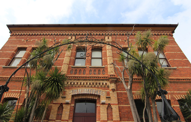 Victorian Interpretive Projects Inc.
Photograph - colour, Clare Kathleen Gervasoni, Former Ballarat East Library, 2015, 05/04/2015
Colour photographs of a brick building which is the former Ballarat East Library.ballarat east library, ballarat east high school, ballarat school of mines -
Federation University Historical Collection
Booklets, Gippsland Institute of Advanced Education External Studies, 1976-1984
Federation University Australia was established on 1 January 2014. Formerly known as the University of Ballarat, its enabling legislation was the University of Ballarat Amendment (Federation University Australia) Act 2013. Although formally created as a University in 1994, the University of Ballarat had a lineage back to 1870 with the establishment of the School of Mines Ballarat, making it the third institution of higher learning to be established in Australia and the first to be established in regional Australia. On 1 January 1994, Ballarat University College became the University of Ballarat and in 1998 the University merged with three TAFE Institutes to become a dual sector institution with multiple campuses. On 1 January 2014, the University of Ballarat amalgamated with the Monash University Gippsland Campus to form Federation University Australia. The Gippsland Campus also had a long lineage dating back to 1928 with the establishment of the Yallourn Technical School which became a predecessor institution to the Gippsland College of Advanced Education formed in 1968. In 1990, it was renamed the Monash University College and in 1993 became the Gippsland Campus of Monash University. Federation University Australia, or FedUni, is Australia’s newest public University. Headquartered in Ballarat, Victoria, the University offers programs in Higher Education and Vocational Education and Training to regional Victoria and beyond. The University’s commitment to educational and social equity, teaching excellence, research distinction, environmental sustainability and regional capacity building has enabled it to develop in a way that draws on its proud heritage to inform its future. Its regional character sets a framework for the University’s priorities but does not constrain it from serving wider community interests, nationally and internationally. With campuses from Horsham in the west of the state, to Churchill in the east, the name Federation University Australia was chosen to convey the scope and capacity of an expanded regional university with a federated network of campuses contributing to a new and different Australian university.5 booklets outlining external studies at the Gippsland Institute of Advanced Education. Staffmembers of particular courses are given. .1) 1976 (white) .2) 1977 (white) .3) 1982 (white) .4) 1983 (brown) .5) 1984 (blue)gippsland institute of advanced education, churchill, gippsland campus, keith hamilton, a. marianne robinson, andrea devent, peter harwood, alan maclaine, graham dettrich, leslie g. gordon, ethel ruymaker, kevin hince, william battersby, ann hodgkinson, eric thorne, john etheredge, v.g. venturini, rhonda jacobs, peter farago, asim kumar pal, martin hooper, jeffrey dowsley, neil clutterbuck, john yocklunn, janet martin, neil grant, michelle harris, felicetta kille, jennifer hill, john levans, clive vernon, peter charles -
 Orbost & District Historical Society
black and white photograph, first half 20th century
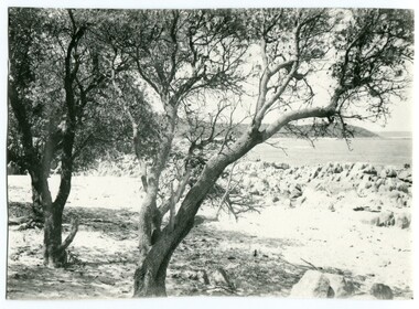
this photograph is of Cape Conran in Far East Gippsland. It appears to be a copy of a commercial postcard available to tourists or East Gippsland residents to send to friends or relatives.Cameras in the early 20th century were not a common family possession and a postcard was a common souvenir and way of sending a short message.Postcards form a vital part of social and historical records for researchers. A black / photograph of trees and a beach with rocks and the ocean in the background. It appears to be a copy of a postcard and has been hand trimmed.cape-conran -
 Ringwood and District Historical Society
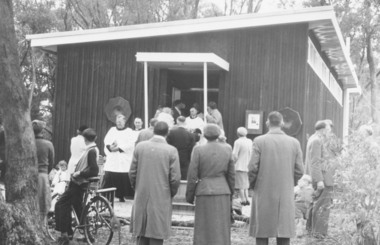
Photograph, Church of England, Patterson Street, East Ringwood, Vic. - circa 1960
Church of England Church at East Ringwood with people leavingWritten on back of photograph, "E. Rwd." Church of England Church at East Ringwood -
 Federation University Historical Collection
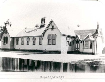
Photograph - Photograph - black and white, Ballarat East State School (No 1071)
The weatherboard Ballarat East State School SS 1071 was formerly known as Specimen Hill. According to 'Visions and Realisations' The Eureka gold lead opened in August 1852, running from Little Bendigo, south beneath Yarrowee Creek into Pennyweight flat, where it was joined 100 yards or so from the intersection of main and Eureka Streets by the Canadian Lead. State School 1071 was formerly known as Ballarat Common School No. 71, and was founded by the Free Presbyterian Church on Specimen Hill in Eureka Street, Ballarat on 01 January 1854. On 20 May 1869 the trustees of the Presbyterian School, Specimen Hill, Ballarat, consented to the transfer of the site to the Board of Education. On 01 September 1870, Specimen Hill, Ballarat, was vested in the Board and then became known as SS 1071. On 01 March 1879 the Minister, The Hon. William Collard Smith, and William Dobbie, Inspector of School Buildings, visited Ballarat to report on the buildings with a view to extensions and renovations. The minister issued instructions for the old wooden part of the school to be demolished, and brick additions to be erected, so that the whole premises would accommodate 350 students. (''Visions and Realisations: A Century of State Education in Victoria, Vol. 2'', Education Department of Victoria, 1973, p 729-730.)Black and white photograph of a weatherboard school with shingle roof known as Ballarat East (SS1071). The building has a brick chimney and bell tower. This school has Castlemaine flagging in the passages.ballarat east state school, education, st paul's school, specimen hill state school -
 Ballarat Heritage Services
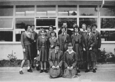
Photograph - Black and White, Ballarat East High School Form Photo 1959, 1959
Black and white photograph of a group of girls from Ballarat East High School.ballarat east high school, education, ballarat east -
 Ballarat Heritage Services
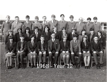
Photograph - Black and White, Ballarat East High School, Form 6, 1968, 1968
Black and white Ballarat East High School Form 6 class photograph.ballarat east high school, education -
 Ballarat Heritage Services
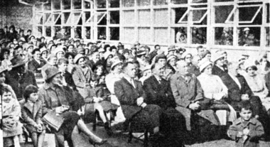
Newspaper clipping, Ballarat East High School, Crowd at Opening of the School
Newspaper clipping showing a photograph of the audience at the opening of Ballarat East High School.ballarat east high school, education, ballarat east -
 Ballarat Heritage Services
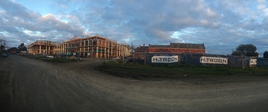
Development Near Mercy Convent, Ballarat East, 2017, 08/2017
Colour photograph of a Development in Ballarat East. It is a retirement village run by the Mercy sisters. ballarat, mercy convent, ballarat east, retirement home -
![Harp Junction [Kew East]](/media/collectors/550653872162f11fb04854aa/items/58cf094bd0ce9809d8715cf3/item-media/58cf59d0d0ce5d331467358d/item-fit-380x285.jpg) Kew Historical Society Inc
Kew Historical Society IncPhotograph, Harp Junction [Kew East], 1910-1930
Kew Junction at this stage was a tram terminusThe Harp Junction, East Kew.Annotation on reverse: "East Kew - looking towards city from harp of Erin Hotel - note wooden fence."harp of erin hotel (kew), high street (kew) -
 Kew Historical Society Inc
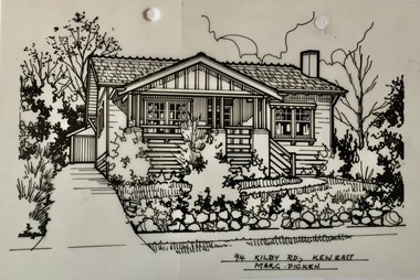
Drawing - Property Illustration, Margaret Picken, 94 Kilby Road, Kew East, 1983-2006
After training as a Cartographic Draftsman within the mining industry, I worked as a property illustrator for real estate firms in the eastern suburbs of Melbourne for 23 years from 1983. I initially photographed houses with a Polaroid camera and made a 'thumbnail' sketch while there. The photos were used to scale off a sketch in pencil and then that sketch was overlaid with drafting film and the 'pen and ink' completed. The pens I used were the Rotring ‘Rapidigraph’ drafting pens. The ink was also made by Rotring (German).The film was ‘Rapidraw’, polyester drafting film, double matte. It takes a very fine line and doesn’t bleed. As well as house sketches, there were often floor plans and site plans ordered. Aerial sketches were ordered when the property needed an overall view. (Margaret Picken, 2020)This drawing is one of a series created by Margaret Picken for real estate agents in Melbourne between 1983 and 2006. Each work is signed and dated by the artist.Gift of Margaret Picken, 2020Pen and ink drawing on drafting film of 94 Kilby Road, Kew East by Margaret Picken.94 KILBY RD., KEW EAST / MARG. PICKEN artist -- margaret picken 1950-, property illustrations — buildings — kew east (vic.), 94 kilby road - kew east (vic) -
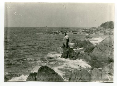 Orbost & District Historical Society
black and white photograph, first half 20th century
This is a photograph of a man fishing off the rocks at Cape Conran in Far East Gippsland.Cape Conran has always been a popular fishing destination for Orbost people. This photograph is a pictorial record of that recreational activity in the early 20th century. A black / white photograph of a man fishing from rocks into the ocean. -
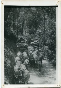 Orbost & District Historical Society
black and white photograph, late 19th - early 20th century
This is a photograph of bullock teams on the Cann Road. out of Cann River, East Gippsland.This is a pictorial record of transport in the mid 18th - early 19th century. Bullock teams could travel in country inaccessible to larger horse - drawn carts or wagon.A black / white photograph of two bullock teams travelling side by side along a bush road.transport-bullocks cann-river -
National Vietnam Veterans Museum (NVVM)
Audio - Audio, CD, Radio interview of Krishna Methven, Jo Parker, Gary Parker & Bill Noble
Interview done by West Gippsland Community Radio, February 2007national vietnam veterans museum -
 Ringwood and District Historical Society
Photograph-B&W, Joan Walker, East Ringwood 2000-Warrawong Kindergarten, 2000
East Ringwood 2000-Warrawong Kindergarten- B&W Photo from Album 6501