Showing 64624 items matching "church-of-england"
-
 Warrnambool and District Historical Society Inc.
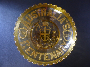
Plates x 4, Henry Greener and Company of Sunderland England, Souvenirs of Australian Centenary 1788-1888, 1888
... Souvenirs of Australian Centenary 1788-1888...Henry Greener and Company of Sunderland England ...These plates were pressed to commemorate the centenary of the European settlement of Australia. A large number were produced and the were distributed throughout AustraliaThese plates are a good example of souvenirs which were produced to commemorate the celebrations of the centenary of European settlement of Australia. The pressed glass was a common method of manufacturing around that period and of which they are an excellent example.001423.1 Large rounded amber glass dish with scalloped edge and seven fine rings below. Text is stippled glass on the back which appears through to the inside of the dish.An early version of Australian Coat of Arms is in the centre with the centenary years inside shields, either side. 001423.2 A smaller version of 001423.1 001423.3 Small clear glass saucer shaped dish with same design as the larger dishes. 001423.4 Small amber coloured shallow dish with small glass handle on each side. Pattern matching the larger plates is embossed on underside of the dish. The surface is scored acroos the centre bottom of the dish.Australia's Centenary in stippled glass around the edge of each dish. Advance Australia below the the Coat of Arms. 1788 1888. R*No 88120 behind one scallop on edge on each platewarrnambool, centenary of australia, centenary plates, 1788-1888 -
 Lakes Entrance Historical Society
Book, Rev Albert E Clark, Church of our Fathers, 1947
... Church of our Fathers ...A history of the Church of England in Gippsland from 1847 to 1947, the parishes and priests. This book also gives an insight into the early settlers of Gippsland, the growth of communities, and the hardships of families living in isolation. Illustrated wireligion -
 Linton and District Historical Society Inc
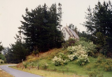
Photograph, St Paul's Church, Linton, 1980, 1980
Colour photo of church building set on hill among trees."St Paul's Church".st paul's anglican church linton -
Ringwood and District Historical Society
Postcard, Photochrom Co. Ltd, Photochrom' fold-out lettercard of Ringwood, England c1930
... Photochrom' fold-out lettercard of Ringwood, England c1930 ...'Photochrom' fold-out lettercard of Ringwood, England, from R.J.H. Futcher, Geelong. Contains 6 black and white photographs c.1930. -
 Ringwood RSL Sub-Branch
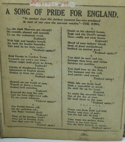
Document, A song for pride of England
... A song for pride of England ...Paper page with the words to the song.Words to the song "A song for the pride of England". -
 Ballarat Heritage Services
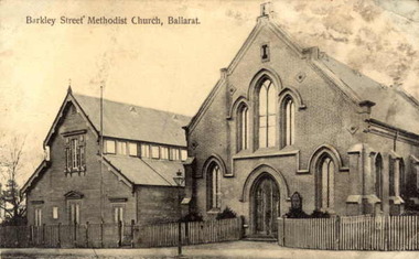
Photograph, Barkly Street Uniting Church
Postcard showing Ballarat's Barkly Street Methodist Church, later known as Barkly Street Uniting Church.A plaque reads "This plaque is in memory of the pioneers of this community and the Methodist Church est circa 1853 in a canvas tent. This brick building was built in 1859 with collections from the congregation. First Minister of the church was the Reverend Theopholis Taylor 1829 ~ 1858 -and the Methodist Church in 1977 became part of the Uniting Church in Australia.barkly street uniting church, barkly street methodist church, religion, theopholis taylor -
 Greensborough Historical Society
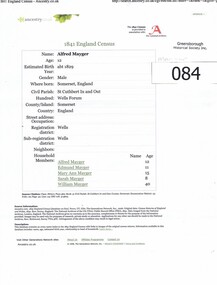
Administrative record - Census, Alfred Mayger: 1841 England Census, 1841_
Background to the Mayger family in EnglandMayger family were a pioneer family in the Greensborough area3 x A4 pages. Citation from the 1841 England Census for Alfred Mayger, accessed via Ancestry.co. Also pages from National Burial Index detailing Mayger burials in Somerset.mayger family, alfred mayger -
 Whitehorse Historical Society Inc.
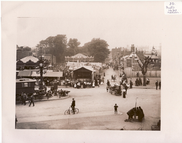
Photograph, Mitcham, England, 1900
Black and white photo of Black and white photo of Mitcham Fair on Fair Green by Thos. Francis, London House, Mitcham, England. 1900. The photo overlaps and give a panorama of the Fair as far as could been seen from Ravensbury House (J.D.Drewett). See NP1437mitcham, surrey, england -
 Greensborough Historical Society
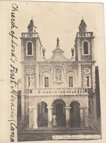
Photograph - Digital image, Charles Marshall et al, Church of the Lord's first miracle, Cana, 1917_
... Church of the Lord's first miracle, Cana. ...This photographs depicts the Church of the Lord's first miracle at Cana [turning water into wine at the marriage feast].Digital copy of black and white photograph. Caption written on front "Church of Lord's first miracle, Cana"charles marshall, world war 1 -
 Ballarat Heritage Services
Photograph - Digital photograph, Gong Gong Methodist Church
Families in the vicinity includes the O'Dea, Kinnane, Quin and Nestor families. Image of a weatherboard Church at Gong Gong near Ballarat.Gong Gong Methodist Churchkinnane, quin, nestor, yarrowee soap works, gong gong, gong gong methodist church -
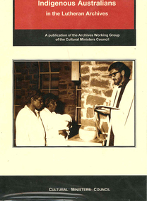 Victorian Aboriginal Corporation for Languages
Book, Lutheran Church of Australia, A guide to records of Indigenous Australians in the Lutheran Archives, Adelaide, SA, 1999
... A guide to records of Indigenous Australians in the...Lutheran Church of Australia ...A valuable resource in assisting Indigenous Australians to locate information from records, from 10 Lutheran Missions in SA, NT, Qld, held in Adelaide.tableslutheran church, lutheran archives, south australia, genealogy, northern territory, queensland -
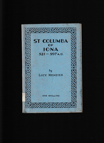 Mrs Aeneas Gunn Memorial Library
Book, Church of Scotland, St Columb of Iona 521-597, 1935
... St Columb of Iona 521-597...Church of Scotland ...A history of St Columba and the Iona monasteryp.84.non-fictionA history of St Columba and the Iona monasterychristain hagiography, christain saints -
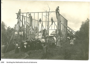 Mt Dandenong & District Historical Society Inc.
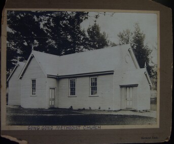
Photograph, Building the Methodist Church at Kalorama, 1909
The Methodist Church was built in 1910 by volunteer labour. Mainly through the efforts of the daughters of Eliza Hand and their families - the Jeeves, Walkers and Badenhops. (Lundy-Clarke manuscript)Local residents working to erect the frame of the Methodist Church on the Main Road (Ridge Road) at Kalorama. Eight workmen are on the frame with fifteen well dressed residents standing in front. 1910. Image received as a digital jpeg.Printed on front of photo: 1909 Building the Methodist Church at Kalorama church, kalorama methodist church, methodist church -
![Book, Kangaroo Ground Presbyterian Church : early history / [compiled by Vera Jackson and Joy Ness], 1978](/media/collectors/4f729f7b97f83e03086018a5/items/59279355d0cdd112c0f0b581/item-media/5bac2fa821eadb156899cb53/item-fit-380x285.jpg) Eltham District Historical Society Inc
Eltham District Historical Society IncBook, Kangaroo Ground Presbyterian Church : early history / [compiled by Vera Jackson and Joy Ness], 1978
Paperback; 11p. ; 20cm.ISBN 0909503419kangaroo ground, churches, kangaroo ground presbyterian church -
 Stawell Historical Society Inc
Book, Baptist Church, The Church - 14 Volumes Magazines 1874-79, 1874-1900
stawell religion -
Koorie Heritage Trust
Booklet, Blake, Thom et al, The Uniting Church and Aborigines, 1984
Gives the Uniting Church's position on many questions posed by other rces on Aboriginals. «xplains clearly some of the misconceptions on rights and reconciliation.33 P.Gives the Uniting Church's position on many questions posed by other rces on Aboriginals. «xplains clearly some of the misconceptions on rights and reconciliation.uniting church in australia. | aboriginal australians -- religion. | aboriginal australians -- civil rights. -
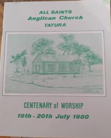 Tatura Irrigation & Wartime Camps Museum
Programme - Booklet, All Saints Anglican Church Tatura Centenary of Worship, 1980
... All Saints Anglican Church Tatura Centenary of Worship ...A programme written by the Church to celebrate the Centenary of Worship on the 18 - 20 July 1980.Pale green soft covered programme with green print and green drawing of church.all saints anglican church tatura, centenary of worship 1980, church -
Kew Historical Society Inc
Book, Keith Cole, Letters from China 1893-1895: the story of the sister martyrs of Ku Cheng, 1988
... Letters from China 1893-1895: the story of the sister ...Kew, Vic. : St. Hilary's Anglican Church, 1988 x, 136 p. : ill., map, ports. ; 21 cm. non-fictioneleanor saunders 1871-1895, elizabeth saunders 1873-1895, st hilary's anglican church -- kew -- (vic.), missionaries -- china -- biography -
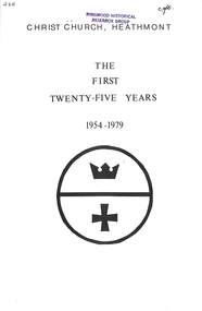 Ringwood and District Historical Society
Book, Verna M. Adams, Christ Church Heathmont - The First Twenty-Five Years, 1954-1979, 1980
Short history of Church of England's Christ Church, Canterbury Road, Heathmont - 25th Anniversary 1954-1979, by Verna M. AdamsVerna M. Adams: "I would like to acknowledge the help I have received from many quarters, and to express my appreciation of their unstinting labours on behalf of this volume. Photography: Kendrick Pereira Typing: Gladys Perkins, Betty Growse and all who lent photographic material and records." -
 Warrnambool and District Historical Society Inc.
Document, Grasmere Church Dispute, 1882
These papers contain cuttings newspaper articles from the Standard of 1882 and handwritten comments appended to these cuttings. They refer to a dispute in 1882 regarding the ownership of the church in Grasmere to which the Anglican Church was claiming ownership The author of the handwritten comments is unknown but the comments purport to be a more accurate account of events than what appears in the paper cuttings. Grasmere is a small settlement 10 kilometres north of Warrnambool. In the 1850s land in Grasmere was donated for educational purposes and a Government-subsidized school which was a Denominational School run by the Church of England was established in 1858. This school was closed when Government State Schools were established after 1872 and the Anglican Church dismantled the old school and built a church on the site in the late 1870s. This church was erected by public subscription and many of the subscribers apparently believed they were donating to a building that could be used by any local Protestant churchgoers. The church in 1882 was being used by the Presbyterian Church for its services. A public meeting was held in 1882 to try to resolve the dispute between the Anglican Church claim and the local residents’ claim that the site belonged to the local community. Apparently the dispute remained unresolved and the Grasmere Anglican Church continued to operate until the early 20th century. This document is of interest as it is associated with a dispute that took place in Grasmere in 1882 and gives some indication of the arguments that were presented at the time in favour of, or opposed to, the Anglican Church’s claim to the ownership of the church. It is a document of particular interest to the history of the Grasmere. This is a folder of eleven foolscap-size sheets of paper enclosed in a mottle-coloured cardboard cover. The front cover is creased and partly torn and the back cover is detached and is in two pieces. The pages have been stitched together with thread and contain paste-in newspaper cuttings and handwritten material in purple ink. Grasmere Anglican Church -
Federation University Historical Collection
Document, Cuthbert and Wynne, Conditions and Particulars of Sale for the former Ballarat Wesley Church, 1883, 20/12/1883
... Conditions and Particulars of Sale for the former Ballarat ...The former Ballarat Wesley Church was used as the Ballarat School of Mines Museum.Copy of a contract concerning the sale of the former Ballarat Wesley Church to the Ballarat School of Mines ballarat school of mines museum., ballarat wesley church, ballarat methodist church, legal, cuthbert and wynne, james oddie, andrew berry, whiteside -
 Mt Dandenong & District Historical Society Inc.
Photograph, Congregation of Kalorama Methodist Church 1911
... Congregation of Kalorama Methodist Church 1911. ...Congregation gathered for photograph at front of Kalorama Methodist Church at FiveWays. The area was known as Mt Dandenong North until 1926 when the name was changed to Kalorama. The people assembled are all members of the local community. The church was built by the community in 1910.Black and white photograph showing a group of 31 people gathered in front of a wooden church building.kalorama, methodist church -
 Flagstaff Hill Maritime Museum and Village
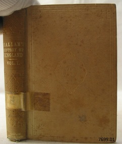
Book, The Constitutional History of England Vol 1
... The Constitutional History of England Vol 1 ...This item is from the ‘Pattison Collection’, a collection of books and records that was originally owned by the Warrnambool Mechanics’ Institute, which was founded in Warrnambool in 1853. By 1886 the Warrnambool Mechanics’ Institute (WMI) had grown to have a Library, Museum and Fine Arts Gallery, with a collection of “… choice productions of art, and valuable specimens in almost every branch and many wonderful national curiosities are now to be seen there, including historic relics of the town and district.” It later included a School of Design. Although it was very well patronised, the lack of financial support led the WMI in 1911 to ask the City Council to take it over. In 1935 Ralph Pattison was appointed as City Librarian to establish and organise the Warrnambool Library as it was then called. When the WMI building was pulled down in 1963 a new civic building was erected on the site and the new Warrnambool Library, on behalf of the City Council, took over all the holdings of the WMI. At this time some of the items were separated and identified as the ‘Pattison Collection’, named after Ralph Pattison. Eventually the components of the WMI were distributed from the Warrnambool Library to various places, including the Art Gallery, Historical Society and Flagstaff Hill. Later some were even distributed to other regional branches of Corangamite Regional Library and passed to and fro. It is difficult now to trace just where all of the items have ended up. The books at Flagstaff Hill Maritime Village generally display stamps and markings from Pattison as well as a variety of other institutions including the Mechanics’ Institute itself. RALPH ERIC PATTISON Ralph Eric Pattison was born in Rockhampton, Queensland, in 1891. He married Maude Swan from Warrnambool in 1920 and they set up home in Warrnambool. In 1935 Pattison accepted a position as City Librarian for the Warrnambool City Council. His huge challenge was to make a functional library within two rooms of the Mechanics’ Institute. He tirelessly cleaned, cleared and sorted a disarrayed collection of old books, jars of preserved specimens and other items reserved for exhibition in the city’s museum. He developed and updated the library with a wide variety of books for all tastes, including reference books for students; a difficult task to fulfil during the years following the Depression. He converted all of the lower area of the building into a library, reference room and reading room for members and the public. The books were sorted and stored using a cataloguing and card index system that he had developed himself. He also prepared the upper floor of the building and established the Art Gallery and later the Museum, a place to exhibit the many old relics that had been stored for years for this purpose. One of the treasures he found was a beautiful ancient clock, which he repaired, restored and enjoyed using in his office during the years of his service there. Ralph Pattison was described as “a meticulous gentleman whose punctuality, floorless courtesy and distinctive neat dress were hallmarks of his character, and ‘his’ clock controlled his daily routine, and his opening and closing of the library’s large heavy doors to the minute.” Pattison took leave during 1942 to 1945 to serve in the Royal Australian Navy, Volunteer Reserve as Lieutenant. A few years later he converted one of the Museum’s rooms into a Children’s Library, stocking it with suitable books for the younger generation. This was an instant success. In the 1950’s he had the honour of being appointed to the Victorian Library Board and received more inspiration from the monthly conferences in Melbourne. He was sadly retired in 1959 after over 23 years of service, due to the fact that he had gone over the working age of council officers. However he continued to take a very keen interest in the continual development of the Library until his death in 1969. The Pattison Collection, along with other items at Flagstaff Hill Maritime Village, was originally part of the Warrnambool Mechanics' Institute’s collection. The Warrnambool Mechanics’ Institute Collection is primarily significant in its totality, rather than for the individual objects it contains. Its contents are highly representative of the development of Mechanics' Institute libraries across Australia, particularly Victoria. A diversity of publications and themes has been amassed, and these provide clues to our understanding of the nature of and changes in the reading habits of Victorians from the 1850s to the middle of the 20th century. The collection also highlights the Warrnambool community’s commitment to the Mechanics’ Institute, reading, literacy and learning in the regions, and proves that access to knowledge was not impeded by distance. These items help to provide a more complete picture of our community’s ideals and aspirations. The Warrnambool Mechanics Institute book collection has historical and social significance for its strong association with the Mechanics Institute movement and the important role it played in the intellectual, cultural and social development of people throughout the latter part of the nineteenth century and the early twentieth century. The collection of books is a rare example of an early lending library and its significance is enhanced by the survival of an original collection of many volumes. The Warrnambool Mechanics' Institute’s publication collection is of both local and state significance. The Constitutional History of England Vol 1 From the Accession of Henry Vll to the Death of George ll Author: Henry Hallam Publisher: John Murray Date: 1866Label on spine cover with typed text PAT 942 HAL Pastedown front endpaper has sticker from Warrnambool Mechanics Institute and Free Library Front loose endpaper has a sticker from Corangamite Regional Library Service warrnambool, shipwrecked-coast, flagstaff-hill, flagstaff-hill-maritime-museum, maritime-museum, shipwreck-coast, flagstaff-hill-maritime-village, shipwrecked-artefact, book, pattison collection, warrnambool library, warrnambool mechanics’ institute, ralph eric pattison, corangamite regional library service, warrnambool city librarian, mechanics’ institute library, victorian library board, warrnambool books and records, warrnambool children’s library, great ocean road, the constitutional history of england vol 1, henry hallam -
 Flagstaff Hill Maritime Museum and Village
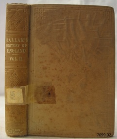
Book, The Constitutional History of England Vol 2
... The Constitutional History of England Vol 2 ...This item is from the ‘Pattison Collection’, a collection of books and records that was originally owned by the Warrnambool Mechanics’ Institute, which was founded in Warrnambool in 1853. By 1886 the Warrnambool Mechanics’ Institute (WMI) had grown to have a Library, Museum and Fine Arts Gallery, with a collection of “… choice productions of art, and valuable specimens in almost every branch and many wonderful national curiosities are now to be seen there, including historic relics of the town and district.” It later included a School of Design. Although it was very well patronised, the lack of financial support led the WMI in 1911 to ask the City Council to take it over. In 1935 Ralph Pattison was appointed as City Librarian to establish and organise the Warrnambool Library as it was then called. When the WMI building was pulled down in 1963 a new civic building was erected on the site and the new Warrnambool Library, on behalf of the City Council, took over all the holdings of the WMI. At this time some of the items were separated and identified as the ‘Pattison Collection’, named after Ralph Pattison. Eventually the components of the WMI were distributed from the Warrnambool Library to various places, including the Art Gallery, Historical Society and Flagstaff Hill. Later some were even distributed to other regional branches of Corangamite Regional Library and passed to and fro. It is difficult now to trace just where all of the items have ended up. The books at Flagstaff Hill Maritime Village generally display stamps and markings from Pattison as well as a variety of other institutions including the Mechanics’ Institute itself. RALPH ERIC PATTISON Ralph Eric Pattison was born in Rockhampton, Queensland, in 1891. He married Maude Swan from Warrnambool in 1920 and they set up home in Warrnambool. In 1935 Pattison accepted a position as City Librarian for the Warrnambool City Council. His huge challenge was to make a functional library within two rooms of the Mechanics’ Institute. He tirelessly cleaned, cleared and sorted a disarrayed collection of old books, jars of preserved specimens and other items reserved for exhibition in the city’s museum. He developed and updated the library with a wide variety of books for all tastes, including reference books for students; a difficult task to fulfil during the years following the Depression. He converted all of the lower area of the building into a library, reference room and reading room for members and the public. The books were sorted and stored using a cataloguing and card index system that he had developed himself. He also prepared the upper floor of the building and established the Art Gallery and later the Museum, a place to exhibit the many old relics that had been stored for years for this purpose. One of the treasures he found was a beautiful ancient clock, which he repaired, restored and enjoyed using in his office during the years of his service there. Ralph Pattison was described as “a meticulous gentleman whose punctuality, floorless courtesy and distinctive neat dress were hallmarks of his character, and ‘his’ clock controlled his daily routine, and his opening and closing of the library’s large heavy doors to the minute.” Pattison took leave during 1942 to 1945 to serve in the Royal Australian Navy, Volunteer Reserve as Lieutenant. A few years later he converted one of the Museum’s rooms into a Children’s Library, stocking it with suitable books for the younger generation. This was an instant success. In the 1950’s he had the honour of being appointed to the Victorian Library Board and received more inspiration from the monthly conferences in Melbourne. He was sadly retired in 1959 after over 23 years of service, due to the fact that he had gone over the working age of council officers. However he continued to take a very keen interest in the continual development of the Library until his death in 1969. The Pattison Collection, along with other items at Flagstaff Hill Maritime Village, was originally part of the Warrnambool Mechanics' Institute’s collection. The Warrnambool Mechanics’ Institute Collection is primarily significant in its totality, rather than for the individual objects it contains. Its contents are highly representative of the development of Mechanics' Institute libraries across Australia, particularly Victoria. A diversity of publications and themes has been amassed, and these provide clues to our understanding of the nature of and changes in the reading habits of Victorians from the 1850s to the middle of the 20th century. The collection also highlights the Warrnambool community’s commitment to the Mechanics’ Institute, reading, literacy and learning in the regions, and proves that access to knowledge was not impeded by distance. These items help to provide a more complete picture of our community’s ideals and aspirations. The Warrnambool Mechanics Institute book collection has historical and social significance for its strong association with the Mechanics Institute movement and the important role it played in the intellectual, cultural and social development of people throughout the latter part of the nineteenth century and the early twentieth century. The collection of books is a rare example of an early lending library and its significance is enhanced by the survival of an original collection of many volumes. The Warrnambool Mechanics' Institute’s publication collection is of both local and state significance. The Constitutional History of England Vol 2 From the Accession of Henry Vll to the Death of George ll Author: Henry Hallam Publisher: John Murray Date: 1866Label on spine cover with typed text PAT 942 HAL Pastedown front endpaper has sticker from Warrnambool Mechanics Institute and Free Library Front loose endpaper has a sticker from Corangamite Regional Library Service warrnambool, shipwrecked-coast, flagstaff-hill, flagstaff-hill-maritime-museum, maritime-museum, shipwreck-coast, flagstaff-hill-maritime-village, shipwrecked-artefact, book, pattison collection, warrnambool library, warrnambool mechanics’ institute, ralph eric pattison, corangamite regional library service, warrnambool city librarian, mechanics’ institute library, victorian library board, warrnambool books and records, warrnambool children’s library, great ocean road, the constitutional history of england vol 2, henry hallam -
 Flagstaff Hill Maritime Museum and Village
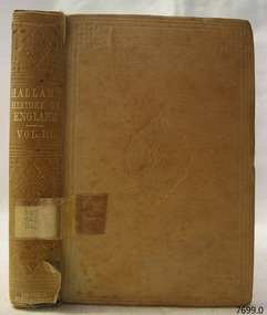
Book, The Constitutional History of England Vol 3
... The Constitutional History of England Vol 3 ...This item is from the ‘Pattison Collection’, a collection of books and records that was originally owned by the Warrnambool Mechanics’ Institute, which was founded in Warrnambool in 1853. By 1886 the Warrnambool Mechanics’ Institute (WMI) had grown to have a Library, Museum and Fine Arts Gallery, with a collection of “… choice productions of art, and valuable specimens in almost every branch and many wonderful national curiosities are now to be seen there, including historic relics of the town and district.” It later included a School of Design. Although it was very well patronised, the lack of financial support led the WMI in 1911 to ask the City Council to take it over. In 1935 Ralph Pattison was appointed as City Librarian to establish and organise the Warrnambool Library as it was then called. When the WMI building was pulled down in 1963 a new civic building was erected on the site and the new Warrnambool Library, on behalf of the City Council, took over all the holdings of the WMI. At this time some of the items were separated and identified as the ‘Pattison Collection’, named after Ralph Pattison. Eventually the components of the WMI were distributed from the Warrnambool Library to various places, including the Art Gallery, Historical Society and Flagstaff Hill. Later some were even distributed to other regional branches of Corangamite Regional Library and passed to and fro. It is difficult now to trace just where all of the items have ended up. The books at Flagstaff Hill Maritime Village generally display stamps and markings from Pattison as well as a variety of other institutions including the Mechanics’ Institute itself. RALPH ERIC PATTISON Ralph Eric Pattison was born in Rockhampton, Queensland, in 1891. He married Maude Swan from Warrnambool in 1920 and they set up home in Warrnambool. In 1935 Pattison accepted a position as City Librarian for the Warrnambool City Council. His huge challenge was to make a functional library within two rooms of the Mechanics’ Institute. He tirelessly cleaned, cleared and sorted a disarrayed collection of old books, jars of preserved specimens and other items reserved for exhibition in the city’s museum. He developed and updated the library with a wide variety of books for all tastes, including reference books for students; a difficult task to fulfil during the years following the Depression. He converted all of the lower area of the building into a library, reference room and reading room for members and the public. The books were sorted and stored using a cataloguing and card index system that he had developed himself. He also prepared the upper floor of the building and established the Art Gallery and later the Museum, a place to exhibit the many old relics that had been stored for years for this purpose. One of the treasures he found was a beautiful ancient clock, which he repaired, restored and enjoyed using in his office during the years of his service there. Ralph Pattison was described as “a meticulous gentleman whose punctuality, floorless courtesy and distinctive neat dress were hallmarks of his character, and ‘his’ clock controlled his daily routine, and his opening and closing of the library’s large heavy doors to the minute.” Pattison took leave during 1942 to 1945 to serve in the Royal Australian Navy, Volunteer Reserve as Lieutenant. A few years later he converted one of the Museum’s rooms into a Children’s Library, stocking it with suitable books for the younger generation. This was an instant success. In the 1950’s he had the honour of being appointed to the Victorian Library Board and received more inspiration from the monthly conferences in Melbourne. He was sadly retired in 1959 after over 23 years of service, due to the fact that he had gone over the working age of council officers. However he continued to take a very keen interest in the continual development of the Library until his death in 1969. The Pattison Collection, along with other items at Flagstaff Hill Maritime Village, was originally part of the Warrnambool Mechanics' Institute’s collection. The Warrnambool Mechanics’ Institute Collection is primarily significant in its totality, rather than for the individual objects it contains. Its contents are highly representative of the development of Mechanics' Institute libraries across Australia, particularly Victoria. A diversity of publications and themes has been amassed, and these provide clues to our understanding of the nature of and changes in the reading habits of Victorians from the 1850s to the middle of the 20th century. The collection also highlights the Warrnambool community’s commitment to the Mechanics’ Institute, reading, literacy and learning in the regions, and proves that access to knowledge was not impeded by distance. These items help to provide a more complete picture of our community’s ideals and aspirations. The Warrnambool Mechanics Institute book collection has historical and social significance for its strong association with the Mechanics Institute movement and the important role it played in the intellectual, cultural and social development of people throughout the latter part of the nineteenth century and the early twentieth century. The collection of books is a rare example of an early lending library and its significance is enhanced by the survival of an original collection of many volumes. The Warrnambool Mechanics' Institute’s publication collection is of both local and state significance. The Constitutional History of England Vol 3 From the Accession of Henry Vll to the Death of George ll Author: Henry Hallam Publisher: John Murray Date: 1866Label on spine cover with typed text PAT 942 HAL Pastedown front endpaper has sticker from Warrnambool Mechanics Institute and Free Library Front loose endpaper has a sticker from Corangamite Regional Library Service warrnambool, shipwrecked-coast, flagstaff-hill, flagstaff-hill-maritime-museum, maritime-museum, shipwreck-coast, flagstaff-hill-maritime-village, shipwrecked-artefact, book, pattison collection, warrnambool library, warrnambool mechanics’ institute, ralph eric pattison, corangamite regional library service, warrnambool city librarian, mechanics’ institute library, victorian library board, warrnambool books and records, warrnambool children’s library, great ocean road, the constitutional history of england vol 3, henry hallam -
 Ringwood and District Historical Society
Photograph, The Methodist Church in Heathmont in 1967, 1967
The Methodist Church in Heathmont in 1967Written on back of photograph, "Methodist Church, Heathmont - 12.8.67". -
Whitehorse Historical Society Inc.
Magazine - Article, St John's Anglican Church, Blackburn, n.d
Article in church magazine mentioning the arrival of R.D.H. Ling, a 'little brother' from England.st johns anglican church, blackburn, ling, r.d.h. -
 Kew Historical Society Inc
Photograph, J E & B L Rogers, Methodist Church, Highbury Grove, c.1970
This work forms part of the collection assembled by the historian Dorothy Rogers, that was donated to the Kew Historical Society by her son John Rogers in 2015. The manuscripts, photographs, maps, and documents were sourced by her from both family and local collections or produced as references for her print publications. Many were directly used by Rogers in writing ‘Lovely Old Homes of Kew’ (1961) and 'A History of Kew' (1973), or the numerous articles on local history that she produced for suburban newspapers. Most of the photographs in the collection include detailed annotations in her hand.The Rogers Collection provides a comprehensive insight into the working habits of a historian in the 1960s and 1970s. Together it forms the largest privately-donated collection within the archives of the Kew Historical Society.Small, black and white photo of the Methodist Church in Highbury Grove, Kew."Methodist Church / Jim's / 40"churches -- kew (vic.), methodist church -- highbury grove -- kew (vic.) -
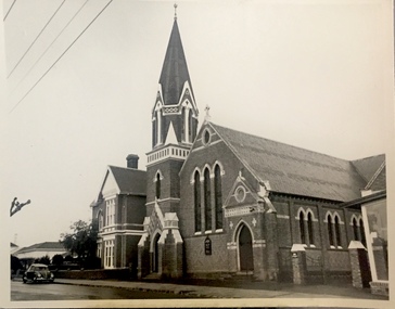
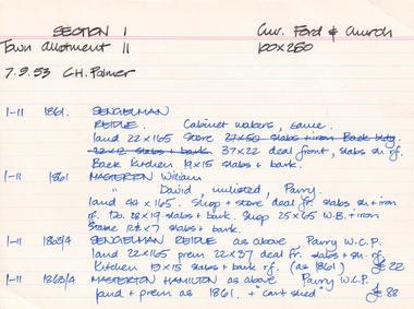 The Beechworth Burke Museum Research Collection
Card (Series) - Index Card, George Tibbits, Corner of Ford and Church Streets, Beechworth, 1976
... Corner of Ford and Church Streets, Beechworth...Faculty of Architecture, Building and Town & Regional ...George Tibbits, University of Melbourne. Faculty of Architecture, Building and Town & Regional PlanningIndex system that support the research for Beechworth : historical reconstruction / [by] George Tibbits ... [et al]Arranged by street names of BeechworthEach index card includes: street name and number of property, image of property, allotment and section number, property owners and dates of ownership, description of the property according to rate records, property floor plan with dimensions.beechworth, george tibbitsbeechworth, george tibbits -
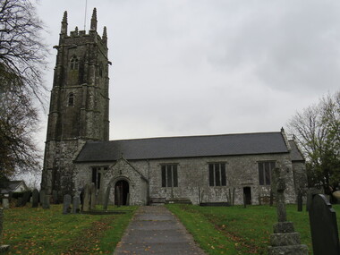 Ballarat Heritage Services
Photograph - Colour, Alwington Church, Devon, England