Showing 474 items
matching civic planning
-
 Kew Historical Society Inc
Photograph - Flooding of the Yarra Valley at Kew East, 1974
Flooding of the Yarra Valley, including that section of the Yarra bordering Kew and Kew East in the north and west of the municipality, was a regular occurrence. Extreme flood events of the Yarra River are recorded to have occurred in 1891, 1901, 1916, 1923 and 1934. The Municipality of Kew's response to these floods was to enact planning decisions restricting residential development in flood prone areas following the floods of 1916, 1921 and 1934. While floods continued after the development of the Upper Yarra Reservoir (construction 1948-57), the regularity and extent of these inundations diminished. During the nineteenth century, the land abutting the south side of the Yarra in Kew was devoted to dairy farming. In the twentieth century, before and after the construction of the Eastern Freeway, much of this low-lying area was used as golf courses and public parks.Late example of the capacity of the Yarra Valley at Kew to flood, even though drainage works and the Upper Yarra Reservoir had reduced their regularity.Original black and white print photograph of the low-lying land at East Kew under floodwater on 16 May 1974. The vantage point of the photographer is at Willsmere Road. The road itself is underwater.Annotation verso: "Willsmere Rd / Same as No.7 / 16 May 1974 11.15am"floods, yarra river, willsmere road -
 Kew Historical Society Inc
Photograph - Flooding of the Yarra Valley at Kew East, 1974
Flooding of the Yarra Valley, including that section of the Yarra bordering Kew and Kew East in the north and west of the municipality, was a regular occurrence. Extreme flood events of the Yarra River are recorded to have occurred in 1891, 1901, 1916, 1923 and 1934. The Municipality of Kew's response to these floods was to enact planning decisions restricting residential development in flood prone areas following the floods of 1916, 1921 and 1934. While floods continued after the development of the Upper Yarra Reservoir (construction 1948-57), the regularity and extent of these inundations diminished. During the nineteenth century, the land abutting the south side of the Yarra in Kew was devoted to dairy farming. In the twentieth century, before and after the construction of the Eastern Freeway, much of this low-lying area was used as golf courses and public parks.Late example of the capacity of the Yarra Valley at Kew to flood, even though drainage works and the Upper Yarra Reservoir had reduced their regularity.Original black and white print photograph of the low-lying land at East Kew under floodwater on 16 May 1974. The photograph is of Hyde Park looking north-east.Annotation verso: "Hyde Park looking nth-east / Flood Level / 16 May 1974 11.15am / R.L. 46.61"floods, yarra river, hyde park -
 Kew Historical Society Inc
Photograph - Flooding of the Yarra Valley at Kew, 1974
Flooding of the Yarra Valley, including that section of the Yarra bordering Kew and Kew East in the north and west of the municipality, was a regular occurrence. Extreme flood events of the Yarra River are recorded to have occurred in 1891, 1901, 1916, 1923 and 1934. The Municipality of Kew's response to these floods was to enact planning decisions restricting residential development in flood prone areas following the floods of 1916, 1921 and 1934. While floods continued after the development of the Upper Yarra Reservoir (construction 1948-57), the regularity and extent of these inundations diminished. During the nineteenth century, the land abutting the south side of the Yarra in Kew was devoted to dairy farming. In the twentieth century, before and after the construction of the Eastern Freeway, much of this low-lying area was used as golf courses and public parks.Late example of the capacity of the Yarra Valley at Kew to flood, even though drainage works and the Upper Yarra Reservoir had reduced their regularity.Original black and white print photograph of the low-lying land at East Kew under floodwater on 16 May 1974. The photograph is taken from 43 Kellett Grove.Annotation verso: "Kellett Gve No.43 / Flood Level / 16 May 1974 11.40am"floods, yarra river, kellett grove -
 Kew Historical Society Inc
Photograph - Kew War Memorial, 1927
The Kew War Memorial was planned and constructed at the apex of Cotham Road and High Street, Kew. It was built to commemorate those soldiers from Kew who served in the First World War. The Memorial was designed by the architect Harry Tompkins. It was unveiled by the Governor of Victoria in 1925.An early photograph of this iconic Memorial that locates it in its context. Small black and white photographic positive showing the Kew War Memorial in 1927, two years after its opening. The shops, known then as 'The Block' can be seen behind the Memorial.Annotated verso "Kew Memorial"kew war memorial, war memorials -- kew -- victoria -- australia, architects - harold tompkins, cotham road, high street -- kew (vic.), wwi -
 Kew Historical Society Inc
Photograph - Denmark Street, Kew, 1972
The Engineer's Department of the former City of Kew had an extensive collection of photograph of sites in Kew requiring documentation to inform public works. It also kept images of engineering practice in other parts of Melbourne, and overseas, that could be used as models for local activity. Many of these photographs (and plans) were donated to our collection in the 1980s. A number of the photographs are annotated, either on the image itself or on the reverse.This photograph, and others sourced from the City Engineer's Department of the former City of Kew, qualifies as an important record of local streets, public works, street beautification, and engineering techniques of the period. Original black and white photographic positive of automobiles and buildings in Denmark Street, Kew, immediately before the road enters Kew Junction. On the left is McKeon Motors and a retailer of Insulwool, while in the distance is the pharmacy on the corner of High Street and Princess Street (later demolished during the widening of Kew Junction). Notable are the bluestone guttering and what appears to be vacant land on the apex of the triangle of land bounded by High Street South, Denmark Street and Barkers Road. This site was the original location of O'Shaughnessy's 'Kew Hotel', and after the destruction by fire of the latter, the location of a service station. [It is now the site of the Cresco Reserve].Annotation verso: "Indicating the existence of a vehicular entrance at Denmark St abuttal of No.188 High St prior to reconstruction of channeling &c 1972."denmark street -- kew (vic.), kew junction, luestone gutters, mckeon motors, insulwool -
 Kew Historical Society Inc
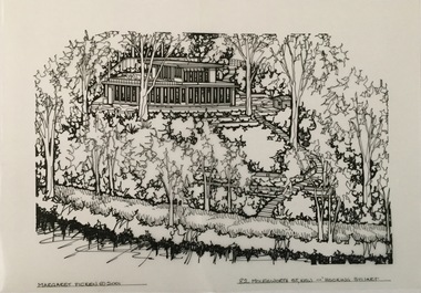
Drawing - Property Illustration, Margaret Picken, 82 Molesworth Street, Kew, 2001
After training as a Cartographic Draftsman within the mining industry, I worked as a property illustrator for real estate firms in the eastern suburbs of Melbourne for 22 years from 1983. I initially photographed houses with a Polaroid camera and made a 'thumbnail' sketch while there. The photos were used to scale off a sketch in pencil and then that sketch was overlaid with drafting film and the 'pen and ink' completed. The pens I used were the Rotring ‘Rapidigraph’ drafting pens. The ink was also made by Rotring (German).The film was ‘Rapidraw’, polyester drafting film, double matte. It takes a very fine line and doesn’t bleed. As well as house sketches, there were often floor plans and site plans ordered. Aerial sketches were ordered when the property needed an overall view. (Margaret Picken, 2020)The R Haughton James House (former) was built to a design by Robin Boyd in 1956-57. With its unusual plan form, this is one of Robin Boyd’s most important residential commissions of the period. The house was identified in heritage study as being of architectural significance at the state level. Alterations to the house were made in 1967, 1989, and 1999. This drawing is one of a series created by Margaret Picken for a number of real estate agents in Melbourne between 1983 and 2005. Each work is signed and dated by the artist.Gift of Margaret Picken, 2020Pen and ink architectural drawing on drafting film of 82 Molesworth Street, Kew by Margaret Picken.MARGARET PICKEN © 2001 / 82 MOLESWORTH ST, KEW ~ HOCKING STUARTartist -- margaret picken 1950-, architectural drawings -- houses -- kew (vic.), 82 molesworth street - kew (vic) -
 Glen Eira City Council History and Heritage Collection
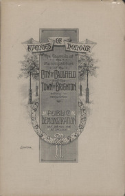
Booklet, "AVENUES OF HONOUR The Councils of the Municipalities of the CITY OF CAULFIELD TOWN OF BRIGHTON acting in conjunction PUBLIC DEMONSTRATION SAT 3rd AUG. 1918 AT 3oCLOCK"
Souvenir Programme from the Councils of the Municipalities of the City of Caulfield and the Town of Brighton for a Public Demonstration to be held on Sat 3rd August 1918 at 3 o'clock for the proposed Avenues of Honour to be planted in memory of fallen WWI soldiers. From Honour Roll Display 2019 interpretation panel - Brighton-Caulfield Avenue of Honour It is hard to imagine but a grand arboreal Avenue of Honour once lined parts of North Road, McMillan Street and Point Nepean Road (now Nepean Highway). The Avenue of Honour was a distinctly Australian phenomenon with hundreds being constructed throughout Australia during and following World War One, most of these in Victoria. Consisting of tree lined streets with each tree representing a solider, the Avenue of Honour signalled a more egalitarian approach to commemoration where rank was not a consideration. Arguably the most famous Avenue of Honour in Victoria still exists at Ballarat. Stretching for nearly 22 kilometres, the entrance to the Avenue is marked by the imposing Arch of Victory. Smaller in scale, the Brighton-Caulfield Avenue of Honour was dedicated to the ‘memory of (Brighton and Caulfield’s) kith and kin who came from (the) district and who died in the Great War’. A joint project between the neighbouring Councils, the idea was first reported in The Argus on 1 July 1918. Plans moved along quickly and on 3 August 1918 the Governor of Victoria Arthur Stanley planted the first Australian flowering gum. The next of kin were then invited to plant trees for lost sons, brothers, uncles, nephews and husbands. In all, over 400 trees were planted. Intensely personal, the Avenue also acted as a focus of grief and remembrance for the wider community. For many years, the annual civic Anzac Day service was held at the Avenue on Point Nepean Road, near Glen Huntly Road, Elsternwick. The service was moved to Caulfield Park upon the completion of the Cenotaph in 1930. Due to road widening and disease the last original tree was replaced in the 1980s, however a plaque in Caulfield Park records the Avenue’s plantation. Commemorative booklet, grey cover with text printed on the grey textured paper cover and an image of four trees and a wreath. Image of a kookaburra on the back. Inside, 28 numbered pages with b/w text and photographic images including a transparent paper representation of the proposed Avenues of Honour on Brighton Road and Point Nepean Road. Souvenir programme for a Public Demonstration for the Avenues of Honour as detailed on the front.city of caufield, world war one, first world war, anzac, remembrance, town of brighton, brighton, caulfield, avenue of honour -
 Glen Eira City Council History and Heritage Collection
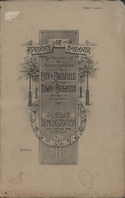
Booklet, D. W. Paterson Co. Pty. Ltd, "AVENUES OF HONOUR The Councils of the Municipalities of the CITY OF CAULFIELD TOWN OF BRIGHTON acting in conjunction PUBLIC DEMONSTRATION SAT 3rd AUG. 1918 AT 3oCLOCK SOUVENIR"
Souvenir Programme from the Councils of the Municipalities of the City of Caulfield and the Town of Brighton for a Public Demonstration to be held on Sat 3rd August 1918 at 3 o'clock for the proposed Avenues of Honour to be planted in memory of fallen WWI soldiers. One of two known copies, this copy has "Town Clerk" stamped in the upper corner, rhs.Commemorative booklet, grey cover with text printed on the grey textured paper and an image of four trees and a wreath. Image of a kookaburra on the back. Inside, 28 numbered pages with b/w text and photographic images including a transparent paper representation of the proposed Avenues of Honour on Brighton Road and Point Nepean Road. Souvenir programme for a Public Demonstration for the Avenues of Honour as detailed on the front. From Honour Roll Display 2019 interpretation panel - Brighton-Caulfield Avenue of Honour It is hard to imagine but a grand arboreal Avenue of Honour once lined parts of North Road, McMillan Street and Point Nepean Road (now Nepean Highway). The Avenue of Honour was a distinctly Australian phenomenon with hundreds being constructed throughout Australia during and following World War One, most of these in Victoria. Consisting of tree lined streets with each tree representing a solider, the Avenue of Honour signalled a more egalitarian approach to commemoration where rank was not a consideration. Arguably the most famous Avenue of Honour in Victoria still exists at Ballarat. Stretching for nearly 22 kilometres, the entrance to the Avenue is marked by the imposing Arch of Victory. Smaller in scale, the Brighton-Caulfield Avenue of Honour was dedicated to the ‘memory of (Brighton and Caulfield’s) kith and kin who came from (the) district and who died in the Great War’. A joint project between the neighbouring Councils, the idea was first reported in The Argus on 1 July 1918. Plans moved along quickly and on 3 August 1918 the Governor of Victoria Arthur Stanley planted the first Australian flowering gum. The next of kin were then invited to plant trees for lost sons, brothers, uncles, nephews and husbands. In all, over 400 trees were planted. Intensely personal, the Avenue also acted as a focus of grief and remembrance for the wider community. For many years, the annual civic Anzac Day service was held at the Avenue on Point Nepean Road, near Glen Huntly Road, Elsternwick. The service was moved to Caulfield Park upon the completion of the Cenotaph in 1930. Due to road widening and disease the last original tree was replaced in the 1980s, however a plaque in Caulfield Park records the Avenue’s plantation. Inkstamp upper corner rhs: "TOWN CLERK" -
 Surrey Hills Historical Society Collection
Book, City of Boroondara Civic Collection: (City Art and Memorabilia Collections) Cultural Heritage Review and Straegic Plan, 1996
This publication explains an approach to manage the collection and develop a strategic plan for its exposure to the public through community participation and access, interpretations and exhibitions.This publication explains an approach to manage the collection and develop a strategic plan for its exposure to the public through community participation and access, interpretations and exhibitions.boroondara council - art collections, art ad state, cultural policy, boroondara history -
 University of Melbourne, Burnley Campus Archives
Plan, Ian Porter, Civic Square, 1994
... of 3. Scale 1:200. Civic Square Plan Ian Porter ...Laminated, coloured , Preliminary Plan by Ian Porter dated 15.10.1994, No 3 of 3. Scale 1:200.civic square, ian porter -
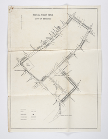 City of Greater Bendigo - Civic Collection
Document - Set of correspondence re Queen Elizabeth tour of Bendigo, Mrs T. R. Mannix, February 8th, 1954
Correspondence between Mrs T. R. Mannix, Swan Hill Wolf Cub Pack master to District Scout Commissioner Mr J. I. Samson for an invitation to be included with the local scout groups in functions to welcome Queen Elizabeth and the Duke of Edinburgh to Bendigo on Friday, the 5th of March 1954. The response from the Commissioner included typed plans of the event and maps of the royal tour through the streets of Bendigo starting and finishing at the train station.Set of correspondence including typed gatefold letter, typed plans for placement of visitors and role of the military and maps of CBD Bendigo and of Upper Reserve.queen elizabeth, duke of edinburgh, boy scout association, mayor clayton, city of greater bendigo royal visits, city of greater bendigo community groups, city of greater bendigo tourism -
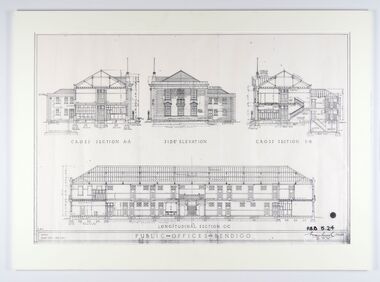 City of Greater Bendigo - Civic Collection
Work on paper - Architectural Drawing, City of Bendigo, Public Offices Bendigo, 23 November 1928
Mounted plan drawings for Public Offices in Bendigo.Cross Section A-A / Side Elevation / Cross Section B-B / Longitudinal Section C-C / R.M.B. / Scale: Eight feet - One Inch / PUBLIC OFFICES BENDIGO ? P.B.B. 5.24 / (signature) / Chief Architect / 23.11.24city of greater bendigo administration item -
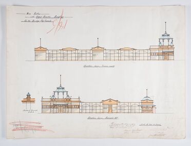 City of Greater Bendigo - Civic Collection
Work on paper - Architectural Drawing, City of Bendigo, New Baths at Upper Reserve Bendigo for the Bendigo City Council, 18th November 1912
The 'New' City of Bendigo baths also known as 'The Baths' were opened on 26th February,1913 at a cost of £2000. These baths made use of an existing dam and had men only and ladies bathing areas as well as a 'paddling paddock' for young children. This set of plans is for the Men's Bathing shed which serviced the men's bathing area adjacent to the still existing tennis courts on Barnard Street. In 1958 the Municipal Baths were replaced by an Olympic Pool and £17,000 was raised by public subscription towards this pool’s construction. Ink, pen, pencil and watercolour architectural drawing for the proposed new baths at the Upper Reserve on Barnard Street, Bendigo.New baths / at Upper Reserve Bendigo / for the Bendigo City Council / Elevation facing tennis courts / Elevation of Terminals at A, A, / Elevation facing Barnard Street / This is one of the drawings /referred to in my contract/ dated 18th November 1912 / Signed Robert J Rogers / (unknown) / Mayor Jas Semmensbendigo swimming club, rosalind park, upper reserve bendigo, faith leech memorial swimming pool, bendigo baths, city of greater bendigo community groups -
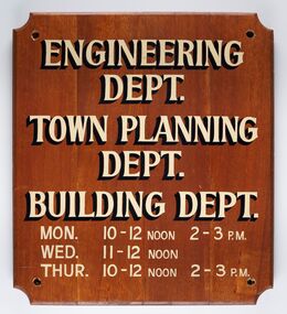 City of Greater Bendigo - Civic Collection
Sign - Municipal Departments Opening Times
History of this item is unknown but was used by one of the City, Shire or Borough Council's to advertise various department opening hours.Sign constructed from four pieces of wood. Hand painted text advertising engineering, town planning and building departments opening days and times.ENGINEERING / DEPT. / TOWN PLANNING / DEPT./ BUILDING DEPT. / MON. 10 - 12 NOON 2 - 3 PM / WED. 11 - 12 NOON / THUR. 10 - 12 NOON 2 - 3 PMcity of greater bendigo signs, city of greater bendigo administration item -
Tarnagulla History Archive
Minutes of Tarnagulla Loyal Garibaldi Lodge (1898-1901), 1898-1901
The Manchester Unity Independent Order Of Oddfellows was a friendly society beginning in England in 1840, and provided medical and other services to communities. MUIOOF became strong in gold-rush Australia, with many branches, or lodges, in country centres. Tarnagulla's Loyal Garibaldi Lodge was registered on 21 September 1861, and remained a vital part of the community for many decades. Like other Lodges, this fraternal organisation provided unemployment, sickness and funeral insurance for workers. It played an important civic role by providing financial security, a social outlet and an avenue for status advancement. By the last twenty years of the 19th century, Lodge activity was an important part of community life.Ledger containing Minutes of the Tarnagulla Loyal Garibaldi Lodge between August 1898 and August 1901. Rear pages contain Minutes of a Summons Meeting and the 10th & 11th planning meetings for the Lodge Anniversary celebration event..lodge, fraternal organisations -
Camberwell Historical Society
Booklet (Item), Sharon Town et al, City of Boroondara Civic Collection: Cultural Heritage Review and Strategic Plan, 1996
camberwell, boroondara -
Port Melbourne Historical & Preservation Society
Document - Research report, Heritage study of "Clareville" and McCormack Gallery", Robyn Clinch, Heritage Study of "Clareville"and the "McCormack Gallery" Port Melbourne, Jan 2008
Submitted as part of the requirements for the subject "Heritage Planning"at RMIT University for the degree of Master of Social Science Environment.wHeritage Study of "Clareville"and the "McCormack Gallery" Port Melbourne - A4 bound with red plastic comb. 62 pages with red back. Contains comparative studies from Port and South Melbourne, photos and mapsbuilt environment - civic, built environment - domestic, port melbourne temperance hall, town planning, heritage, robyn clinch, clareville, mccormack gallery, frederick williams, william hutcheson gresham, jane dixon, maxwell ingles, john gall, james john bartlett, edward w m suffolk, ann mcgrath suffolk, edward dicker mathews, elizabeth payne beck mathews, thomas mccormack, mathew mccormack, catherine larkin mccormack, maryann farnan mccormack, alexander james doig, alice bevan doig, stephen spadier, harriet jane blackell spadier, cricketers arms hotel -
Port Melbourne Historical & Preservation Society
Plan - Area bounded by Nott Street, Graham Street, Esplanade West and Rouse Street, Port Melbourne, 29 Feb 1952
Plan showing properties in area bounded by Nott, Graham, Esplanade W. and Rouse Streets with plan showing properties in area bounded by Station, Graham, Nott and Rouse Streets (House Common Orders) Also statistics of 1948.Top RH corner - reverse: notation - 'residential zoning amendment':Face: continuing notations (at least up to 1963):Lower, indication : 'Existing conditions 1948'built environment - commercial, built environment - civic, built environment - domestic, built environment - industrial, town planning, religion - roman catholic church (st josephs), swallow & ariell ltd, troedel & cooper pty ltd, wilsons sheet metals, franklin & anderson, g h westwood & sons, atlas plastics, w j carr, craven, robert timms, sunkist, tip top paints, knox schlapp pty ltd, daro plastics, triton construct, newmans, national bank, religion - wesleyan methodist church, court house, police station -
 Bacchus Marsh & District Historical Society
Map, Subdivision of the Manor House Property Bacchus Marsh c.1908
This land sales plan shows allotments of land offered for sale in the inner township area of Bacchus Marsh in 1908. The land put up for sale was from the estate of the late Mr and Mrs J.E. Crook. That being James Elijah Crook and his wife Harriet, (nee Athorn). The Crooks had been resident in Bacchus Marsh since the 1840s and were prominent members of the community. They were prominent in the business, social and civic affairs of the town and district. In the 1850s the Crooks acquired the Manor House and nearby land once owned by the Bacchus family. James Crook died in 1889. When Harriet Crook died in February 1908 their estate was offered for sale. This included the large stone home known as the Manor House and various parcels of land including around 50 allotments of land near the Manor House, bounded by Young, Lerderderg, Crook and Main Streets. Most of these allotments of land were sold in October 1908. The Manor House itself was passed in at the sale and continued to be owned by the Crook family for several decades after 1908.A single page map on a single page of a bound volume of maps. The map shows portions of land for sale from the subdivision of the Manor House property in Bacchus Marsh in 1908. The names of most of the buyers of the portions of land have been hand-written into the various allotments they purchased. The maps are pasted into a bound volume containing 76 maps or plans in total. High resolution digital image stored on BMDHS computer network. bacchus marsh victoria maps, land sales bacchus marsh, manor house bacchus marsh, crook family bacchus marsh -
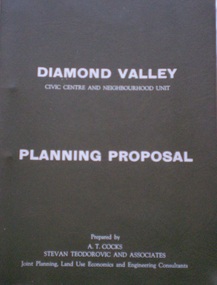 Greensborough Historical Society
Document - Planning Document, Diamond Valley Civic Centre and Neighbourhood Unit: Planning Proposal, 1960s
This document proposes the change of land use from farming and quarrying to residential. This also includes the proposal for a Civic Centre in the (then) Shire of Diamond Valley. The plans listed in the 'Schedule of Plans' on last page are missing.Includes proposal for the Aqueduct to be converted to an underground system. Includes statistics relating to population increase. Dark brown plastic folder. 23 foolscap-size pages. Maps, Application for Permits to subdivide land in the Greensborough area.partington family, mitchell family, whittingham family, albion reid, diamond valley civic centre, shire of diamond valley -
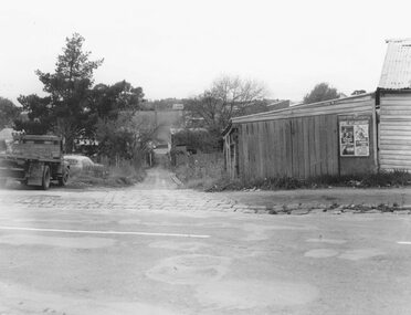 Ringwood and District Historical Society
Photograph, Edwin G. Adamson A.R.P.S, Maroondah Highway Central, Ringwood. Lane running from Adelaide St. to Warrandyte Rd.Ringwood 1963 (Eastland Litigation Photo)
This series of SS0380 photos are part of the "Eastland Litigation" launched in 1962 by the Whitehorse Traders Co-operative Association (WTCA), against the Ringwood Council's Interim Development Order of 1960. WTCA sought "orders from the Supreme Court of Victoria that the planning scheme was invalid" - See "The Eastland Litigation" chapter in "From Horse Shoes to High Heels - Ringwood Shopping Centre and Eastland 1858-2008" by Richard Carter, Bounce Books 2009.Black and White Photograph (2 copies)Written on back of photograph: "The lane running from Adelaide St. to Warrandyte Rd. Now Civic Place. Right-hand side where Jack Orr used to make clothes hoists. Left-hand side verging on plumber - S. Hunt then Horman & Woolhouse.' Stamp on photograph reads, 'Edwin G. Adamston A.R.P.S. Chartres House, Melbourne, Date May '63'. And on one copy stamped "IN THE SUPREME COURT E.W.L. 13 AUG 1963" -
University of Melbourne, Burnley Campus Archives
Plan, City Square, 1977- 1991
(1) Photocopy of plan by City of Melbourne, City Architects Office No VA47. Date not clear (January 1981?). (2) Melbourne Civic Square Stage 1, Level 2: Plan SW Sector/ Lower Square Level. Project and drawing no 7620 WT00, 20.11.1977, Revision date 10.07.1979 by Denton Corker Marshall Pty. Ltd. for Melbourne City Council. (3) Level 2: N.W. Sector. (4) Level 2: S.E. Sector. (5) Level 2: N.E. Sector. (6) Level 3 Plan: N.E. Sector Upper Square Level. (7) Level 3 Plan: S.E. Sector. (8) Melbourne City Square Diagramatic Plan: View from top of Wales Corner Building Refer 2A. (9) Melbourne Cityscope, November 5, 1990, Map 39 pp 1-2 and Map 39 June 1991. (10) Portfolio: City Square by Simon Howe, Site Inventory and Analysis, Concept Plans 1, 2, Preliminary Plan, (all Scale 1:200), Section Elevation A-A, Scale 1:100.city square, melbourne, city of melbourne, denton corker marshall pty. ltd., landscape architecture -
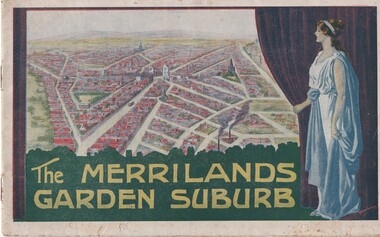 Melbourne Tram Museum
Book, T. M. Burke, "The Merrilands Garden Suburb", late 1919
Book - 12 pages with a fold out double page centre map, centre stapled, titled "The Merrilands Garden Suburb", a real estate marketing brochure for area to the west of the Reservoir rail line, known locally as Merrilands. Marketed on being a gardens suburb to the then Town Planning situation. Contains a suggested loop tram system. Has sales conditions, general information. Marketed by T. M. Burke of 340 Collin St Melbourne. Fold out surveyors map, by Saxil Tuxen, Licensed Surveyor date Oct. 1919. Shows suggested tram routes, reserves, and civic centre.trams, tramways, real estate, reservoir, proposals, new tramway, land -
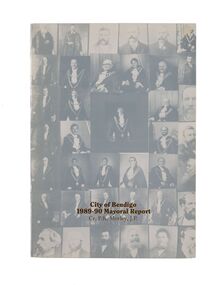 City of Greater Bendigo - Civic Collection
Financial record - Mayoral Report, City of Bendigo, 1990
Financial and civic report.A4 size Mayoral report including Councillor and Executive officer information, organisational structure, economic development, planning, family and leisure services. No mention of arts or cultural services. non-fictionFinancial and civic report.mayor morley, mayoress morley, councillor p. r. morley