Showing 829 items
matching computers
-
 Bacchus Marsh & District Historical Society
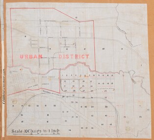
Map, Bacchus Marsh Urban District
The date of this map has not been established but the date would be sometime after 1887 as the Bacchus Marsh Railway Station, which opened in 1887, is shown on the map. A single page paper map showing blocks of land in the urban district of Bacchus Marsh. The 'urban district' is indicated by red drawn lines on the map and includes streets and blocks on the northern side of the Werribee River in Bacchus Marsh, and streets and blocks south of the Werribee in Maddingley. Scale 10 chains to 1 inch. The map is pasted into a bound volume containing 76 maps or plans in total. High resolution digital image stored on BMDHS computer network. bacchus marsh victoria maps, maddingley victoria maps -
 Orbost & District Historical Society
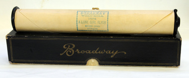
piano roll, Anglo-American Player Roll Co, 1930's
To make a piano roll, when the recording artist depresses a key on a specially wired-up piano, a signal is sent to a recording machine, which punches holes in a moving roll of paper. Originally, editing was done by punching extra holes by hand or patching unwanted holes with sticky tape but eventually the process was done by computer.• The music is A Lone Girl Flyer with the words and music by Jack O'Hagan. It was published in Melbourne by Allan's, c1930 and was dedicated to Miss Amy Johnson, a pioneering English aviator, the first female pilot to fly alone from Britain to Australia. It is an example of musical recreation of the 1930's. Brown paper roll of pianola paper (.1) in black box (.2) with lid. Broadway hard roll 1694 - A lone Girl Flyer ( march song O'Hagan). It has a duty stamp attached - Allan & Co Music Co Ltd MelbourneBroadwaypianola lone-girl-flyer johnson-amy music -
 Bendigo Military Museum
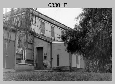
Photograph - Printing Building, Lithographic Squadron - Army Survey Regiment, Fortuna, Bendigo, c1986
This is a set of ten photographs of Lithographic Squadron’s Printing Building at the Army Survey Regiment, Fortuna, Bendigo, c1986. The building was originally George Lansell’s gold crushing battery. When the Army took possession of Fortuna in 1942, it was modified with reinforced concrete floors to house the heavy-duty printing equipment. An additional building was purpose built on the eastern side of the printing building in 1987 to house a new computer-controlled Heidelberg Speedmaster five colour lithographic offset Printing Press. See item 6131.18P for photos of foundation preparation for the new building. This is a set of ten photographs of Lithographic Squadron’s Printing Building at the Army Survey Regiment, Fortuna, Bendigo, c1986. Black and white photographs are on 35mm negative film and scanned at 96 dpi. They are part of the Army Survey Regiment’s Collection. .1) to .10) - Photos, black & white, c1986. Lithographic Squadron’s Printing Building.There are no annotations with the photos. royal australian survey corps, rasvy, army survey regiment, army svy regt, fortuna, asr, litho sqn, litho -
 Warrnambool and District Historical Society Inc.
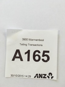
Document - ANZ queuing system ticket
This is a computer-generated coupon used in the telling transactions of customers at the Australia and New Zealand Bank in Warrnambool. The A.N. Z. Bank, the fourth largest banking group in Australia, is derived from the Bank of Australasia which was established in Sydney in 1835. The Bank of Australasia came to Warrnambool in 1854 and in 1860 large premises were built at the corner of Timor and Kepler Streets. In 1951 the Bank of Australasia merged with the Union Bank to form the A.N.Z. Bank Limited and in 1970 the E.S. & A. Bank and the London Bank of Australia merged with the A.N.Z. Bank Limited to form the A.N.Z. Banking Group Limited. This coupon is of minor interest as an example of the type of coupon used for customer banking in Warrnambool today.This is a small piece of white paper used for the telling transactions of clients in the A.N.Z. Bank in Warrnambool. It has black print on a white surface and the logo of the A.N.Z. Bank is in the right hand corner. ‘3900 Warrnambool Telling Transactions A165 30/10/2015’ ‘14.29 A.N.Z.’ a.n.z. bank warrnambool, banks in warrnambool, warrnambool history -
 Bendigo Military Museum
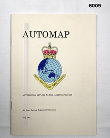
Pamphlet - AUTOMAP - Automation Applied to the Mapping Process, Major Sam Thompson US Army Corps of Engineers, 01.07.1977
This pamphlet produced by Major Sam Thompson US Army Engineer Corps on exchange to Australia was published as a guide to AUTOMAP 1, the Army Survey Regiment’s first computer-based map production system. It examined how automation had changed the compilation and drafting phases of the map production process. It attempted to present in a light-hearty story telling style, short and clear description of each AUTOMAP 1 sub-system with photos of staff and equipment, diagrams and humorous cartoons. The cartoonist is unknown. The pamphlet was printed at the Army Survey Regiment, Bendigo Army Survey Regiment pamphlet comprises a manilla card cover printed in colour with 24 pages with photographs in black and white; and descriptions, diagrams, and cartoons printed in colour. It is bounded by two staples on its spine. The coloured pages have been scanned at 300 dpi and are stored on a USB Digital Storage Device. The page images have been converted into a video (.mp4) format and also stored on the USB. The video is 1.3Mb in size and runs for 1.3 minutes.royal australian survey corps, rasvy, fortuna, army survey regiment, army svy regt, asr -
 Kiewa Valley Historical Society
Book - Ledger Commercial, unknown, Circa 1920
Historically(1920 to 1927), this ledger not only details the legible hand writing of this era but also the day to day commercial activity in the Kiewa Valley region. The neatness and the diligence of those who were required to pen the information into this ledger was a requirement by all who were involved in commercial trade be it in the city or in the rural area. Emphasis on neatness was ingrained in students at a young age. This era was well before general commercial stock computer based inventories. Generally all students of commerce required an accuracy in writing and arithmetic. Neatness and order were a "selection criteria" requirementThis item clearly identifies the Kiewa Valley as having a substantial financial hub to accommodate the various commercial enterprises within a rural environment Circa 1880's. Although Kiewa Valley had mining, agriculture, cattle and sheep it was also composed of a mixed society, encompassing all levels of society at that period. It identifies some the commercial activities(newsagency) undertaken by specific families farming in the Kiewa Valley and relates their history in the period of 1920 to 1927This ledger has a very thick cover of strong compressed cardboard. It has a cloth covering (Glued on) and is a faded blue colour. The corners of the opening side of the cover are reinforced by suede cloth,in a triangular shape, and enclose both the front and inside portions of the the ledger. The spin is reinforced by a suede section to provide increased strength and protection. The inside cover (both front and back) has an orange and brown bubbles and specks pattern. The grammage of the lined sheets (blue) is approximately 120g/m. The first twelve pages are indented and alphabetically marked with alternating red and black letters (two letters per page except for the last page which has three letters). The remaining pages are numbered in black print at the top outside edge of each page. There are 742 page numbers. Each page has thirty two blue horizontal lines and one double red line (second from top) Each page has thirteen vertical lines starting from the top horizontal double red lines and ending at the bottom of the page. These lines segregate the page into blocks for the date, the transaction and financial input. There are three double vertical red lines which designate the amount of money of each transaction (in pounds shillings,and pence).Located on the top section of the spin (in gold print on red background) "LEDGER" This is framed within a golden printed pattern of straight and squiggly lines.ledger, book keeping, 1920s commercial transactions, local kiewa valley commercial history -
 Vision Australia
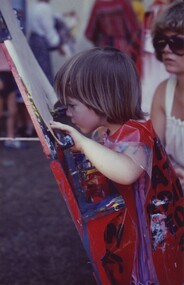
Photograph - Image, Royal Blind Society of New South Wales public relations images
Collection of images taken by the Royal Blind Society of New South Wales and used by Ron Black to promote the work of the society. These include a young child finger painting, an adult walking a rope bridge, rowing, a talking book machine (TBM), a narrator in the studio, Rob McQuillan using a TBM, staff sorting mail, transcribing print into Braille and proof reading Braille, Dawn Davis with a refreshable Braille display, and daily home living skills such as cutting up food, using a CCTV to read a newspaper and Michael Simpson using a computer in the office.14 coloured photographs previously stored in albumroyal blind society of nsw, rob mcquillan, dawn davis, michael simpson -
 Bialik College
Mixed media (Item) - 2008 Year 8 Short Films, Year 8 Short Films, 2008
The files on this cd are short films created by Year 8 students in the Film and Literature elective. Play them on a computer. Having studied short stories as a genre, students were shown how to use the simple program Movie Maker. They were asked to find a group of pictures or make their own and add music and titles to create an entertaining short story suitable for young children. These were completed in class time and it is hoped that the result can be shown to some of our junior classes for feedback. BC 2008. Please contact [email protected] to request access to this record.8 Film and Lit 2008 Short Children's Filmsfilm, literature, bialik college, 2008, 2000s, assessment -
Federation University Historical Collection
Book, Gippsland Institute Information for Prospective Students, c1989
... computers ...Aqua soft covered book relating to the Gippsland Institute. The contents include Aboriginal Studies, Accounting, Administration, Applied Science, Business, Computing, Engineering, Nursing, Psychology, Primary Teaching, Secondary teaching, Social Sciences, Visual Arts and Welfare.non-fictiongippsland institute, monash university gippsland, gippsland university college, churchill, gippsland, computing, computers, teacher education, engineering, gippsland campus, gippsland campus collection -
 Melbourne Tram Museum
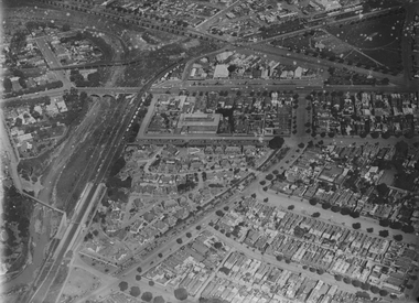
Photograph - Digital Image, Kevin O'Reilly, "Merri Creek on CD, of looking from above Rushall station towards Clifton Hill Station, c1930's
Image from CD (Compact Diskette for use in computers) - see Reg Item 135. Image titled "Merri Creek on CD, of looking from above Rushall station towards Clifton Hill Station with the Merri Creek on the left side of the photo. Shows cable trams in Queens Parade, cable trams shunting, the Clifton Hill cable tram depot, and the railway bridge over Merri Creek. 1930's? Photo has lots of white spots on the image.trams, tramways, merri creek, clifton hill, rushall station, cable trams -
 Melbourne Tram Museum
Photograph - Digital Image, Kevin O'Reilly, looking north west over the Victorian Railways Head Office in Spencer St, Late 1920's
Image from CD (Compact Diskette for use in computers) - see Reg Item 135. Image titled "Spencer" on CD, of looking north west over the Victorian Railways Head Office in Spencer St with Collins St and the Spencer St station in the top of the photo. Has cable trams in Spencer St and a cable tram set being shunted in Collins St. The top floor of the VR head office has been added (1922). Possibly late 1920's.trams, tramways, victorian railways, spencer st, collins st, cable trams -
 Bacchus Marsh & District Historical Society
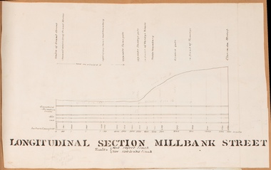
Drawing, Longitudinal Section Millbank Street Bacchus Marsh circa 1905
Millbank Street is a short street located close to the central business and shopping area of Bacchus Marsh. In the early 1900s works to improve the drainage of the street were discussed and planned by Bacchus Marsh Shire Council. This plan is most probably the plan discussed at a Shire Council meeting in April 1905. Single page plan showing a longitudinal section view of MIllbank Street running from Clarinda Street to Grant Street in Bacchus Marsh. The names of Millbank Street property owners, Cain, Shelley, Oliver and Ramsay are marked on this plan. Scale: Vertical 10 feet to 1 inch. Horizontal: 100 links to 1 inch Part of a set of maps which are pasted into a bound volume containing 76 maps or plans in total. High resolution digital image stored on BMDHS computer network. bacchus marsh victoria maps, millbank street bacchus marsh -
 Bacchus Marsh & District Historical Society
Map, Bullengarook Parish, County of Bourke
An undated parish plan map for the parish of Bullegarook. This parish area is close to the Bacchus Marsh district and borders some of the areas contained within the former Bacchus Marsh Shire and present day Moorabool Shire.A single page paper map showing the parish plan map for Bullengarook. This parish area contains the locality of Bullengarook and parts of the Wombat State Forest and is close to the town of Gisborne. A cadastral map showing land ownership. The map is not dated but a very similar map held by the State Library of Victoria is estimated to date from about 1927. The map is pasted into a bound volume containing 76 maps or plans in total. High resolution digital image stored on BMDHS computer network. bullengarook parish maps -
 Parks Victoria - Gabo Island Lightstation
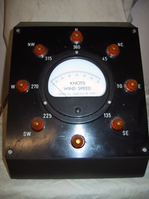
Wind speed indicator
Used to measure wind speed at Gabo Island. Max gust register and wind speed indicator were interconnected to anemometor also on display. Registor and speed / direction indicator redundant due to transition to radio transmitter and computer data recorder. This instrument for measuring wind speed by knots was made by Paton Electrical, Sydney, a radio receiving manufacturing firm which operated until c.1956. It was used in conjunction with the manual anemometer. An instrument now redundant to modern weather forecasting, it is a good example of its kind and has first level contributory significance for its historic value and provenance to the lightstation. It is a good example of its kind and has first level contributory significance for its historic value and provenance to the lightstation.Knots wind speed indicator. Housed in a black & grey metal box shaped enclosure. The front is sloped with a guage and indcator dial. Around this are eight clear orange plastic knobs with directions inscribed next to each knob.Around front in clockwise direction,"N/360, NE/45, 90/E, 135/SE, 180/S, SW/225, W/270, NW/315" On dial, 0 - 70's in 10's, "KNOTS WIND SPEED / STOCK No 6660' - 66-118-7294 / PATON ELECTRICAL SYDNEY" -
Bendigo Military Museum
Manual - National Research Council of Canada, Division of Applied Physics - Strip triangulation of measured points, National Research Council of Canada, Nov 1961, Dec 1966, Oct 1966, Jan 1967
The Royal Australian Survey Corps, Army Survey Regiment used transformations of Aerial Photographic strip and block coordinates to accurately calculate setup parameters for the extraction of topographical features on Wild B8 stereo plotters. This manual describes the methods and "Fortran" computer programming language solutions. Chapter 1 - Transformation and adjustment of strip coordinates by electronic computation. Chapter 2 - An Introduction to Analytical Strip Triangulation with a "Fortran" program. Chapter 3 - A "Fortran" program for the adjustment of Strips and Blocks by Polynomial Transformations. Chapter 4 - A modified "Fortran" (IBM 1620) program for the adjustments of Strip coordinates.Hard Covered Manual containing Chapter 1 - 8 x pages, Chapter 2 - 84 x pages, Chapter 3 - 33 x pages, Chapter 4 - 29 x pages.Distribution stamps and labels on front cover.royal australian survey corps, rasvy, fortuna, army survey regiment, army svy regt -
Federation University Historical Collection
Report, Ballarat School of Mines Submission from the School of Maths/Computing, 1985
... computers ...keith wagner, computers, computing, mathematics, ballarat school of mines, electrical trades, rural studies, andrew smail, agriculture, tom woolman, brian webber, engineering studies -
 Bendigo Military Museum
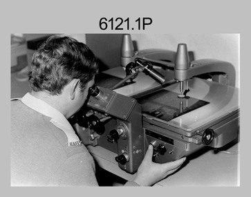
photograph - Aerotriangulation Production – Army Survey Regiment, Fortuna, Bendigo, c1980
This collection of five photos was most likely taken in 1980. Wild PUG4 point transfer devices were used by technicians in Air Survey Squadron to stereoscopically view the photography containing the survey control points and the mapping aerial photography. The Control points were transferred from the control photography to the mapping diapositives of aerial photography by drilling their locations into the photographic emulsion. The Zeiss (Jena) Stecometer analytic stereocomparator for air photography was introduced at Air Survey Squadron in 1963. Aerotriangulation production was expedited using computers for analytical photogrammetric processes. The technician accurately measured between pass, tie, and survey control points on aerial photographs.Air Survey Squadron Aerotriangulation Section - Army Survey Regiment, Bendigo. c1980. This is a set of five photographs of Air Survey Squadron personnel operating aerotriangulation equipment at the Army Survey Regiment at Fortuna, Bendigo, c1980. Photographs .1P to .4P are on 35mm negative film and were scanned at 96 dpi. Black and white photo .5P is on photographic paper and was scanned at 300 dpi. They are part of the Army Survey Regiment’s Collection. .1) - Photo, black & white, c1980, Wild PUG4 point transfer device, unidentified technician. .2) - Photo, black & white, c1980, Wild PUG4 point transfer device, unidentified technician. .3) - Photo, black & white, c1980, Wild PUG4 point transfer device, unidentified technician. .4) - Photo, black & white, c1980, Zeiss (Jena) Stecometer, unidentified technician. .5) - Photo, black & white, c1980, Zeiss (Jena) Stecometer..1P to .5P No personnel are identified.royal australian survey corps, rasvy, army survey regiment, army svy regt, fortuna, asr, air survey, aerotrig -
 RMIT Design Archives
Design drawings, Ian Wong, designer, Sheet of sketches for RMIT University's ceremonial mace
RMIT University's first ceremonial mace was commissioned by Professor David Beanland, Vice-Chancellor, Royal Melbourne Institute of Technology in 1992, and designed by Ian Wong, a lecturer in Industrial Design. It was the result of a collaborative effort, with staff from industrial design, gold & silversmithing, sculpture, engineering, applied physics, and optical technology working on its production. Materials used include carbon fibre, optical fibres, computer chips, honeycomb aluminium, gold, titanium and crystal. This design drawing shows how the University's distinctive pixel log (that conveys a sense of being at the forefront of technology) was incorporated into the design of the top element of the mace. Michelle Novacco, 2017Sketches of designs for RMIT ceremonial maceSigned bottom right corner, 'IAN WONG / iw / 1992 'ceremonial mace, industrial design -
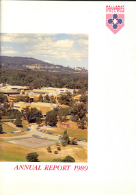 Federation University Historical Collection
Book, Ballarat University College Annual Report, 1989
The President of Ballarat University College in 1989 was E.T. Oppy.Soft covered book with an aerial photograph of the Mount Helen campus and Mt Buninyong on the cover. The annual report includes a background of the establishment and governance of Ballarat University College, Remote Sensing Laboratory, Naming of E.J. Barker Library, Computer Centre, Financial Statement The report outlines the completion of the following buildings: * Mt Helen Adminsitration Building * Mt Helen Creche *Physical education Office Extension * Geology Annex the following buildings were commenced: * Staff/Student extension * Librarianship/Business Offices 8 Art extensionballarat university college, oppy, barker, e.j. barker library -
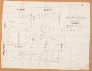 Bacchus Marsh & District Historical Society
Map, Bacchus Marsh Estate sold 30th June 1888 and sold 28 December 1895
Blocks of land in this area of Bacchus Marsh were sold in lots between 1888 and the late 1890s. This map shows sales made in 1888 and 1895.Single page map showing allotments of land bounded by Pilmer Street, Graham Street, Sydney Street and Maddingley Road (Grant Street) in Bacchus Marsh.The area is dissected by Como Street down the central area. 43 blocks of land are shown with the names of buyers or sellers in 1888 written in black in. Buyers or sellers for December 1895 are written in red ink. Part of a set of maps which are pasted into a bound volume containing 76 maps or plans in total. High resolution digital image stored on BMDHS computer network. bacchus marsh victoria maps, land sales bacchus marsh, pilmer street bacchus marsh, graham street bacchus marsh, sydney street bacchus marsh, como street bacchus marsh, maddingley road bacchus marsh, grant street bacchus marsh -
 Melbourne Tram Museum
Photograph - Digital Image, Kevin O'Reilly, looking south over the Scotch College complex, Late 1930's to mid 1940's
Image from CD (Compact Diskette for use in computers) - see Reg Item 135. Image titled "Scotch" on CD, of looking south over the eastern part of Scotch College complex with Glenferrie Road, Hawthorn on the left hand side of the photograph. The Kooyong Stadium (Tennis) constructed in 1927 now shows the new extended Northern stand added in 1934. In the top left of the photograph is the Kooyong Railway Station. A tram can be seen southbound in Glenferrie Road, adjacent to the college. late 1930's to mid 1940's trams, tramways, kooyong, hawthorn, glenferrie rd, kooyong tennis courts, scotch college -
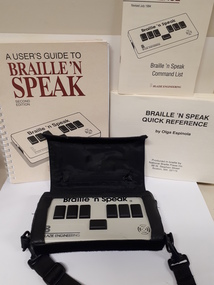 Vision Australia
Equipment - Object, Freedom Scientific, Braille 'n' Speak
A portable note taker that allow the operator to input either Grade 1 or Grade 2 Braille and have the information read back to you. It holds up to 640K of RAM or 600 Braille pages.Cardboard box containing a cream coloured plastic rectangle device with 7 black keys, 1 carry bag, 1 adapter, 1 computer cable, 1 x 3 1/4 in. Blaze demo programs disk, 1 x 3 1/4 in. Resource disk, 2 cassette tapes "Braille'n'Speak manual" by Olga Espinola, 1 print book "Quick Reference: Braille'n'Speak command list", 2 Braille books "Braille'n'Speak Quick Reference" and "A user's guide to Braille'n'Speak" both by Olga Espinola.braille equipment, assistive devices -
 Melbourne Tram Museum
Photograph - Digital Image, Kevin O'Reilly, Royal Park looking east over the Royal Park Hospital, mid 1920's
Image from CD (Compact Diskette for use in computers) - see Reg Item 135. Image titled "Royal Park 2" on CD, of looking east over the Royal Park Hospital in the north west corner of the Royal Park itself. Has the West Coburg tram line in the photograph in the top quarter. The Royal Park railway station and cutting can be seen in the top right hand corner of the photograph. Possibly late 1920's given the construction of the Royal Park tram line was completed through the park in 1925.trams, tramways, royal park, west coburg -
 Kiewa Valley Historical Society
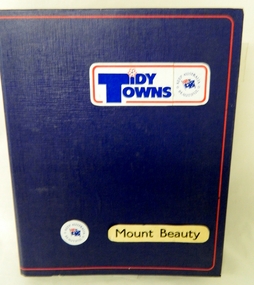
Folder - Tidy Towns, Tidy Towns Mount Beauty, 1984/85
This folder represents the true "Aussie" and the pride felt living in small rural communities. It was present in the period before the 1990's but fell so ever slightly away through the faster pace of the "modern" life evolution into a more "introspective" life style. The changes brought on by technology e.g. computers, mobile telephone "texting" and the internet has slowly impinged upon those community "get togethers" of the 1900's. Life in small rural towns and regions however have only slowly moved away from the community self worth attitudes which were so strong when life in rural areas was more insulated through physical and technologically isolation.This Tiny Towns Folder with its content is highly significant to the small town of Mount Beauty and the Kiewa Valley and its region because it represents the "true" value of rural life in the "modern" Australia. The "old" values of "mateship" and looking after the community is still very strong in the rural sector, as compared with living in the cities. The psychological and physical benefits of living in smaller rural centres is clearly demonstrated by the contents of this "Tidy Towns", keep Australia Beautiful, competition. The value of "the true blue, dinky die mateship" is still very much alive in country towns and rural environments. Although the physical isolation of yesteryear may not be so strong as the technology and population growths boost a greater interaction between city and rural folk, the ingrained attitude of comradeship still prevades. This large blue coloured lever arch folder (cloth with a red lined border) has 104 plastic pockets each with two sheets of documentation for the appraisal of the decision makers/judges of the "Keep Australia Beautiful Council (Vic), "Tidy Towns" competition.Adhesive stickers on front cover "Tidy Towns" "Keep Australia Beautiful" below this "Mount Beauty" community beautification programs, rural town pride, community pride, a town's self wrth -
 Warrnambool and District Historical Society Inc.
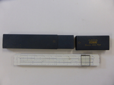
Instruments, Slide Rule, C1955
A slide rule is an instrument which is used to carry out mathematical calculations. William Oughtred is credited with its invention in 1621, however many others including Isaac Newton have made improvements or modifications over the years. From 1625 to 1800 there were approximately 40 different styles brought forward. with the following 100 years sees over 250 designs created.There have been different versions and modifications to suit scientific, mathematical and engineering requirements. It is interesting to note that many of the buildings of the 19th and 20th centuries have been designed with the use of slide rules. Their use has declined in the last 25-30 years with the advent of computers and specialist calculators.While not directly linked in any way to the history of Warrnambool, this slide rule would have been a item in use by students doing maths at upper secondary level as well as other applications which would make it a familiar object to many people.Coated bamboo with sliding metal framed glass panel or cursor . The bamboo is in three sections with the middle section movable. It is marked in various graduated measurements mainly in dark blue but with some in green and red.It is inside a dark grey rectangular box with a slide off lid on one end.There is a celluloid panel on the back with a conversion table printed on it. There is an accompanying 67 page manual with a pale green cover with black text. On slide rule:Sun Hemmi Japan No 2664S On box: Sun Hemmi Japan No 2664S warrnambool, hemmi slide rule, bamboo slide rule -
 Federation University Historical Collection
Booklet, Ballarat School of Mines, The School of Mines and Industries Ballarat, 1990
The Ballarat School of Mines was established in 1870 through initiatives of the Ballarat Mining Board which felt there was a need for such an institution because of the declining number of mine managers for the goldfields. In c1990 campuses of the Ballarat School of Mines were: Barkly Street (Business and Computer Studies, Hairdressing and Horticulture apprenticeships); Agriculture Training Centre at the Ballarat Common, Ring Road; Davey Street (Carpentry and Joinery); Ararat Campus (Business Studies, Electronics, Welding, short courses); Lake Bolac TAFE Centre (Woolclassing, Post-Primary Service Programs); Ararat Prison (Basic Education and Training Programs) Howitt Street (Bricklaying); Ballarat Airport (Motorcycle Rider Training Facility.13 page soft covered promotional book covering the Ballarat School of Mines. The book includes an historical overview, timeline, Inskill, enrolment profile, student support, E.J. T. Tippett Library, Amenities Building, L.F.J. Hillman Recreaton Centre, Hillman, Tippett. There are numerous black and white images.ballarat school of mines, ballarat mining board, peter shiells, shiells, morgan john, john cain, timeline, inskill, small business centre, leoda atkinson, m.b. john -
University of Melbourne, Burnley Campus Archives
Book - Student Records, 1991
Probably a data base for lists of names for A.P. Winzenried book, "Green Grows Our Garden" or as a mailing list to contact past students for the Centary celebrations.(1) Computer printout: alphabetical list of names and courses enrolled in, dated 09 /04/91- 09/04/91. (2) Alphabetical list of names dated 19/01/91. (3) As (1) but indexed by Postcode dated 13/08/91. (4) Graduates 1990-CRTM Graduates, Advanced Cert. Hort., Graduate Diploma in Horticulture. (Also see B10.0391 Index 1946-1986). Probably a data base for lists of names for A.P. Winzenried book, "Green Grows Our Garden" or as a mailing list to contact past students for the Centary celebrations.courses, graduates, students, crtm, advanced certificate, graduate diploma, horticulture, a.p. winzenried, green grows our garden, centenary celebrations -
![Map, Liquidator's sale, 1896. [Woolpack Estate, Bacchus Marsh]](/media/collectors/5e461d8021ea67224c82f2a1/items/6779ee97032b72846b5995f2/item-media/6779ef33032b72846b599b30/item-fit-380x285.jpg) Bacchus Marsh & District Historical Society
Bacchus Marsh & District Historical SocietyMap, Liquidator's sale, 1896. [Woolpack Estate, Bacchus Marsh]
The Woolpack Estate was an area of land owned by various landowners in the Bacchus Marsh area since the early Colonial period of the 1840s. The area was located on the eastern side of the Bacchus Marsh township about 7 kilometers from the town. The Lerderderg River ran through part of the land and so did the Melbourne to Ballarat Road. The historic Woolpack Inn associated with James Crook was also located on this land. By 1896 150 acres of this land was under the control of liquidators for the Federal Bank of Australasia who instructed that the land be sub-divided and sold in lots by public auction. A successful sale was held on 24 June 1896. Most of the blocks of land were sold for higher than expected prices and most of the buyers were people from the town and district of Bacchus Marsh. The map includes various details about the land which is described on the map as an "important sale of rich alluvial irrigable flat land in the Bacchus Marsh Valley, and other properties". The auction was conducted by the local agents W. Anderson and Bence in conjunction with Pearce Brothers also of Bacchus Marsh.A single page paper map showing a plan of 150 acres of land from the Woolpack Estate to be sold in various lots in June 1896. Also shown on the map are lots for sale at Robinson's Farm on Coimadai Creek and allotments near Bacchus Marsh railway station, including lots on Government Road (East Maddingley Road), View Street and Government Road (Parwan Road). No scale provided. The map is pasted into a bound volume containing 76 maps or plans in total. High resolution digital image stored on BMDHS computer network. land sales bacchus marsh, bacchus marsh victoria maps, woolpack estate bacchus marsh victoria -
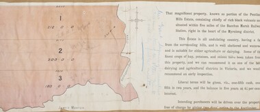 Bacchus Marsh & District Historical Society
Map, Pentland Hills Estate Land Sale 1904
The Pentland Hills Estate property shown in this auction plan was put up for sale in 1904. It was a deceased estate sale. The property had been owned by Peter Grant who died in 1899. Peter Grant had worked and farmed in the Myrniong area for many years and had also been a Councillor on the Bacchus Marsh Shire for a number of terms. A property sales report in the Express newspaper recorded that the land for sale comprised 500 acres of the old Pentland Hills Estate. It was subdivided into three lots, all of which were sold at good prices. Lot l, 212 acres was sold to Messrs Thomas and Robert Lidgett of Myrniong, at £11/15/ per acre, lot 2, 200 acres, to Mr David Robertson, of Bacchus Marsh, at £9 17/0 per acre, and lot 3, 38 acres, was sold to Mr James Norton, jun at £11 per acre. A single page paper map showing a portions of land available for sale from the Pentland Hills Estate near Bacchus Marsh.The name of the seller, Mrs Grant, can seen handwritten on this map and the buyers of the three portions for sale, Lidgett lot 1, Robertson lot 2 and Morton lot 3. Parts of the text are missing along the edges due to tearing or excessive trimming of the edges. The map is pasted into a bound volume containing 76 maps or plans in total. High resolution digital image stored on BMDHS computer network. Handwritten: Mrs Grant, Myrniong, Executrix in the deceased Estate of Mr. Peter Grant to sell by public auction.land sales, pentland hills maps, myrniong area land sales, pentland hills estate