Showing 54648 items
matching documents-maps
-
 4th/19th Prince of Wales's Light Horse Regiment Unit History Room
Document, Wilke and Co Pty Ltd, Army Training memorandum (War) (Australia) No 41, 27 Aug 1945
A document distributed to each officer providing information on some weapons and their use, Japanese sign posts, notes on flame throwers, Jap island defences, booby traps and the new grenades they were using against tanksRestricted notice. This document must not fall into enemy hands.world war 2, intelligence, japanese -
 Kiewa Valley Historical Society
Paper Sheet - Shire of Bright Plans
... maps ...Oblong sheet of paper - bright yellow (or orange). Black typed writing and subdivision maps of the Kiewa Valley Planning Scheme in the Shire of Bright. Circa 1980s2 pages of maps and scriptshire of bright, maps, kiewa valley -
 Peterborough History Group
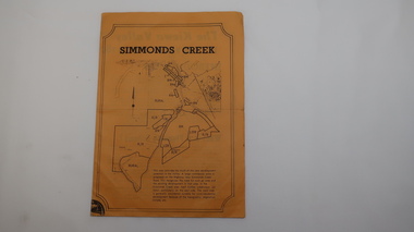
Document - Principles and Methods of History, Principles and Methods of History, Aboriginal Clans and Language
Academic description of Ken Clements' approach to research. Aboriginal clan informationPrinted A4 document, photocopied mapsbaradh clan, girai wurrung, peterborough 3270 -
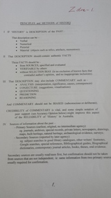
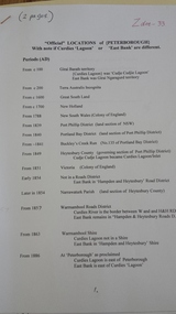 Peterborough History Group
Document - Names of town and locations
copy of gazetting of the town, history of names within the district, history of the street names in PeterboroughPhotocopied pages, map, typed documents -
Glenelg Shire Council Cultural Collection
Postcard - Postcard - Australia Map and Portland, Victoria, n.d
Coloured postcard. Map of Australia, which lifts up to reveal a strip of black and white views of Portland. Each view 4.9 x 3 cm. Representation of two 'cowboys' on horseback, with whips, to the left of map of Australia.Front: 'MAP OF AUSTRALIA FROM PORTLAND' -printed in redportland -
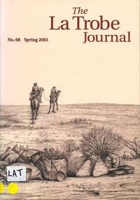 Victorian Aboriginal Corporation for Languages
Periodical, John Barnes, The La Trobe journal, 2001
... maps ...The main focus of this edition is the extensive map collection of the State Library of Victoria. Contents: From the Editorial Chair Obituary: Estelle Canning Judith Scurfield The Map Section of the State Library Miles Lewis Maps for Building Research Thomas A. Darragh This Beautiful Work of Art?: Skene and Slight's Continental Australia Gerard Hayes Annotation: Ludwig Becker's ?First Camp from Duroadoo? Susan Ballyn Jean Baptiste Lehimas de Arrieta: The First Spanish Settler in Australia? Frances Thiele Recreating the Polite World: Shipboard Life of Nineteenth-Century Lady Travellers to Australia John Barnes Library Profile: Keith Murdochmaps, b&w illustrationsmaps, state library of victoria -
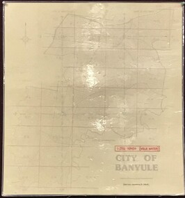 Greensborough Historical Society
Map, Banyule City Council, MMBW, 1:2500 Series. City of Banyule. Master overlay, 1994_
This master overlay is the key to the Melbourne and Metropolitan Board of Works maps: MMBW, 1:2500 Series. The overlay was made by the City of Banyule using the Melways base plan (Edition 23, 1994-95). This overlay can be used to position maps in this series.Laminated map, with overlay of MMBW map grid.mmbw, melbourne and metropolitan board of works, banyule city council -
 Creswick Campus Historical Collection - University of Melbourne
Manuscript
These items are notes and maps by K.J SimpfendorferDocuments -
Victorian Aboriginal Corporation for Languages
Book, Barry J Blake, Kulin and its neighbours, 2013
Technical linguistic grammar of Kulin languages. Documents shared vocabulary and grammatical and phonetic correspondences between languages, including Mathi Group, Colac Language, Warrnambool Language and Bunganditj.Maps, word lists, graphslinguistics, language groups, dialects, kulin, mathi, bunganditj, colac, warrnambool -
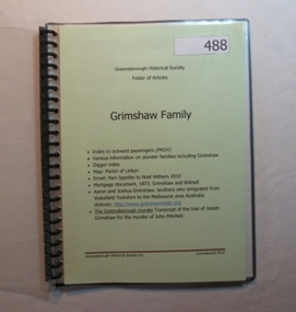 Greensborough Historical Society
Folder, Grimshaw Family, 1849o
Passenger indexes; maps; mortgage document 1873 Grimshaw and Britnell; history of Aaron and Joshua Grimshaw; Greensborough murder: transcript of the trial of Josiah Grimshaw for the murder of John Mitchell.History of the origins of this Greensborough family.20-page plastic binder, spiral bound, clear cover. Contains documents relating to the Grimshaw family.Collected by Greensborough Historical Society. Folder commenced 2012.grimshaw family -
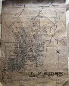 Greensborough Historical Society
Map, City of Heidelberg, City of Heidelberg, - excluding the North Ward, 1959, 27/05/1959
Map of City of Heidelberg showing municipal and ward boundaries; North Ward is excluded from this map.Blue print map"Scale 20 chns to an inch. G.M.H. 27.5.59"city of heidelberg, heidelberg - maps -
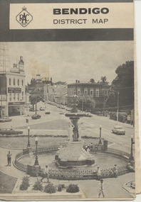 Ballarat Tramway Museum
Map, Royal Automobile Club of Victoria, "Bendigo District Map - RACV", c1971
Printed street map titled "Bendigo District Map", published by the RACV, showing the central part of Bendigo, Bendigo Outlets, streets, principal attractions, Bendigo and district maps and information, and a list of sporting and entertainment facilities. Has the tram lines shown dotted, only shows the full extent of the Golden Square line. The main map has the number "0171" in the bottom left hand corner, indicating the publication date.in ink on the Bendigo Outlet map, "3/4" along bottom edge.trams, tramways, map, bendigo, racv, railways -
Victorian Aboriginal Corporation for Languages
Conference proceedings, Joe Blythe, Maintaining the links : language, identity and the land : proceedings of the Seventh FEL Conference, Broome, Western Australia, 22-24 September 2003, 2003
Major headings: Languages & Land claims; Toponymy & Topography; Planning for the future; Language, identity & the environment; Language & Identity: Home & Away; Language revitalisation: Maintenance; Documenting ENdangered LanguagesMaps, graphs, word listsland claims, east kimberley, ecotourism, nsw, borroloola, gurr-goni, maningrida -
 National Vietnam Veterans Museum (NVVM)
Map, Long Tan Original Battle Map
Original topographical map of Long Tan area showing operational marking in black pen. Areas 1-4 marked 5RAR section.This map is the original map from 1 ATF HQ on the day of the Battle of Long Tan, 18th August, 1966.battle of long tan, map -
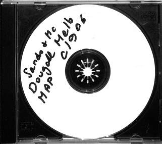 Melbourne Tram Museum
Map - CD - Sands McDougal Map Melbourne c1906, Sands McDougall
Detailed scan of the Sands McDougal Map in colour showing Melbourne's cable trams, railways, Essendon Tramways, NMETL and the Victorian Railways line to Brighton from St Kilda. Includes the MTOCo horse tram lines and the Caulfield horse tram lines. See Reg item 6572 for the actual map. Yields information about Melbourne and its tramways in 1906CD in a plastic case - black with clear cover.CD marked "Sands & McDougal Map c1906"cable trams, tramways, map, sands mcdougal, nmetl, vr trams, horse trams -
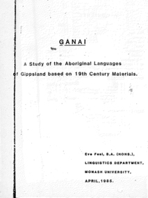 Victorian Aboriginal Corporation for Languages
Thesis, Eve Fesl, Ganai : a study of the Aboriginal languages of Gippsland based on 19th century materials, 1985
Honours thesis in linguistics (unpublished) at Monash University. Detailed studies of Gippsland languages (Ganai) including maps, extensive discussion of historical sources, and a fairly detailed grammatical study of Ganai. Includes wordlists organised by areas of meaning.Maps, word listsganai, gippsland -
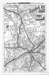 Ballarat Tramway Museum
Map, Broadbent's, "Broadbent's Map 193 Bendigo", 1950s
... maps ...Map of Bendigo showing streets, with the tram routes in dotted lines. Has a legend, scale and continuation maps. Gives an address of 475 Collins St Melbourne and a Melbourne telephone number - MR 2021.Yields information about Bendigo and its tram lines. Broadbents was a prolific publisher of maps. Map - single sided card, pocket map priced at 1/- - undated.bendigo, tramways, tram lines, maps, broadbents -
Creswick Campus Historical Collection - University of Melbourne
Map, 1980
Arboretum plant census locality mapsMap -
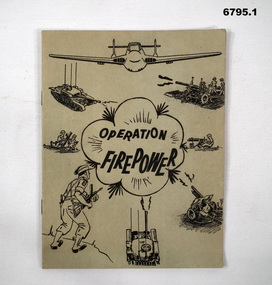 Bendigo Military Museum
Manual - TRAINING MANUALS
1. An instruction manual outlining the structure of a military exercise to practice Battle activity at a Brigade level. 2. An instruction manual outlining the proper way to read a map and the logic of it's structure. 3. Illustrative guide on what leaders should expect in relation to their soldiers. Items in the collection re Col J Swatton, refer Cat No 6719.2P for his service details.1. Green cover, 16 page booklet titled " Operation Firepower" . Dated March 1959, which planned an army exercise at Brigade Level. Outlined aim, Tactical setting, maps and plans. 2. Loose stapled 28 page manual on reading maps. Yellow paper with three folder holes punched in left size. Contains instructions and pictures and examples. 3. Brown covered manual, yellow faded pages, 60 pages inside with pictorial content displaying the do's and don't's of the behaviour of a good soldier.1. Maps have some notations, images of vehicles/weapons on front. 2. Titled " Map Reading - Supplement A.T.M. (AUST) No 12". Written on top " Colonel J.W. Swatton". 3. Titled "Right or Wrong": Element of Training and Leadership illustrated 1937". Stamp on back saying "on loan" but now donated.passchendaele barracks trust, training manuals -
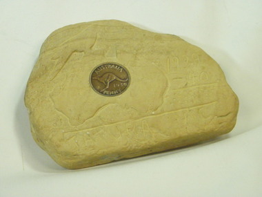 Tatura Irrigation & Wartime Camps Museum
Carving, sandstone, 1940
Item carved by a German Internee who was held in Camp 1 in WW2. Came into the possession of one of the guards, whose nephew donated it to Tatura MuseumSandstone piece with carved map of Austraiia, Tatura 1939-1940, and a 1939 penny inserted in the stone."Tatura Vic.1939-40." Map of Australia/Bird.internment camp 1, tatura, german internee.. -
![Map - Maps, [John Batman in Melbourne], 1976](/media/collectors/4f729f5697f83e03086015b8/items/60965f673c71fad916b3a651/item-media/60965fc33c71fad916b3a805/item-fit-380x285.jpg) Greensborough Historical Society
Greensborough Historical SocietyMap - Maps, [John Batman in Melbourne], 1976
... Maps ...Photocopies of 4 maps showing aspects of John Batman's time in Melbourne: Map of the settlement of the Yarra 1837; Batman's map of Port Phillip and his route of exploration, 1835, drawn by Wedge; Proposed route of Batman's initial exploratiion, and Enlargement of the Geelong region of Batman's map. No citations on any copy.Photocopy of maps, 4 pages.john batman, melbourne, port phillip -
Glenelg Shire Council Cultural Collection
Souvenir - Cloth Badge - Nelson Endeavour River Cruise, n.d
Cloth badge, oval, Nelson Endeavour River Cruise; light blue map of Australia, red arrow identifying Nelson; red ship's wheel either side, dark blue lettering, white background; white embroidered border on badge; white backing.Front: 'Nelson Endeavour' - above map "River Cruise' - below mapsouvenir, nelson river cruise -
 Melbourne Athenaeum Archives
Metal Document Box, Melbourne Athenaeum, unknown date
The box, with the name "Melbourne Mechanics' Institution" appears to have been used to store documents. Pink wax residue on the top of the lid indicates that important documents would have been kept there. The gold lettering indicates the status of the institution in the community.Metal document box with "Melbourne Mechanics' Institution" written in gold lettering on the sideA metal document box; the lid has what appears to be spots of red wax; the box is lockable but the key is missing -
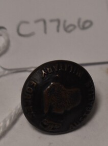 Tatura Irrigation & Wartime Camps Museum
Button
Issued to Sister Kathleen Heaphy of Australian Army Nursing service. Sister Heaphy was attached, for part of her service, to 28 Camp Hospital Internment camp 1.round brass button with a metal shank. Crown and map of Australia and wording around the circumference. A split pin is through the shanks.Australian Military Forces A crown and map of Australia australian army nursing service, sister kathleen heaphy, 28 camp hospital internment camp 1 -
Whitehorse Historical Society Inc.
Map, Nunawading Shire, 1892
... Maps ...Photocopy of an enlargement of map of Shire of Nunawading showing landowners in 1892.Photocopy of an enlargement of map of Shire of Nunawading showing landowners in 1892. Covers Middleborough Road to Ringwood boundary. One map (Blackburn) from north of Whitehorse Road to Highbury Road, 2nd map (Mitcham) Bulleen to south of Canterbury Road; 3rd map Whitehorse Road to Highbury Road.Photocopy of an enlargement of map of Shire of Nunawading showing landowners in 1892. maps, shire of nunawading, blackburn, blackburn south, nunawading, forest hill, vermont, mitcham, vermont south -
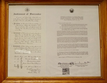 Lara RSL Sub Branch
Instrument of Surrender
A page of printed text titled 'Instrument of Surrender' and dated '9 September 1945.. It is signed by Blamey and unnamed Japanese Commander. In the top left hand corner 'LITHOGRAPHIC COPY ' is printed. Copy of an Instrument of Surrender signed by General Blamey, [at Morotai?], 9 September 1945. Physical description A page of printed text titled 'Instrument of Surrender' and dated '9 September 1945.. It is signed by Blamey and unnamed Japanese Commander. In the top left hand corner 'LITHOGRAPHIC COPY ' is printed. Rectangular in shape glass covered wooden picture frame with framing wire on the back showing copies of the surrender documents. Has a full copy of the surrender documents on the front. The back has-donated by Mr Sean Lee ww2, pacific war, japanese surrender, world war two, lara r.s.l., picture frames -
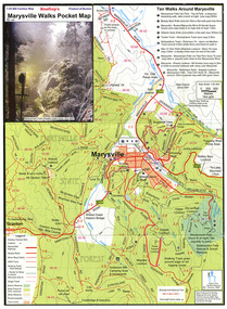 Marysville & District Historical Society
Map (Item) - Pocket map, Rooftop Mapping Services, Rooftop's Marysville Walks Pocket Map, 01-2009
A pocket map of ten walking tracks in an around Marysville. This map was published by Rooftop Mapping Services in January 2009.A pocket map of ten walking tracks in an around Marysville.marysville, victoria, australia, rooftop mapping services, steavenson falls, steavenson falls car park walk, beauty spot walk, marysville to el kanah guest house walk, gilberts gully walk, michaeldene track, man 'o' war walk, tree fern gully walk, marysville to woods lookout to mount gordon walk, keppels lookout walk -
Greensborough Historical Society
Report, Melbourne Parks and Waterways, Happy Hollow Farm Complex : Conservation Strategy [excerpts], 1996_07
This report was commissioned by the Melbourne Parks and Waterways in 1996. It contains a history of the place and building, and garden and landscape features. There is a Statement of Cultural Heritage Significance. Happy Hollow was occupied (and probably built) by Emmett Whatmough in 1893, and owned by John Cully McLaughlin. There are other family connections among the Greensborough district pioneers.Copy of document, 16 pages plus maps.happy hollow, whatmough, bell, mclaughlin, melbourne parks and waterways. cultural heritage significance -
 Flagstaff Hill Maritime Museum and Village
Parallel Rule, Early 20th Century
John Bliss (1795-1857) was born in Norwich Connecticut, trained as a silversmith and clockmaker in Vermont, and began in business as a jeweller in New York around 1830. In 1834, now trading as Bliss & Creighton, he made and marketed a range of nautical instruments. The business subsequently became John Bliss & Son in 1855 and John Bliss & Co. in 1857. It remained in business until 1957 when it was acquired by West Marine. The Bliss company used to make a range of instruments supplied to a variety of customers including the US Navy. An object made as an aid for marine navigation, to plot a course on a nautical map for a vessel to follow. The item was made by a well known American maker of nautical instruments and is significant in regards to it's provenience and history of the maker and his family who over the years had been innovators and makers of various types of nautical instruments since 1795. Parallel map ruler. Bliss of New York & Nautical instruments engraved on face of ruler, ruler divided into degrees for use on nautical mapsflagstaff hill, warrnambool, shipwrecked-coast, flagstaff-hill, flagstaff-hill-maritime-museum, maritime-museum, shipwreck-coast, flagstaff-hill-maritime-village, parallel rule, map reading, nautical object, navigation instrument -
Beechworth RSL Sub-Branch
Map confidential
Map covering the area south of Saigon shows the following AO's Duc Thanh, Debonah, Sadue, Xuyen Moc &Nui Nhon, Janette, Vung Tau special Zone and small arm ChristineExplanation of basic map reading south of saigon