Showing 490 items matching "east coast"
-
 National Vietnam Veterans Museum (NVVM)
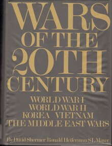
Book, Shermer, David, Wars of the 20th century: World War One. World War Two, Korea, Vietnam, The Middle East Wars
In 60 years of horrendous international strife and violence, five major wars have already changed the balance of power, ended the dominance of Europe in the world and seen the emergence of the super powers, Russia, the United States and China.In 60 years of horrendous international strife and violence, five major wars have already changed the balance of power, ended the dominance of Europe in the world and seen the emergence of the super powers, Russia, the United States and China.vietnam war, united states -
 National Vietnam Veterans Museum (NVVM)
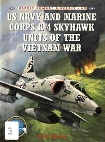
Book, Mersky, Peter, US Navy and Marine Corps A-4 Skyhawk Units of the Vietnam War
the A-4 was the backbone of the US Navy and Marine Corps' light strike force for much of the 1960s, and especially during the first half of the ten-year struggle in South-East Asia.non-fictionthe A-4 was the backbone of the US Navy and Marine Corps' light strike force for much of the 1960s, and especially during the first half of the ten-year struggle in South-East Asia.skyhawk (jet attack plane), vietnam war, 1961-1975 -- aerial operations, american., us navy, united states - marine corps -
 National Vietnam Veterans Museum (NVVM)
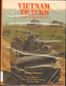
Book, Dunstan, Simon, Vietnam Tracks: Armor In Battle 1945-1975 (Copy 2)
One of the most deglected aspects of the campaigns which ravaged South East Asia and dominated the world's news media.One of the most deglected aspects of the campaigns which ravaged South East Asia and dominated the world's news media. armoured vehicles, military, vietnamese conflict, 1961-1975 - tank warfare -
 National Vietnam Veterans Museum (NVVM)
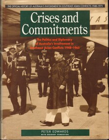
Book, Allen & Unwin, with Australian War Memorial, Crises and commitments: the politcs and diplomacy of Australia's involvement in Southeast Asian conflicts 1948-1965, 1992
Peter Edwards splendidly researched, authoritative study is official history at its best. By explaining the sources of Australia's commitment in Vietnam, and the impact of that commitment in Australia, it does a great deal to elucidate the larger, international dimensions of a war that is too often discussed only in terms of the primary participants.Peter Edwards splendidly researched, authoritative study is official history at its best. By explaining the sources of Australia's commitment in Vietnam, and the impact of that commitment in Australia, it does a great deal to elucidate the larger, international dimensions of a war that is too often discussed only in terms of the primary participants.australia - foreign relations - southeast asia, south east asia -
 National Vietnam Veterans Museum (NVVM)
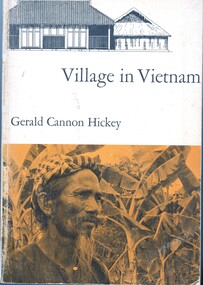
Book, Hickey, Gerald, Village in Vietnam
One of the struggles between East and West is taking place in South Vietnam, an area whose culture has been virtually unknown to scholars. The author has used the small village of Khanh Hau, in the Mekong River delta southwest of Saigon, as a microcosm for the study of the rural physical setting, the beliefs and customs of the several religions that exist here side by side, the kinship and family pattern, the crops and agricultural methods, the economic, administrative, the legal systems, and the socioeconomic structure and mobility.One of the struggles between East and West is taking place in South Vietnam, an area whose culture has been virtually unknown to scholars. The author has used the small village of Khanh Hau, in the Mekong River delta southwest of Saigon, as a microcosm for the study of the rural physical setting, the beliefs and customs of the several religions that exist here side by side, the kinship and family pattern, the crops and agricultural methods, the economic, administrative, the legal systems, and the socioeconomic structure and mobility.ethnology -- vietnam, anthropology, cultural, mekong river, khanh hau -
 National Vietnam Veterans Museum (NVVM)
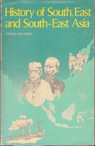
Book, Chiang, Hai Wang, History of South, East and South-East Asia
... Newhaven phillip-island-and-the-bass-coast Southeast Asia - History ...This book was written to meet the needs of students preparing for paper 6 of the Higher School Certificate History Examination.This book was written to meet the needs of students preparing for paper 6 of the Higher School Certificate History Examination.southeast asia - history, east asia - history, south asia - history -
 National Vietnam Veterans Museum (NVVM)
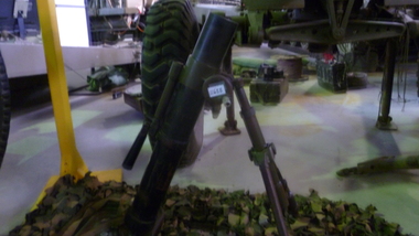
Weapon, 60mm Mortar, 1960's
... Newhaven phillip-island-and-the-bass-coast South East Asia Vietnam ...The Chinese type 31 60mm Mortar is a copy of the US M2 Mortar. The mortar consists of a barrel, bipod and baseplate. The barrel is made from ordnance steel and has a smoothbore profile. the breech end has a ball and socket arrangement that fits into the baseplate. The tripod is adjustable for traverse and elevation and can be folded for transportation purposes and is fitted with a leather binding strap. The baseplate is square in profile and is made from pressed metal. A canvas carry strap is fitted through two loops in the top surface. There are anchor spikes at the bottom of the baseplate. The mortar is painted camouflage in black, brown and olive drab.INNOC. Serial numbers : Base Plate 9307 330937; Bipod 9364south east asia, vietnam, vietcong, weapon -
 Puffing Billy Railway
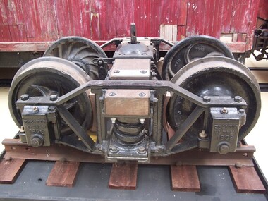
Zeehan & North East Dundas Tramway Bogie 1896, wagon bogie, 1896
Zeehan & North East Dundas Tramway Bogie 1896 The North East Dundas Tramway (NEDT) was a 2 ft (610 mm) narrow gauge tramway on West Coast Tasmania that ran between Zeehan and Deep Lead (now Williamsford). It was part of Tasmanian Government Railways. The line was opened in 1896 to carry ore from the Williamsford mines to Zeehan where it would be loaded onto another train for shipment to Burnie. The narrow-gauge (2 ft) was chosen because of the extremely difficult terrain that the railway crossed, requiring several big trestle bridges, including one at the foot of Montezuma Falls. After some rain the engine and carriages would get soaked by spray from the falls. There was a break-of-gauge with the mainline 1,067 mm (3 ft 6 in) system at Zeehan. The railway was closed in 1932. The rolling stock for the Tramway was built in the Launceston Railway workshops, and comprised twenty five eight-wheel low-side trucks, tare 3 tons 1 cwt. 1 qr., load 10 tons; six eight-wheel flat trucks, tare 2 tons 18 cwt. 1 qr., load 10 tons; two four-wheel bolster trucks, for carrying long timber, tare 1 ton 19 cwt., load 5 tons; and four passenger cars, each with six cross-seats with reversible backs, to carry eighteen passengers, also a locker for mails and parcels. All trucks and cars have cast-steel wheels 21 inches in diameter and are fitted with automatic vacuum brakes. The trucks have side levers and the cars have hand-screw brakes. The vacuum brake can be worked from the engine or from the passenger cars, which act as brake vans. When this brake was introduced, one effect was to accelerate the journey speed by about 10 minutes owing to more even running on down gradients. Historic - Industrial Narrow Gauge railway - Bogie used on the Zeehan & North East Dundas Tramway, Tasmania, Australia Bogie made from steel, iron and wrought ironZN & NTDS ML TRAM 1896 Griffinpuffing billy, bogie, zeehan & north east dundas tramway bogie, zeehan & north east dundas tramway, industrial narrow gauge railway, gauge: 2' (610 mm) -
 Uniting Church Archives - Synod of Victoria
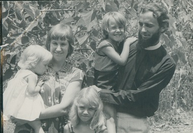
Photograph, November 1978
Ordained 1971, first Placement was at Horsham 1970-1971, then in 1972 moved to the NT and to Milingimbi 1972 to 1978; moved to Tas and the West Coast 1979-1983. Moved across to East Derwent 01.84 to 12.89, moved back to Victoria 01/90 and went to Northcote Thornbury was there until 03.96. In a Chaplaincy from 04.96 to 06/97, at Mill Park From 09/97 to 08/99, waiting for placement in 09/1999. B&W photo of Brad Harris standing outdoors with his wife and children.rev. e. bradley harris;, minister -
 Victorian Aboriginal Corporation for Languages
Periodical, Australian Institute of Aboriginal and Torres Strait Islander Studies, Australian Aboriginal studies : journal of the Australian Institute of Aboriginal and Torres Strait Islander Studies, 2009
Social Engineering and Indigenous Settlement: Policy and demography in remote Australia John Taylor In recent years neo-liberals have argued that government support for remote Aboriginal communities contributes to social pathology and that unhindered market engagement involving labour mobility provides the only solution. This has raised questions about the viability of remote Aboriginal settlements. While the extreme view is to withdraw services altogether, at the very least selective migration should be encouraged. Since the analytical tools are available, one test of the integrity of such ideas is to consider their likely demographic consequences. Accordingly, this paper provides empirically based speculation about the possible implications for Aboriginal population distribution and demographic composition in remote areas had the advice of neo-liberal commentators and initial labour market reforms of the Northern Territory Emergency Response been fully implemented. The scenarios presented are heuristic only but they reveal a potential for substantial demographic and social upheaval. Aspects of the semantics of intellectual subjectivity in Dalabon (south-western Arnhem Land) Ma�a Ponsonnet This paper explores the semantics of subjectivity (views, intentions, the self as a social construct etc.) in Dalabon, a severely endangered language of northern Australia, and in Kriol, the local creole. Considering the status of Dalabon and the importance of Kriol in the region, Dalabon cannot be observed in its original context, as the traditional methods of linguistic anthropology tend to recommend. This paper seeks to rely on this very parameter, reclaiming linguistic work and research as a legitimate conversational context. Analyses are thus based on metalinguistic statements - among which are translations in Kriol. Far from seeking to separate Dalabon from Kriol, I use interactions between them as an analytical tool. The paper concentrates on three Dalabon words: men-no (intentions, views, thoughts), kodj-no (head) and kodj-kulu-no (brain). None of these words strictly matches the concept expressed by the English word mind. On the one hand, men-no is akin to consciousness but is not treated as a container nor as a processor; on the other, kodj-no and kodj-kulu-no are treated respectively as container and processor, but they are clearly physical body parts, while what English speakers usually call the mind is essentially distinct from the body. Interestingly, the body part kodj-no (head) also represents the individual as a social construct - while the Western self does not match physical attributes. Besides, men-no can also translate as idea, but it can never be abstracted from subjectivity - while in English, potential objectivity is a crucial feature of ideas. Hence the semantics of subjectivity in Dalabon does not reproduce classic Western conceptual articulations. I show that these specificities persist in the local creole. Health, death and Indigenous Australians in the coronial system Belinda Carpenter and Gordon Tait This paper details research conducted in Queensland during the first year of operation of the new Coroners Act 2003. Information was gathered from all completed investigations between December 2003 and December 2004 across five categories of death: accidental, suicide, natural, medical and homicide. It was found that 25 percent of the total number of Indigenous deaths recorded in 2004 were reported to, and investigated by, the Coroner, in comparison to 9.4 percent of non-Indigenous deaths. Moreover, Indigenous people were found to be over-represented in each category of death, except in death in a medical setting, where they were absent. This paper discusses these findings in detail, following the insights gained from the work of Tatz (1999, 2001, 2005) and Morrissey (2003). It also discusses a further outcome of this situation - the over-representation of Indigenous people in figures for full internal autopsy. Finding your voice: Placing and sourcing an Aboriginal health organisation?s published and grey literature Clive Rosewarne It is widely recognised that Aboriginal perspectives need to be represented in historical narratives. Sourcing this material may be difficult if Aboriginal people and their organisations do not publish in formats that are widely distributed and readily accessible to library collections and research studies. Based on a search for material about a 30-year-old Aboriginal health organisation, this paper aims to (1) identify factors that influenced the distribution of written material authored by the organisation; (2) consider the implications for Aboriginal people who wish to have their viewpoints widely available to researchers; and (3) assess the implications for research practice. As part of researching an organisational history for the Central Australian Aboriginal Congress, seven national and regional collections were searched for Congress?s published and unpublished written material. It was found that, in common with other Aboriginal organisations, most written material was produced as grey literature. The study indicates that for Aboriginal people and their organisations? voices to be heard, and their views to be accessible in library collections, they need to have an active program to distribute their written material. It also highlights the need for researchers to be exhaustive in their searches, and to be aware of the limitations within collections when sourcing Aboriginal perspectives. Radiocarbon dates from the Top End: A cultural chronology for the Northern Territory coastal plains Sally Brockwell , Patrick Faulkner, Patricia Bourke, Anne Clarke, Christine Crassweller, Daryl Guse, Betty Meehan, and Robin Sim The coastal plains of northern Australia are relatively recent formations that have undergone dynamic evolution through the mid to late Holocene. The development and use of these landscapes across the Northern Territory have been widely investigated by both archaeologists and geomorphologists. Over the past 15 years, a number of research and consultancy projects have focused on the archaeology of these coastal plains, from the Reynolds River in the west to the southern coast of the Gulf of Carpentaria in the east. More than 300 radiocarbon dates are now available and these have enabled us to provide a more detailed interpretation of the pattern of human settlement. In addition to this growing body of evidence, new palaeoclimatic data that is relevant to these northern Australian contexts is becoming available. This paper provides a synthesis of the archaeological evidence, integrates it within the available palaeo-environmental frameworks and characterises the cultural chronology of human settlement of the Northern Territory coastal plains over the past 10 000 years. Ladjiladji language area: A reconstruction Ian Clark and Edward Ryan In this reconsideration of the Ladjiladji language area in northwest Victoria, we contend that while Tindale?s classical reconstruction of this language identified a fundamental error in Smyth?s earlier cartographic representation, he incorrectly corrected that error. We review what is known about Ladjiladji and through a careful analysis demonstrate not only the errors in both Smyth and Tindale but also proffer a fundamental reconstruction grounded in the primary sources.ladjiladji, social engineering, dalabon, indigenous health, coronial system, radiocarbon dating -
 Victorian Aboriginal Corporation for Languages
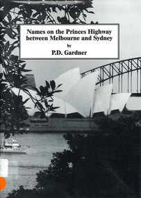
Book, P D Gardner, Names on the Princes Highway between Melbourne and Sydney : their origins, meanings and history, 2000
Place name list in a specific area. Giving descriptions and meanings.Maps, b&w illustrationsdandenong, genoa, south coast nsw, yarra river, moruya, kiama, captain cook, east gippsland, rosedale -
 Uniting Church Archives - Synod of Victoria
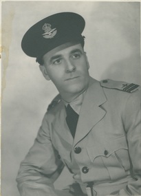
Photograph, 1944
Rev Ira Menear (1901 - 1977). Born at Kapunda. Worked at the Kimba and Pt Neill mission stations on the west coast of South Australia before studying at the Brighton Training College and Adelaide University. Graduated B.A. Adelaide University 1928. After completing his theological training he was appointed to the Norwood Circuit before being appointed to take charge of the Methodist Inland Mission at Cloncurry. Minister at Crow's Nest, Gympie & Rockhampton 1936 - 1940. In 1940 he was accepted as a pilot officer in the RAAF, having been given leave of absence by the Methodist Conference. Menear enlisted RAAF air crew but was later transferred to the administrative staff. He rose from A.C.1 to the rank of Acting Wing Commander. He served in many parts of Australia, including the Darwin area. After the war Rev Menear took charge of the Commonwealth Rehabilitation Centre at Mount Osmond and later Mount Breckan, Victoria Harbour Rehabilitation Centre. B & W waist length studio portrait of Rev. Ira Menear dressed in his RAAF Flt. Lt. uniform."Seasons Greetings I Menear F/LT Control Officer Operations Room Pearce W.A."ira menear, methodist, minister, adelaide university, brighton training college, methodist inland mission, cloncurry, raaf, commonwealth rehabilitation centre -
 Uniting Church Archives - Synod of Victoria
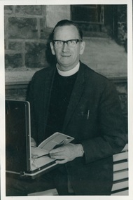
Photograph, Undated, c. 1970s
Born on the West Coast of Tasmania. Became a teacher inTasmania in the early 1930. He married Emily Ferguson, a presbyterian girl, but felt a calling to the Methodist Church. John went to Underbool in Vic in 1939. Joined the RAAF in 1942 and trained as a Navigator for Bomber Command. Was recalled in 1943 and began his ministry in the Woomelang Circuit, then at Mitiamo 1947-1950; Port Fairy 1950-52; Nathalia 1952-54. He left the ministry and bought a small farm near Bendigo. After 18 mths he started preaching at Mckenzie Street Methodist church with the title Pastor. In 1958 he was recalled to the ministry and served at Morwell. He was also chaplain to Morwell River Prison, Newport West, Coburg, Milan Italy and Finally at Moonee Ponds where he retired in 1978. After retirement he did supply work in places such as Sea Lake, Heathcote, Warragul and Quirindi NSW. John died on 25 July 2000. B & W photograph of Rev. John Adamthwaite standing in front of an open briefcase.john adamthwaite, methodist, minister -
 Koorie Heritage Trust
Journal - Periodical, Barrett, Charles, Northern Australia
... , from Darwin to the farthest east coast of Arnhem Land. pp40 ...This book covers the far northern parts of Australia, from Queensland to the Kimberleys and the romantic ports of the north-west, where early navigators made landfalls. Tthe photographs, many of them unique, were taken on sea and land expeditions, the latest in 1939, when a 1200 miles' cruise was made in the mission boat Larrpan, from Darwin to the farthest east coast of Arnhem Land.pp40; illus; 27 cm.This book covers the far northern parts of Australia, from Queensland to the Kimberleys and the romantic ports of the north-west, where early navigators made landfalls. Tthe photographs, many of them unique, were taken on sea and land expeditions, the latest in 1939, when a 1200 miles' cruise was made in the mission boat Larrpan, from Darwin to the farthest east coast of Arnhem Land.aborigines-northern australia, port essington, northern australia-aborigines-fishing, aboriginal women-northern australia-food gathering, goulburn island, elcho island, caledon bay, milingimbi, wessel islands, thursday island, wyndham, broome., aboriginal art - cave paintings -
Tramways/East Melbourne RSL Sub Branch - RSL Victoria Listing id: 27511
Book, Patrick Lindsay et al, THE COAST WATCHERS (The men behind the lines who saved the pacific), 2010
940.5426, historical, isbn: 978 1 742575 3126 -
Tramways/East Melbourne RSL Sub Branch - RSL Victoria Listing id: 27511
Book, ERIC FELDT et al, THE COAST WATCHERS, 1991
940.548694, historical, isbn: 0 14 01.4926 0 -
 Kew Historical Society Inc
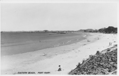
Photograph - East Beach from Battery Hill, Port Fairy, c.1926
Henry Beater Christian (1886-1962) , was a descendant of one of the earliest settler families in Kew. Employed at the Kew Asylum as a 'public servant', he was a skilled amateur photographer, photographing numerous scenes in Kew and on his travels around Victoria. The majority of his photographs date from 1916 to 1929. His finest photographs are housed in two photograph albums. Digital copy of a photograph from page 23 of the 47-page photograph album containing 261 gelatinous silver images, loaned by Diane Washfold with permission given to digitise and hold a copy in our collection. In the 1920s, the photographer travelled throughout Victoria, including on the west coast from Port Campbell to Port Fairy. Trips were presumably made by train and by foot. Lynda Tieman and her team at the Port Fairy Historical Society have tentatively identified a number of Henry Christian's photographs of Port Fairy, of which this is one. The photo is believed to be of East Beach from Battery Hill.henry beater christian (1886-1962), landscape photography, christian-washfold collection, photograph albums, east beach -- port fairy (vic.), battery point, port fairy -
 Port Fairy Historical Society Museum and Archives
Photograph, Valentine Publishing Co, Eastern Beach Port Fairy
Early view looking towards Griffiths Island showing the dunes with vegetation on themReflects change in coast over timeBlack and white photograph of curve of East BeachEastern Beach Port Fairy 16beach, sea, seascape, east beach -
 Wodonga & District Historical Society Inc
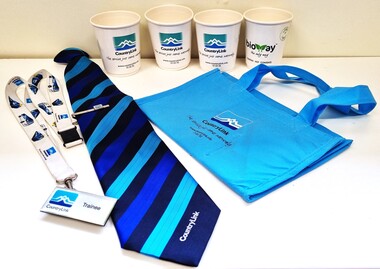
Memorabilia - CountryLink Collection
For residents of Northeast Victoria, railway services have provided a critical link between the area and state capital cities. CountryLink was established in January 1989 under the Transport Administration Act 1988. It was a passenger rail and road service brand that operated in regional areas of New South Wales, and to and from Canberra, Brisbane and Melbourne. CountryLink operated rail services a fleet of XPT and locomotive-hauled passenger trains. The Southern region of the Country Link network covered New South Wales districts of Illawarra, South Coast, Snowy Mountains, South West Slopes, Southern Tablelands, Riverina and Sunraysia regions plus the Australian Capital Territory and parts of Victoria. The Government of Victoria contributed to the provision of these services. Services ran along the Main South line from Sydney Central station to Albury before continuing on the North East line to Southern Cross station in Melbourne. The Sydney/Melbourne Express ceased in November 1993 and was replaced by an XPT in November 1993 In December 1994, a daylight service to Melbourne resumed by extending the Riverina XPT from Albury. In July 2013, CountryLink was merged with the intercity services of CityRail to form NSW TrainLink.These items are connected to a major transportation system in eastern Australia.A collection of uniform items and memorabilia from the CountryLink rail service. They include a tie and tiepin, staff badge and lanyard, cups and a bag with CountryLink logo.Tag on tie: Stylecore Corporate Wear Australia/ Polyester/ Made in England On all items: CountryLinkcountrylink, australian railways, countrylink uniforms -
Lakes Entrance Historical Society
Book, Calder Stuart and Winty, East Cunninghame and Lake Tyers Beach. A case study Report, 1976
A case history of resort development in the Lake Tyers Beach Victoria coast area, considering the history of land use and future planning with regard to environmental impact and social requirements.natural history, land settlement -
 Victorian Railway History Library
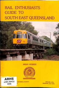
Book, Webber, Brian, Rail Enthusiasts Guide to South East Brisbane, 1994
A guide to railway locations for railway enthusiasts visiting the south eastern suburbs of Brisbane & the Gold Coast in Queensland.ill, maps, p.80.non-fictionA guide to railway locations for railway enthusiasts visiting the south eastern suburbs of Brisbane & the Gold Coast in Queensland.railroad operations - queensland - history, railroads - queensland - history -
 Flagstaff Hill Maritime Museum and Village
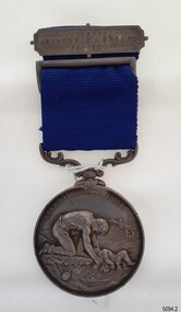
Award - Medal, ca. 1872
This medal is the Liverpool Shipwreck and Humane Society’s “Bramley-Moore medal for saving life at sea 1872”. The Society was formed in 1839. In 1872 Mr John Bramley-Moore donated £500 on condition that the medal have the specific inscription above on its reverse. The Bramley Morre medal was first awarded in 1874 and records show that since that time only one gold medal has been awarded, twenty-two silver medals and seventeen bronze medals, the last being in 1945. This Bromley-Moore medal was awarded to Peter Carmody for his bravery in saving lives on the Newfield shipwreck. The Newfield was a three-masted iron and steel barque, built in Dundee, Scotland, in 1889 by Alexander Stephen and Sons. It was owned by the Newfield Ship Company in 1890 and later that year It was registered in Liverpool to owners Brownells and Co. The Newfield left Sharpness, Scotland, on 28th May 1892 with a crew of 25 under the command of Captain George Scott and on 1st June left Liverpool. She was bound for Brisbane, Australia, with a cargo of 1850 tons of fine rock salt, the main export product of Sharpness. At about 9pm on 28th August 1892, in heavy weather, Captain Scott sighted, between heavy squalls, the Cape Otway light on the mainland of Victoria but, due to a navigational error (the ship’s chronometers were wrong), he assumed it to be the Cape Wickham light on King Island, some 40 miles south. He altered his course to the north, expecting to enter Bass Strait. The ship was now heading straight for the south west Victorian coast. At about 1:30am the Newfield ran aground on a reef about 100 yards from shore and one mile east of Curdie’s Inlet, Peterborough. The ship struck heavily three times before grounding on an inner shoal with 6 feet of water in the holds. Rough sea made the job of launching lifeboats very difficult. The first two lifeboats launched by the crew were smashed against the side of the ship and some men were crushed or swept away. The third lifeboat brought eight men to shore. It capsized when the crew tried to return it to the ship for further rescue The rescue was a difficult operation. The Port Campbell Rocket Crew arrived and fired four rocket lines, none of which connected with the ship. Peter Carmody, a local man, volunteered to swim about one mile off shore to the ship with a line to guide the fourth and final lifeboat safely to shore. He was assisted by James McKenzie and Gerard Irvine. Seventeen men survived the shipwreck but the captain and eight of his crew perished. The Newfield remained upright on the reef with sails set for a considerable time as the wind slowly ripped the canvas to shreds and the sea battered the hull to pieces. The Marine Board inquiry found the wreck was caused by a "one man style of navigation" and that the Captain had not heeded the advice of his crew. According to Jack Loney ‘… when the drama was over . . the Newfield was deserted except for the Captain’s dog and two pigs.’ Peter Carmody was awarded the Bramley-Moore medal by the Liverpool Shipwreck and Humane Society for Saving Life at Ssea, which he received by mail on January 21st 1893. The medal and a letter of congratulations were donated to Flagstaff Hill Maritime Museum by Peter Carmody’s grand-daughter Norma Bracken and her son Stuart Bracken on 25th May 2006. The Medal and Letter of Congratulations join other items in the Newfield collection.The Carmody Medal recognises the bravery of Peter Carmody in risking his life to rescue crew members of the Barque Newfield when it was wrecked near Curdies Inlet in August 1892. The ‘Bramley-Moore medal for saving life at sea, 1872’ was presented by the Liverpool Shipwreck and Humane Society. The medal and accompanying letter have local and international historic significance as they demonstrate both the difficulties associated with navigation and the dangers of shipping along the South West Coast of Victoria in the 19th century and the medal’s association with the Liverpool Shipwreck and Humane Society and John Bramley-Moore, who provided £500 to found the Bramley-Moore medal. The medal is socially significant. It emphasises the importance of Peter Carmody in rescuing victims of shipwrecks with little thought for his own safety. The medal reminds us of the importance of local people to Victoria’s maritime history. The Carmody Medal and Humane Society letter were in the Carmody family until they were presented to Flagstaff Hill Maritime Village, by the grand-daughter and great-grandson of Peter Carmody, on the 25th May 2006. The medal is significant for its complete provenance recorded in the donation documentation. The medal is in very good condition and relatively rare with only 22 silver medals awarded between 1874 and 1945. The Carmody Medal and letter add a human element to the story of the shipwrecks. They give life and significance to the Newfield, its victims and its artefacts. Bramley-Moore medal from the Liverpool Shipwreck and Humane Society, awarded to Peter Carmody. The round,silver medal is attached to a looped blue ribbon by a decorative, swivelling silver connector. The top of the ribbon has a silver pin bar threaded through it. The obverse of the medal has a design of a man kneeling on a floating part of a wreck. He is rescuing a child from the sea. There is a manned boat in the distance rescuing someone from the sea. In the far background there is a sailing ship. The top third of the medal has an inscription around it. The reverse shows a long-legged hen cormorant with extended wings holding an olive branch in its beak. The bird is surrounded by a wreath of oak leaves made from two branches. There is an inscription between the design and the rim that goes all the way around the circumference. There is a name engraved around the edge of the medal. The medal in embedded in a purple velvet panel that rests inside a brown, leather-covered case. The lid of the case has a gold embossed emblem in the cemtre. Both the lid and base have a rectangular gold border. The lid is attached to the base with two brass hinges. The base has a brass push-button catch. The box is lined with padded cream silk. The lining inside the lid has a gold emblem in the centre.The obverse has the words "LORD, SAVE US, WE PERISH". The reverse has the words "BRAMLEY-MOORE MEDAL FOR SAVING LIFE AT SEA" and "1872". Around the edge of the medal are the words "PETER CARMODY, FOR HAVING BEEN MAINLY INSTRUMENTAL IN RESCUING THE CREW OF THE BARQUE NEWFIELD, AUG 29 1892" The pin bar has the words “LIVERPOOL SHIPWRECK & HUMANE SOCIETY” written across it. The gold embossed emblem on the lid of the box has the words in the centre "SHIPWRECK AND …. …. ….FOUNDED 1839" The gold emblem on the cream silk lining has the words “BY APPOINTMENT ELKINGTON & CO” printed on it.medal, shipwrecked coast, flagstaff hill, flagstaff hill maritime museum, maritime museum, flagstaff hill maritime village, shipwreck coast, warrnambool, peter, peter carmody, carmody, bramley moore, newfield, liverpool shipwreck and humane society, 1892, 28 august 1892, august 1892, port campbell, bravery, shipwreck, rescue, nineteenth century, ship, curdie s river, victorian shipwrecks, barque, stuart bracken, norma bracken, gerard irvine, james mckenzie -
 Lakes Entrance Historical Society
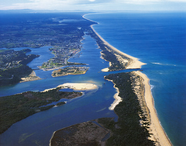
Photograph - Lakes Entrance, 1985c
Photo was cut from Tourist brochureColour photograph showing aerial view of township and the Ninety Mile Beach. Pecks factory on Bullock Island, Old North Arm bridge, bitumen for carpark for future. Fishermen's Club near North Arm Bridge. Photo shows East end of Rigby Island and Snake Island. Glimpse of Red Bluff, Lake Bunga and Lake Tyers in far east. Lakes Entrance Victoriabridges, coast, waterways, topography, township -
 Wangaratta RSL Sub Branch
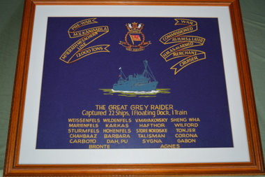
Print - Framed print, The Great Grey Raider
On the night of August 24, 1941 HMS Kanimbla, with 300 Indian troops on board led a flotilla in a surprise attack on the Iranian port of Bandar Shahpur capturing eight German and Italian merchant vessels all containing valuable cargoes, as well as two Iranian gunboats and a floating dock. Kanimbla went alongside the burning Italian tanker Bronte and fought the fires while engaging a train with her main armament and with her 3-inch guns. She remained in the region until October 11, supervising the port and carrying out salvage work on the captured vessels, including salvage work on the German freighter Hohenfels. After further work in Indian waters during the latter part of October and November, Kanimbla proceeded to Singapore and escorted the first convoy out of that city after the Japanese attack on Malaya. She arrived in Melbourne on Christmas Day. She carried out further convoy work off the Australian coast and in both the Indian and the Pacific Oceans. At the end of the war HMAS Kanimbla was employed in repatriating Australian servicemen from the Pacific Islands and also in returning Dutch dependents to the East Indies (Indonesia). Between October 1946 and June 1948 she sailed between Australia and Japan transporting British Commonwealth Occupation Forces. MS Kanimbla was unique for many reasons, she was the only passenger liner in history to have a fully operational radio broadcasting station built into the ship at the time of construction. The equipment was manufactured by AWA in Australia and had been shipped to Ireland for installation whilst the ship was still under construction.Brown timber frame housing white mount and dark blue print with grey ship in the centre above list of names below and top right and left corners.THE GREAT GREY RAIDER Captured 22 Ships, / Floating Dock, / 1Train Ships captured: Weissenfels, Wildenfels, V. Mayakovsky, Sheng Wha, Marienfels, Karakoram, Hathor, Winford, Sturmfels, Hohenfels, Store Nordiske, Tonjer, Chahbaaz, Barbara, Talisman, Corona, Carboto, Dah Pu, Sygna, Gabon, Bronte, Agnes Pre War: M.V. Kanimbla, McIlrath McEachern Line, 12000 Tons War: Commissioned as H.M.S. & Later H.M.A.S as armed Merchant Cruiserkanimbla, great grey raider, hohenfels, bronte, ww2, 1941 -
 Flagstaff Hill Maritime Museum and Village
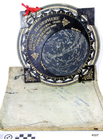
Planisphere, Early 20th Century
The word Planisphere (Latin planisphaerium) was originally used in the second century by Claudius Ptolemy to describe the representation of a spherical Earth by a map drawn in the plane. This usage continued into the Renaissance: for example Gerardus Mercator described his 1569 world map as a Planisphere. The word describes the representation of the star-filled celestial sphere on the plane. The first star chart to have the name "Planisphere" was made in 1624 by Jacob Bartsch. Bartsch was the son-in-law of Johannes Kepler, discoverer of Kepler's laws of planetary motion. A significant item of celestial mapping used by marine navigators This particular item was made and used in the first quarter to half of the 20th centuryPlanisphere of northern hemisphere, with canvas bag. Planisphere consists of a circular star chart attached at its centre to an opaque circular overlay that has a clear elliptical window or hole so that only a portion of the sky map will be visible in the window or hole area at any given time. The chart and overlay are mounted so that they are free to rotate about a common pivot point at their centres. The star chart contains the brightest stars, constellations and (possibly) deep-sky objects visible from a particular latitude on Earth. The night sky that one sees from the Earth depends on whether the observer is in the northern or southern hemispheres and the latitude. A Planisphere window is designed for a particular latitude and will be accurate enough for a certain band either side of that. Planisphere makers will usually offer them in a number of versions for different latitudes. Planispheres only show the stars visible from the observer's latitude; stars below the horizon are not included. A complete twenty-four-hour time cycle is marked on the rim of the overlay. A full twelve months of calendar dates are marked on the rim of the starchart. The window is marked to show the direction of the eastern and western horizons. The disc and overlay are adjusted so that the observer's local time of day on the overlay corresponds to that day's date on the star chart disc. The portion of the star chart visible in the window then represents (with a distortion because it is a flat surface representing a spherical volume) the distribution of stars in the sky at that moment for the Planispheres designed location. Users hold the Planisphere above their head with the eastern and western horizons correctly aligned to match the chart to actual star positions. "Made in Germany for GEORGE PHILIP & SONS Ltd. Geographical and Educational Depot, 32 Fleet Street, London" Canvas bag has "Capt. H (Howard) Tyler from Captain H. F. Woolf" "Tyler 22 ? St East Brighton" also "13 Halls St Flinders"flagstaff hill, warrnambool, shipwrecked-coast, flagstaff-hill, flagstaff-hill-maritime-museum, maritime-museum, shipwreck-coast, flagstaff-hill-maritime-village, planisphere, star map, marine navigation, maps, george philip & sons -
 Flagstaff Hill Maritime Museum and Village
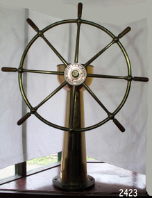
Equipment - Ship's Wheel, John Hastie et al, Early 20th Century
John Hastie Engineer and millwright John Hastie opened small manufacturing works in Greenock in 1845 and 1853 patented the first self-holding steering gear. The firm became known as John, Hastie and Co. Ltd. in 1898 after taking on limited liability status and their main works were at Kilblain Street, Greenock, where they specialised in ships' steering gear. The company also occupied works at Rue End Street, Greenock. Plans of this unit depict a stockyard to the east, with areas for welding; fitting and assembly; flame, cutting and fabrication; and a machine bay. The company was dissolved in 1991. Brown Brothers Brown Bros Rosebank Ironworks made the steering gears for many large ship's, including The Titanic. Andrew Betts Brown the founder was born in 1741 and closely associated with many improvements in marine engineering. He was educated in his native city and served his apprenticeship as an engineer in the locomotive works of the North British Railway Company at St. Margaret's. During his apprenticeship, he attended the evening classes at Watt College. subsequently going to Manchester to study chemistry. He went to London around 1863 and took over an old brewery, which he converted into an engineering works. During his time there he invented an overhead travelling crane, which was used on the construction of Blackfriars Bridge London. He went on to develop plant which used steam and hydraulic power for discharging ships as a result the company was contracted to install this equipment in Hamburg Docks. By around 1870 he continued to construct machinery in London but realised that conditions were more favourable in Edinburgh. He acquired land at Rosebank adjoining the North British Railway Company's line to Granton, and the necessary infrastructure was completed allowing him to finish the Hamburg contract. The works at Rosebank were eventually extended and added to until they became one of the largest engineering works in the East of Scotland. Mr Brown was a member of numerous engineering institutions, the best known at the time being the Institution of Naval Architects. He was also a Fellow of the Royal Society of Edinburgh, a member of the Institute of Mechanical Engineers and of the Institution of Marine Engineers he died in 1906 at the age of 67.An item made by two marine innovators of marine auxiliary machinery, equipment and itemsShip's wheel, brass, attached to brass pillar. The base has six holes in it for securing it in place. Top of the ship's wheel pillar has a brass, adjustable arrow pointer that is positioned over a dial etched into the flat brass surface. The dial reads " PORT STABD". Lines and degrees are marked, with '0' in centre and every 5 degrees, from 0-35, in both Port and Starboard sidesInscription to wheel hub "Brown Brothers & Co. Ltd, Rosebank Ironworks, Edinburgh"flagstaff hill, warrnambool, shipwrecked-coast, flagstaff-hill, flagstaff-hill-maritime-museum, maritime-museum, shipwreck-coast, flagstaff-hill-maritime-village, john hastie, john hastie, andrew betts brown, ships wheel, ship steering gear, marine equipment, instrument, navigation -
 Flagstaff Hill Maritime Museum and Village
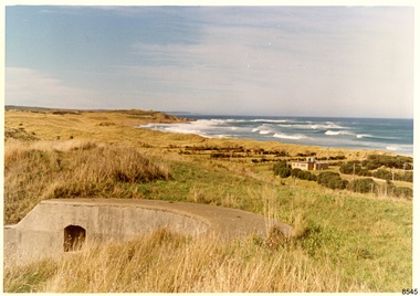
Photograph - Historical, Flagstaff Hill, Warrnambool Garrison Fortifications looking towards the Moyjil (Point Ritchie), 1970s
The photograph shows the location of the concrete, horseshoe shaped gun emplacement erected for the cannons. It is part of the Historic Precinct on Flagstaff Hill. The area was accessed either through the space between the Lighthouses (through the cottage grounds) or a service entrance, past the iron huts used by the Lands Department. This photograph, a print, is one of a set of five that show the site of Flagstaff Hill. It is presumed to have been taken by John Lindsay, Founding Director of Flagstaff Hill Maritime Museum and Village. One of the photographs in the set has the pencil inscription "Photo J Lindsay". It was taken in the early 1970s during the initial stages of the development of Flagstaff Hill as a Museum and Maritime Village. The photographs belonged to the donor's grandparents, who lived in the Warrnambool district of Allansford/Naringal. The photograph is a record of the site and surrounds of Flagstaff Hill Maritime Museum and Village before its development and opening in 1975. It shows the east side of the Surfside Holiday Park in its earlier days. The photograph is significant for recording the location and condition of the original concrete cannon emplacement on the Hill.Coloured photograph, glassy print, one of a set of five. Photograph shows the original site of one of the gun emplacements for the cannons, cannons Historical, looking towards the Moyjil, ,Point Ritchie and overlooking Lady Bay, Warrnambool. The horseshoe shaped concrete gun emplacement is in the foreground on the grassed slopes overlooking the Bay. The site and ablution block of the Surfside Holiday Park is centre right. The left shows the sore of Lady Bay with the cliffs of the Southern Ocean in the distance. The photograph's paper has the printer's watermark on the back. The early 1970s scene is presumed to have been photographed by John Lindsay, Warrnambool.Label on the back: "FIRST GUN EMPLACEMENT LOOKING TOWARDS THE HOPKINS / This is the original site of one of the cannons overlooking the Bay. Access to this area could be between the light-houses (throught the cottage grounds), or a service entrance - past the iron huts used by Lands Department."flagstaff hill, flagstaff hill maritime museum and village, warrnambool, maritime museum, maritime village, great ocean road, shipwreck coast, 1970s, photograph, gun emplacement, surfside holiday park, lady bay, hopkins river, flagstaff hill site, john lindsay, concrete gun emplacement, cannon emplacement, original emplacement -
 Flagstaff Hill Maritime Museum and Village
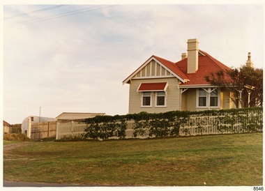
Photograph - Historical, Flagstaff Hill, Harbourmaster’s Quarters, 1970s
The photograph shows a cottage, Harbourmaster’s quarters that still stands on the east of the Lady Bay Lighthouse and Historic Precinct at Flagstaff Hill in Warrnambool. The name was changed to the Lighthouse Lodge, and today guests can stay at the property. This photograph, a print, is one of a set of five that show the site of Flagstaff Hill. It is presumed to have been taken by John Lindsay, Founding Director of Flagstaff Hill Maritime Museum and Village. One of the photographs in the set has the pencil inscription "Photo J Lindsay". It was taken in the early 1970s during the initial stages of the development of Flagstaff Hill as a Museum and Maritime Village. The photographs belonged to the donor's grandparents, who lived in the Warrnambool district of Allansford/Naringal. The photograph is a record of the site and surrounds of Flagstaff Hill Maritime Museum and Village before its development and opening in 1975. It shows the cottage on the east of the Lighthouse Complex,. The building is now known as Lighthouse Lodge. The photograph is significant for recording the location and condition of the residence on the Hill.Coloured photograph, glassy print, one of a set of five. Photograph shows the cream timber cottage, Harbourmaster’s quarters to the east of the lighthouse complex at Flagstaff Hill, Warrnambool. On the left of the red roofed residence are iron buildings used, at the time, by the Lands Department. The photograph's paper has the printer's watermark on the back. The early 1970s photograph is presumed to have been by John Lindsay, Warrnambool.Label on the back: "WOODEN RESIDENCE TO THE EAST OF THE PROPERTY / The gun emplacements are immediately behind, and the iron huts to the left rear of the residence are used by the Lands Department who plan to vacate, for other premises."flagstaff hill, flagstaff hill maritime museum and village, warrnambool, maritime museum, maritime village, great ocean road, shipwreck coast, 1970s, photograph, flagstaff hill site, john lindsay, cannon emplacement, residence, wooden residence, timber residence, iron huts, lands department -
 Flagstaff Hill Maritime Museum and Village
Photograph - Historical, building, Late 19th to early 20th century
The black and white photograph depicts the Lady Bay Lighthouse Complex at Flagstaff Hill, Warrnambool. It was opened on this site in 1871. From left to right, the Chartroom (previously named the Store), Upper Lighthouse, Flagstaff, Lighthouse Keeper's Quarters. The bluestone buildings are facing North on Merri Street. The Harbour Pilot's Lodgings were on the east of the Complex. There are two unknown male figures standing in front of the light-coloured picket fence that encompasses the Complex. The photograph is mounted on card. WARRNAMBOOL'S LADY BAY LIGHTHOUSES In the 1800s ships sailing from England to Australia began to use Bass Strait as a faster route to Melbourne. Small navigation errors led to many tragic shipwrecks. From 1848 lighthouses were operating along Victoria’s southern coast as a guide for sailors. Coastal towns such as Warrnambool grew and the exchange of trade and passengers was of great benefit. However, the uncertain weather changes, relatively shallow waters and treacherous, hidden rocky reefs were not really suitable for a Harbour and in the 1840s and 1850s, there were many shipwrecks in the area, with some even stranded in its Lady Bay harbour. A jetty was built in 1850 and a flagstaff to guide seafarers was placed up high on what became known now as Flagstaff Hill. In November 1857 the Victorian Government recommended that Warrnambool Harbour had beacons and two lighthouses to guide vessels into and out of the Harbour safely. The white light of the Middle Island lighthouse was to be used for the first time on September 1, 1859. The red light of the Beach Lighthouse, a wooden obelisk structure, was first operated on March 25, 1860, but in 1868 this light was ‘discontinued’ due to it being too low. Melbourne’s Department of Public Works decided to relocate the Middle Island Lighthouse Complex - Lighthouse, Keeper’s Quarters, Privy, Store Room and even water tanks - to Flagstaff Hill. The lower obelisk was shortened, and a protruding gallery, railing, and external ladder were added, and the light from the Beach Lighthouse. A green guiding light was erected on the end of the jetty. The transfer of the Complex began in March 1871. Each shaped stone of the lighthouse was carefully numbered, removed then reassembled on Flagstaff Hill. In 1872 the well was sunk behind the Lighthouse Keeper’s Cottage. The Keepers and families had left Middle Island in April and moved to Flagstaff Hill in October 1871. Vessels entering Lady Bay align the Upper and Lower Lighthouse towers during the day and the lights at night. The Upper Lighthouse is a round tower, and the Lower Light is square. The Lighthouses were categorised as harbour lights rather than coastal lights, so they remain under the control of the Victorian Government’s Ports and Harbours section. The lights were originally powered by oil, then acetylene gas, later by electricity, and then converted to solar power in 1988. In 1993 the solar panel was replaced by a battery charger. A decision was made in 1936 to replace the lighthouses’ lights with unattended lights that no longer required Keepers and Assistants. At least 29 Keepers had attended to the lighthouse from its opening in 1859 to when the last official Lightkeepers left In April 1916. The Warrnambool Harbour Board rented out the Quarters from 1916 to 1936. The Board closed down but the rentals continued with other unknown landlords. In the 1970s the Flagstaff Hill Planning Board was set up under the chairmanship of John Lindsay. The Board was to make recommendations to the Warrnambool City Council regarding using the buildings and the rest of the Crown Land on the site. The Flagstaff Hill Maritime Village opened in 1975 and began renovating the Cottage in stages, during which time evidence of a 1920s fire was found in the eastern section of the cottage. Additions of a porch on the west and a washroom on the east were made in the 1980s. The western part of the building is now a Shipwreck Museum and the east has returned to a late 19th-century Lighthouse Keeper’s cottage and includes the screen made by Assistant Lighthouse Keeper Thomas Hope in the late 19th century. He served as Assistant Keeper in Warrnambool for two periods.The Warrnambool Lighthouse Complex is now listed on the Victorian Heritage Register, H1520, for being of historical, scientific (technological) and architectural significance to the State of Victoria. The Complex is significant as an example of early colonial development. The buildings are significant for their connection with the important navigational function of the Lighthouses, a function still being performed to this day. The buildings are also significant as an example of structures designed and works carried out by the Public Works Department in Victoria in the mid-to-late 19th century. The structures still stand strong. Photograph; Warrnambool Lighthouse Keeper's cottage, lighthouse, flagstaff and chartroom at Flagstaff Hill, and a light-coloured picket fence with gate. Two male figures are in front of the fence. Black and white print glued to a yellow card. The inscription is indecipherable. The right side of the cottage has a built-in, enclosed addition.Ink stamped in lower right hand corner, too faded to be legible.flagstaff hill, flagstaff hill maritime museum, flagstaff hill maritime village, warrnambool, maritime museum, shipwreck coast, lighthouse keeper's cottage, lighthouse residence, lighthouse, chart room, quarters, privy, middle island, beach lighthouse, obelisk, lighthouse complex, lady bay complex, warrnambool port, warrnambool harbour, lady bay, keepers, lighthouse keeper, upper lighthouse, lower lighthouse, assistant keeper, ports and harbours, cottage -
Lakes Entrance Historical Society
Book, Da Costa, Grant, Car Touring and Bush Walking in East Gippsland, 1988
Comprehensive guide to the magnificent forests and coastal areas of East Gippsland, Victoria, including twenty seven maps and notes on seventeen car tours, fifty nine locations of outstanding impact and 45 bushwalks. Illustrated with coloured photographicnatural history, vegetation, coast