Showing 1947 items matching "floods"
-
 Lakes Entrance Historical Society
Book, L V Printers, Red Alert, 2007
A pictorial record of the 2006/2007 Gippsland FiresRed covered paperback with 24 pagesnon-fictionA pictorial record of the 2006/2007 Gippsland Firesfires, disasters, fundraising -
 Bendigo Historical Society Inc.
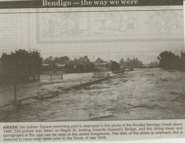
Newspaper - JENNY FOLEY COLLECTION: AWASH
Bendigo Advertiser ''The way we were'' from 2000. Awash: the Golden Square swimming pool is swamped in this photo of the flooded Bendigo Creek about 1949. The picture was taken on Maple St. looking towards Howard's Bridge, and the diving tower and springboard at the pool can be seen in the centre foreground. The date of the photo is unknown, but is believed to have been taken prior to the floods of late 1949. The clip is in a folder.newspaper, bendigo advertiser, the way we were -
Whitehorse Historical Society Inc.
Correspondence, Documents re P.E. Eriksson property purchase, 1/03/1943
Invoice and receipt - property search for Mrs P.E. Eriksson from Flood & Permezel solicitors, Collins Street. Receipt for deposit from Frank Parker, Real Estate Agent. Title check and plan from Flood & Permezel. Copy, contract of sale - Insurance Policy Coop Insurance Co. Invoice Griffiths Bros, tea merchants Nov 1910 - Jan 1911 for Mrs A. Eriksson. Advice - certificate of title.eriksson, pearl eileen, w. h. flood & permezel, frank parker (real estate agent), warnes road, mitcham no 30, land sales, cooperative insurance company of australia, edgar -
 Ballarat Tramway Museum
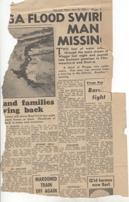
Newspaper, Herald Sun, "Barwon fight", 19/06/1952 12:00:00 AM
Newspaper Clipping from the Melbourne "The Sun", dated 19/6/1952 about widespread flooding in Victoria and Wagga and on the right hand side of the clipping the Barwon River Geelong titled "Barwon fight". Notes the flooding over the Barwon River which caused suspension of the tram services. Contained originally within Reg Item 5623 at the front of this note book. For items see btm5623 loose items list.pdf.geelong, flooding -
Clunes Museum
Photograph
.1 17 PHOTOGRAPHS OF CENTENARY/BACK TO CLUNES 1939 .2 PHOTOGRAPH OF SCHOOL, BAILEY STREET .3 KODAK ENVELOPE FOR PHOTOGRAPHS .4 4 PHOTOGRAPHS OF CREEK IN FLOOD.3 WRITING ON COVER RED ON BLACK: HAPPY SNAPSback to clunes, centenary 1939 -
 Bendigo Historical Society Inc.
Newspaper - LYDIA CHANCELLOR COLLECTION: BENDIGO COMMUNITY
A decorated box containing cuttings from 'The Bendigo Advertiser' of life in Bendigo between 1961 and 1965. Includes weddings, floods, shire and council events, church activities etc.bendigo, history, community activities, lydia chancellor, collection, bendigo, male, female, people, community, people, place, clubs and associations, individual, entertainment -
 Sunbury Family History and Heritage Society Inc.
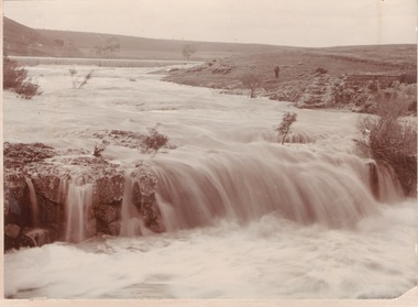
Photograph
The waterfalls were on the Jacksons Creek downstream from Sunbury township and in the vicinity of a mill which was built on the river bank. The man standing on the riverbank on the RHS of the image is near the remains of Eadie's Mill which was one of the early structures erected in Sunbury.A sepia photograph mounted on a cream board of two waterfalls in a flooded river with bare hills on either side. A man is standing near some stone ruins on the RHS of the image.waterfalls, jacksons creek, mill falls -
 Charlton Golden Grains Museum Inc
Photograph, 1973 Flood High Street Charlton
B/W photograph of 1973 flood. Taken in front of Harold Baird's residence. Shows water up High Street to Kaye Street Charlton. Unframed Photograph/Sepiaflood, charlton -
 Greensborough Historical Society
Photograph - Photograph - Digital Image, Marilyn Smith, Plenty River high water 2020, 24/08/2020
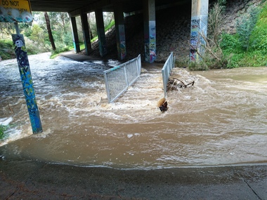
... floods ...Digital images of high water in the Plenty River at Greensborough 24/08/2020. Part of a collection of miscellaneous historical images with a connection to the local area.7 Digital colour photographs of the Plenty River. plenty river, floods -
 Greensborough Historical Society
Photograph - Photograph - Digital Image, Marilyn Smith, Plenty River high water 2020, 24/08/2020
... floods ...Digital images high water in the Plenty River at Greensborough 24/08/2020. Part of a collection of miscellaneous historical images with a connection to the local area.7 Digital colour photographs of the Plenty River. plenty river, floods -
 Merbein District Historical Society
Photograph, Vineyards surrounding Merbein Pumps, unknown
... Floods ...blocks, floods -
Merbein District Historical Society
Photograph, River Road 1956 flood, 1956
... Floods ...floods, murray river flood 1956 -
 Charlton Golden Grains Museum Inc
Photograph, c.August 1909
Floods 1909, High Street, Charlton. The flooding occurred in August 1909.Black and white photo, not mounted and with no boarder.flood, charlton, business, high street -
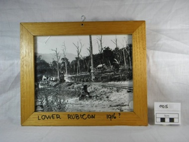 Alexandra Timber Tramway & Museum
Framed black and white photograph, Untitled, Rails to Rubicon circa 1916, 1/1/1985 (estimated)
... floods ...We have not statement of significanceWooden framed black and white photograph of a two foot gauge steel rail line from the mill sight to Alexandra. This locomotive, a Kraus, steam engine (year ?)is passing through Lower Rubicon. It hauls three carriages with timber and on the side of the rail there are open boxes. A wooden house on Gilmore's family property is halfway up the hill. The property shows signs of damage of the recent Goulburn River flooding in 1916. There is a hook in the top of the frame and writing on the bottom of the frame "Lower Rubicon 1916".On bottom of the frame "Lower Rubicon 1916?" written with black texta colour pen in capital letters. 1916, cottage, rail, locomotive, train, floods, dead trees, two foot gauge, timber stacks, goulburn river floods, gilmore, lower rubicon, carriages, rubicon, kraus -
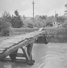
 Eltham District Historical Society Inc
Album - Photograph, J.A. McDonald, Eltham-Greensborough Road, 18 Oct. 1956
... floods ...Bridge Street Bridge Flooding on Waterfall’s Estate 18th October 1956 Looking east up to Main Road over what is now present-day Alistair Knox Park Beware!.. our rivers are rising (1956, October 19). The Argus (Melbourne, Vic. : 1848 - 1957), p. 1. Retrieved August 24, 2022, from http://nla.gov.au/nla.news-article84392304Record of various Shire of Eltham infrastructure works undertaken during the period of 1952-1962 involving bridge and road reconstruction projects, sometimes with Eltham Shire Council Project Reference numbers quoted. It was during this period that a number of significant improvements were made to roads and new bridges constructed within the shire that remain in place as of present day (2022). In many situations, the photos provide a tangible visible record of infrastructure that existed throughout the early days of the Shire. The album was put together by or under the direction of the Shire Engineer, J.A. McDonald.infrastructure, road construction, shire of eltham, bridge construction, bridge street bridge, eltham, eltham-greensborough road, 1956-10-18, diamond creek (creek), floods, floodwater, silver street bridge, alistair knox park, waterfall property -
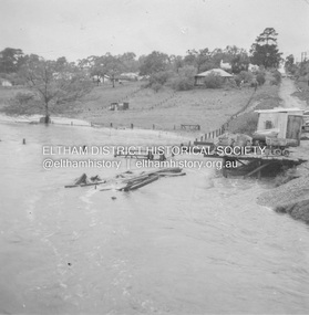
 Eltham District Historical Society Inc
Album - Photograph, J.A. McDonald, Eltham-Greensborough Road, 18 Oct. 1956
... floods ...Bridge Street Bridge Flood level on Greensborough pier 18th October 1956 View looking west across the Diamond Creek and tempoary walking access bridge towards intersection of Susan Street. The building visible on centreeline is the present-day SES facility. Beware!.. our rivers are rising (1956, October 19). The Argus (Melbourne, Vic. : 1848 - 1957), p. 1. Retrieved August 24, 2022, from http://nla.gov.au/nla.news-article84392304Record of various Shire of Eltham infrastructure works undertaken during the period of 1952-1962 involving bridge and road reconstruction projects, sometimes with Eltham Shire Council Project Reference numbers quoted. It was during this period that a number of significant improvements were made to roads and new bridges constructed within the shire that remain in place as of present day (2022). In many situations, the photos provide a tangible visible record of infrastructure that existed throughout the early days of the Shire. The album was put together by or under the direction of the Shire Engineer, J.A. McDonald.infrastructure, road construction, shire of eltham, bridge construction, bridge street bridge, eltham, eltham-greensborough road, 1956-10-18, diamond creek (creek), floods, floodwater, silver street bridge -
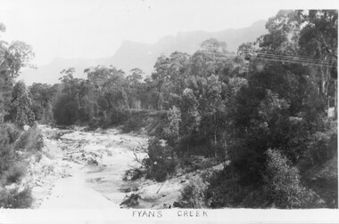 Halls Gap & Grampians Historical Society
Photograph - B/W
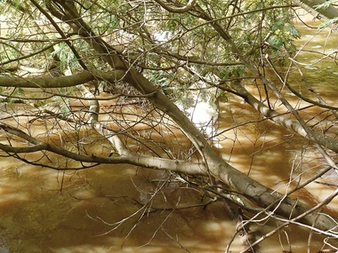
Photo shows Fyans Creek, looking South West towards the Pinnacle. View probably taken from the bridge. Fyans Creek appears to be very wide, perhaps after a flood.scenery, fyans creek -
Port Melbourne Historical & Preservation Society
Plan - Proposed bridge under Hobsons Bay railway at Clarendon Street, Emerald Hill, 1854 - 1884
Plan of proposed bridge under Hobson's Bay Railway at Clarendon Street, Emerald Hill, affecting Sandridge railway and Sandridge Road. Flood level re Sandridge line is shown.transport - railways, flood, emerald hill, town planning -
Clunes Museum
Photograph
3 X COLOUR PHOTOGRAPHS TAKEN AT MT CAMERON ROAD BRIDGE OF THE FLOODS OF AUGUST TO SEPTEMBER 2010 PHOTOGRAPHS WERE TAKEN ON 12/08/2010 AND 04/09/2010STICKER ON THE BACK OF PHOTOGRAPH: MC. EILEEN BRADSWORTH, CLUNESflood 2010, mt cameron road bridge -
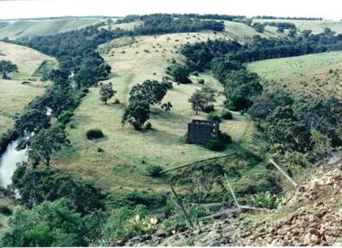 Hume City Civic Collection
Photograph
Lochton Flour Mill was established in the 1850s and is only one of a few surviving mills in Victoria. It is situated on a horseshoe bend on the Deep Creek at Bulla.A coloured photograph of a horse shoe bend in a river and the open flood plain. The river is tree-lined. The ruins of a stone building are on the river bend. A damaged fence and prickly pears are in the foreground.lochton mill, deep creek, hunter, william morrison, george evans collection -
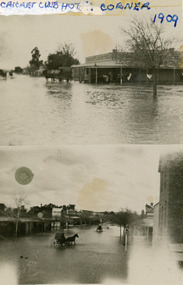 Charlton Golden Grains Museum Inc
Photograph, August c.1909
1909 Flood - Cricket Club cnr and High Street. The flood occurred in August of 1909 Black and White double photo. The top half shows the Cricket Hotel the bottom half shows a view down High Street Charltoncricket cub hotel, 1909 flood, flood, charlton, business -
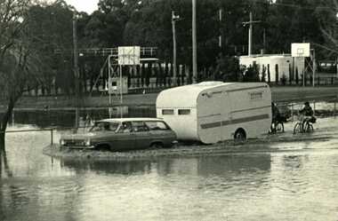 Charlton Golden Grains Museum Inc
Photograph - B/W Photograph of 1973 flood near Gordon Park, 1973 Flood, c. Feb 1973
1973 flood near Gordon Park, Car and caravan driving through flood water and road followed by two bicycles. Campers forced out of Gordon Park by rising flood waters c.1973Unframed B/W photograph flood, gordon park, charlton -
University of Melbourne, Burnley Campus Archives
Plan, Royal Horticultural Society's Garden
Changed boundaries of the site burnley gardens, survey paddock, flood, lynch design, richmond park, yarra river -
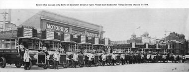 Melbourne Tram Museum
Photograph - Illustration, James Flood Charity Trust, c1914
Illustration from a photograph of 10 Tilling Stevens double deck buses operated by the Motorbus Services Limited. Have various destination of St Kilda Beach via Swanston St, St Kilda Rd Fitzroy St Esplanade. On the side of the bus is an advertisement for "Abbotsford Ale". From the James Flood Book as it notes that James Flood built 10 bodies during 1914 for the company. Photographed in Swanston St with the City Baths in the background.trams, tramways, melbourne, swanston st, buses, tilling stevens, private bus companies -
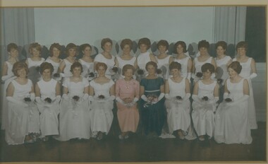 Bendigo Historical Society Inc.
Photograph - MAYORAL DEBUTANTE BALL, 1966-1967
Mayoral Debutante Ball 1960's, colour group photograph of Debutantes seated with Mayoress Mrs Tom Flood, under glass in a white timber frame with gold moulding. Deframed 2022Martin Washingtonphotograph, portrait, female group -
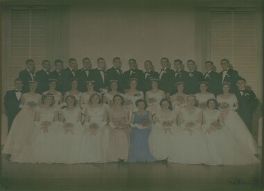 Bendigo Historical Society Inc.
Photograph - MAYORAL DEBUTANTE BALL, 1957-1958
Hand tinted photograph of Debutante Ball in 1950's showing group of Debutantes and partners with Mayoress Mrs Tom Flood, under glass with blond wood timber frame. Deframed 2022Reg Brockphotograph, portrait, group -
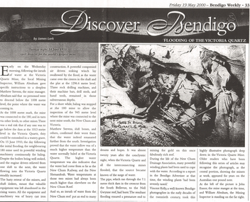 Bendigo Historical Society Inc.
Newspaper - LONG GULLY HISTORY GROUP COLLECTION: FLOODING OF THE VICTORIA QUARTZ
Copy of an article from the Bendigo Weekly 19/5/2000 Discover Bendigo - Flooding of the Victoria Quartz by James Lerk. Article mentions the flooding of the mine, the equipment left in there and where the water had come from. An accompanying photo, taken by Vincent Kelly, shows miners at work underground. John Ennor, the mine manager at the time and William Abraham, the Mining Inspector are in the photo. Written on the photo is: 4156 ft below Vic Quartz G Mine.bendigo, history, long gully history group, the long gully history group - flooding of the victoria quartz, bendigo weekly 19/5/2000, james lerk, william abraham, matthew stevens, 180 mine, new chum and victoria, new chum railway, new shenandoah, new chum reef, south bellevue, nell gwynne reef, new chum drainage association, bendigo advertiser, vincent kelly, john ennor -
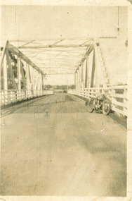 Lakes Entrance Historical Society
Photograph - Bridges, 1940
After 1934 flood damage to second bridge, centre pile was replaced by a truss girder, this survived until 1971 floodBlack and white photograph showing second Orbost Bridge over the Snowy River, wooden planks, railing and overhead support. Motor bike leaning on railing at near end of bridge. Orbost, Victoria.bridges, waterways -
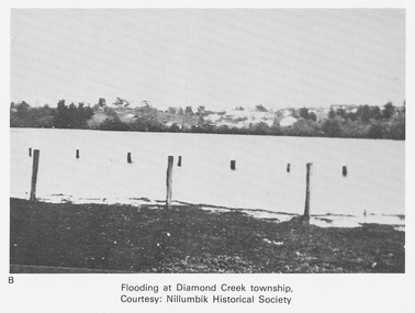 Eltham District Historical Society Inc
Work on paper (Sub-Item) - Photograph, Flooding at Diamond Creek Township
Black and white photograph of the Diamond Creek in flood at Diamond Creek township in 1934. In 1934 extensive flooding of the Yarra River and Diamond Creek set new records for flood plain level (Eltham Chronology EDHS) Nillumbik Historical Society collectionflood, diamond creek, flooding, nillumbik historical society -
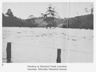 Eltham District Historical Society Inc
Work on paper (Sub-Item) - Photograph, Flooding at Diamond Creek Township
Black and white photograph of the Diamond Creek in flood at Diamond Creek township in 1934. In 1934 extensive flooding of the Yarra River and Diamond Creek set new records for flood plain level (Eltham Chronology EDHS) Nillumbik Historical Society collectionflood, diamond creek, flooding, nillumbik historical society