Showing 11903 items
matching geo-map
-
 Melbourne Tram Museum
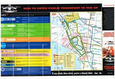
Map, Yarra Trams, "Circuit Map & Transport Guide 2007", Mar. 2007
Fold out map, full colour printed on gloss paper - 8 x 2 folds. showing location of the race track, how tram and rail routes operated, restricted parking area, Metcard, where taxis and limousines could park, bicycle racks. On the reverse side has a detailed map of Albert Park showing the various race facilities and grandstands. Used for the 2007 Grand Prix. See Reg Item 1063 for associated booklet. Item contained with in a plastic envelope with a black neck band. 2 copies held. 1064.1 - similar map for the March 2004 event - see image i3. Added 11-3-2018 from donation of Hugh Waldron.trams, tramways, grand prix, metlink, formula 1, albert park, maps -
 4th/19th Prince of Wales's Light Horse Regiment Unit History Room
Booklet, Manual of Map Reading, Air Photo Reading & Field Sketching Part 2 Air Photo Reading
A yellow dust jacketed hard covered booklet enabling officers and NCO to make use of air photographs to support the map, and support ground recon and to use when ground recon is not possibleWO Code No 9484air photo reading -
 Ballarat Tramway Museum
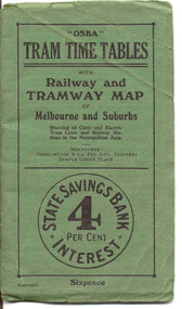
Ephemera - Timetable/s, Osboldstone & Co Pty Ltd and Printers and Publishers Melbourne, "OSBA Tram Time Tables with Railway and Tramway Map, of Melbourne and Suburbs", 1920's
Yields information about the tram timetables applicable to Melbourne's trams, including cable and electric and demonstrates the spread of Melbourne's public transport system in the early 1920's.Forty Eight page printed book contained with oversize green heavy paper covers centre stapled with a coloured map glued into the rear cover of the book titled "OSBA Tram Time Tables with Railway and Tramway Map, of Melbourne and Suburbs". Published c1920 - shows Footscray system, Victoria St Flemington link, does not show Puckle St. Timetables details Fares, first and last cars for cable and electric lines, sections and other details of the various lines. Note page 44 and 45 cannot be accessed, paper not cut correctly during the printing process - leave as is. Map prepared by Gawler and Drummond Architects, shows in colour the cable routes, electric tramways, authorised tramways and railway lines. Municipalities shown in different colours. Map folded into 12 sections. Published by Osboldstone & Co Pty Ltd, Printers and Publishers, Temple Court Place, Melbourne. Price 6d. Full scan of document added as a pdf file 5/6/2019. map, timetables, melbourne, cable trams -
 Bendigo Historical Society Inc.
Document - GEORGE MEAKIN COLLECTION: TAILOR'S MEASUREMENT AND ORDER BOOK, Sep. 1912 to May 1913
Document : Part of a lined exercise book in poor condition. Entries hand written in pencil by date and name. Measurements for Masonic clothing? Geo. Meakin, tailor.Geo. Meakin, tailor, High St Bendigoorganization, retail, tailor, geo. meakin, tailor, clothing measurements, masonic lodge -
 Ballan Shire Historical Society
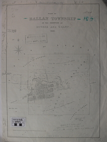
Map - Map. Ballan Township, Plan of Ballan Township in the Counties of Bourke and Grant
The map is an early one of the township of Ballan showing street names and land owners.The map is significant in that it lists the owners of the house blocks within the township.A map showing the township and surrounding area of Ballan in 1856. Town streets are named as are the owners of the subdivided blocks of land. The map is a lithocopy and there is a scale in chains."D D Fraser" is written across the top of the map and "1856" is written in the near top right corner. There are other additions to the map but they are very difficult to decipher accurately or completely.ballan, ballan township map, ballan1856 -
 Bendigo Military Museum
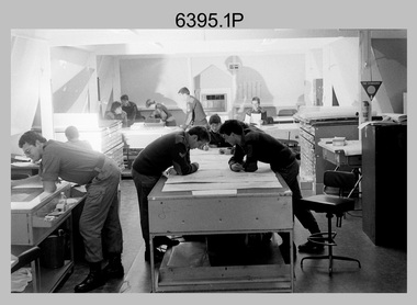
Photograph - Army Survey Regiment – Map Production, Fortuna, Bendigo, 1986
These 17 photographs of the Army Survey Regiment’s map production and facilities were taken at Fortuna Villa, Bendigo, April 1986. Photos .1P to .3P were taken in Cartographic Squadron’s Correcting Section in the Attic. located on the top floor of Fortuna Photos .4P to .5P were taken in Cartographic Squadron’s Proving Section, located in the Ballroom also on the top floor facing the lake. The technicians were probably involved in a rapid response map production, as they all were wearing field uniforms. As ‘Regiment Overcrowding’ is annotated on the plastic sleeve holding the negatives, it seems the photos were taken when the unit was at its capacity to demonstrate the lack of suitable work areas. The Army Survey Regiment’s Duty Room, RAP and Carpark appearing in Photo .10P was probably taken from the top steps near the SGT’s accommodation block. Two of the photos in this set are also published in item 6096.5P.This is a set of 17 photograph of Map Production and car park was taken at the Army Survey Regiment, Fortuna, Bendigo, in April 1986. The black & white photographs are on 35mm negative film and are part of the Army Survey Regiment’s Collection. The photographs were scanned at 96 dpi. .1) - Photo, black & white, 1986. Correcting Section, Attic: L to R: CPL Andy Lucas, SPR Chris Gordon, unidentified, SPR Jan (Crighton) Minchin, CPL Robin Marshall, CPL Frank Downie, SPR Gayle Humphrey, unidentified (x2), Jason Wells at rear. .2) - Photo, black & white, 1986. Correcting Section, Attic: L to R: CPL Andy Lucas, SPR Chris Gordon, unidentified, SPR Jan (Crighton) Minchin, CPL Robin Marshall, CPL Frank Downie, SPR Gayle Humphrey, unidentified, Jason Wells, unidentified. .3) - Photo, black & white, 1986. Correcting Section, Attic: L to R: CPL Andy Lucas, CPL Robin Marshall, SPR Chris Gordon, unidentified, CPL Frank Downie, SPR Gayle Humphrey, unidentified, SPR Jan (Crighton) Minchin at rear., Jason Wells on phone. .4) & .5) - Photo, black & white, 1986. Proving Section, Ballroom: On left front to back: SGT Alan Staley, SGT Roger Rees, SGT Greg Anderson. On right front to back: SGT Denis McCarthy, SGT Tim Allanson, SSGT Adrian ‘Charlie’ Creedy. .6) - Photo, black & white, 1986. Records & Proofing buildings. .7) - Photo, black & white, 1986. Technical Services temporary buildings. .8) - Photo, black & white, 1986. Q-store and transport buildings. .9) - Photo, black & white, 1986. Technical Services temporary buildings in front of transport compound. .10) - Photo, black & white, 1986. Army Survey Regiment Duty Room, RAP and Carpark at Fortuna. .11) - Photo, black & white, 1986. Records & Proofing buildings. .12) - Photo, black & white, 1986. Other Ranks (OR’s) car park and barracks with kitchen in background. .13) - Photo, black & white, 1986. Other Ranks kitchen, parade ground and SGT’s/Officers barracks in background. .14) - Photo, black & white, 1986. Fortuna Villa taken from the steps near the SGT’s accommodation block. .15) - Photo, black & white, 1986. Fortuna Villa taken from the steps near the OR’s s accommodation block. .16) - Photo, black & white, 1986. Fortuna Villa taken from the roadway near the OR’s accommodation block. .17) - Photo, black & white, 1986. 20’ x 30’ Army tents set up on the basketball court..1P to .17P – ‘Regiment Overcrowding’ and the date are annotated on the plastic sleeve.royal australian survey corps, rasvy, army survey regiment, army svy regt, fortuna, asr -
 Melbourne Tram Museum
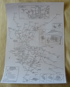
Poster, P. Sohns, "Melbourne Tram Track map (June 2006)", 2006
Poster - titled "Melbourne Tram Track map (June 2006)", line drawing on white paper, showing a detailed track map of junctions, depots, cross overs, route numbers, Preston Workshop, track out of service but overhead still in place, routes under construction of planning. Prepared by P. Sohns with Research by H. Waldron. Dated 8/4/2006. Has a detailed inserted of the city area. One unlaminated and one laminated copy held.trams, tramways, melbourne, map, tramways, depots, workshops, tram routes -
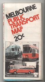
 Melbourne Tram Museum
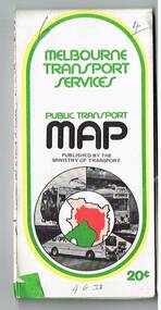
Map, Ministry of Transport, "Melbourne Transport Services Map - Tram, Train and Bus Services", 1975-1976
Fold out map (27 sections 9 across x 3 deep), coloured of Melbourne's Tram and Bus routes, route numbers, rail lines, detailed for the central part of Melbourne and insert section for Frankston. On rear description of routes, private bus routes and map of Melbourne metro lines. Has contact details for bookings and lost property etc. Priced 20c possible 1975-1976 - has 1041 and silver train on front cover.On front cover in ink "3" in top right hand corner and "4 G 33 " along bottom edge.trams, tramways, melbourne, map, tram & bus services, railways, mmtb, minister for transport -
4th/19th Prince of Wales's Light Horse Regiment Unit History Room
Book, Modern Printing Co Pty Ltd, Manual of Map Reading, Photo Reading ing and Field Sketching1929, abt 1940
Soft covered book covering map reading, field sketching and air photo reading for use of Officer candidates, Officers and NCO's. Reprinted with amendments Nos 1 - 4, 1939. 2 copies26 manuals 412manual, map reading, air photo reading, field sketching -
4th/19th Prince of Wales's Light Horse Regiment Unit History Room
Book, Manual of Map Reading, Photo Reading ing and Field Sketching1929, abt 1940
Hard covered book covering map reading, field sketching and air photo reading for use of Officer candidates, Officers and Non-commissioned Officers. Reprinted with amdts Nos 1 - 4 193926 Manuals 412manual, map reading, air photo interpretation, field sketching -
Whitehorse Historical Society Inc.
Map, before 1890
Early map showing location and areas of plots and their owners' names between Heatherdale Road in the east and Springvale Road in the west, Burwood Road to the south to north of Canterbury Road. Later additions to 1969Early map showing location and areas of plots and their owners' names between Heatherdale Road in the east and Springvale Road in the west, Burwood Road to the south to north of Canterbury Road. Later additions to 1969Early map showing location and areas of plots and their owners' names between Heatherdale Road in the east and Springvale Road in the west, Burwood Road to the south to north of Canterbury Road. Later additions to 1969mitcham, vermont, nunawading -
Ringwood and District Historical Society
Map, Ringwood Croydon Mail, Map of East Ringwood with numbered sites of interest published by the Ringwood Croydon Mail for Ringwood Secondary College Fire Appeal Fund. 1993, 16-Sep-93
Map of East Ringwood with numbered sites of interest published by the Ringwood Croydon Mail as the major sponsor for Ringwood Secondary College Fire Appeal Fund. The school was extensively burnt in a fire in 1992 which destroyed classrooms, records, musical and sports displays.White sheet of paper with brown printing, A3, with marked locations for visiting. -
Clunes Museum
Map, A.C. BROOKS GOVERNMENT PRINTER MELBOURNE, EGLINTON COUNTY OF TALBOT, 1965
MAP OF EGLINTONMAP OF EGLINTON, COUNTY OF TALBOT PRINTED ON CANVAS WITH PLASTIC TAB FOR HANGING. MAP SHOWS TOWN ALLOTMENTSADMINISTRATIVE STAMP ON BOTTOM LEFT AND ON THE BACK OF THE MAP ANOTHER STAMP - NORTHERN DIVISION (299) FORESTS COMMISSION BENDIGOeglinton, historical map -
 Melbourne Tram Museum
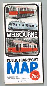
Map, Ministry of Transport, "Melbourne Transport Services Map - Tram, Train and Bus Services", 1976
Fold out map (27 sections 9 across x 3 deep), coloured of Melbourne's Tram and Bus routes, route numbers, rail lines, detailed for the central part of Melbourne and insert section for Frankston. On rear description of routes, private bus routes and map of Melbourne metro lines. Has contact details for bookings and lost property etc. Priced 20c Has a bus, silver train and a Z class tram on the cover. On bottom of outside cover, "No. 5 1976"On front cover in ink "5" in top right hand corner and "4 G 33 " along bottom edge.trams, tramways, melbourne, map, tram & bus services, railways, mmtb, minister for transport -
4th/19th Prince of Wales's Light Horse Regiment Unit History Room
Book, Manual of Map Reading, Photo Reading and Field Sketching 1929, 1948
Hard cardboard covered book, covering map reading, field sketching and air photo reading for use of officer candidates, officers and non-commissioned officers. Reprinted with amendments Nos 1 -4, 193926 GS Pubns 124manual, map reading, air photo interpretation, field sketching -
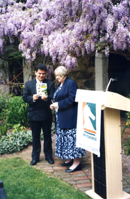 Whitehorse Historical Society Inc.
Photograph, Launch of Valley of the Arts Tourist Map, 1/10/2000 12:00:00 AM
Coloured photo of Minister for Tourism, John Pandazopoulos and Mayor of City of Whitehorse, Cr, Jessie MacCallum at launch of Co-operative venture Valley of the Arts Tourist Map at Schwerkolt Cottage on 6th October 2000.pandazopoulos, john, maccallum. jessie, city of whitehorse, valley of the arts, schwerkolt cottage. -
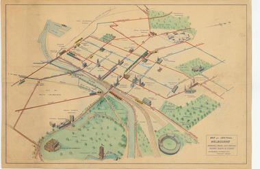 Melbourne Tram Museum
Map, Melbourne & Metropolitan Tramways Board (MMTB), "Map of Central Melbourne", c1952
Map - dyeline print then hand coloured, titled "Map of Central Melbourne", subtitled "Showing tram and bus routes, railways, places of interest:. Includes railway yards. gardens, trams routes shown in direction in some places. Has initials WKGP in bottom right hand corner. Map c1952, after the Latrobe St lines opened but before Bourke St lines opened. Note: 1 - The Hanna St or South Melbourne depot is shown south of City Road, not south of Sturt Street as it should have been. 2 - route 78 shown terminating at Batman Ave is incorrect, ran from Victoria and Church Sts. Original document scanned as a high res tiff file, approx. 60MB, see large files directory - htd3736-large.tiftrams, tramways, mmtb, map, melbourne, tram routes, south melbourne depot, hanna st depot, latrobe st, la trobe st -
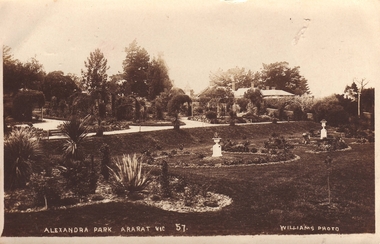 Clunes Museum
Postcard - POSTCARD ARARAT PARK, REAL PHOTOGRAPH, BY T.R. WILLIAMS ARARAT
POSTCARD SENT TO TOT TREMBATH FROM GEO. HALLPOSTCARD SENT FROM NHILL, VICTORIA, DATED 8. AUG. NO STAMP OR POST OFFICE DATE MESSAGE FROM GEO HALL TO TOT?ALEXANDRA PARK ARARAT VIC 57 WILLIAMS PHOTOtrembath, perry, ararat park -
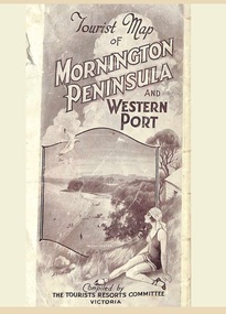 Ringwood and District Historical Society
Memorabilia, Tourist Map of Mornington Peninsula and Western Port - 1929
Multi-fold pictorial map of towns, railways and main roads east of Port Phillip Bay from Melbourne to Yarra Junction and south to Phillip Island and Wonthaggi, backed by details of main features and points of interest.Photo-Lithographed by Department of Lands and Survey, Melbourne, 2.8.1929. -
 Melbourne Tram Museum
Map, Ministry of Transport, "Melbourne Public Transport Map", c1977
Fold out map (27 sections 9 across x 3 deep), coloured of Melbourne's Tram and Bus routes, route numbers, rail lines, detailed for the central part of Melbourne and insert section for Frankston. On rear description of routes, private bus routes and map of Melbourne metro lines. Has contact details for bookings and lost property etc. Priced 20c Dated 1977, says No. 6 on bottom of rear cover. Note shows route 59 being cut back to the highway.trams, tramways, melbourne, map, tram & bus services, railways, mmtb, minister for transport -
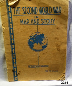 Bendigo Military Museum
Book - BOOK WW2, The Second World War in Map and Story, During the WW2
Covers are yellow/orange with all writing in blue. Title at top, globe depiction of the world central at bottom "An Argus Production, Price Two shillings. 63 pages of history with full page map every 2nd page.books, maps, story -
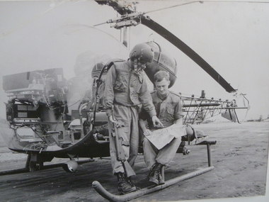 National Vietnam Veterans Museum (NVVM)
Photograph, Two 2nd Lieutenants And A Map, 1/08/1966 12:00:00 AM
Unframed photo of 2nd Lt Bob Rich and 2nd Lt Victor Salmon pilots from 161 Recon Flight check details on a map before their next mission. They are positioned next to a Bell Sioux 63B1 helicopterAWM FOR/66/0730/VNvictor salmon, bob rich, 161 reconnaissance flight, bell sioux 63b1, helicopter -
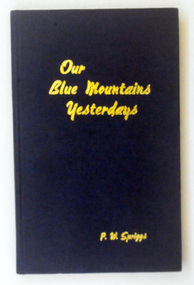 Orbost & District Historical Society
book, Geo. H. Gearside, Our Blue Mountains Yesterdays, July 1962
This is a useful reference tool.A hard back book with a dark blue cover. The title,"Our Blue Mountains Yesterdays P.W. Spriggs" is in gold print. It contains black/white photographs and the history of the blue Mountains of New South Wales.inside front cover - P.W.Spriggs Leura N.S.W. 1962 inside - "To Dear Casey from Athol & Thelma Charlesworth"blue-mountains-history -
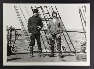 Mission to Seafarers Victoria
Photograph, Peckham Photographic Studios, Geo Beachcroft, Capt Dahlström and 2nd mate of the C.B. Pedersen, c. 1935
In the Sydney Morning Herald, Tuesday 27 April 1937, page 12: "The C. B. Pedersen was built in 1891. It has visited Australia several times, the most recent occasion having been in 1935, when It was anchored in Port Phillip Bay, Victoria, for several weeks, awaiting a suitable cargo. At length the master, (Captain Hjalmar Dahlström) announced that, as no cargo could be obtained he would be prepared to carry passengers in a voyage to Gothenburg, via Torres Strait. Eight persons, including three women and a small boy were accepted as passengers, and signed on as members of the crew at salaries of 1/ a month". Artist Violet Teague was one of the passengers. She painted during the voyage and exhibited her work in 1938. Built in 1891 the C.B Pedersen, a four-masted steel barque (2142 tons) was used as a training Barque. The ship foundered in April 1937, the crew was saved. Several photographs of the C.B. Pedersen taken by the same studio are held at the State Library of Victoria.see links aboveBlack and white photograph depicting two sailors in attire on the deck of a ship.verso in Black ink; Photographic studio stampcrew, c.b pedersen, captain hjalmar dahlström, violet teague, windjammer -
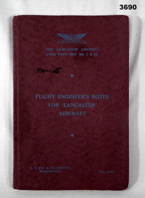 Bendigo Military Museum
Accessory - TRAINING MANUAL, Flight Engineer's Notes for 'Lancaster' Aircraft, 5.1943
Contains detailed diagrams of the Lancaster Bomber. Item re Frederick Gardner DAVEY DFC No 410533 RAAF. Refer Reg No 3536P for his service details.Maroon, soft card, cover. Pages bound & glued to cover. Title on front in light blue type, pages not numbered. 11 foldout black / white diagrams attached after the final printed page.Handwritten in black ink on left of front cover: PHILLIPS On title page details of the holder in black ink: K.T. COOPER 132023. HUT AY, No 2 (T) WING, R.A.F. ST ATHAN, GLAMORGAN, S WALES. 78. 4.6.643 Opposite List of Contents page handwritten directives for use under the heading AMENDMENTS. lancaster, flight enginners, manuals, -
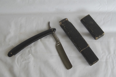 Greensborough Historical Society
Domestic object - Cut-throat razor, Geo. Wolstenholme & Son, Wolstenholme Razor, 1920 c
Men's razor used prior to "safety" razors; still used by some men's hairdressersCut-throat razor, stainless steel hollow ground blade folding into black plastic handle in black cardboard caseI.X.L. Wolstenholme, Sheffield, Eng. The Celebrated extra hollow ground razor. "A. Sargent" label on caserazors, cut-throat razors, shaving -
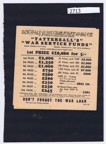 Greensborough Historical Society
Tickets, Mercury Press, Tattersall's War Service Funds, 1940s
Application form for lottery ticket in Tattersall's War Service Funds cash consultation. 200,000 tickets at 5/- eachA "ticket in Tatts" was one of the most popular lotteries available in Australia for many years. This "War Service Funds" sweep allocated money from its proceeds to the R.S.S.A.I.L.A. for distribution among the War Service Funds of all Australian states and New Zealand.Application form, printed in black on white paper, both sideslotteries, tattersall's, world war ii, black family -
4th/19th Prince of Wales's Light Horse Regiment Unit History Room
Book, "The Advocate", 3rd Light Horse Regiment A.I.F. 1914-1919 Unit History
Soft cover booklet, 64 pp -
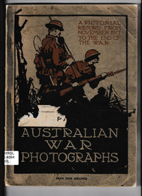 Monbulk RSL Sub Branch
Book, A.I.F. Publications Section, Australian war photographs : a pictorial record from November, 1917 to the end of the war, 1919
A photographic essay of Australian involvement in the Great WarIll, p.143.A photographic essay of Australian involvement in the Great Warworld war 1914-1918 - australian involvement, world war 1914-1918 - pictorial works -
Tatura Irrigation & Wartime Camps Museum
Book, Mayes Australian Price, 1891
Used by C. J. Mitchell, builder, TaturaRed cover, linen finish. Black lettering on front; gold lettering on spine. 6th edition. In ink - C. J. Mitchell, C. J. Mitchell, Tatura and Bearice A. Mitchell on pages 11 and 111.c j mitchell, tatura businesses, tatura builders