Showing 2554 items
matching historic photographs
-
 The Beechworth Burke Museum
Photograph, 1990s--estimated
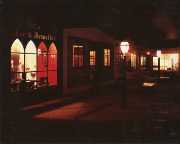
Taken in 1990, this photograph depicts a row of shops in Beechworth, with the shopfront of watchmaker and jewellers, William Turner and C.F. Falck, in the foreground, and newsagent and bookseller James Ingram's shop in the background.This photograph is of social significance to the Beechworth community in depicting the Street of Shops, the creation of curator, Roy Harvey, which opened in 1979 at Burke Museum. According to the Indigo Shire Council webpage for Burke Museum, this addition 'began a new period of collecting with Roy Harvey calling to the community for donations. The response resulted in an influx of material adding to the town history/ development and local identities collections. The Shops and their contents reflect another period in museology.' The historic shopfronts in this image portray those of local settlers, William Turner and CF Falck's Watchmaker and Jeweller store, and James Ingram's news agency and bookshop. William Turner was originally a goldfields official who became a commissioner on the Ovens goldfield, and later a resident warden, at times performing magisterial duties and chairing the Local Court. Charles Frederick Falck, born in Korlin, Germany, in 1833, a skilled watchmaker and jeweller, ran the jewellery business from 1862. Along with William Turner and Melbourne barrister, George Milner Stephen, he prepared a dazzling display of gems and jewellery from Beechworth for the Royal Society's Exhibition in Melbourne in 1865. This act signposted Beechworth's progress as a nineteenth-century gold rush town with a population of around 3000. In the mid-1850s, newsagent James Ingram established a newsagency and supplied papers and stationary to the goldfields. He and bookseller R.T. Vale stocked a wide range of literary, historical and religious works, textbooks, periodicals and newspapers, as well as hosting a reading and writing room on Camp Street{?}. James Ingram was a 'devoted instigator and supporter of the town's welfare institutions', who raised funds for to establish a hospital, primary school and benevolent asylum, and assisted people who'd fallen on hard times with his wife. He was also a mainstay of the early Baptist church, holding meetings in his house. He died in 1928, six weeks short of his 100th birthday. Ingram's Rock, north-west of Beechworth near where he lived in later life, was named after him. Colour rectangular photograph printed on matte photographic paper.Obverse: FALCK 1880 / maker & Jeweller/ WARDENS OFFICE/COACHING OFFICE/ EST. ??55/ ????ON HOUSE/ JAMES INGRAM/ NEWS?????? AND BOOKSELLER/ TOYS visible above shopfront in left foreground. Reverse: Catalogue item number 3305 pencilled in top right-hand corner.beechworth, beechworth historic shops, william turner, cf falck, james ingram, turner and falck watchmaker and jeweller, james ingram newsagent and bookseller, burke museum, promoting settlement, marketing and retailing, living in country towns, making regional centres, preserving traditions and commemorating, beechworth founders, victorian gold rush towns, beechworth pioneers, ingram's rock, 1860s beechworth, street of shops, roy harvey -
 The Beechworth Burke Museum
Photograph, 1990s -- estimated
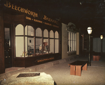
... period in museology.' This photograph evokes the historic ...Taken in the 1990s, this photograph depicts a line of historically restored shopfronts on Ford Street, Beechworth, with Beechworth Bazaar in the foreground and George Gammon's Chemist and Druggist adjacent to it.This photograph is of social significance to the Beechworth community in depicting the Street of Shops, the creation of curator, Roy Harvey, which opened in 1979 at Burke Museum. According to the Indigo Shire Council webpage for Burke Museum, this addition 'began a new period of collecting with Roy Harvey calling to the community for donations. The response resulted in an influx of material adding to the town history/ development and local identities collections. The Shops and their contents reflect another period in museology.' This photograph evokes the historic shopfronts of Beechworth Bazaar and George Gammon's Chemist and Druggist from the Street of Shops, which were established during the mid-1850s on the back of gold mining wealth. The expansion of banks within Beechworth also stimulated the local economy.Colour rectangular photograph printed on gloss photographic paper.Obverse: BEECHWORTH BAZAAR est. 1855/ CHINA GLASSWARE SILVERPLATE EARTHENWARE/ ?ESTER HO?E/ R.?ALL. ? LT.LITTLEWOO?/ SINGLEMAN & RIEDLE GEORGE GAMMON/ MEDICAL GALVANISM/ CUPPING/ TEETH EXTRACTED/ CHEMIST & DRUGGIST Reverse: 3. 3055 burke museum, beechworth, beechworth bazaar, 19th-century victorian history, beechworth historic shops, burke museum, promoting settlement, marketing and retailing, living in country towns, making regional centres, preserving traditions and commemorating, victorian gold rush towns, beechworth pioneers, 1850s beechworth -
 The Beechworth Burke Museum
Photograph, c1990
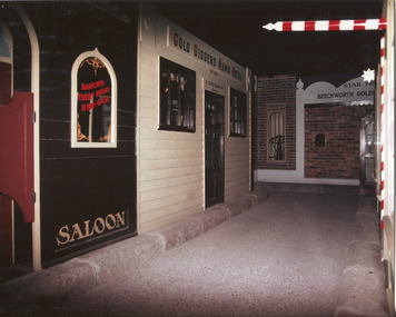
Taken in the 1990's, this photograph depicts a row of shop fronts in the 'Street of Shops' exhibition in the Burke Museum in Beechworth. This exhibition was created and opened in 1979 and was intended to reflect and imitate a historic peirod in the town's past. The time period decpicted is that of the Gold Rush which swept through many Victorian towns from the 1850's onwards. For the town of Beechworth, the gold rush began in 1852, when gold was discovered in Spring Creek, drawing in many new residents seeking to make a fortune and transforming a once remote town into a bustling centre brimming with hope and opportunity. By 1857, the town contained over 200,000 residents and with this, the need for more amenities and intsitutions arose. Multiple churches, banks, schools, shops, hospitals and other essential buildings appearing over the years. The wealth acquired through the gold rush is largely responsible for the vast development of the town and many of its significant buildings which still remain to this day. This photograph also highlights the significance of this type of exhibition, providing a new mode of experiencing and learning about the past. The street depicts the many supporting trades and industries that arose from the mass migration during the gold rush. The creation of the Street of Shops in 1979 was envisioned by Roy Harvey who was the curator at the time, with the intention of recreating an authentic feel to the environment while collecting from the community to accurately portray the multiculturalism that is ingrainded in many towns and communities of Victoria. This photograph contains historical significance as it relates to and portrays an especially important period of time within Beechworth and Victoria's history. The gold rush phenomena ushered in a wave of hope and prosperity for citizens and immigrants alike. It provided many with the opportunity to strike it rich, while the town prospered and grew in many ways. This widespread development that accompanied the gold rush occured throughout Victoria and holds great historical importance when recording the social, economic and communal developments that occured throughout the time period which gave way to the beloved towns and communities we know today. Beechworth itself is acknowledged as Victoria's best-preserved gold mining town and deserves recognition of its significance. it also showcases the great significance of social develpment and globalization that occured throughout the state during this period. Coloured rectangular photograph printed on matte photographic paper and unmounted. Obverse: Dancing every night 8pm-6am [mirror] / Gold Diggers Arms Hotel façade / Star / Beechworth Gold / J. Davidson / Saloon Reverse: 3306 beechworth, burke museum, street of shops, gold rush, indigo shire gold rush, 1850s beechworth, burke museum exhibitions, saloon, gold buyer, hotel, historical streetscape, gold rush immigration -
 The Beechworth Burke Museum
Photograph, c.1980
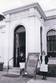
This photograph depicts the entrance to the Burke Museum in Beechworth, most likely in 1980. The building was originally established as the Beechworth Athenaeum in 1857 to provide a lecture hall and reading room at the peak of the gold rush. In 1859, it became the Beechworth Public Library, which is why the writing embossed above the main entry says 'Library' rather than 'Museum'. The building was turned into a museum and renamed the Robert O'Hara Burke Memorial Museum in 1863 in honour of Robert O'Hara Burke, former Police Superindendent of Beechworth who died in 1861 on the Burke and Wills expedition. The Burke Museum has been in almost continual operation since that time. In the 1970s, the building underwent renovations to create several verandas, though the main façade visible in this photograph remained as it was when originally built. The Burke Museum currently contains over 30,000 individual objects, including the Gold Rush era items and the Ned Kelly collection advertised on the a-frame in the photograph. The photograph itself is also part of the Burke Museum collection.The Burke Museum itself is very significant to Victorian history. It is on both the Victorian Heritage Register and is part of the National Trust due to its relevance to the history of the Gold Rush period, its architectural features, and its significant collection. Photographs of it throughout its history are an important part of telling the museum's story. This photograph in particular highlights what the museum staff believed would be appealing to a 1980s public, evident by the A-frame advertising board.A black and white rectangular photograph printed on photographic paper.Top right text: 5147. Bottom left text: Beryl Seatt (or possibly Scatt) & friend 1980beechworth, burke museum, beechworth museum, beechworth historic precinct, architecture, museum, library, 1980s, 1980s australia, museum staff -
 The Beechworth Burke Museum
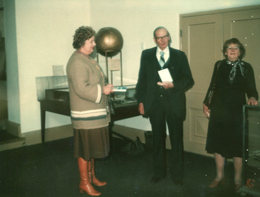
Photograph, 14/05/1979
... . This photograph is of historic significance as it depicts known ...Taken on 14 May 1979, this photo depicts Mr Alan J. Dunlop and his wife presenting a 2.86-gram solid gold nugget found in the Beechworth area more than 100 years ago, to the Shire President, Councillor Mrs Valerie Mason. The gold is reported as attached to a small amount of milk quartz mounted onto a tie pin, and was donated to the Burke Museum by the Dunlop family. Alan Dunlop, pictured, was Sir Edward 'Weary' Dunlop's older brother. The tie pin artefact being donated in this photograph is entered into the Victorian Collections, and records that the nugget was found in the Beechworth Goldfields by Mr Fred McIntosh, in the last 1800s. Fred McIntosh, the husband of Elizabeth (Bessie) Dunlop (the sister of Alan & Edward's father, John) had the nugget made into tie pin and presented it to the Dunlop Family. Furthermore, Valerie 'Val' Mason was the first female president of the former Beechworth Shire for two terms and a councillor for nine years. This photograph is of historic significance as it depicts known individuals who have connections to key Australian figures. Alan Dunlop is the brother of famous war doctor Edward 'Weary' Dunlop, and both men are Beechworth locals. The object Alan holds is a tie pin made from gold found by the Dunlops' uncle, and the provenance of the item – from goldfield to family collection to museum collection – provides a recent context with which to interpret the significance of gold-mining on present and future generations, as well as strong research potential on minerals known to be sourced in the area. In conjunction with other photographs in the collection, this photograph visually documents the donation and acquisition of the tie pin artefact into the Burke Museum Collection. In addition, it depicts Valerie ‘Val’ Mason, in her role as the president of the former Beechworth Shire. Val was the first female in this role, which she held for two terms, and was a councillor in the Shire for nine years. This photograph is of social significance as it depicts two well-known and respected Beechworth locals handling a key artefact of significance to the Beechworth Goldfields. It also shows the Burke Museum in 1979, providing research potential for those interested in the history of the development of the museum's collection. Colour rectangular photograph printed on matte photographic paper.Reverse: Polacolor (Registered Trademark symbol) Type 108 / LR / Mrs Valerie Mason / Mr Dunlop (Weary's brother) / Mrs Vivian Payne (erased) / 14-5-1979 A.J. Dunlop & wife with Cr. Mason /L85052P gold, nugget, tie pin, pin, beechworth, burke museum, goldrush, goldfield, dunlop, edward dunlop, weary dunlop, alan dunlop, valerie mason, fred mcintosh, gold mining, donation, museum, collection, president, councillor, shire, female -
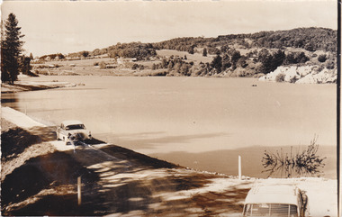
 The Beechworth Burke Museum
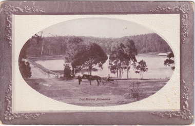
Postcard
Black and white photograph depicts wide shot of Lake Kerford, where an older man stands with a horse and small carriage. On top of the carriage sits a small child, and both face towards the camera to pose. Photograph does not state when it was captured, but possibly been taken c. 1920.The postcard holds Historic significance due to its connection to Beechworth and its Lake Kerford. It demonstrates the interactions between nature and current European residents, especially how the lake has somewhat been 'protected' with the man made fencing and road. It also presents information on the environmental development or degradation for the area, with possible changes to the environment that may have been caused by human physical forces, natural decay or Global Warming. The social significance is due to the connection between the postcard and the individuals in the photograph.Black and white oval photograph on rectangular postcard, printed on card.Obverse: Lake Kerford / Beechworth Reverse: POST CARD / Stamp Here / Printed in Australia / This space may be used for Correspondence within the Commonwealth without extra postage / THIS SPACE IS FOR NAME AND ADDRESS / 84 - 108 - 1 / BMM3000lakes, lake kerford, beechworth, postcard, horse drawn carriage -
 The Beechworth Burke Museum
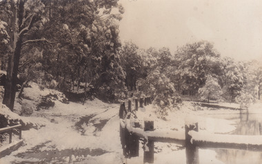
Postcard
This postcard depicts Lake Kerferd during the winter season. With the photograph possibly been taken in the 1930s.The postcard holds Historic significance due to its connection to Beechworth and its Lake Kerford. It demonstrates the interactions between nature and colonialists, especially how the lake is surrounded by man made fencing and roads. It also shows that there was frequent human interaction with the area, due to the small snow slopes where vehicles would travel across. Black and white rectangular postcard, printed on card.Reverse: 56. / A03092 / 97.2205 POSTCARD / AUSTRALIA / KODAK CORRESPONDENCE / ADDRESS ONLY / KODAK / AUSTRALIA 84 - 134 - 1beechworth, lake, postcard, burke museum, black and white photograph, lake kerford -
 The Beechworth Burke Museum
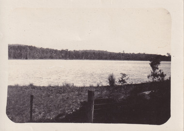
Photograph
... , but possibly c1920. The photograph holds Historic significance due ...Black and white photograph depicts wide shot of Lake Kerford. Photograph does not state when it was captured, but possibly c1920.The photograph holds Historic significance due to the connection it holds to Beechworth and their local Lake Kerford. It demonstrates the interactions between nature and European residents, especially how the lake has been 'protected' by the man made fencing.Black and white oval photograph on rectangular postcard, printed on card.No inscriptions or markings found on either side of the postcard.lakes, lake kerford, beechworth, wire fencing, photograph -
 The Beechworth Burke Museum
Photograph, 1960s
... . This photograph holds Historic significance because of its connection ...Taken around 1960s, this photograph shows the banks of Lake Sambell. Lake Sambell is named after Mr. L. H. Sambell who was instrumental in the lake's formation. Lake Sambell is the original site of the open sluice operation of Rocky Mountain Mining Company in the 1800s and the early 1900s. In the early 1920s, it was reconstructed as a recreational lake and was formally opened to public on 6 October 1928. The opening event was attended by townspeople and Beechworth's Minister of Lands Mr. Bailey. In the late 1930s to early 1940s, Lake Sambell redeveloped. The first development aimed to raise the banks by six feet to double its present area and to make the water cleaner. Another redevelopment in the 1940s was made possible by the Beechworth and District Progress Association. It involved raising the banks to five feet to provide swimming facilities, paddling pool and caravan park. This photograph holds Historic significance because of its connection to the development of Beechworth district.Sepia rectangular photograph printed on matte photographic paperObverse: Reverse: 3533 /beechworth, water scheme, water reserve, catchments, beechworth water reserve, beechworth catchments, municipal council, lakes, reserve, water supply, political projects, environmental changes, mr. l. h. sambell, sambell, rocky mountain mining company, recreational lake, minister of lands, mr. bailey, swimming pool, paddling pool, caravan park, swimming facilities, lake redevelopment, funding -
 The Beechworth Burke Museum
Photograph, 1960s
... and establishment of the lake. This photograph is of historic and social ...This photograph was taken in the 1960s at Lake Sambell Caravan Park, visible in the photograph are individual caravan sites with electricity outlets, a large single-story building, a parked car, and two caravans partially obstructed by trees. Lake Sambell Caravan Park opened in 1959 owing to the work of R.E. Carter, Beechworth Shire engineer from 1954-63. Carter advocated for improvements to the lake and surrounding area in order to encourage tourism in Beechworth. The opening of the caravan park was part of many improvements to Lake Sambell made in this period by Carter including: the swimming pool in 1961, water skiing and boating facilities, and increased lake surface in 1964. These improvements were financed mainly by grants from the Tourist Development Authority. The popularity of caravanning in Australia exploded during this post-war period of the late 1950s and 1960s. This popularity was driven by multiple factors, including: the stopping of fuel rations, the accessibility of car ownership through the manufacturing of affordable cars, technological developments in caravan design, and the increase in prosperity and leisure time for many Australians. Facilities such as electrical outlets to power caravans are present in this photograph of Lake Sambell Caravan Park. Lake Sambell is an artificial lake that was developed on the previous site of the Rocky Mountain Mining Company workings and was officially opened by Minister for Lands, Mr Baily, on October 5, 1928. The disused and unattractive remains of the mine were converted into a recreational area intended for swimming, boating, and fishing. The lake is named after Mr L.H. Sambell, shire engineer and secretary of the Forward Beechworth Committee, who advocated for the enhancement of Beechworth into a tourist destination and was central to the planning and establishment of the lake. This photograph is of historic and social significance in documenting the enhancement of the Lake Sambell area overseen by R.E. Carter and providing insight into caravanning during the 1960s in Australia. Caravanning was extremely popular in Australia during the late 1950s and 60s due to multiple social and economic factors including the stopping of fuel rations, the accessibility of car ownership through the manufacturing of affordable cars, technological developments in caravan design, and the increase in prosperity and leisure time for many Australians. Black and white rectangle photograph printed on photographic paper and unmounted.Reverse: 3538/ [logo back printing KODAK/ VELOX/ PAPER] / C798lake sambell caravan park, lake sambell, lake sambell 1960s, lake sambell fishing, lake sambell boating, lake sambell swimming pool, r.e. carter, l.h. sambell, tourist development authority, caravanning 1960s, caravan electricity outlets, caravan park, forward beechworth committee, rocky mountain mining company, lake caravan park, caravan mid 20th century, beechworth tourism, travel in the 1960s, holiday 1960s -
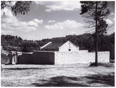 The Beechworth Burke Museum
Photograph
... granite walls were incorporated in the design The photograph shows ...The photograph is of the Powder Magazine and gorge in Beechworth. The Magazine was built for six hundred and ninety-seven pounds in 1859 by "T Dawson and company." However, the walls were constructed later in 1860 by "Atchison and Lumsden," a different building firm. The Beechworth Magazine was one of many made by the government for the storage of gunpowder. However, the building eventually stopped being used as the mining decreased in the area, finally becoming unsused with the invention of nitro-glycerine compounds. The magazine was created to hold large quantities of gunpowder and much of its design was to hinder the prospective of damage. These safety features included double arched foundations and an arched inner roof, which would move a possible explosion upwards. Also, a process of lighting conductors, ventilation and heavy granite walls were incorporated in the designThe photograph shows historic significance due to its association with the mining era in Beechworth in the late 1800s. The photo shows the Powder Magazine after construction, most likely when it was storing gunpowder during a signifiant time period for the region.Black and white photograph printed on paper.beechworth, powder magazine, gunpowder, mining, beechworth powder magazine, explosives, atchison and lumsden, t dawson and company, gorge, granite, granite building, 1860 -
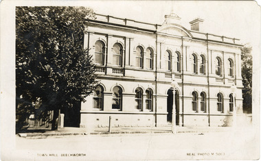 The Beechworth Burke Museum
Photograph - Postcard, Town Hall Beechworth, c1910
Beechworth Town Hall was designed by architects J.J. Coe and Thomas Dalziel and is dated to 1859. The building was made of granite and constructed to local builders Donald and William Fiddes. The original front to the building was replaced by a two story facade in 1889 designed by George Jobbins and built by Thomas Sandham according to a plaque on the front. The Town Hall is remarkable for its vaulted ceilings and columns. Originally the building was used as the Shire Offices but also doubled as a fire station and a courthouse, with still surviving cells underneath. Among the inmates was notorious bushranger Harry Power who was originally transported to Van Dieman’s Land for stealing a pair of shoes. He gained his freedom six years later but spent time in and out of gaol for the rest of his life for a variety of offences including a number of armed robberies. The Town Hall is now home to the Visitor Information Centre which helps visitors with amongst other things, accommodation, tours, event enquiries, and is the commencement point for Precinct walking tours. The Beechworth Town Hall is one of five distinctive granite buildings on Ford Street that comprise the Justice Precinct. It is of considerable historical significance as activity on the site dates from Australia’s gold rush period and was the administrative centre for north-eastern Victoria. The building has seen continual use from 1858 as an important public building and displays many aspects of the history of law enforcement in Victoria. The building is also of substantial architectural significance for its construction from local honey coloured granite, which also showcases early stone masonry techniques and craftsmanship. The Precinct is listed on the Victorian Heritage register and is protected by Heritage Victoria under the Victorian Heritage Act 2017. The buildings are also registered by the National Estate, the National Trust and protected by Indigo Shire Council’s Planning Scheme. Black and White rectangular postcard printed on cardReverse: 1906-1910?beechworth, beechworth town hall, town hall, jj coe, thomas dalziel, granite, beechworth historic building, courthouse, cells, geoge jobbins, thomas sandham, 1859, 1889, walking tours, beechworth historic precinct, historic precinct, harry power, bushranger, australian bushrangers, van dieman's land, transportation, armed robberies -
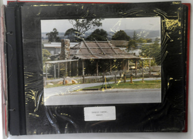 Orbost & District Historical Society
albums, late 1980's
These two albums were used at the Slab Hut - Orbost Visitor Information Centre. The Orbost Visitor Information Centre is situated in Forest Park on Nicholson Street. The centre is housed in the historic Slab Hut. The hut was an original family dwelling built in 1872, on a site approximately three kilometres upstream from the junction of the Buchan and Snowy Rivers. No nails were used in the construction; it was all wired together. After a period in storage the slab hut was opened in its present location in Orbost as the Information Centre in 1987.These albums are contemporary records of the construction and relocation of an iconic Orbost building, the Slab Hut.Two large photo albums. 2280.1 has no front cover. The back cover and spine are red. The pages are black and most photos are labelled. They are photographs of the Orbost area. 2280.2 has brown covers. It contains photographs of the construction of the gardens and buildings around the Slab Hut (Orbost Visitor Information Centre). On the cover in gold print is "PHOTOS".slab-hut-orbost album-photographs-orbost -
 Orbost & District Historical Society
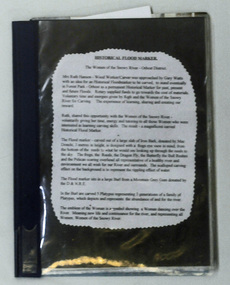
folder, Historical Flood Marker, 1999 - 2001
... and photographs about the Historic Flood Marker in Forest Park, Orbost..., records and photographs about the Historic Flood Marker in Forest ...This folder contains a record of the construction of the flood marker in Forest Park, Orbost. It depicts the six highest floods since the first recording. The construction of the marker was commenced in August 1999 and took eighteen months to be completed by nine volunteers under the tutelage of Ruth Hansen.This item is a contemporary record of the construction of an iconic marker in Orbost.A loose leaf folder containing information, records and photographs about the Historic Flood Marker in Forest Park, Orbost. Most photographs and printed text are glued in. There are twelve loose photographs.The front cover and spine are dark blue, the back is a lighter blue and has a bar code and price sticker attached.flood-marker-orbost -
 Orbost & District Historical Society
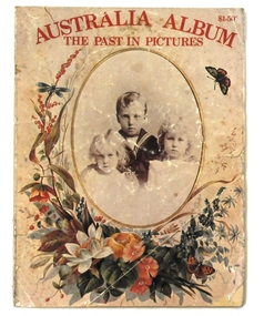
magazine, Australia Album -The Past In Pictures, circa 1974
The magazine was produced as a tribute to Lillian Roxan who was a great Australian and an international journalist. It is not dated but was published by Sungravure Pty Ltd circa 1974-75, The editor, Ailsa Craig wrote for the the magazine Woman's Day in the 1950s and 60s. she had an active career in journalism from 1960-1980. it contains b/w and sepia photographs. This magazine style paperback book contains photos of an earlier Australia.A paper magazine - AUSTRALIA ALBUM -THE PAST IN PICTURES. It contains prints of historic photos. On the front cover is a portrait of three young children dressed in early 19th century clothing. This is inside an oval frame with a gold border. There is a wreath of colourful flowers and butterflies surrounding this.The title is printed in red at the top. In the top right-hand corner is the price $1.50. It was edited by Ailsa Craig and contains photos and text from readers of Womans Day, The Sydney Morning Herald, the Sydney Mitchell Library and the Department of the Army. The magazine style book has 94 pp.magazine photos roxon-lillian craig-ailsa -
 Orbost & District Historical Society
black and white photograph, first half 20th century
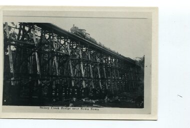
The Stony Creek Trestle Bridge was built in 1916 when the existing rail line from Melbourne to Bairnsdale was extended to Orbost. This 97km Bairnsdale to Orbost extension through rugged terrain was reputed to have been the most difficult rail project undertaken in Victoria. In service for over 60 years the bridge was damaged by bushfire in 1980, with the last train crossing in 1987. At 247m long and 20m high, it is the largest standing bridge of its kind in the State, and is listed on the Register of Historic Sites. Built of red ironbark and grey box timber, it is a fine example of the early engineering skills that utilised the resources and materials found on site.The Bairnsdale to Orbost rail line contains the most varied range of timber & timber composite bridges on any Victorian line. The Stoney Creek bridge is listed on the Victorian Heritage Register for its architectural and historical significance. A black / white photograph of a very tall wooden railway bridge with a train along the top.railway-bridge stoney-creek-bridge east-gippsland-railway -
 Orbost & District Historical Society
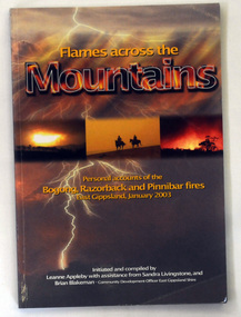
book, Flames Across The Mountains, 2004
This book was initiated and compiled by Leanne Appleby with assistance from Sandra Livingstone and Brian Blakeman. After hearing some of the stories of the events that took place during these fires, Leanne Appleby decided that collating and recording the stories in book form would "perhaps relieve some of the tension and stress". Brian Blakeman as Community Development Officer, East Gippsland Shire, and Sandra Livingstone of Buchan became involved in the project.This is a historic record of events that took place during the 2003 bushfires in the Victoria High Plains.A 206 pp paperback book titled Flames across the Mountains. the front cover is representative of fire and lightning. In the centre is a background of bushfire and the silhouette of two mounted bushmen. The book contains personal accounts of the Bogong, Razorback and Pinnibar fires in East Gippsland, January 2003. It has both b/w and coloured photographs.bushfires reminiscences victorian-high-country -
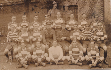 The Beechworth Burke Museum
Photograph
Taken some time between 1914-18, depicted is a large group of unidentified males. Four of them are dressed in Australian military uniforms. The remaining 19 men are dressed in striped uniforms. The male in the centre of the front row is cradling a football, suggesting that the group was part of a football or rugby league team. It is believed that the soldiers in this photograph were part of the Australian Imperial Force. This can be inferred by the chevron rank insignia visible on their uniforms. The placement of this insignia on the sleeve of the right arm suggests that this soldier was either a Warrant Officer or a Non-Commissioned Officer (NCO). Additionally, they are also wearing 'Rising Sun' collar badges on their coats. Australia, unlike most other Commonwealth countries, did not adopt metal regimental badges during the First World War. All units were issued with the Australian Army General Service Badge, better known as the 'Rising Sun’ badge. This insignia is almost always identified with the Australian Imperial Force. Sport has always been entwined with war. Both sport and war demand peak physical fitness, camaraderie, strategy, and allegiance to a team collaboratively working towards a common goal: to win. The connection between sport and war is especially strong in Australia since these two concepts form the basis of our national identity. The Australian War Memorial has a number of World War I recruitment posters linking war and sport in its collection. One of the posters produced in 1915 by the State Parliamentary Recruiting Committee in Victoria attempted to shame young men into enlisting by juxtaposing the image of an Australian soldier standing guard over his deceased mate with a photograph of a Victorian Football League match. Another poster, produced in 1917, features vignettes of different sports including cricket, bowling, boxing, kayaking and golf. Its slogan reads, "Join Together - Train Together - Embark Together - Fight Together: Enlist in the Sportman's 1000".The record is historically significant due to its connection to World War I. This conflict is integral to Australian culture as it was the single greatest loss of life and the greatest repatriation of casualties in the country's history. Australia’s involvement in the First World War began when the Australian government established the Australian Imperial Force (AIF) in August 1914. Immediately, men were recruited to serve the British Empire in the Middle East and on the Western Front. The record has strong research potential. This is due to the ongoing public and scholarly interest in war, history, and especially the ANZAC legend, which is commemorated annually on 25 April, known as ANZAC Day. Additionally, the record presents a unique opportunity to further explore the relationship between the arts, sport and war. This statement of significance has already established that war is integral to Australia's national identity - and sport is of equal importance. Specifically, the record begs to question how the peak physical fitness and camaraderie valued in team sports were creatively translated into military recruitment campaigns during World War I. Evidently, this record and its historic context demonstrates that there is potential here, and if further research is completed on this topic, it may provide insight into Australian military recruitment tactics used in the past and present, and into the future.Sepia rectangular photograph printed on matte photographic paper mounted on card.Reverse: 6529 / hyossest (?) / (?)1/11/1 /military album, army, military, war, wwi, world war i, sport, football, rugby, aif, australian imperial force -
 The Beechworth Burke Museum
Photograph, Unknown
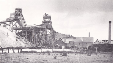
The A1 Gold Mine is located north of Woods Point, near Jamieson, in the Upper Goulburn region of Victoria. Gold was discovered at the A1 site in 1861 and mining operations began in 1864. The A1 Mine Settlement refers to a small township known variously as Castle Reef, Castle Point, and Raspberry Creek, which developed in the 1860s around mining industry centred on a crushing machine that worked the three gold reefs in the area. Historically, the name "A1"referred to the high quality of gold found in the quartz reefs at depths of at least two thousand feet. Along with the Morning Star mine at Woods Point, the A1 gold mine produced almost sixty percent of Victoria's gold output in the 1950s to 1970s and continued operating until 1992 when it went into administration. Operations at the site were revived in 2016 and the A1 Mine is now considered one of Victoria's premier gold mines. The A1 mine is part of the extensive and prospective Lachlan Fold Belt, a north-west trending belt of tightly folded Early Devonian sedimentary rocks extending from New South Wales to Victoria. Mineralisation is hosted within or immediately adjacent to diorite dykes. Contemporary development of the 'Queens Lode' at the A1 mine signals a move from high-grade, narrow vein airleg mining into larger scale, mechanical mining designed to increase ore production volume. This original, undated photograph of the A1 Mine appears to depict an area or phase of disuse or abandonment. The aged and humble appearance of the cottage suggests association with the historical A1 Mine Settlement, therefore the image may have been taken prior to the 1950s-1970s revival period in which the A1 mine is known to have produced high gold yields. The photograph contributes to our understanding of the A1 Gold Mine's impact on the landscape and the social, environmental impacts of mining on communities and may be compared with others in the Burke Museum's extensive collection of mining photographs to deepen our understanding of mining in the Jamieson area.Black and white rectangular photograph printed on photographic paperReverse: 5577 / A1 Mine / Near Jamieson / Vic. /burke museum, beechworth museum, beechworth, gold fields, gold rush, victorian gold rush, mining tunnels, gold ming history, colonial australia, australian gold rushes, mining technology, beechworth historic district, indigo gold trail, indigo shire, upper goulburn shire, jamieson, woods point-walhalla goldfield, a1 gold mine, victorian high country, modern mining methods, orogenic gold province, gold mineralisation, devonian, dykes -
 The Beechworth Burke Museum
Photograph - Photograph - Reproduction, ca. 1900
This image shows the approach to Beechworth from the south-west via the Newtown Bridge. Numerous early buildings line the road as it bifurcates to become Ford and High Streets on the ridge above Spring Creek and Newtown Falls. The sloping, rocky terrain and water course along the gorge show evidence of the intense mining activity that occurred at the site. The Ovens Gold Rush at Beechworth started when gold was found at Spring Creek in February 1852, prompting an influx of miners from around the world. The population grew over 20,000 by 1857. While the earliest mining at Beechworth was similar to that in other Victorian goldfields like Ballarat and Bendigo, Beechworth is notable for its use of hydraulic sluicing as a major method of removing wash-dirt. Hydraulic sluicing employs high pressure jets of water to blast away large areas of earth and wash it down to be run through a sluice box. Gold gets caught in the sluice and the remaining slurry is washed away. This method of mining is extremely effective but causes significant environmental impacts and damage to waterways. Large water quantities were required for large-scale sluicing, and the long water races and deep tailraces that were constructed in the Beechworth area in the nineteenth century are nonetheless considered feats of engineering. The site in the photograph is associated with the Rocky Mountain Mining Company who constructed an eight hundred meter tunnel under the township between 1876-1880 to reduce water levels at Spring Creek, which had been subject to diversions since the earliest days of alluvial mining. Over four million ounces of gold (115 tones) were found at Beechworth between 1852 and 1868, and the wealth from the gold rushes built Beechworth and the nationally significant buildings that remain standing today.This image shows the early development of the Beechworth township above Spring Creek, where gold was discovered in 1852. Evidence of hydraulic sluicing, a uniquely predominant method at Beechworth, and water-works engineering are present in the landscape. By the 1870s, alluvial gold deposits were depleted and increasingly complex engineering was required so deeper shafts could reach bedrock. This image is significant for understanding changes to the landscape and the evolution of mining methods and engineering practices related to the extensive construction, manipulation and management of water networks. The shift from smaller scale alluvial mining to larger company dominance in the mining industry has implications for understanding wider social, economic, political and industrial changes in the region of Beechworth and within the context of the Victorian Gold Rush more broadly. A black and white rectangular reproduction photograph printed on photographic paper. burke museum, beechworth museum, beechworth, gold fields, gold rush, victorian gold rush, hydraulic sluicing, rocky mountain mining company, spring creek, netwown falls, mining tunnels, water races, tailraces, colonial australia, australian gold rushes, mining technology, beechworth historic district, indigo gold trail, migration, indigo shire, gold mining, gold mining history -
 The Beechworth Burke Museum
Photograph - Photograph - Reproduction
This photograph depicts the Great Southern Mine located in Rutherglen as it was during the 1900. After the initial Gold Rush of 1853-1854, Gold was discovered deeper under the surface of the earth in the 1860 after the discovery of another deep lead system. Due to the discovery of Gold in Rutherglen, Rutherglen developed into a community in its own right, possessing a population of 6600 by December 1860 and developed into a municipality in 1862. The Great Southern Mine depicted in this photograph required the use of a range of modern technologies, including the hydraulic pumps, in order to reach gold. This photo depicts the mining operations as they were undertaken around the turn of the century.The search for gold is ingrained into the history of Victoria and therefore, images like this one which portray a modern mining operation undertaken in the 1860s, can reveal important information for society and technology for the date when the photograph was taken. This image is of important historical significance for its ability to convey information about the methods used to extract gold in 1900. It is significant as most mining operations around the region, particularly earlier on in the period, used different technologies such as water races. This image is important for current research into the history of Rutherglen more generally, a town which developed singlehandedly due to the discovery of minerals and mining, as depicted here in this photograph, thus indicating an element of social significance as well as historic. The Beechworth Burke Museum has additional images relating to mining and Rutherglen which can be analysed and studied alongside images like this one.A black and white rectangular photograph printed on matte photographic paper.Reverse: $ 3.00 19972503 / a02503 / Great Southern Mine Rutherglen 1900rutherglen mine, rutherglen, great southern mine, beechworth, mine, mining, post goldrush, victoria, gold, 1860s, sluicing, hydrolic sluicing -
 The Beechworth Burke Museum
Photograph - Photograph - Reproduction, Unknown
This image is a reproduction of an 1899 original depicting the 'Williams Good Luck Mine' on the Mopoke Reef (also called 'Morepork Gully') in the Dingle Ranges, approximately three miles from Beechworth. The foreground of the image is littered with piles of smashed rock and detritus, known as ‘mullock’, beside a reinforced mine shaft, a vertical access passageway allowing miners to enter the mine and haul ore out using lifting technology such as a poppet heads, whims or windlasses. A group of miners and a dog appear close to an open-sided miner’s hut. Following the discovery of gold at Beechworth in 1852, rushes quickly followed at surrounding creeks and gullies in the district. In the late nineteenth and early twentieth centuries, small syndicates of miners continued to work old or abandoned quartz reefs, often persisting without the assistance of heavy machinery to remove the large amounts of rock, in order to obtain yields at ever greater depths. The group of miners in this photograph are Mr. Roger Williams and Sons, who revived operations at the ‘Old Good Luck’ mine on the Mopoke Reef in the Dingle Range near Beechworth around 1892, working the site for more than two decades. An emigrant from Cornwall with experience in the tin mining industry, 19 year old Roger Williams senior sailed to New Zealand in 1840, then to Australia where he spent time in the Bendigo Gold Fields before settling in Beechworth in the early 1860s. Mr Williams senior worked on various mining activities in the district, including the Rocky Mountain Tunnel project. Conversant with the character of gold-bearing reefs in the area, the syndicate dug an eight hundred foot tunnel, digging down as far down as two hundred feet with little capital save their labour, to connect and provide better working access to the mass of reefs and veins in the vicinity. Progress was hampered by poor air quality charged with fumes from dynamite and large quantities of rock had to be crushed to obtain payable yields. The Victorian Goldfields are filled with ruins and remnants of the area's rich mining history, ranging from small alluvial diggings to the remains of huge mining companies. Site names often changed several times throughout the nineteenth and twentieth centuries. Some sites were abandoned and forgotten, others were worked continuously over many decades. The names of mines were often repeated at different locations throughout the Victorian Goldfields. For example, there is a Mopoke Gully heritage mine near Fryers Creek, Victoria. 'Mopoke' is a common onomatopoeic name for Morepork and Australian Boobook owls. This image has historical, social and research significance for patterns of emigration during of the Victorian Gold Rush, and the historical, social and environmental impacts of mining at Beechworth at the turn of the nineteenth and twentieth centuries. As gold became scarce and government support and large company investment waned, poor hard-working miners laboured intensively to make a living through periods of high unemployment. This image can be compared and studied alongside other historical mining photographs and objects in the Burke Museum Collection. It has potential to improve our understanding of miners working conditions and the shifting character of mining in the Beechworth district. Black and white rectangular reproduction photograph printed on matte photographic paper.Obverse: Williams Good Luck Mine Beechworth / Roger! / Reverse: 6858 / burke museum, beechworth museum, beechworth, gold fields, gold rush, victorian gold rush, gold ming history, colonial australia, australian gold rushes, mining technology, beechworth historic district, indigo gold trail, migration, indigo shire, good luck gold mine, victorian goldfields, mining syndicates, gold fever, quartz-mining, small-scale mining, old good luck mine, mopoke gully, quartz reefs beechworth -
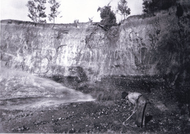
 The Beechworth Burke Museum
Photograph, 1920-1950
... in the landscape. This photograph has historic and research potential ...This image taken between 1920-1930 depicts open-cut hydraulic sluicing at the Three Mile Mine, located about five kilometres south of Beechworth. Alluvial, or surface, mining began on this site in the 1850s, but was soon replaced by hydraulic sluicing methods. By the start of 1880 it is estimated that nine hundred miles of water races had been cut though soil and rock in the Beechworth district. Hydraulic sluicing employs high pressure jets of water to blast away large areas of earth and wash it down to be run through a sluice box. Gold gets caught in the sluice and the remaining slurry is washed away. Large water quantities were required for hydraulic sluicing, and the long water races and deep tailraces that were constructed were considered great engineering feats. This method of mining is extremely effective, but causes significant environmental damage and impacts to waterways and agricultural operations. Miners at Beechworth built extensive networks of races and dams to secure reliable supplies of water on a scale far greater than elsewhere in Victoria. By the 1880s Beechworth's water barons continued to hold more than half of all the water right licences on issue and undertook sluicing operations on a massive scale. The manipulation of surface and ground water via race networks was well planned and recorded in detail by local mining surveyors. The maps that were created, combined with modern geo-spatial technologies, provide a vital key in understanding the great lengths to which miners went to capture and control critical water resources. Today, Three Mile mine is called Baarmutha. The Three Mile Mine was unproductive until 1865 when John Pund and three other miners secured a fifteen year license and constructed a water race from Upper Nine Mile Creek to Three Mile Creek. In the early twentieth century Pund & Co. averaged over one thousand ounces of gold per year from the mine. After Pund's death in 1915, GSG Amalgamated Co operated the site, continuing sluicing until 1950. This image of hydraulic sluicing methods shows the extent of water-works engineering in the landscape. This photograph has historic and research potential for understanding changes to the landscape, the evolution of mining methods, and the extensive construction, manipulation and management of water networks in the Beechworth district. Black and white rectangular photograph on matte paperReverse: 7597-1 / Sluice Mining / Copied from original on loan from Webb (Qld) / Donated Nov 2009 / Baarmutha Three Mile Mine c1920-1950 / Managed by the Plain Bros then Parkinsons / Current Location is: Beechworth Animal Shelter / used for Baarmuthaburke museum, beechworth museum, beechworth, gold fields, gold rush, victorian gold rush, hydraulic sluicing, spring creek, netwown falls, mining tunnels, water races, tailraces, gold ming history, colonial australia, australian gold rushes, mining technology, beechworth historic district, indigo gold trail, indigo shire, john pund, water manipulation, water engineering, three mile creek, three mile mine, water race, large-scale mining methods, historical mining construction, alluvial mining, mining environmental impacts, baarmutha, water barons -
 The Beechworth Burke Museum
Photograph, Circa 1920 - 1950
... Relating to the Goldfields (21 Vic no. 32). This photograph shows ...Taken between circa 1920 - 1950 this photograph depicts a man dressed in dark trousers, a white long sleeved shirt and broad-brimmed workers hat digging around in the Three Mile Mine at Barramutha. The mine was an important gold resource and was typically mined using a method known as hydraulic sluicing whereby high powered water jets are used to dislodge rock or move sediment. The remaining water sediment slurry is directed through sluice boxes to remove the gold. The Beechworth mining district was one of six mining districts established by the governor-in-council on 4th of January 1858 under the provisions of An Act for Amending the Laws Relating to the Goldfields (21 Vic no. 32). This photograph shows historic and research value into the historical methods of hydraulic sluicing in the Beechworth mining disctrict. It also shows the evolution of the mining methods and has potential for understanding future engineering endeavors in the context of victorian mine goldfields. Black and white rectangular photograph printed on matte photographic paper.Reverse: 7597.3/ Copied from original on loan from Webb (QLD)/ Donated Nov 2009/ Barnawatha Three Mile Mine 1920-1950/ Owned by Plain Bros then Parkinsons/ Managed by John Weir, Peter Jenson, Jack Cox/ Slicing. three mile creek, three mile goldfields, three mile beechworth, goldfields, #beechworth, hydraulic mining, hydraulic sluice, burke museum -
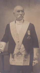 The Beechworth Burke Museum
Photograph
This photograph, taken by Courtney’s Thelma Studios in Wangaratta, depicts Sergeant Arthur Loftus Maule Steele standing in the regalia of the Masonic Lodge. Before his death, Steele was a long term member of the St John’s Lodge of Masons where he was a Past Master and held office of treasurer for over thirty years. He was also a dedicated member of the Church of England and was an Electoral Inspector for Wangaratta. Steele was Sergeant of Police in Wangaratta for much of his life. He was one of 17 children born to Captain Robert Ball Steele and Mary Babington in Tours, France, in 1839. His parents were travelling at the time and soon after settled in Donegal, Ireland. At the age of 12, Steele was sent to the Military Academy of Dublin where he passed his examinations and prepared to enter the British Army. Steele met a bother of Robert O’Hara Burke and was advised to travel to Australia and join as a police cadet. Steele took the advice and travelled to Australia, arriving in Melbourne at the age of 17. He spend some time in a variety of employment including working as a clerk for the White Star Line. He entered the Victorian Police force in 1856. By 1864, Steele married Ruth Ingram Ballinger at Snowy Creek and worked at Omeo until being promoted to the mining centre of Beechworth, taking charge of the Yackandandah Station. Steele and Ballinger had ten children. Steele is well known in Victorian history for a variety of reasons, the most famous being the role he played in capturing Edward “Ned” Kelly at Glenrowan on the 28th June 1880. He also arrested Frank Neville (for the murder of a local resident Mr Nicholls) and Patrick Sheehan (first person to be executed in the Beechworth Gaol 1865 for the murder of James Kennedy at Rowdy Flat Yackandandah). He later worked on the case of Bridget Mepham (charged with the murder of her sister) at Wangaratta and retired from the Police force on the 1st of August 1896. In this retirement, Steele was a keen horticulturalist who enjoyed observing the habits and growth of new varieties cared for in his conservatory. Steele passed away in February 1914. This image has the potential to support current research on Sergeant Steele, the Masonic Lodge and photography during the c.1890s. Sergeant Steele is a well-researched member of the Victorian Police force and is known primarily for his involvement with the Kelly Gang. Therefore, depictions of Steele through photography can help to provide essential information about Steele outside of the Police force. This image has the capacity to inform about Steele’s involvement with the Masonic Lodge in Wangaratta. Therefore, it is important for what it can reveal regarding historic and social aspects. The Burke Museum is home to a large collection of Kelly centred photographs. The study of these photographs in connection to those in other museums have the ability to further current understanding on important figures and events in this historic occasion.Black and White rectangular photograph printed on matte photographic paper and mounted on an oval boardObverse: Courtney's Thelma Studios/ Wangaratta Reverse: 2747portrait, ned kelly, uniform, policeman, wangarratta, sergeant, steele, 1880, photograph, oval, black and white, sergeant steele, arthur loftus maule steele, arthur steele, wangaratta, beechworth -
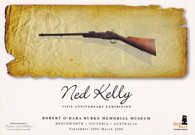 The Beechworth Burke Museum
Postcard, 2005
To commemorate the 125th anniversary of Edward “Ned” Kelly’s committal trial in the Beechworth Historic Courthouse, the Robert O’Hara Burke Memorial Museum (henceforth Burke Museum) commissioned this postcard to coincide with their exhibition dating September 2005 to March 2006 and titled the Ned Kelly 125th Anniversary Exhibition. The postcard depicts a Snider-Enfield of .577 calibre which was reputedly favoured by the Bushranger. The firearm is of typical 1870s hunting design and was displayed as a focal point within this exhibition. The firearm, which was named “Betty” was reportedly taken by Kelly from Henry Dudley. The weapon has the letter ‘K’ engraved into the wood of the fore end. Other items also displayed in this exhibition include the Burke’s Kelly death mask, a replica of the Kelly Gang armour and photographs from the Burke Museum’s Kelly album. This postcard advertises an exhibition held at the Beechworth Burke Museum to commemorate the 125th anniversary of Kelly’s committal trial, which took place in Beechworth's historic courthouse. The selection and interpretation of items like the gun called 'Betty' are significant for understanding the changing nature of Kelly scholarship, treatment and curation, in particular, the popular and iconic myth of the Australian bushranger. The item can be compared with other Kelly photographs in Burke Museum's collection.Rectangular colour printed postcard celebrating Ned Kelly 125th Anniversary Exhibition at Burke Museum, Beechworth. Inset image of Ned Kelly's rifle. Obverse: Ned Kelly / 125th ANNIVERSARY EXHIBITION / ROBERT O'HARA BURKE MEMORIAL MUSEUM BEECHWORTH . VICTORIA . AUSTRALIA / September 2005-2006 / BEECHWORTH / Echoes of History / HISTORIC & CULTURAL PRECINCT / NED / KELLY / TOURING ROUTE / REVERSE: Ned Kelly / 125th ANNIVERSARY EXHIBITION / ROBERT O'HARA BURKE MEMORIAL MUSEUM BEECHWORTH . VICTORIA . AUSTRALIA / September 2005-2006 / AFFIX STAMP HERE / 7250 / This is the rifle that was taken from Henry Dudley by Ned Kelly. It became Ned's favourite / rifle, which he called 'Betty'. Note the 'K' carved into the wood of the fore-end. / Interestingly, there is at least one other rifle owned by Ned Kelly that also has a 'K' engraved / into it by Ned- the Colt revolving carbine used by Ned at Glenrowan /kelly album, ned kelly exhibition, ned kelly's rifle, betty, snider-enfield, .557 caliber, rifle, revolver, exhibition, beechworth, burke museum, 125th anniversary, firearm -
 The Beechworth Burke Museum
Photograph, 1907-8
The photo from 1907-8 is a sepia print, depicting a small valley with building at base. There are flumes visible above areas of water, trees on hills and a few small cottages on the hillside. Cock's Pioneer Gold & Tin Sluicing Co NZ No 2 Site. The photo was taken of Matthews Gully looking west. Sluicing was undertaken in the area from 1900 to 1942 with some short breaks between these periods. The image depicts a location mined by Cocks Pioneer Gold and Tin Sluicing Company (as recorded on the annotation on the card mount) The Cocks Pioneer Gold and Tin Mines N.L was one of El Dorado's two largest open cut sluicing mines of the 20th Century. The other was named the Cocks El Dorado Gold Dredging Company. The Cocks Pioneer Mines operated from 1901 until 1941 and found a total of 117,378 ounces of Gold and 1,673 tones of tin concentrates over these years. The Cocks company was formed in 1898 and operated until 1941. Open cut sluicing involved the use of high-powered hoses which used the centrifugal sand pump system (known as hydraulic sluicing) which broke down the soil which was then processed for gold and other precious metals. From 1914 , four years after this image was captured, the company reformed to Cocks Pioneer Gold and Tin Mines NL (previously it was known as Cocks Pioneer Sluicing Co) and undertook large scale sluicing operations until 1929 and then 1934-1941. El Dorado is located on Reedy Creek and is surrounded by forested country to the north and east. It is 20 km east of Wangaratta in Victoria's regional north-east. John Cock was the son of a Cornish minor who arrived in El Dorado in 1858. Cock founded his gold and tin mining company which ran successfully for many years in the El Dorado region. It was an open cut sluicing company because of the abandonment of underground mining after this was deemed too dangerous. In 1935 Cock's El Dorado Company commissioned the floating dredge which is still visible in El Dorado today. The dredge was built by the Thompson engineering works, Castlemaine, and weighed over 2,000 tones and today has a place on the Victorian Registers of historic buildings. Interestingly, the name El Dorado does not derive from the gold in the region, but from the Barambogie pastoral run completed by William Baker in 1840-1841. Gold was discovered in El Dorado 1854 but the gold was too deep for individual prospectors to find, it required the use of heavy machinery.The search for gold is ingrained into the history of Victoria and therefore, images like this one which portray an open cut sluicing site can reveal important information for society and technology for the date when the photograph was taken. This image is of important historical significance for its ability to convey information about sluicing and the methods used to find gold in 1910. It also shows a location where sluicing was undertook which provides insight into the impact of sluicing on the environment at a time when it was done. This image is important for current research into the history of El Dorado, a small regional location near Wangaratta in Victoria's North East. Therefore, this image has the capacity to be beneficial for research into society and the motivations of those living and working in this region during this period and therefore, has social significance. The Beechworth Burke Museum has additional images relating to gold sluicing and El Dorado which can be analysed and studied alongside images like this one.Sepia coloured rectangle photograph printed on gloss photographic paper Reverse: 1997. 2613/ A02613/ No2 site/ Matthews Gully/ Cocks Pioneer G&T. ?? Co NZ/ No2 Site looking West/ 1907-8/ (7)sluicing, hydraulic sluicing, 1907, 1908, mining, cock's pioneer gold & tin sluicing co nz, nz, site no 2, matthews gully, west, valley, building, cottages, hillside, trees, water, gold and tin mine -
 The Beechworth Burke Museum
Photograph, 1910 - 1911
This photograph depicts Cock's Pioneer G & T Sluicing site No. 4 in El Dorado. Looking eastwards, the photo captures a wooden and tin building with various mining equipment strewn in the foreground. Underneath the verandah, figures can be seen. These are believed to be a Mr. Hollister (left), Mrs. Breustedt (4th from left), children Min and Chris Breustedt, and Kate Timmons holding a girl's hand. The Cocks Pioneer Gold and Tin Mines N.L was one of El Dorado's two largest open-cut sluicing mines of the 20th Century. The other was named the Cocks El Dorado Gold Dredging Company. The Cocks Pioneer Mines operated from 1901 until 1941 and found a total of 117,378 ounces of Gold and 1,673 tones of tin concentrates over these years. The Cocks company was formed in 1898 and operated until 1941. Open cut sluicing involved the use of high-powered hoses which used the centrifugal sand pump system (known as hydraulic sluicing) which broke down the soil which was then processed for gold and other precious metals. From 1914, four years after this image was captured, the company reformed to Cocks Pioneer Gold and Tin Mines NL (previously it was known as Cocks Pioneer Sluicing Co) and undertook large-scale sluicing operations until 1929 and then 1934-1941. The Cocks Pioneer was an extremely successful mining company during the 20th century. In the Annual Report of the Secretary for Mines for the year 1915, the Cocks Pioneer was the largest producer of gold and tin collecting 5,535 ozs. of gold and £7,500 of tin. Twenty years later in 1935, Cocks Pioneer was still one of the most profitable mines in Victoria, ranking as the second-highest dividend paying mine. The company produced a total of 3,650 kg of gold. El Dorado is located on Reedy Creek and is surrounded by forested country to the north and east. It is 20 km east of Wangaratta in Victoria's regional northeast. John Cock was the son of a Cornish miner who arrived in El Dorado in 1858. Cock founded his gold and tin mining company which ran successfully for many years in the El Dorado region. It was an open-cut sluicing company because of the abandonment of underground mining after this was deemed too dangerous. In 1935 Cock's El Dorado Company commissioned the floating dredge which is still visible in El Dorado today. The dredge was built by the Thompson engineering works, Castlemaine, and weighed over 2,000 tones and today has a place on the Victorian Registers of historic buildings. Interestingly, the name El Dorado does not derive from the gold in the region, but from the Barambogie pastoral run completed by William Baker in 1840-1841. Gold was discovered in El Dorado in 1854 but the gold was too deep for individual prospectors to find, it required the use of heavy machinery.The search for gold is ingrained into the history of Victoria and therefore, images like this one which portray an open cut sluicing site can reveal important information for society and technology for the date when the photograph was taken. This image is of important historical significance for its ability to convey information about sluicing and the methods used to find gold in 1910. It also shows a location where sluicing was undertook which provides insight into the impact of sluicing on the environment at a time when it was done. This image is important for current research into the history of El Dorado, a small regional location near Wangaratta in Victoria's North East. Therefore, this image has the capacity to be beneficial for research into society and the motivations of those living and working in this region during this period and therefore, has social significance. The Beechworth Burke Museum has additional images relating to gold sluicing and El Dorado which can be analysed and studied alongside images like this one.A black and white copy of a sepia coloured rectangular photograph printed on matte photographic paper mounted on boardObverse: COCKS PIONEER G + T SL CO, N.L. / 1910 - 11 / NO 4 SITE LOOKING EAST / 4 Reverse: 1997.2508 / AUG 29 1909cocks pioneer gold and tin sluicing company, el dorado, mining, sluicing, hydraulic mining, hollister, breustedt, timmons, gold, tin, gold rush, victoria -
 The Beechworth Burke Museum
Photograph, 1910
This photograph dating to 1910 depicts an open cut sluicing site located in El Dorado captured looking east up the open cut from the number 3 Barge site. Sluicing was undertaken in the area from 1900 to 1942 with some short breaks between these periods. The image depicts a location mined by Cocks Pioneer Gold and Tin Sluicing Company (as recorded on the annotation on the card mount). It portrays open cut rocks with a crevice in the center of the image where the sluicing was being undertaken. There is a small timber structure on the right of the image which could be an entrance to a mine or supports made of wood to prevent a cave in at the open cut site and above the cut rock there is bush. The timber structure has rail tracks on top of the bridge which could suggest the identification of this structure as a mine entrance. The rail tracks were used for little carts which hauled soil from the mine. The Cocks Pioneer Gold and Tin Mines N.L was one of El Dorado's two largest open cut sluicing mines of the 20th Century. The other was named the Cocks El Dorado Gold Dredging Company. The Cocks Pioneer Mines operated from 1901 until 1941 and found a total of 117,378 ounces of Gold and 1,673 tones of tin concentrates over these years. The Cocks company was formed in 1898 and operated until 1941. Open cut sluicing involved the use of high-powered hoses which used the centrifugal sand pump system (known as hydraulic sluicing) which broke down the soil which was then processed for gold and other precious metals. From 1914 , four years after this image was captured, the company reformed to Cocks Pioneer Gold and Tin Mines NL (previously it was known as Cocks Pioneer Sluicing Co) and undertook large scale sluicing operations until 1929 and then 1934-1941. El Dorado is located on Reedy Creek and is surrounded by forested country to the north and east. It is 20 km east of Wangaratta in Victoria's regional north-east. John Cock was the son of a Cornish minor who arrived in El Dorado in 1858. Cock founded his gold and tin mining company which ran successfully for many years in the El Dorado region. It was an open cut sluicing company because of the abandonment of underground mining after this was deemed too dangerous. In 1935 Cock's El Dorado Company commissioned the floating dredge which is still visible in El Dorado today. The dredge was built by the Thompson engineering works, Castlemaine, and weighed over 2,000 tones and today has a place on the Victorian Registers of historic buildings. Interestingly, the name El Dorado does not derive from the gold in the region, but from the Barambogie pastoral run completed by William Baker in 1840-1841. Gold was discovered in El Dorado 1854 but the gold was too deep for individual prospectors to find, it required the use of heavy machinery.The search for gold is ingrained into the history of Victoria and therefore, images like this one which portray an open cut sluicing site can reveal important information for society and technology for the date when the photograph was taken. This image is of important historical significance for its ability to convey information about sluicing and the methods used to find gold in 1910. It also shows a location where sluicing was undertook which provides insight into the impact of sluicing on the environment at a time when it was done. This image is important for current research into the history of El Dorado, a small regional location near Wangaratta in Victoria's North East. Therefore, this image has the capacity to be beneficial for research into society and the motivations of those living and working in this region during this period and therefore, has social significance. The Beechworth Burke Museum has additional images relating to gold sluicing and El Dorado which can be analysed and studied alongside images like this one.Sepia coloured rectangular photograph printed on gloss photographic paper mounted on board.Obverse: COCKS PIONEER Q + T SL CO, N.L. / 1910 / LOOKING EAST UP OPEN CUT / FROM NO3 BARGE SITE / Reverse: 1997 . 2611 / A02611el dorado, north east gold, sluicing, gold sluicing, hydraulic sluicing, 1910, gold and tin mine, open cut mining, mining, gold mining, north-east victoria, beechworth, burke museum -
 The Beechworth Burke Museum
Photograph, J. Collins, c.1940-1950s
... is of great historic and architectural significance, photographs like ...This photograph was captured sometime between an estimated 1940s-1950s. It depicts the Beechworth Benevolent Asylum (later the Ovens and Murray Hospital for the Aged) which was built in 1862. It is located on an elevated site in Beechworth, Victoria because it was believed the height was beneficial to the health of the patients at the Benevolent. Later wings were added to the original building between 1867 and 1890. The building was constructed in an unusual Flemish Gothic Revival style which contrasts with the classical style of the Mayday Hills Hospital in close proximity to the Benevolent. The Hospital was designed in Italianate Revival architecture. The appearance of buildings like the Mayday Hills Hospital and the Ovens Benevolent Asylum are representative of the importance of Beechworth as a town shortly after the goldrush. During the 1850s and 1860s, administration buildings were erected alongside churches, shops and structures of justice. This marks a movement away from the "chaotic" structure of life on the goldfields and towards a more civilised and cultural lifestyle. This social phenomenon is also witnessed in Melbourne with the creation of buildings like the State Library and the University of Melbourne. The Beechworth Benevolent Asylum was renamed the Ovens Benevolent Home in 1935. The Asylum had been set up to provide accommodation and care for permanently injured gold miners, and for women and children who were penniless, homeless, or whose parents were guests of the state. In 1954 it was renamed as The Ovens and Murray Home (as pictured in this photograph). The purpose of this building was to provide a refuge for the poor and destitute, homeless older men, deserted women and children along with providing care for the mentally ill. These buildings were built at the government's expense and are of great historical and architectural significance.This photograph depicts the Ovens and Murray Home (previously the Ovens Benevolent Home) during the 1940s or 1950s. Since this building is of great historic and architectural significance, photographs like this are especially valuable in reconstructing the use history and any changes/additions to the building over a period of time. This building is important for what it can reveal about society in Beechworth and also architectural styles. This building is made in the Flemish Gothic Revival style which is quite unusual for the 1860s. It is important as an early example of a building constructed for a specific purpose, in the case of this particular building: caring for the aged/destitute. This building is important for research into the civic development of Beechworth as an early Gold Rush town located in Victoria's North-East. During this period, Beechworth was developing as the main center of administration in this region which made it a very influential and quickly developed town. Photographs like this one which depict a building during one period in history can reveal important information for the use and alterations of a building and for preferences in architectural style. It can also be studied for what it reveals about society in Beechworth and compared and contrasted to similar institutions across Australia and with additional photographs in the Burke Museum collection.Black and white rectangular photograph printed on gloss photographic paperObverse: OVENS & MURRAY HOME / Reverse: KODAK PAPER / 727 / J. Collins BMM 8689.1 /mayday hills, beechworth benevolent asylum, ovens benevolent home, asylum, refuge, poor and destitute, goldrush, flemish gothic revival, architecture