Showing 458 items matching "historical geological collection"
-
 Friends of Ballarat Botanical Gardens History Group
Work on paper - Gondwana Timeline, Geological History and Australian Flora, unknown
The Gondwana Timeline relates to plants in the Ballarat Botanical GardensThis article gives important historical perspective on plants in the Ballarat Botanical Gardens and becomes more significant in view of climate change.3 pages of black print on white paper plus 2 pages listing Gondwana Plant Families Nonejohn garner, doctor, john garner collection, ballarat botanical gardens, friends of ballarat botanical gardens, doctor keith corbett, gondwana timeline, geological history and australian flora, gondwana plant families, tree -ferns, the monkey puzzle tree., gardens, ballarat -
 Eltham District Historical Society Inc
Book, Jenny Brown et al, Out of the Mist; Osborne Peninsula, 2024
The Osborne Peninsula on the Yarra River at Warrandyte accommodates a limited number of properties and residents (70 households). The area is rich in geology and ecology, and an unusually rich endowment of human, built and creative history. Contents: Welcome: The landform: The River: Aboriginal occupation: The Miners: North Warrandyte :The Subdivision: The Lowes: The Osbornes: The Last Osborne: The Elders: The Relics: Dray Track: Water Wheel"Kauri Plaque: River track: Pines: Windmill Creek Bridge: The Koornong School: The Houses" Man Cave: MidCentury Classic: Enduring Original" Masterwork: The Muddies: The State Park: The Saving of Koornong Reserve: The Landcare Story: Flora and Fauna: The Vulnerable, Endangered and threatened: Birds: Mammals: "Waring" the wombat: Reptiles: Fish: Invertebrates: Flora: Fire. Published by the North Warrandyte (Osborne Peninsula) Landcare Group. Includes photos from EDHS collection.64 p. : ill., map ; 29.7 x 21 cm. (2 copies)yarra river, birrarung, dray track, fauna, geology, houses, indigenous history, koornong reserve, koornong school, lowe family, mining, mudbrick houses, north warrandyte, osborne family, warrandyte state park, water wheel, north warrandyte (osborne peninsula) landcare group, osborne peninsula -
 Bacchus Marsh & District Historical Society
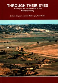
Book, Through Their Eyes : A Story of the Reclamation of the Rowsley Valley
This book contains a collection of articles written by landholders, local residents and members of corporate and volunteer organisations describing their roles in the restoration of Rowsley Valley. The historical scope of this book encompasses the geological and environmental history of the area prior to human habitation, occupation by the Wadawurrung people prior to European colonisation, and the colonial and post colonial eras. This introductory contextual background is complemented by the rest of the book which describes the various aspects of the environmental restoration of the Rowsley Valley from the latter part of the 20th century continuing to the present day.Printed foolscap size book. Softcover. 112 pages. Colour and black and white photos. Maps, figures, tables. Index. Publication details. Graham Simpson (Publisher, Bacchus Marsh, Victoria, 2021. Lead authors Graham Simpson, Jeanette McGonegal and Alan Morton.This book contains a collection of articles written by landholders, local residents and members of corporate and volunteer organisations describing their roles in the restoration of Rowsley Valley. The historical scope of this book encompasses the geological and environmental history of the area prior to human habitation, occupation by the Wadawurrung people prior to European colonisation, and the colonial and post colonial eras. This introductory contextual background is complemented by the rest of the book which describes the various aspects of the environmental restoration of the Rowsley Valley from the latter part of the 20th century continuing to the present day.environmental restoration projects, rowsley valley victoria environmental history, conservation of natural resources, aboriginal australians bacchus marsh region history, wadawurrung people history -
 The Beechworth Burke Museum
Geological specimen - Olivine Crystals, Unknown
Olivine is mostly found on the Earth's surface in igneous rocks that are dark-coloured. It is common at divergent plate boundaries and at warm spots, such as volcanic areas. It crystalises and forms during the cooling of magma. Olivine is used in refractory sand, bricks, and gemstones. Olivine has been found on a number of meteorites, which might have originated from large asteroids or the mantle of a now-destroyed planet. This olivine crystal is thought to originate from Mount Noorat, with speculation that it could have originated from Mount Shadwell. Mount Noorat is a dormant volcano cone located in the Newer Volcanics Province of Victoria. Mount Noorat belongs to the Kirrae Wuurong people, who used the Mount as a place for meetings and gatherings prior to European settlement. Contact was first made between European settlers and the Indigenous people in 1841. The Mount has mostly been used for cattle and sheep grazing. Mount Shadwell is a well-known source of olivine and is the highest of a gathering of volcanic cones. The New Volcanic Province is located in South East Australia and covers 15000 square kilometres. It contains 400 explosive vents and small shield volcanoes. The last eruption is thought to have occurred 5000 years ago at Mount Gambier and Mount Schank. This olivine crystal has been identified as a volcanic bomb, which is a molten rock which was pushed out and ejected into the air when a volcano reupts. A rock needs to be larger than 65 mm in diameter to be classified as a volcanic bomb. This olivine volcanic bomb and its locality is historically and socially significant. The olivine was found in the Newer Volcanic Province, an area which contains over 400 dormant volcanoes. This olivine is one part of a volcanic bomb, which would have ejected when magma erupted out of a volcano. This specimen is part of a larger collection of geological and mineral specimens collected from around Australia (and some parts of the world) and donated to the Burke Museum between 1868-1880. A large percentage of these specimens were collected in Victoria as part of the Geological Survey of Victoria that begun in 1852 (in response to the Gold Rush) to study and map the geology of Victoria. Collecting geological specimens was an important part of mapping and understanding the scientific makeup of the earth. Many of these specimens were sent to research and collecting organisations across Australia, including the Burke Museum, to educate and encourage further study.A solid iron-magnesium silicate mineral with shades of green and brownburke museum, beechworth, geological, geological specimen, olivine, igneous rock, volcanic, gemstones, volcanic bomb, meteorites, asteroids, plantes, mount noorat, mount shadwell, indigenous, kirrae wuurong people, newer volcanics province, victoria, european settlement, eruption -
 The Beechworth Burke Museum
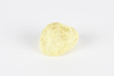
Geological specimen - Native Sulphur, unknown
Native Sulphur in its solid form is a yellow crystalline mineral that forms near volcanic vents and fumaroles where it is the solid form of hot gases. It is also frequently found in the subsurface as a by-product of sulphide ore mineralization. In all its forms, sulphur is one of the most commonly occurring minerals on the planet, especially in natural gases, and is key to the make-up of a range of other minerals. It is essential to continuing life on earth, and was used in ancient societies as part of medical care, religious rites, and entertainment, and was key to the invention of gunpowder by the Chinese. Native Sulphur in its solid form is a yellow crystalline mineral that forms near volcanic vents and fumaroles where it is the solid form of hot gases. It is also frequently found in the subsurface as a by-product of sulphide ore mineralization. In all its forms, sulphur is one of the most commonly occurring minerals on the planet, especially in natural gases, and is key to the make-up of a range of other minerals. It is essential to continuing life on earth and was used in ancient societies as part of medical care, religious rites, and entertainment, and was key to the invention of gunpowder by the Chinese. The exact site of extraction for this specimen is unknown, but it was probably collected in New Zealand in the 1850s. Sulphur is significant both for its historical and current uses, and for its nature as one of the most abundant minerals on the planet. Sulphur's importance comes both from its abundance and its role in ensuring survival, creating other minerals, and daily human life. This specimen is significant as representative of sulphur's solid properties. This specimen is part of a larger collection of geological and mineral specimens collected from around Australia (and some parts of the world) and donated to the Burke Museum between 1868-1880. A large percentage of these specimens were collected in Victoria as part of the Geological Survey of Victoria that begun in 1852 (in response to the Gold Rush) to study and map the geology of Victoria. Collecting geological specimens was an important part of mapping and understanding the scientific makeup of the earth. Many of these specimens were sent to research and collecting organisations across Australia, including the Burke Museum, to educate and encourage further study.A solid, small, crystalline mineral specimen that is largely bright yellow, with some darker spotting. geological specimen, geology, geology collection, burke museum, beechworth, sulphur, native sulphur, new zealand, native sulphur specimen, sulphur specimen -
 Bendigo Historical Society Inc.
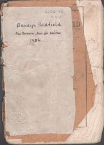
Booklet - Albert Richardson Collection: Bendigo Goldfield, MInes Department, Victoria 1936, 1936
Albert Richardson was an expert on the history of the Bendigo Goldfield. The Albert Richardson Park at Victoria Hill, is named in his honour. He was a prominent member of the Bendigo Historical Society. Fifty one page booklet. On front page: Bendigo Goldfield, issued by Geo Brown, Secretary for Mines, under the authority of The Hon. E.J. Hogan, M.L.A., Minister of Mines. Mines Department, Melbourne, Victoria, Australia, 1936.Content includes: historical information; recent development and future prospects, geology and lines of reef. Reef lines described are: Tysons, Lightning Hill, Hustlers, Derby, Paddy's Gully, Garden Gully, Deborah, Sheepshead, New Chum, Nell Gwynne, British and Foreign, Napoleon, Lancashire, Carshalton, Thistle, Christmas and Birds. On front cover 'Bendigo Goldfield, Geo Brown, Sec. for Mines, 1936' written in black pen. On first page 'A.Richardson, 29 Harrison Street, Bendigo' The booklet is annotated throughout by Albert Richardson, for example, the mines along the New Chum Line are further described with their date of formation, sill heights and area of claim.albert richardson, gold mining, goldfield, reef lines, 1936 -
 The Beechworth Burke Museum
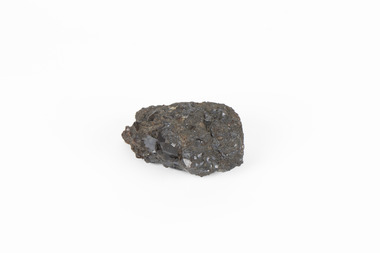
Geological specimen - Garnet crystals in galena, Unknown
Majority of Galena in Australia is found in hydrothermal deposits emplaced around 1680 million years ago which have been heavily metamorphosed. Galena is the natural mineral form of lead sulfaide. It occurs generally as fine to large crystals due to syntectonic remobilization at low temperatures and moves to a suitable location. The colour is a shining lead and silvery gray with high specific gravity between 7.2 and 7.6 gms/cm3 and contains 86.6 lead sulfaide in its purest form. Its cyrstal system is cubic with perfect cleavages, and contract penetration and lamellar twinning. This particular specimen is from the Broken Hill mine, it is one of the largest lead mines located in Western New South Wales and still has ore reserves amounting to 20.9 million tonnes of ore grading of 7.4% lead, 9.4% zinc, and 61.5 million oz of Silver. Throughout its history, it has produced over 200 million tonnes of ore throughout its 127 years of mining history dating back to 1885. Galena mineral ore found in Australia is considered rare, as it is only currently found in the Broken Hill Mine of Western New South Wales. It represents heritage value through the systematic collecting of the geological surveyers in Victoria and Australia during the early to late 19th Century. The fact that it is only found in one mining area of Australia, shows that this specimen is rare for examples of Australian Galena. This mineral specimen is one part to a larger collection, aquistion, and distribution of Garnet in Galena around Australia and parts of the world and donated to the Burke Museum between 1860-1880. While this specimen was not found by the Victorian Geological Survey, it shows the historical need for mapping geological areas around the Gold Rush region to further identify areas of precious metal and gem aquisition. Additionally, collecting these specimens was an important part of mapping the scientific make up of the earth's surface. Many were sent to institutions for further contribution to research and scientific knowledge of the specimens. A solid coin-sized lead and zinc sulphaide and zinc silicate ore mineral in shades of black and red with shiny black points. GARNET CRYSTALS in / GALENA (lead sulphide), / SPALERITE (zinc sulphide), / WILLEMITE (zinc silicate) ore. / Locality: Broken Hill, NSWburke museum, #beechworth, indigo shire, beechworth museum, geological, geological specimen, mineral, galena, galena quartz, broken hill mine, broken hill, nsw -
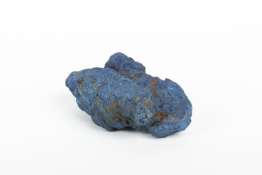 The Beechworth Burke Museum
Geological specimen - Azurite, Unknown
Azurite is a secondary copper mineral made by the weathering of copper sulphide ore deposits. Azurite is formed from copper, carbon, oxygen and hydrogen. There are over 45 forms of azurite that are more well-known, however over 100 forms have been found. Azurite is also commonly found together with Malachite, and Azurite is often psuedomorphed to Malachite. This specimen was found at the Great Cobar Copper Mine in New South Wales, which was founded in 1870. At the time it was one of the largest mining operations in the world. It was the largest copper mine in Australia and housed the southern hemisphere’s tallest chimney stack. The international price of copper collapsed at the end of World War 1 which led to the closure of the Great Cobar Mine on March 16th 1919. A year later on March 10th 1920 an underground fire in the CSA (Cornish, Scottish, Australian) mine started and burned for 16 years. The closure of the mine and the fire left thousands jobless and many people left the area. These were factors in Cobar facing a long stretch of poverty, until a boom in the 1960s led to the reopening of the mine. The mine still operates today, obtained by Metals Acquisition Limited in June 2023. Azurite is considered an uncommon mineral. Named for its deep blue colour, azurite was historically used for pigment making and as a gemstone, despite its softness. This specimen was donated to the Burke Museum between 1868-1880 as part of a larger collection of geological and mineral specimens. Many of the specimens in this collection were obtained as part of the Geological Survey of Victoria, which started in 1852. The Survey aimed to map the scientific makeup of the earth.A solid copper mineral with shades of darker blues almost covering it.burke museum, beechworth, indigo shire, beechworth museum, geological, geological specimen, mineralogy, cobar mines, great cobar copper mine, cobar mining, new south wales, azurite, azurite specimen