Showing 9408 items matching "hobsons-bay"
-
 Mission to Seafarers Victoria
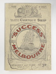
Book - Catalogue and Guide, Facsimile, Pryor Publications, The Famous Australian Convict Ship: "Success" Melbourne
non-fictionconvict ships, success -
 Port Melbourne Historical & Preservation Society
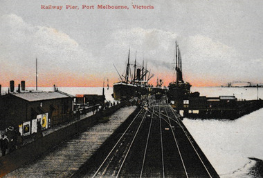
Postcard, W.T.P, Railway Pier, Melbourne, Victoria, c. 1900
Railway Pier opened in 1852 with the building of the Hobson's Bay Railway linking the city to Port Melbourne. In 1923 in was re-built as Station Pier.Postcard of Railway Pier with shed on left in front of 2 ships . A 4 masted ship lies on the opposite side below the Finger Pier.Cr L S Turnerpiers and wharves - railway pier, transport - shipping -
 Port Melbourne Historical & Preservation Society
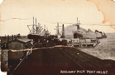
Postcard, Railway Pier, Melbourne, Victoria, c. 1900
Railway Pier opened in 1852 with the building of the Hobson's Bay Railway linking the city to Port Melbourne. In 1923 in was re-built as Station Pier.Sepia postcard of Railway Pier with shed on left in front of 2 ships . A sailing ship lies on the opposite side below the Finger Pier. A steamer being towed away from the pier by a tug .piers and wharves - railway pier, transport - shipping -
 Port Melbourne Historical & Preservation Society
Photograph, Railway Pier, Melbourne, Victoria, c. 1900
Railway Pier opened in 1852 with the building of the Hobson's Bay Railway linking the city to Port Melbourne. In 1923 in was re-built as Station Pier.Sepia postcard of Railway Pier with shed on left in front of 2 ships . A sailing ship lies on the opposite side below the Finger Pier. A steamer being towed away from the pier by a tug .piers and wharves - railway pier, transport - shipping -
 Phillip Island and District Historical Society Inc.
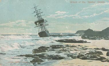
Photograph - Post Card, 1906
The "Speke" was a three masted steel ship built in Wales 1891 - the second largest at the time. The ship drifted broadside on to a reef to the east of Kitty Miller Bay on the 22nd February 1906 while on route from Peru via Sydney to Geelong in ballast to pick up wheat. Coloured postcard of the Wreck of the "Speke" near Kitty Miller Bay, Phillip Island.Wreck of the Speke," Cowes. Robb Bros. Cowes. On back: A letter from Miss Palmer's niece, Elsie with general family information. Sent on the 24/11/1907wreck of the speke, kitty miller bay phillip island, robb bros cowes phillip island, joan wilson -
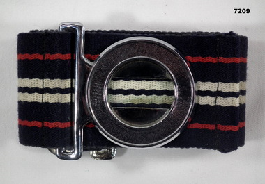 Bendigo Military Museum
Uniform - BELT, RACT, Hobson & Son
Part of the Kevin John Herdman, No. 397661, Collection. See Catalogue No. 5942P for details of his service record.Royal Australian Corps of Transport stable belt with two red and two white stripes on a navy blue background running the length of it. The belt has a chromed metal locket-style buckle and slide adjustment. Centre of buckle is embossed with an eight pointed star behind a Queen's Crown.Stamped on the back of buckle: "HOBSON & SON, LONDON"uniform, stable belt, royal australian corps of transport, kevin john herdman -
Moorabbin Air Museum
Book (Item) - Aeroplane Maintenance And Operation Series , Volume 1 , Carburettors (Part1)
Dealing with the maintenance and repair of the more popular types of Hobson aero carburettors with a chapter dealing with Hobson induction pressure (boost) control. -
Port Melbourne Historical & Preservation Society
Document - CD-ROM, Shipping Intelligence Hobsons Bay, Charles Lewis, 2013
Produced by Charles Lewistwo CDs- Shipping Intelligence Hobsons Bay. Excel files by Charles Lewis RHSV. .01 - Preamble and explanatory notes Table 1 - Ships 1871. Alphabetical. Table 2 Ships 1871. .02 Table 1 Passengers listed by ship. Table 2 Notable passengerstransport - shipping, hobson's bay, charles lewis -
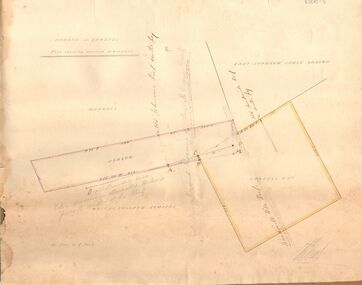 Bendigo Historical Society Inc.
Document - MARKS COLLECTION: HOBSON AND LANSELL PLANS SHOWING LAND IN DISPUTE
Plan, hand drawn, showing Hobson and Lansell plan 'shewing ground in dispute' On plan East Johnson Lease Ground, Hobson and Lansell land in between, West of England company on bottom of plan.bendigo, mining, hobson and lansell -
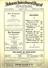 Bendigo Historical Society Inc.
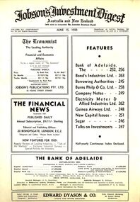
Book - HOBSONS INVESTMENT DIGEST, August 15th 1939
Hobsons Investment Digest of Australia and New Zealand August, 15th 1939.book, magazine, investment -
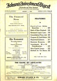 Bendigo Historical Society Inc.
Book - HOBSONS INVESTMENT DIGEST, August 1st, 1939
Hobsons Investment Digest of Australia and New Zealand August,1st 1939.book, magazine, investment -
 Bendigo Historical Society Inc.
Book - HOBSONS INVESTMENT DIGEST, June 15th, 1939
Hobsons Investment Digest of Australia and New Zealand June, 15th 1939.book, magazine, investment -
 Warrnambool and District Historical Society Inc.
Print - Lady Bay & Jetty
This photograph shows Lady Bay and Lake Pertobe in the late 1930s or early 1940s. This is before Lake Pertobe was developed in the 1970s as a recreation area and when ships were still anchoring at the Breakwater. This is a print of a photograph and its interest lies only in the fact that it is nicely framed and is suitable for hanging. It shows the foreshore over 70 years ago so is of historical interest. This is a print of a colour photograph of Lake Pertobe and Lady Bay in a gilt-edged wooden frame with a linen cloth insert. On back of frame – ‘Frame -Right, 98 Fairy Street, Warrnambool 3280’ (telephone number not decipherable)warrnambool, lady bay -
 Glenelg Shire Council Cultural Collection
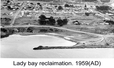
Photograph - Photograph - Lady Bay Reclamation: Aerial view looking West showing dumping of quarry overburden, 1959
Port of Portland Authority archivesFront: (no inscriptions) Back: 1959/ Lady Bay Reclamation/ Aerial view looking West showing dumping of/ Quarry overburden (black pen, upper left)port of portland archives, lady bay, reclamation, 1960s -
Port Melbourne Historical & Preservation Society
Document - Envelope, 125th Anniversary of Railways in Australia, Australia Post, 1979
Buff envelope headed "125th Anniversary of Railways in Australia" dated 16th September 1979. Red seal with embossing "Melbourne and Hobson's Bay"; also coloured printed stamp with brown and green engine - Australia 20c ; plus two black and white stamps ; information in red printing on the backtransport - railways, celebrations fetes and exhibitions, melbourne and hobson's bay railway company -
 Phillip Island and District Historical Society Inc.
Photograph, 1978/9
The Homestead was probably built about 1872 when Samuel Amess became the owner of Churchill Island. A large weatherboard construction with bay windows and corrugated iron roofing.Coloured photograph showing the homestead on Churchill Island. Bay windowed rooms projecting forward on either side of the verandah. Not the sundial in the foreground.local history, photographs, buildings - historical, rural industry, coloured photograph, john cook, churchill island -
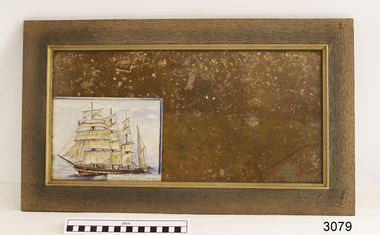 Flagstaff Hill Maritime Museum and Village
Decorative object - Wall Hanging, c. 1908
The unusual beautiful green American slate roofing tile used in this wall hanging was recovered from the shipwrecked Falls of Halladale. The iron-hulled, four-masted barque, the Falls of Halladale, was a bulk carrier of general cargo. She left New York in August 1908 on her way to Melbourne and Sydney. In her hold, along with 56,763 tiles of unusual beautiful green American slates (roofing tiles), 5,673 coils of barbed wire, 600 stoves, 500 sewing machines, 6500 gallons of oil, 14400 gallons of benzene, and many other manufactured items, were 117 cases of crockery and glassware. Three months later and close to her destination, a navigational error caused the Falls of Halladale to be wrecked on a reef off the Peterborough headland at 3 am on the morning of the 15th of November, 1908. The captain and 29 crew members all survived, but her valuable cargo was largely lost, despite two salvage attempts in 1908-09 and 1910. ABOUT THE ‘FALLS OF HALLADALE’ (1886 - 1908) Built: in1886 by Russell & Co., Greenock shipyards, River Clyde, Scotland, UK. The company was founded in 1870 (or 1873) as a partnership between Joseph Russell (1834-1917), Anderson Rodger and William Todd Lithgow. During the period 1882-92 Russell & Co., they standardised designs, which sped up their building process so much that they were able to build 271 ships over that time. In 1886 they introduced a 3000 ton class of sailing vessel with auxiliary engines and brace halyard winches. In 1890 they broke the world output record. Owner: Falls Line, Wright, Breakenridge & Co, 111 Union Street, Glasgow, Scotland. Configuration: Four masted sailing ship; iron-hulled barque; iron masts, wire rigging, fore & aft lifting bridges. Size: Length 83.87m x Breadth 12.6m x Depth 7.23m, Gross tonnage 2085 ton Wrecked: the night of 14th November 1908, Curdies Inlet, Peterborough south west Victoria Crew: 29 The Falls of Halladale was a four-masted sailing ship built-in 1886 in Glasgow, Scotland, for the long-distance cargo trade and was mostly used for Pacific grain trade. She was owned by Wright, Breakenridge & Co of Glasgow and was one of several Falls Line ships, all of which were named after waterfalls in Scotland. The lines flag was of red, blue and white vertical stripes. The Falls of Halladale had a sturdy construction built to carry maximum cargo and able to maintain full sail in heavy gales, one of the last of the ‘windjammers’ that sailed the Trade Route. She and her sister ship, the Falls of Garry, were the first ships in the world to include fore and aft lifting bridges. Previous to this, heavily loaded vessels could have heavy seas break along the full length of the deck, causing serious injury or even death to those on deck. The new, raised catwalk-type decking allowed the crew to move above the deck stormy conditions. This idea is still used today on the most modern tankers and cargo vessels and has proved to be an important step forward in the safety of men at sea. On 4th August 1908, with new sails, 29 crew, and 2800 tons of cargo, the Falls of Halladale left New York, bound for Melbourne and Sydney via the Cape of Good Hope. The cargo on board was valued at £35,000 and included 56,763 tiles of American slate roofing tiles (roof slates), 5,673 coils of barbed wire, 600 stoves, 500 sewing machines, 6,500 gallons of oil, 14,400 gallons of benzene, plumbing iron, 117 cases of crockery and glassware and many other manufactured items. The Falls of Halladale had been at sail for 102 days when, at 3 am on the night of 14th November 1908, under full sail in calm seas with a six knots breeze behind and misleading fog along the coast, the great vessel rose upon an ocean swell and settled on top of a submerged reef near Peterborough on south-west Victoria’s coast. The ship was jammed on the rocks and began filling with water. The crew launched the two lifeboats and all 29 crew landed safely on the beach over 4 miles away at the Bay of Islands. The postmistress at Peterborough, who kept a watch for vessels in distress, saw the stranding and sent out an alert to the local people. A rescue party went to the aid of the sailors and the Port Campbell rocket crew was dispatched, but the crew had all managed to reach shore safely by the time help arrived. The ship stayed in full sail on the rocky shelf for nearly two months, attracting hundreds of sightseers who watched her slowly disintegrate until the pounding seas and dynamiting by salvagers finally broke her back, and her remains disappeared back into deeper water. The valuable cargo was largely lost, despite two salvage attempts in 1908-09 and 1910. Further salvage operations were made from 1974-1986, during which time 22,000 slate tiles were recovered with the help of 14 oil drums to float them, plus personal artefacts, ship fittings, reams of paper and other items. The Court of Marine Inquiry in Melbourne ruled that the foundering of the ship was entirely due to Captain David Wood Thomson’s navigational error, not too technical failure of the Clyde-built ship. The shipwreck is a popular site for divers, about 300m offshore and in 3 – 15m of water. Some of the original cargo can be seen at the site, including pieces of roof slate and coils of barbed wire.The Falls of Halladale shipwreck is listed on the Victorian Heritage Register (No. S255). She was one of the last ships to sail the Trade Routes. She is one of the first vessels to have fore and aft lifting bridges. The Falls of Halladale is an example of the remains of an International Cargo Ship and also represents aspects of Victoria’s shipping industry. The wreck is protected as a Historic Shipwreck under the Commonwealth Historic Shipwrecks Act (1976).Wall hanging, framed slate salvaged from the wreck of Falls of Halladale. Slate is visible from both sides of TIMBER frame through glass. Coloured drawing of Falls of Halladale is inserted under glass. Typed inscription " "FALLS OF HALLADALE" "Grounded, Nov 14th, at Wreck Point, Midway between Peterborough & Bay of Islands" Typed inscription " "FALLS OF HALLADALE" "Grounded, Nov 14th, at Wreck Point, Midway between Peterborough & Bay of Islands" falls of halladale, cargo, flagstaff hill, warrnambool, shipwrecked coast, flagstaff hill maritime museum, maritime museum, shipwreck coast, flagstaff hill maritime village, great ocean road, slate, slate tile, green american slates, building material, wreck point, peterborough, bay of islands, russell & co. -
Port Melbourne Historical & Preservation Society
Photograph - CD-ROM, various Port Melbourne images, Charles Nettleton, 1875 - 1911
Gives us a visual description of Bay Street and other highlights in the late 1800s to early 1900sCD of digitised images from late 1800s to early 1900s. Images are of Bay St, from the North East; the Freemasons Hotel; Corner Beach and Stokes Streetsnatural environment - beaches and foreshore, built environment - commercial, bay street, beach street, stokes street, charles nettleton, carlton ale, fosters lager beer, whittle, business and traders - hotels, freemason's tavern -
 Ithacan Historical Society
Photograph, Aerial photograph - Platrithia, Ithaca, c1970s
The photograph is an aerial view of the village of Platrithia in northern Ithaca, overlooking Afales Bay. The Taxiarchi Church is located at the top of the hill, around which the village is located.A discoloured landscape of an aerial view of Aphales Bay and Platrithia with the church of Taxiarches and the road which leads to Marmaka located on the other side of the mountain.aphales, villages -
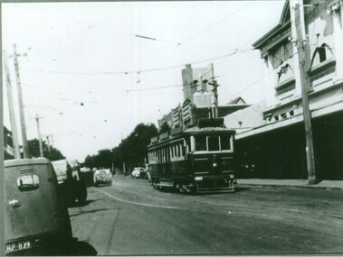
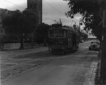 Melbourne Tram Museum
Photograph - VR tram 49 Bay Road Sandringham, 18-9-1956
Photo shows VR tram 49 in Bay Road, shortly after leaving Sandringham Station for Black Rock on 18-9-1956. The tram line closed on 5-11-1956Yields information the Sandringham to Black Rock tramway.Photograph - Black and White, printed on an A4 sheet.At one end of the print " #247 Bay Rd. No. 49 on down Sat. 18-9-1956"trams, tramways, tram 49, bay road, sandringham, black rock, vr trams -
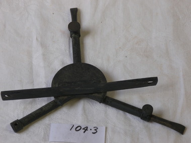 Flagstaff Hill Maritime Museum and Village
Instrument - Compass section, pre 1970
This compass section was recovered from the tug MELBOURNE, wrecked in Port Phillip Bay, Melbourne, around 1970.Tri-stand, metal, black, with hinged metal piece attached. Part of a binnacle or compass. Recovered from the tug "Melbourne" wrecked in Port Phillip Bay 1970. flagstaff hill, warrnambool, shipwrecked-coast, flagstaff-hill, flagstaff-hill-maritime-museum, maritime-museum, shipwreck-coast, flagstaff-hill-maritime-village, compass section, tug melbourne, shipwreck melbourne -
Glenelg Shire Council Cultural Collection
Photograph - Photograph - framed collection Ships and industrial estates in Portland, n.d
UnknownFramed collection of photographs in brown timber frame, under glass. 1. T.S.S. 'Ixion' First vessel berth K.S. Anderson (1959); 2. M.V. 'Athel Princess', first vessel to load bulk oats (1961); 3. Cresco fertiliser - Lady Bay; 4. Portland Bay; 5. T.S.S. 'Ixion'; 6. Harbur industrial estate - Cape Grant area; 7. Harbour construction 1957; 8. Cape Grant quarry 1957.Front: T.S.S. 'Ixion' First vessel berth K.S. Anderson (1959)/ M.V. 'Athel Princess', first vessel to load bulk oats (1961)/ Cresco fertiliser - Lady Bay; 4. Portland Bay/ T.S.S. 'Ixion'/ Harbur industrial estate - Cape Grant area/ Harbour construction 1957/ Cape Grant quarry 1957. Back: (no inscriptions) -
 Melbourne Tram Museum
Photograph - VR Sandringham tram in Bay Road, late 1940s, late 1940s
Photo shows either VR tram 48 or 49 (two man car) in Bay St Sandringham, just prior to turn into the tram depot. In the background is the Roxy Theatre and the spire of the All Souls Anglican Church. (The church spire has since been rebuilt). The VR Sandringham to Black Rock tramway closed on 5-11-1956. The print is a copy print of an original photograph.Shows a VR tram in Bay Road Sandringham.Black and white copy print on Kodak paper of a VR Sandringham tram in Bay Road. trams, tramways, vr trams, bay road, sandringam -
Port Melbourne Historical & Preservation Society
Plan - MMBW, Melbourne and Metropolitan Board of Works (MMBW), 1894 - 1895
Located on State Library Victoria (SLV) website by member Ray JelleyMelbourne Metropolitan Board of Works (MMBW) waste water (sewer) plans from 1894-95. Plan numbers 322, 331, 335, 564, 565, 575. Area bounded by Liardet St, East Esplanade, Foote St, Johns(t)on St and Hobsons Bay. Includes Gas works and Distillery.engineering - board of works, sewerage, mmbw, melbourne and metropolitan board of works -
 City of Kingston
Pamphlet - Colour, Fergusson & Mitchell Lith, Sandringham Rises, c. 1888
Sales plan for land in the suburb of Sandringham, bounded by Bluff Road, Bay Road and William Street, and incorporating Frances Street.The developing urban area of Highett (then called Sandringham) within the City of Kingston. This land sale pamphlet illustrates the subdivision of land within the municipality and the changing demographic of the district as new houses are constructed close to infrastructure.Colour pamphlet advertising for sale 35 lots in Sandringham Rises, Sandringham. Incorporates a map of the estate bordered by Bluff Road, Bay Road and William Street, including Frances Street.Handwritten in grey pencil next to the words 'THREE O'CLOCK': 1888 Handwritten in blue ben next to the words '& BUSINESS SITES': 1888land sales, sandringham, highett -
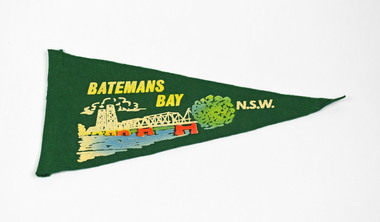 National Wool Museum
Pennant
BATEMANS BAY N.S.W. BATEMANS BAY n.s.w.batemans bay, new south wales -
 Coal Creek Community Park & Museum
Box, medicine, post 1930 after the new town of Leverkusen was named
Email from "Heike Dansard" Only two specimens remain in the Bayer archival collection. ref: email in 'Historical Information'.Oiled rectangular thick cardboard box with printed text on paper label on outside containing white crystalline powder. Top of box lifts off as lid.On box top : BAYER BAYER' as a cross with 'Y" as the centre set in a circle in a square margin. side 1. 'CYCLOFORM FabinFabriken orm (?) FRIEDR.BAYER & Co leverkusen a/ Coln a/ Rh pharmaceohscbe.......'. Side 2. ......'CYCLOFORM............BASYER BAYER Brevate et nom depose en Allamagne et dans la pluparet des autres pays industrials'. (translation : Patent name and deposited in Germany and most other industrial countries). Side 3. ' ......Weiderwerkaul..................in...........CYCLOFORM.........MARKE BAYER BAYER..................Name.....MARKE..................und.............ichgeschuzt.........ubrigon.anaesthetic -
Port Melbourne Historical & Preservation Society
Map - MHT General Plan showing Harbour improvements recommended Sir John Coode, Thomas Kell Lith, 1800s
Black and white map "Melbourne Harbour Trust, General Plan showing Harbour improvements, as recommended by Sir John Coode in his report of 17th February 1879" Showing proposed Coode canal and Sandridge, Hobson's Bay, North Williamstown, Footscray, the City, Emerald Hill and also the buildings of "Kitchen and Son" . (copy of original)industry, manufacturing, engineering department, borough of sandridge, engineering - canals and drainage, melbourne harbor trust - port of melbourne authority, j kitchen & sons pty ltd, sir john coode -
Port Melbourne Historical & Preservation Society
Document - Application for Planning Permit Rex Hotel, City of Port Phillip, 15 Oct 1996
Two A4 sheets of white paper giving details of the Notice of Application for Planning Permit for the Rex Hotel, 145 Bay Street, Port Melbourne. The application by Lex Carter Pty Ltd was for the use and development of the land for the purpose 'of a place of assembly(club)". The conditions of license are set out on the 2nd page. Rex Hotel 70 pokies Liquor License 9am - 1am Pencil sketch of layout of cnr Bay & Graham Streets.business and traders - hotels, rex hotel, city of port phillip -
Port Melbourne Historical & Preservation Society
Photograph - Corner Bay and Little Bay Streets, Port Melbourne, 26 Oct 2007
Photo of corner Bay and Little Bay Streetsbuilt environment, engineering - roads streets lanes and footpaths, edwin whiting