Showing 992 items
matching information map
-
 Southern Sherbrooke Historical Society Inc.
Information folder
Information folder pertaining to Birdsland. Contents:/map (copy), Shire of Yarra Ranges, Birdsland Reserve/flyer, Birdsland Then and Now, advertising talk at Belgrave Library, 9 Oct 2014birdsland -
Southern Sherbrooke Historical Society Inc.
Information Folder - geology of Dandenong Ranges
Information folder containing items pertaining to the geology of the Dandenong Ranges, including material prepared by Betty Hotchin for a talk to the Kallista Tourism course. Contents:-/typescript, re. basic features/photocopy, "The Dandenongs volcano and settlement in its great forest" by John Lundy-Clarke, published by Lilydale and District Historical Society/2 maps, Dandenong Ranges/List of reference materialdandenong ranges, geology of dandenong ranges -
Southern Sherbrooke Historical Society Inc.
Information folder - Auxilium College
Folder containing items pertaining to history of Auxilium College, Lysterfield. Contents: -"Tarella Quin" - article by Margaret McInnes, photocopy of Knox Historian Vol. 4 No.1 May 1992, pp. 42-65 -"Salesian serenity" - article by Scott Spits, photocopy of Knox News, Dec. 1, 1998, pg. 9 -"Auxilium College formerly known as Leasowes", information sheet prepared for Southern Sherbrooke H.S. Heritage Week tour, April 2002 -"Map to get from Auxiliun College to Mount Heatherley", map prepared for tour -article. "The Life & Works Of Tarella Quin". Knox Historical Journal, 2006 -photos, eleven, taken during our tour -
Southern Sherbrooke Historical Society Inc.
Information folder - Elvery family
Folder contains information pertaining to the Elvery family of Belgrave Heights. Contents: -Trifold A3 pamphlet, glossy paper, black, white and orange "The Lodge Just the perfect place to stay" c1990s advertisement flyer. -Map, hand-drawn with photos attached, "9 Hole Golf Course. Belgrave Heights - 1930-1943". Photocopy of large poster made by Betty DeCoite (original in map drawer) -Photocopy of photo, annotated in ink "Photo taken in Dandenongs - possibly Monbulk/the Patch? Photo supplied by David Elvery 2/6/99" -Photocopy of photo, Belgrave South Football Club team, probably 1945, plus list of names of team - from David Elvery 2/6/99 -printout, State Library of Victoria Multimedia Catalogue, Rose Series postcard of "Sunnyside Lodge" Lockwood, Belgrave South -copy of printed letter from David Elvery to CEO Shire of Yarra (sic) dated 8/6/99 re. vegetation on Mt Morton. Handwritten additions plus p'copy of Valentine Series postcard #3832 "Panorama From Mount Morton, Belgrave Heights" -p'copy of typed speech with annotations, by Rev. A.C. Beckingham at the opening of Lockwood -p'copy of photo, Harrison and Dalny Elvery and children David and Wendy c1936. Annotated by David Elvery 30/5/99 -printout, SLV Multimedia Catalogue, Rose Series postcard "Lockwood House" Lockwood, Belgrave South -p'copy, subdivision map "Lockwood Estate" lodged plan 6548 -p'copy, subdivision map Lockwood area, plan #6970 -A3 sheet, p'copies 6 postcards of Belgrave Heights -p'copy photo Elvery house, later "Sunnyside" and "Devon Lodge" annotated by David Elvery 2/6/99 -3 p'copied photos, Belgrave Heights, possibly Varney's butchers shop, possibly Whitlam residence. Annotated by David Elvery -2 p'copied photos, "Lockwood House", Golf links (Bill Woodfull, Principal of Upwey High School in photo), annotated David Elvery 2/6/99 -2 photos from David Elvery - moving Melbourne tram into "house" location at Lockwood, and bus "W. Dyke" unknown date and location. -3 photos from David Elvery - David on Gypsy (pony) Mt Morton Rd c1937, Wendy and David at entrance 37 Lockwood Rd c1942, David on Mack (horse) on golf links c1947 -Photo Arthur and Harrison Elvery, Lockwood House in background c1916 -photo Mrs Elvery, p'copy of postcard 26/3/20 addressed to "Dear Maud", mentions Charlie's wife and Laura (incomplete) -photo George Rae (Narre Warren North) Harold Allen and three other boys c1939 -6 photos, unlabelled (duplicates?) -photo Orchard Rd, Belgrave Heights -photo unlabelled, woman with child in pram, house in background (Lockwood?) -photo David Elvery on Gypsy as above -Rose postcard P2032 "Lockwood" Belgrave, Victoria -photo David Elvery on Mack (as above) -photo Wendy and David Elvery (as above) -2 photos, tram being moved (as above), football team -p'copy of Certificate of Title Vol.4562 Fol. 912336 dated 31/1/1922 - see list of names in folder -p'copy Memorial of Instruments (Land Title) dated 14/1/1914 -p'copy Cert. of Title Vol. 4562 Fol. 912335 dated 31/1/1922 -handwritten note, David Elvery to Susan Heywood-Downard -p'copy Memorial of Instruments dated 14/1/1914 -p'copy subdivision map, area bounded by Glen, Orchard, Avonside and Bay Rds, Belgrave Heights -p'copy Cert. of Title, Vol. 4810 Fol. 961945, dated 2/1/1924 -p'copy Cert. of Title, Vol. 4562 Fol. 912337, dated 31/1/1922 -Typed list of photo caption, relating to some of above photos -List of names and dates appearing on land title documents enclosed -Printout, Australian Dictionary Of Biography - Davies family - handwritten addition, marriage details, Arthur Elvery & Hannah Ord. -Printout - Family Search, Maria Louisa Davies, and family group, Ebenezer Davies & Ruth Bartlett. -letter to editor, Northern Star, Lismore, NSW, 11 Aug. 1923, Hannah Elvery, re. sport on Sunday -typescript - Elvery Family History, part of the "Alstonville" Elvery story, supplied by David H. Elvery 30th May 1999. From Bob Quincey.elvery family, lockwood house, belgrave heights, devon lodge -
Southern Sherbrooke Historical Society Inc.
Information folder - Local Government Amalgamations 1986, 1985 & 1986
Folder containing information pertaining to the Local Government amalgamations in Victoria in 1986. Contents: -copy of "Local Government Act 1958, appointment of a division of the local government commission and referral of proposals to the division", 8 pages and 6 explanatory maps -memo, dated 21 November 1985 from K. E. Matson, General Manager, Shire of Sherbrooke, to all councillors, re. local government commission and municipal restructure, 12 pages including map -letter, Warwick Heine, CEO, Shire of Lilydale to K. E. Matson, General Manager, Shire of Sherbrooke, dated 16 April 1986, re. local government restructure (2 copies) -booklet, "The Restructure of Local Government in Victoria: Options Paper Eastern Melbourne Segment", Local Government Commission June 1986, 24 pages -article "Residents to fight land deal", Knox-Sherbrooke News, 17 June1986, re. proposed annexation of part of Lysterfield by Berwick Council -article "Knox and Sherbooke align for the future", The Trader, 30 April 1986, re. alignment of common boundary -article "Boundary changes 'just a joke'", by Cheryl Critchley, Knox-Sherbrooke News, 6 May 1986 , re. Knox-Sherbrooke boundary alignment -article "Border clash worsens", by Peter Janky, Mountain District Free Press, 7 May 1986, re. Sherbrooke-Lilydale boundary changes -article "Ranges future is still clouded", The Free Press 30 April 1986, re. proposal to form a shire covering Dandenong Ranges -article "Sherbrooke wins first battle in restructuring", by Peter Janky, Free Press, 30 April 1986, re. ceding of forest areas by Knox to Sherbrooke.shire of sherbrooke, shire of lilydale, knox city council, berwick shire council -
Southern Sherbrooke Historical Society Inc.
Information folder - Fires 2003, 2003
Folder containing information pertaining to the 2003 Victorian, NSW & ACT bushfires. Contents: -3 photos of Omeo after the fires, by Dulcie Strahan -DSE/DPI Fire Update report dated 21st February -2 photos of fires in North-east Victoria by Andrew Aubert -3 Fire Overview maps, dated 24 January, 27 January (2 copies) and 16 February -leaflet, "Upper Murray Fires", community update, dated 12 January -copy of fire overview map, dated 16 February, with annotations -weather page, Border Mail, 8 Januarybushfires -
Southern Sherbrooke Historical Society Inc.
Information Folder - Len Jeffery
Information folder containing items pertaining to Len Jeffery. Contents: -handwritten notes by Elaine Cordell, dated 2017 -letter, Peter & Ruth Jeffery, to Phil Garland, dated 25 June 2011 -letter, Peter & June Jeffery to Elaine Cordell, dated 26 July 2011 -photocopy, A4, of photo featuring Thomas & Henry Jeffery -photocopies of death notice and short obituary, undated -photocopies (2), parish map (part) -photocopy part of allotments in Parish of Narree Worran with attached newspaper clipping -photocopy of hand-drawn map of blocks in Belgrave Heights -magazine "Yarra Valley & Ranges country life", Issue 7 Winter 2011, featuring article about Peter Jeffery, Len Jeffery's nephewlennox jeffrey, peter jeffery, belgrave heights progress association -
 Southern Sherbrooke Historical Society Inc.
Information folder - Lovers Walk, Belgrave
Folder containing information pertaining to the history of Lovers Walk. Contents: -5 maps showing Rights-Of_way between Belgrave and Mt Morton, Belgrave Heights, with path of Lovers Walk indicated -2 photos, reprints of Rose postcards, showing views of Lovers Walklovers walk, mt morton, walking tracks -
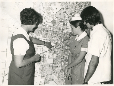 Royal District Nursing Service (now known as Bolton Clarke)
Photograph - Photograph, black and white, Barry Sutton, 01.05.1974
Sister Ellen Anderson is the Supervisor of the Royal District Nursing Service, (RDNS) Footscray Centre. She is wearing her RDNS uniform of a short sleeve white blouse under a royal blue V neck tunic style dress. Sr. Anderson is showing two Student nurses from Western General Hospital the map with the areas covered by Footscray Centre. The map had different colour pins to identify streets where patients lived who were currently receiving nursing care from RDNS Sisters working in these areas (districts).During their training, Student nurses from several hospitals either attended the Royal District Nursing Service (RDNS), Education Department, or, a RDNS Nurse Educator travelled to the appropriate hospital’s Education Department to educate the Trainees on District nursing through the RDNS Community Nursing Program. Following the lectures Students went to a RDNS Centre and each Student accompanied a Trained nurse (Sister) for a week observing and gaining knowledge of all facets of nursing care in the home. This gave them an insight into the home conditions and situations patients faced after discharge from hospital. During 1971 there were 584 Student nurses who received field experience with RDNS. From its inception as Melbourne District Nursing Society (MDNS), in 1885, their Trained nurses (Nurses) worked in specific areas, 'districts'. The first Nurse worked east and west, between Victoria Parade and Flinders Street and, north and south, between Spencer Street and Spring Street. When a second Nurse was employed they divided this area at Elizabeth Street so each Nurse could attend to patients in the same area giving continuity of care. As the Society expanded, becoming Melbourne District Nursing Service, then, with Royal patronage, Royal District Nursing Service (RDNS) many Centres were opened throughout the Melbourne Metropolitan area and outer suburbs. The District nurse's areas (districts) grew and were divided within Shire boundaries for e.g. Knox 1, Knox 2, Knox 3, Knox 4, within the area of the Shire of Knox. A map covering the Centre’s Districts was attached to a wall, and its different colour pins identified streets where patients lived who were currently receiving nursing care from the RDNS Trained nurses (Sisters) working in these areas (districts).On the left of this black and white photograph is Royal District Nursing Service (RDNS), Sister Ellen Anderson, who has short dark curly hair and is wearing her RDNS uniform of a short sleeve white blouse under a dark V neck tunic style frock. She is standing side-on, towards the right of the photograph, and with her left hand is pointing to an area on a large map attached to the wall in the background. To her right, is a Student nurse who is facing Sr. Anderson, and looking at the area on the map. Under her white nurses cap, she has her long dark hair drawn back, and is wearing her hospital uniform of a short sleeve checked dress with white collar and cuffs; a nursing watch is attached to its upper left; her hands are clasped in front of her. To her right, is a male Student nurse who has collar length straight dark hair, and is wearing white trousers and a short sleeve white top with pens in the left upper pocket. He is looking at the areas on the map.. Barry Sutton MA 77 informationroyal district nursing service, rdns, rdns education, rdns centre, rdns district map, sister ellen anderson -
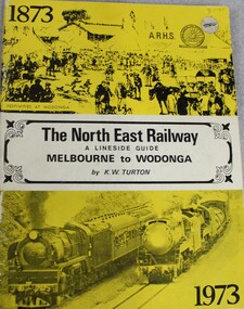 Wodonga & District Historical Society Inc
Book - The NORTH EAST RAILWAY Melbourne to Wodonga- A Lineside Guide, Keith W. Turton, 1973
A detailed history and description of the North East Rail Line, including information about each station and siding and relevant maps.non-fictionA detailed history and description of the North East Rail Line, including information about each station and siding and relevant maps.railway transport victoria, north east railway victoria, victoria railways, lineside rail guide -
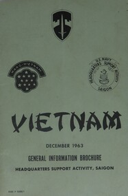 Diamond Valley Vietnam Veterans Sub-Branch
Booklet - n/a, General Information Guide, Vietnam, December 1963, 22/3/2009
Booklet detailed general information for US Forces in Vietnam and, often this information was imparted onto Australian Forces.Some elements of the General Information form the conditions under which Australian Forces lived and served whilst in Vietnam.Green light cardboard cover with black text and logos on front cover; a map showing Saigon and surrounds on back cover.Three logos: Military Assistance Command, Vietnam; MAAG-Vietnam; U.S. Navy, Headquarters Support Activity, Saigonvietnam, vietnam war, diamond valley vietnam veterans sub branch, us forces -
Tarnagulla History Archive
Folder - Waanyarra / Jones Creek, 1990s
Red binder containing information on Waanyarra & Jones Creek. Posters/flyers for 'Back To' reunions, map and names list for cemetery. Compiled by Donald Clark. -
Whitehorse Historical Society Inc.
Document, Andreas Fritsch, 1992
History and maps of the brick quarry opened by Andreas Fritsch in Nunawading in 1856.History and maps of the brick quarry opened by Andreas Fritsch in Nunawading in 1856. His quarry was between Burwood Road and Mahoneys Reserve, enclosed with a letter from Geoff Ford, historian and pottery collector to Mrs B. Gray. Information on history taken from Niall Brennan's 'History of Nunawading'.History and maps of the brick quarry opened by Andreas Fritsch in Nunawading in 1856. clay, fritsch, andreas, ford, geoff, gray, beryl, pottery -
Whitehorse Historical Society Inc.
Map, Dandenong Ranges Area, 1956
... Mitcham melbourne Map Map Dandenong Ranges Area. Sheet 1. Parts ...Sheet 1. Parts of Parishes: Nunawading, Warrandyte and Ringwood. Scale: 10 chains : 1 inch. Contour intervals marked and locations of buildings.Sheet 1. Parts of Parishes: Nunawading, Warrandyte and Ringwood. Scale: 10 chains : 1 inch. Contour intervals marked and locations of buildings. Compiled from aerial photographs and cadastral survey information.Sheet 1. Parts of Parishes: Nunawading, Warrandyte and Ringwood. Scale: 10 chains : 1 inch. Contour intervals marked and locations of buildings. maps, ringwood, mitcham, warrandyte -
Whitehorse Historical Society Inc.
Report, Robert Bethel, 1/06/1997
Photocopy of school assignments. Includes description of several local war memorials and an investigation into the record of Robert Bethel whose name appears on the Box Hill and Mitcham War Memorials although he was a Tasmanian. Bethel was killed at Gallipoli, information includes copies of Bethel's military record and correspondence with his parents, his family background and details of his brother, Wilfred Michael Bethel also killed in action at the Somme. Maps show his travels. Illustrations. Approx 42 pagesbethel, robert, world war, 1914-1918. battle of gallipoli, wilfred michael, world war 1914-1918. battle of the somme, war memorials -
Whitehorse Historical Society Inc.
Report, Charles William Gilbert Blake, 1/06/1997
Photocopy of school assignment. Includes information about a number of local war memorials and an investigation of Charles William Gilbert Blake whose name is on the Mitcham War Memorials. Blake enlisted in East Burwood. He trained in Egypt and was then sent to England where he died in hospital of an abscess in the brain. He is buried at the Tidworth Military Cemetery. Photographs. Maps. Approx 28 pagesblake, charles william gilbert, war memorials, world war, 1914 - 1918, tidworth military cemetery -
Whitehorse Historical Society Inc.
Pamphlet, Blackburn Lake Sanctuary, c2000
Description of the Blackburn Lake Sanctuary with a brief history, information about events held in the sanctuary and the role of the Blackburn Lake sanctuary Advisory Committee. Detailed map.Description of the Blackburn Lake Sanctuary with a brief history, information about events held in the sanctuary and the role of the Blackburn Lake sanctuary Advisory Committee. Detailed map.Description of the Blackburn Lake Sanctuary with a brief history, information about events held in the sanctuary and the role of the Blackburn Lake sanctuary Advisory Committee. Detailed map.blackburn lake, blackburn lake sanctuary advisory committee -
Whitehorse Historical Society Inc.
Map, M.M.B.W, c1962
Melbourne Metropolitan Area Base Map series sheet 235, covering part, Mitcham, Nunawading and Ringwood areas.Melbourne Metropolitan Area Base Map series sheet 235, covering part, Mitcham, Nunawading and Ringwood areas. Prepared by Department of Lands and Survey and Melbourne and Metropolitan Board of Works from State aerial Survey, June 1957 and Cadastral Survey information, August 1960. Scale 1:4,800.Melbourne Metropolitan Area Base Map series sheet 235, covering part, Mitcham, Nunawading and Ringwood areas. maps, mitcham, nunawading, ringwood, melbourne and metropolitan board of works, victoria. department of lands and survey -
Whitehorse Historical Society Inc.
Document - Report, Henry William Dowton, 1/06/1997
Luther College Year 10 History report on Henry William Dowton, a name on the Mitcham War Memorial. Includes material from Australian Archives and from the family. 'Dick' Dowton was from Gippsland and was killed at Pozieres during the Battle of the Somme on 25th July 1916. The report details visits to various War Memorials and the search for information. Also included is information from the Trafalgar Historical Society including correspondence to and from Dowton and between his parents and the army as they sought information about his death. Illustrations, maps, 64 pages.dowton, henry william;, world war, 1914-1918. battle of the somme, war memorials -
Whitehorse Historical Society Inc.
Document - Report, Frank Isaac White, 01/06/1997
Photocopy of a Luther Collage assignment on visits to war memorials and an investigation of Frank Isaac White, a name on the Mitcham War Memorial. White served in Egypt and France,. Maps show the route of his journeys including a period in hospital in England. Information is given about soldiers living conditions and his role as a artillery man. He was killed in Belgium on 20th September 1917 and buried in the Menin Road South Cematery at Ypres. Photographs of the cemetary are included and of his grave.white, frank isaac, menin road south military cemetry, ww1, war memorials -
Whitehorse Historical Society Inc.
Map, Melbourne Metropolitan Area Base Map, 1957?
Sheet 254 of part of the Municipality of Nunawading and part of the Parish of Nunawading, showing roads, block numbers, creeks and contours mostly south of Canterbury Road.Sheet 254 of part of the Municipality of Nunawading and part of the Parish of Nunawading, showing roads, block numbers, creeks and contours mostly south of Canterbury Road. Prep. from State Aerial and Cadastral survey information, August 1957. Scale: 400 ft = 1 inchSheet 254 of part of the Municipality of Nunawading and part of the Parish of Nunawading, showing roads, block numbers, creeks and contours mostly south of Canterbury Road. city of nunawading, cadastral -
 Whitehorse Historical Society Inc.
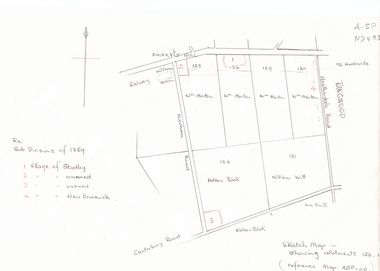
Document, Subdivisions 1859, nd
Sketch map of subdivisions of 1859.Sketch map of subdivisions of 1859. Allotment 126 and portions of 125, 126 and 130, including 'Village of Studley', 'Village of New Brunswick' and two unnamed. Information from Mr McComb, retired surveyor; sketch and notes. Areas near railway line east of Mitcham Station and North East corner of Canterbury and Mitcham Roads. Refer map A - SP 110.Sketch map of subdivisions of 1859.land subdivision, heatherdale road, mitcham, purches street, mitcham road, vermont, canterbury road, whitehorse road, brunswick road, creek road, centre road, studley village, new brunswick village -
 Whitehorse Historical Society Inc.
Document, Yarran Dheran, ?1985
Information brochure on development and features of Yarran Dheran Reserve, including map. Prepared by City of Nunawading Parks and Recreation Department, ?1985.yarran dheran, parks and reserves -
 Whitehorse Historical Society Inc.
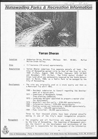
Book, The School Paper for Class 111 - Education Dept Vic, 1908 - 1909
According to an accompanying from donor, these school papers were used bt H.Tuck at Vermont State School -1918.This 'book' appears to be a series of journals or magazines bound together with a home made twisted cloth spine and hand stitched. Photo of peach blossom on front cover of issue for October, no. 141. Gothic Script Title. (see also History and Other Information)Several red ink scribbles similar to map markings on top left hand corner.books, school/educational -
 Whitehorse Historical Society Inc.
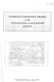
Pamphlet - Report, Church and community profile of the Nunawading and Blackburn region, 1/06/1997 12:00:00 AM
A report produced by Maroondah Presbytery of the Uniting ChurchA report produced by Maroondah Presbytery of the Uniting Church examining the state of the church in the Nunawading and Blackburn regions. Churches included are Mount Pleasant, Mountview, Nunawading, Parkmore, St Ninian's, The Avenue, and Vermont Uniting churches and the Nunawading District Young Adult Ministry. Statistical membership figures are given and compared with demographics of the district. Ministerial and other leadership resources are listed. Property details are listed as are community resources provided. Information on Strathdon Community is given. An appendix relates the amalgamation of the Mitcham Methodist and Presbyterian Churches to form Mountview Uniting Church. Another appendix relates a parable: 'Lying Offshore' by William Jones. A map shows the location of all local Uniting Churches. 20 pages.A report produced by Maroondah Presbytery of the Uniting Church mount pleasant uniting church, mountview uniting church, mitcham, nunawading uniting church, parkmore uniting church, forest hill, st ninians uniting church, blackburn south, vermont uniting church, uniting church. young adult ministry, nunawading district, strathdon community -
 Whitehorse Historical Society Inc.
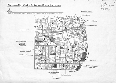
Map, Nunawading parks and recreation information, 1990 ?
... information Map of parks and reserves in the City of Nunawading, 199 ...Map of parks and reserves in the City of Nunawading, 199-?city of nunawading. parks and recreation department, parks and reserves -
 Whitehorse Historical Society Inc.
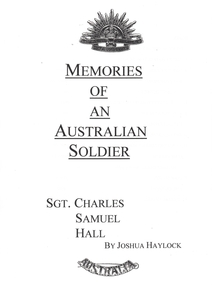
Photograph - School Project, Memories of an Australian Soldier, 1/06/1997 12:00:00 AM
Photocopy of Luther College Year 10 history project describing several war memorials and researching the story of Sergeant Charles Samuel Hall whose name appears on the Mitcham War Memorial. He served at Gallipoli and on the Western Front but contracted tuberculosis and died at the Australian Military Hospital, Harefield Park in Middlesex. The report includes information about tuberculosis and relates the disease to the conditions in Gallipoli and in France. A report on the Battle of Pozieres is included. 70p. Maps. Photographs.hall, charles samuel, world war 1914-1918. battle of poziers, war memorials -
 Whitehorse Historical Society Inc.
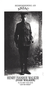
Article - School Project, Remembering an ANZAC, 1/06/1997 12:00:00 AM
Photocopy of Luther College Year 10 History assignment which describes several war memorials and researches the story of Henry Ivanhoe (Ivan) Walker whose name is on the Mitcham and Box Hill War Memorials.Photocopy of Luther College Year 10 History assignment which describes several war memorials and researches the story of Henry Ivanhoe (Ivan) Walker whose name is on the Mitcham and Box Hill War Memorials. He was killed by shellfire on the Western Front and his body never recovered. Copies of letters to and from his parents as they tried to find out information about his death are included. There is some information about his family and an interview with his sister Mrs Hazel Hall who provided some of his letters to his family. 65p Maps. Photographs.Photocopy of Luther College Year 10 History assignment which describes several war memorials and researches the story of Henry Ivanhoe (Ivan) Walker whose name is on the Mitcham and Box Hill War Memorials.walker, henry ivanhoe (ivan), walker family, war memorials, world war, 1914 - 1918 -
Whitehorse Historical Society Inc.
Map, Nunawading Planning Scheme, 7/06/1994 12:00:00 AM
Local Section maps 1 - 4 with index. Geographical information system land Information Branch. Scale 1:10,000 Shows zoning under planning scheme.Local Section maps 1 - 4 with index. Geographical information system land Information Branch. Scale 1:10,000 Shows zoning under planning scheme.Local Section maps 1 - 4 with index. Geographical information system land Information Branch. Scale 1:10,000 Shows zoning under planning scheme.blackburn, blackburn north, blackburn south, forest hill, heatherdale, maps, nunawading, vermont, vermont south, town planning, burwood east, laburnum -
Whitehorse Historical Society Inc.
Map, Dandenong Ranges area. Sheet 7, c1957
... and Cadastrial Survey information July 1956. maps mitcham vermont ...Detailed map covering area from Mitcham and Vermont to Ringwood and Heathmont.Detailed map covering area from Mitcham and Vermont to Ringwood and Heathmont. Shows streets, block boundaries, buildings, railway and creeks. Note says prepared from State Aerial Survey, April 1954 and Cadastrial Survey information July 1956.Detailed map covering area from Mitcham and Vermont to Ringwood and Heathmont. maps, mitcham, vermont, ringwood, heathmont