Showing 463 items
matching nautical instrument for measuring pitch or slope
-
 Eltham District Historical Society Inc
Document, Russell Yeoman, Tour of Historic Buildings and Locations, 1978
Self guided heritage tour information produced by the Shire of Eltham Historical Society for 1978 Eltham Community Festival of 36 locations each numbered on accompanying map. Locations and detail provided current to 1978: 1. ELTHAM SHOPPING CENTRE Whilst very little remains in the centre of historical importance, this area has interest as the "village" which developed over many years following the opening of the railway from Melbourne in 1902. Previously the shopping centre had been spread out over a long length of Main Road to the south. Shops have been continuously demolished or remodelled and the majority of buildings date from the 1950's or later. The recently erected Post Office replaced the "old" Post Office opened on the same site only in 1958. 2. WOOLWORTHS ELTHAM VILLAGE Part of the site of this modern shopping development was occupied by the former Eltham Shire Offices and Hall. The hall was paid for by public subscription whilst the Council raised a loan for the offices. The combined building was opened in 1941. It served as office and Council meeting place until 1965 and as the hall until its demolition in 1970. 3. ELTHAM WAR MEMORIAL The complex of buildings adjoining the present Shire Offices were financed by public subscription as a Memorial following World War II. Their construction and for many years their operation was organised by the now disbanded Eltham War Memorial Committee. The original buildings were the; Infant Welfare Centre, Children’s Library (now War Memorial Hall and Dental Clinic) and Kindergarten. In later years the Elderly Citizens Club was built at the rear. 4. ELTHAM SHIRE OFFICES These offices were opened in 1965 and extended in 1971 to provide additional office accommodation and the Eltham Library. They represent the last of a long line of offices and meeting places of the Eltham Shire Council and its predecessor the Eltham District Road Board. The building occupies the former site of Shillinglaw Cottage. The three tall cypress trees which stood in front of the Cottage have been retained as a feature of the office surrounds. 5. OUR LADY'S CHURCH AND SCHOOL The Catholic Church and School complex opposite the Shires Offices shows a number of stages in the development of Eltham township. The recently constructed church adjoins its predecessor (now the parish centre). Many years ago the Catholic Church was located opposite Wingrove Park and the present central site follows the northerly drift of the township. 6. SHILLINGLAW COTTAGE The Cottage was built in 1859 by George Stebbing, a local builder who was responsible for a number of other prominent buildings in the area. Its removal from the site of the Shire Offices and re-erection on the present site was financed by public subscription. It is built of handmade bricks laid in Flemish Bond with an unusual design featuring burnt "leader" bricks over the whole facade. The Cottage is occupied by Eltham Fleececrafts and will be open during the Festival and at other times during weekends. It is classified by the National Trust. 7. RAILWAY BRIDGE The timber trestle bridge over the Diamond Creek was built in 1901. Whilst all of its timbers have been replaced at various times over the years the only change to its character has been the addition of pylons and wiring for electric trains in 1923. It is one of very few similar bridges remaining in the metropolitan area. In 1976 a proposal to replace the bridge with an earth embankment and large culvert pipes was abandoned following community protests. The bridge, however, remains under threat because of the necessity for future deuplication of the railway line. 8. ELTHAM CENTPAL PARK The area between the railway and the creek has for many years been used as a park which included Eltham' s main football oval. The access road, Panther Place is named after Eltham's team playing in the Diamond Valley League. In recent years a large area extending to Bridge Street and locally known as the Town Park has been landscaped and added to the area. The excellent blending of the park with the natural landscape of the creek valley has earned a National Trust Landscape Classification. 9. OLD BAKERY On the southern corner of York Street and Main Road is an old house with a shop front which was for many years the local baker's shop. The brick bakery at the rear is of somewhat later vintage than the house. 10. BRIDGE STREET CUTTING Before reconstruction of Main Road this intersection had deep cutting embankments on all four corners, forming a distinctive feature of the entrance to Eltham. Roadworks and private development have levelled the land on the low side of the road. A memorial to the Eltham soldiers of World War I which was located at the north-western corner is now situated at the Eltham R.S.L. 11. HILLTOP MILK BAR For many years this was the site of the Eltham Post Office under the control of the Hunniford family and later their descendants the Burgoynes. It was transferred to this site in 1855, although at that time the building apparently fronted Bridge Str e et. The site contained Eltham's first telephone exchange. The post office was relocated in 1954 but the shop was operated until recently by the Burgoyne family who still own the surrounding land. 12. UNITING CHURCH and former C.B.A. BANK The former Methodist Church was built in 1880 by George Stebbing. The Sunday School extension was built in 1929 and there have been more recent extensions. The adjoining opportunity shop was built as a bank in 1874 and purchased by the Methodist Church in 1954. 13. R.S.L. HALL, TELEPHONE EXCHANGE These relatively recent buildings occupy the site of a row of shops forming part of the early ribbon of business development along Main Road. In front of the R.S.L. building is the World War I Memorial relocated from the corner of Bridge Street and Main Road. 14. ELTHAM COMMUNITY CENTRE Australia's first mudbrick "community building" was opened in April this year. Part of the site of the building was purchased in 1856 by Henry Dendy (of Brighton fame). At the rear of the land near the creek was a steam flour mill whilst Dendy's house was at the Main Road frontage of the land. His purchase totalled about 2 Ha (5 acres) and included land on the opposite side of Maria Street (Main Road). Dendy became a prominent member of the Eltham community and served one term as President of the Eltham District Road Board. In 1867 Dendy sold his land and business to William Ford of Malmsbury and shifted to Walhalla. The avenue of trees leading past the Community Centre to the creek may well have bordered the track to the mill. 15. ELTHAM HOTEL The original part of this hotel was built in 1927 following the burning of the former Watson's Eltham Hotel on the same site. The car park on the opposite side of Main Road was also the site of a hotel variously known over the years as; the Fountain of Friendship, the Fountain and the Evelyn Arms. As the Fountain of Friendship it was the first meeting place of the Eltham District Road Board in 1856. 16. ST. MARGARET'S CHURCH, PITT STREET In 1860 Henry Dendy was appointed Chairman of a committee to establish a church of England in Eltham. He donated part of his land in Pitt Street and in 1861 the church was opened. It was built by George Stebbing and remains in a well preserved state today. Th adjoining old vicarage is now named Dendy Hou se. A new mudbrick church hall is under construction on the site. The church and Dendy House are now listed on the Register of Historic Buildings. 17. NO. 86 PITT STREET Cottage built by George Stebbing and believed to be his home for some years in the 1850s. 18. LIVING AND LEARNING CENTRE The house was built in the 1850s with the kitchen at the front being added about 40 years later. By the creek below the house a number of early Eltham industries were located. These included a tannery and a brewery. 19. ELTHAM COURT HOUSE A Court of Petty Sessions was established in Eltham in 1858 and the present building dates from 1860. It is the oldest public building remaining in Eltham. In its early days the building was used as the meeting place and office of the Eltham District Road Board and as an overflow classroom for the local school. The Court House has been classified by the National Trust. The citation states that it is an example of the simple form of early brick Court House with gabled roof and porch. 20. LANDS DEPARTMENT OFFICE This building is the former police station and is probably of about the same age as the Court House. The lockup at the rear has been demolished but the old stables remain as garages. A licence was first granted for a police station at Eltham in 1856. 21. JARROLD COTTAGE The old Cottage opposite Dalton Street was formerly owned by the Jarrold family. Early records indicate that this was the building leased from the Jarrolds as a temporary police station prior to construction of the building on the corner of Brougham Street. The small building on the corner of the property was used as a boot repairer's shop. The elevated studio at the rear is a more recent construction by the present owners. 22. STATE SCHOOL RESIDENCE Erected in 1891 23. WINGROVE COTTAGE This building fills an important place in the history of Eltham and is now used as a medical clinic. It was built in 1858 for Charles S. Wingrove who was Secretary to the Eltham District Road Board and Shire Council from 1858 to 1904. During part of this period he was also Shire Engineer and was Secretary to the Heidelberg Road Board. The house was used as the office of the Board and Council for many years. Wingrove is buried in the cemetery at St. Helena. 24. WINGROVE PARK The parkland opposite Wingrove Cottage has been named after Charles Wingrove. The old Manna Gums are an outstanding feature of the park. 25. ELTHAM FRI.MARY SCHOOL NO. 209 The school first opened in the slab building in 1855 and operated from the present site since 1857. The oldest part of the present school is the stone building erected in 1876. The first school teacher, David Clark remained at the school until 1888. This school is the government township and has always been known as the Eltham School. An earlier school (no.371) known as Little Eltham School operated in Swan Street from 1853 to 1872. 26. "SHOESTRING" This house was built for school teacher David Clark. It has been extensively extended in recent years but the extensions do not detract from the character of the older part of the building. 27. ELTHAM CEMETERY The cemetery contains the graves of many of the district's pioneers . 28. MONTSALVAT This unique complex of buildings was commenced in 1935 by the late Justus Jorgensen and its development has extended over many years. Montsalvat has exerted a significant impact on Eltham The earth and stone construction of many of the buildings has influenced local architecture to a great extent and it has served as a "nerve centre" of the local artistic community. Montsalvat is open to the public for a small charge. 29. MAIN ROAD BRIDGE This location has been the main crossing of Diamond Creek since the earliest days of settlement. The present concrete bridge was erected in 1925 .and was preceded by a number of timber bridges. 30. ELTHAM LOWER PARK This park, being an unusually large flat area for Eltham, was originally the local racecourse. Horse races were held here from 1855 and the area was gazetted as a reserve for a racecourse and recreation reserve in 1857. The park is well known as a venue for school "bird days" and more recently as the site of the Diamond Valley Railway. This miniature railway features scale models of modern and old locomotives and rolling stock and has operated on this site since 1961 . Before that the railway operated at Chelsworth Park, Ivanhoe. 31. FALKINER HOUSE Frederick Falkiner was one of the earliest settlers in the Eltham township area and occupied a substantial leasehold prior to the first land sales. Early records show that Falkiner was the subject of a number of complaints from his neighbours but he has nevertheless been considered a prominent enough citizen to have a street named for him. This house was the home of Evelyn (Ely) Falkiner a member of Frederick's family. 32. WEST HOUSE Behind the large house on the hill is an early house built by the West family. This was relocated from a site near the front of the land by the present owner Mr. Fabbro. 33. FALKINER HOUSE This very old house is believed to have been the home of Frederick and may have been Eltham's first post office. Falkiner was the first post master for a short period. in 1854/55. 34. WITHERS HOUSE This house was the home of famous artist Walter Withers who shifted here from Heidelberg in 1903. 35. ELTHAM HIGH SCHOOL This school celebrated its jubilee this year, having commenced as the Eltham Higher Elementary School 50 years ago. 36. DIAMOND CREEK FOOTWAY If returning from the High School to the town centre the footpath by the bank of the Diamond Creek provides a pleasant route to finish your walk. The creek is a major tributary of the Yarra River. Together with its own major tributaries Arthurs Creek and Running Creek it commences on the southern slopes of the Dividing Range at Kinglake. It gives the name Diamond Valley to an area extending well beyond its actual drainage catchment.Recognition of the significance of various landmarks to the history of the Eltham community as of 1978‘shoestring’, 1978, bridge street cutting, burgoyne store, c.b.a. bank, diamond creek trail, eltham cemetery, eltham central park, eltham community centre, eltham community festival, eltham court house, eltham festival, eltham high school, eltham hotel, eltham lower park, eltham primary school, eltham railway trestle bridge, eltham shire offices, eltham shopping centre, eltham state school no. 209, eltham village, eltham war memorial, falkiner house, heritage trail, hilltop milk bar, jarrold cottage, lands department office, living, living and learning centre, main road bridge, montsalvat, old bakery, our eltham artistic recollections, our lady help of christian’s church, our lady help of christian’s primary school, pitt street, post office, r.s.l. hall, shillinglaw cottage, st margaret’s church, state school residence, stebbing cottage, telephone exchange, uniting church, west house, wingrove cottage, wingrove park, withers house, woolworths -
 The Beechworth Burke Museum
Postcard
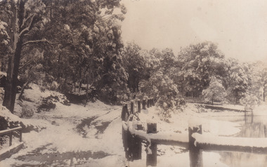
This postcard depicts Lake Kerferd during the winter season. With the photograph possibly been taken in the 1930s.The postcard holds Historic significance due to its connection to Beechworth and its Lake Kerford. It demonstrates the interactions between nature and colonialists, especially how the lake is surrounded by man made fencing and roads. It also shows that there was frequent human interaction with the area, due to the small snow slopes where vehicles would travel across. Black and white rectangular postcard, printed on card.Reverse: 56. / A03092 / 97.2205 POSTCARD / AUSTRALIA / KODAK CORRESPONDENCE / ADDRESS ONLY / KODAK / AUSTRALIA 84 - 134 - 1beechworth, lake, postcard, burke museum, black and white photograph, lake kerford -
 Federation University Historical Collection
Poster, The Red Sea Scorcher
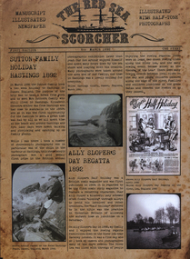
The Sutton Family were associated with Sutton's Music House, which was estanlished in Ballarat.A poster of the cover of the Red Sea Scorcher, which outlines the visit of Henry Sutton's family to Hastings, England, in 1922.henry sutton, elizabeth sutton, hastings, half-tone photographs, ally sloper's day regatta, arthur sutton -
 Kiewa Valley Historical Society
Gaiters Riding, Late 19th Century
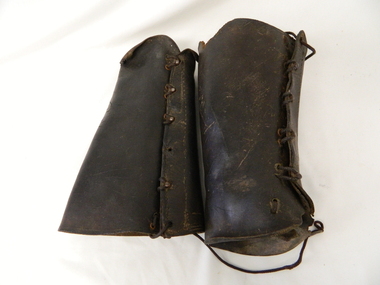
These gaiters where used circa 1800's to mid 1900's, by horse riders "cattle men" to protect their shins and long trousers against wear and tear. They were used rather than having expensive boots damaged. Gaiters were a lot easier to fasten and clean than boots. They were used in the Kiewa Valley and the High Plains grazing areas.These gaiters were part of a cattleman's "out fit". The Gaiters were easily cleaned and did away with expensive riding boots. They were used throughout the valley and high plains areas both by horse riders herding cattle and the recreational rider of both sexes. After the 1950s more recreational riders from Melbourne ventured onto the high plains and not so rugged mountain slopes. Small settlements such as Mount Beauty, Bogong village and Falls Creek provided a secure backdrop for short term horse back adventures. The increasing pressure of city life provided a greater flow of stressed out city dweller to find the peace and quiet that city life does not have. Horse riding preceded the modern trail bikes and other recreational vehicles of the late 1900s. Thick leather tapered gaiters with six metal Hooks and Leather lacing through metal eyelets. All bar two eyelets have a metal reinforced punch holes. Left gaiter missing most of lacing.horse, country, leather, gaiters, high, grazing, cattlemen, laces, studs -
 Monbulk RSL Sub Branch
Book, Cambridge University Press, A place to remember : a history of the Shrine of Remembrance, 2009
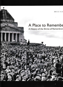
On the 11th of November 1934 over 300,000 people gathered on the slopes of Melbourne's Domain to witness the dedication of the Shrine. It was the largest state war memorial Australia would build and it commemorated the sacrifice of no fewer than 114,000 Victorians who served in the Great War. A Place to Remember charts the Shrine's history from the first fatalities of the Gallipoli landing to the present day. With deft hand and luminous style, Bruce Scates masterfully situates the Shrine in its larger physical, cultural and historical landscape. Archival image and first person vignette mesh with vivid prose to reveal The Shrine then and now; its changing patterns of meaning through the many conflicts in which Australians have fought and died, and the enduring significance of this grand memorial in the heart of Melbourne, for generations to come.Index, bibliography, notes, ill, maps, p.307.non-fictionOn the 11th of November 1934 over 300,000 people gathered on the slopes of Melbourne's Domain to witness the dedication of the Shrine. It was the largest state war memorial Australia would build and it commemorated the sacrifice of no fewer than 114,000 Victorians who served in the Great War. A Place to Remember charts the Shrine's history from the first fatalities of the Gallipoli landing to the present day. With deft hand and luminous style, Bruce Scates masterfully situates the Shrine in its larger physical, cultural and historical landscape. Archival image and first person vignette mesh with vivid prose to reveal The Shrine then and now; its changing patterns of meaning through the many conflicts in which Australians have fought and died, and the enduring significance of this grand memorial in the heart of Melbourne, for generations to come.war memorials - australia, shrine of remembrance - melbourne -
 Moorabbin Air Museum
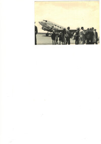
Photograph (Item) - Kyeema DC2
From: Clare Herscovitch The Kyeema airline crash occurred on 25 October 1938 when the Australian National Airways Douglas DC-2 Kyeema, tail number VH-UYC, flying from Adelaide to Melbourne, commenced final approach to Essendon Airport through heavy fog and crashed into the western slopes of Mount Dandenong, also known as Mount Corhanwarrabul, killing all 18 on board instantly.aircraft crash -
 Surrey Hills Historical Society Collection
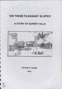
Book, On these pleasant slope's: a story of Surrey Hills, 2015
Sourced via conversations with those interested in Surrey Hills History. Including Alan Holt, Jack McLean, Frank Bamford, Jocelyn Hall. Includes: Topographical maps, first Elgar Survey. First Wesleyan Church in Surrey Hills. Bibliography on P.50 (last numbered page) Provides a chronological history of Surrey Hills. Includes: First settlers, location, early land sales, commerce and trade.Provides a chronological history of Surrey Hills. Includes: First settlers, location, early land sales, commerce and trade.Back of Title page: To the Surrey Hills Historical / Arthur E. Tonkinfreehold investment and banking company, windsor park estate, (mr) dennis delany, mont albert village, surrey hills - history, royal hotel, surrey hills, humberstone's hotel, chatham state school, holy trinity church, lydswood, lugano, (mr) john butler maling, (mr) john hanlon knipe, mont albert primary school, (mr) james sneddon, (mr) arthur tonkin -
 Surrey Hills Historical Society Collection
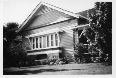
Digital photo, George L Coop, 688 Whitehorse Road, Mont Albert c 1953, c1953
This was the home of 3 generations of the Coop family: 1. Josephine and George Frank Coop (noted in Box Hill Rate Books for 1947-1954). 2. George Burton Coop (1906-1960) and his family. He was Assistant Chief Architect of Victoria in the Public Works Department (P.W.D.) George Burton Coop was born in c1906 in Williamstown, the son of Josephine Vistarini and George Frank Coop. He married Winifred Alice Trewartha in 1936 and they are listed in the electoral rolls at 688 Whitehorse Road in 1937. George died 3/4/1960, aged 54 years at Mont Albert. 3. George Burton and Alice Coop had 2 children: George Lister Coop - born St Georges Hospital, 8/10/1937 Alison - born c1945. The donor George Lister Coop informed that he initially attended Chatham State School because his first home was the Spanish Mission style flats at 346 Whitehorse Road, opposite Brenbeal Street, Balwyn. When his grandparents died, the family moved to 688 Whitehorse Road and he then attended Mont Albert Central School. The California bungalow style of housing was the dominant style of housing built in the interwar period through the northern parts of Surrey Hills and Mont Albert as formerly semi-rural land was subdivided for new housing. It was relatively inexpensive and affordable. In Australia the Californian bungalow drew upon elements that were popular across the United States from around 1910 to 1939. In Australia the style became popular from 1913. In Melbourne both timber and red brick were used as the main building material. Typically they are one or one and a half story houses and feature sloping roofs and eaves with unenclosed rafters and often a feature a dormer window (or an attic vent designed to look like one) over the main portion of the house. Decorative elements include wood shingles, part stucco rendered exteriors, brick, stone, rendered or a combination of these treatments to exterior chimneys and front porches supported by heavy timber, brick or stucco columns.A black & white photo taken at an angle of a Californian bungalow.californian bungalow, whitehorse road, george frank coop, (miss) josephine vistarini, (mrs) josephine coop, george burton coop, (miss) winifred trewartha, (mrs) winifred coop, george lister coop, alison coop -
 Surrey Hills Historical Society Collection
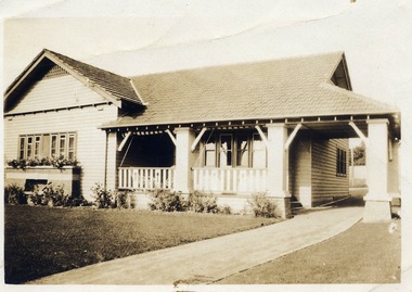
Digital photo, George L Coop, 688 Whitehorse Rd. Mont Albert c1950, c1950
This was the home of 3 generations of the Coop family: 1. Josephine and George Frank Coop (noted in Box Hill Rate Books for 1947-1954). 2. George Burton Coop (1906-1960) and his family. He was Assistant Chief Architect of Victoria in the Public Works Department (P.W.D.) George Burton Coop was born in c1906 in Williamstown, the son of Josephine Vistarini and George Frank Coop. He married Winifred Alice Trewartha in 1936 and they are listed in the electoral rolls at 688 Whitehorse Road in 1937. George died 3/4/1960, aged 54 years at Mont Albert. 3. George Burton and Alice Coop had 2 children: George Lister Coop - born St Georges Hospital, 8/10/1937 Alison - born c1945. The donor George Lister Coop informed that he initially attended Chatham State School because his first home was the Spanish Mission style flats at 346 Whitehorse Road, opposite Brenbeal Street, Balwyn. When his grandparents died, the family moved to 688 Whitehorse Road and he then attended Mont Albert Central School. The California bungalow style of housing was the dominant style of housing built in the interwar period through the northern parts of Surrey Hills and Mont Albert as formerly semi-rural land was subdivided for new housing. It was relatively inexpensive and affordable. In Australia the Californian bungalow drew upon elements that were popular across the United States from around 1910 to 1939. In Australia the style became popular from 1913. In Melbourne both timber and red brick were used as the main building material. Typically they are one or one and a half story houses and feature sloping roofs and eaves with unenclosed rafters and often a feature a dormer window (or an attic vent designed to look like one) over the main portion of the house. Decorative elements include wood shingles, part stucco rendered exteriors, brick, stone, rendered or a combination of these treatments to exterior chimneys and front porches supported by heavy timber, brick or stucco columns.A sepia photo taken at an angle from the street corner of the property. It is of a Californian bungalow with a driveway that extends through a carport, attached and roofed as part of the house, to the rear of the property. The veranda is accessed from under this covered area. The veranda and carport are supported by brick pillars and the veranda balustrades between are plain with an occasional wider feature panel. The front door is in shadow. There are rolled up striped canvas blinds on the veranda and at least 2 cane chairs. The main structure of the house is weatherboard with a terracotta tiled roof. There is a flower bed across the front of the house with an elevated brick flower box under the main window. There are no chimneys visible.californian bungalow, whitehorse road, george frank coop, (miss) josephine vistarini, (mrs) josephine coop, george burton coop, (miss) winifred trewartha, (mrs) winifred coop, george lister coop, alison coop -
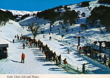 Falls Creek Historical Society
Postcard - Gully Chair Lift and Slopes, Falls Creek
These photographs were taken in and around Falls Creek by Samuel Keith Pearce and printed for him as a foldout postcard by NuColor Vue. The postcards state they were printed for S. K. Pearce Pty. Ltd of Tawonga and Mount Beauty. The Gully Chair Two Chair Lift began operation in 1964 and continued until 1981. In 1982 it was replaced with a Three Chair Lift.This collection of postcards and images is significant because they were commissioned by a highly successful businessman in Falls Creek, Victoria and showcase the Falls Creek Tourist Area.A coloured postcard of the Gully Chairlift which opened in 1964.falls creek village, postcards falls creek, s. k. pearce, gully chair lift -
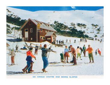 Falls Creek Historical Society
Postcard - Ski Hirage Centre and Ski Slopes
These photographs were taken in and around Falls Creek by Samuel Keith Pearce and printed for him as a foldout postcard by NuColor Vue. The postcards state they were printed for S. K. Pearce Pty. Ltd of Tawonga and Mount Beauty. Samuel Keith Pearce was born on 24 June 1917 in Armadale, Victoria. By the late 1940s he owned the Mt Beauty Supermarket, Newsagency, Drapery and Hardware store at Mount Beauty and also a store at Tawonga in partnership with his brother Gordon Cathew Pearce. For some time, they operated as Pearce Brothers. In the early 1960s Keith also opened a mini mart In Falls Creek. As well as being a keen photographer and an astute businessman, Keith Pearce was a well-known identity in the Kiewa Valley, making many contributions to the development of the area over a long period. This included serving as a member of the Bright Shire Council for many years. He worked hard to promote the interests of the Upper Kiewa Valley. As a sign of recognition and appreciation for his contribution to the community, the park opposite the grocery store in Mount Beauty was named the SK Pearce Gardens in his honour. Samuel Keith Pearce died on 7 July 1994 in Mount Beauty, VictoriaThis collection of postcards and image is significant because they were commissioned by a highly successful business in Falls Creek, Victoria.A postcard featuring an image of Winterhaven Lodge. In 1952 Orest “Ory” Freauf entered into a business partnership with Cecil Dobson, running the general store “Whitehaven” and Post Office at Falls Creek. They extended their business by adding accommodation turning Whitehaven into one of the best commercial lodges at Falls Creek.astra falls creek, falls creek accommodation, falls creek businesses -
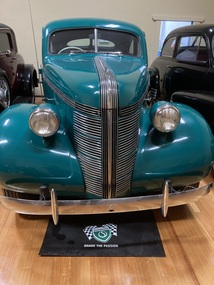 Trafalgar Holden Museum
Vehicle - 1939 Pontiac sloper, 1939
2 Door four seater Pontiac sedan Turquoise green in colourLong vertical chrome grille with Indian head insignia on bonnet fold.vehicle, pontiac, car -
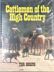 Falls Creek Historical Society
Book - Cattlemen of the High Country, Tor Holth with Jane Barnaby, 1980
The lives of the mountain cattlemen of Victoria's alpine country revolve around the annual muster held before the first snowfall of autumn, when they bring their cattle down to lower pastures for winter feeding, or consign them for auction at the annual calf sales in Omeo or Myrtleford. The close-knit communities of cattlemen share the common hazards of this mountainous region, enduring the snow and freezing conditions of winter and the threat of ravaging bushfires in summer, finding shelter from the harshness of the environment in little huts which they built from the rough materials available. But the dangers of steep slopes and rocky terrain, in which more than one drover has lost his life, hold no terrors for them. These tough and resourceful cattlemen are self-sufficient and skilful in everything they do, whether it is bushmanship, horse-riding, or telling tall tales. In this book their yarns and reminiscences about their mates, their horses and Hereford cattle, and their indispensable dogs, reveal a characteristic courage and endurance, and an indomitable sense of humour. This book provides an enduring record of a vanishing breed of Australians, folk heroes in their own right, whose lives form the basis of verse and legend.A book of 224 pages including maps, illustrations and photographic images, both black and white and colour. It includes a bibliography.The lives of the mountain cattlemen of Victoria's alpine country revolve around the annual muster held before the first snowfall of autumn, when they bring their cattle down to lower pastures for winter feeding, or consign them for auction at the annual calf sales in Omeo or Myrtleford. The close-knit communities of cattlemen share the common hazards of this mountainous region, enduring the snow and freezing conditions of winter and the threat of ravaging bushfires in summer, finding shelter from the harshness of the environment in little huts which they built from the rough materials available. But the dangers of steep slopes and rocky terrain, in which more than one drover has lost his life, hold no terrors for them. These tough and resourceful cattlemen are self-sufficient and skilful in everything they do, whether it is bushmanship, horse-riding, or telling tall tales. In this book their yarns and reminiscences about their mates, their horses and Hereford cattle, and their indispensable dogs, reveal a characteristic courage and endurance, and an indomitable sense of humour. This book provides an enduring record of a vanishing breed of Australians, folk heroes in their own right, whose lives form the basis of verse and legend.mountain cattlemen, cattle breeders victoria, australian cattlemen, bogong high plains history