Showing 578 items
matching operation equipment
-
 Parks Victoria - Port Campbell Rocket Shed
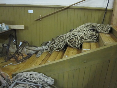
Rope
This rocket equipment has been used in various lifeboat and rocket stations on Victorian Coast. It is unclear if this is the original rocket equipment from Port Campbell. This equipment, if not original to the site, has been used in rescue operations and is identical to the equipment that was in use at Port Campbell from C.1890 onwardsRope, 1cm light line -
 Parks Victoria - Port Campbell Rocket Shed
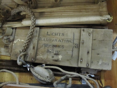
Box
This rocket equipment has been used in various lifeboat and rocket stations on Victorian Coast. It is unclear if this is the original rocket equipment from Port Campbell. This equipment, if not original to the site, has been used in rescue operations and is identical to the equipment that was in use at Port Campbell from C.1890 onwardsRectangular box with fitted lid. All wood. Two rope handles at each end. Inscribed on lid -"Lights Illuminating Wrecks. Mark-IV 3 . 4/7/1910"Inscribed on lid -"Lights Illuminating Wrecks. Mark-IV 3 . 4/7/1910" -
 Parks Victoria - Port Campbell Rocket Shed
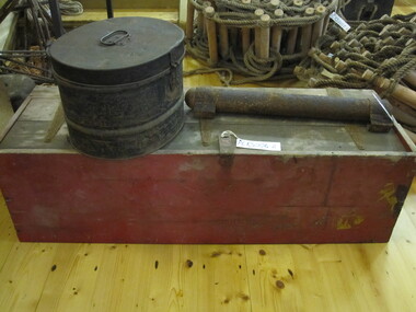
Box
Rocket equipment which has been used in various lifeboat and rocket stations on the Victorian Coast. It is unclear if this is the original rocket equipment from Port Campbell. This equipment, if not original has been used in rescue operations and is identical to the equipment that has been in use at Port Campbell from C.1890 onwards.Rope, 1cm light line in wooden box. Wooden rectangular box with lid held by 3 steel hinges. Red painted box, weathered. -
 Parks Victoria - Port Campbell Rocket Shed
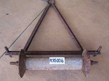
Rope roller
Rocket equipment which has been used in various lifeboat and rocket stations on the Victorian Coast. It is unclear if this is the original rocket equipment from Port Campbell. This equipment, if not original has been used in rescue operations and is identical to the equipment that has been in use at Port Campbell from C.1890 onwards.Rope roller, welded, cliff anchor. Steel A frame with eye at top of the A frame. Spindle on bottom for rope to move through. -
 Wodonga & District Historical Society Inc
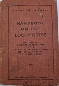
Manual - Handbook on the Locomotive 1952
This book aimed to provide information about how the best performance could be obtained from a locomotive. It provided knowledge about the construction of a locomotive and reasons for equipment provided in order to develop in engineman an appreciation of the machines of which they were in charge.A maroon coloured volume with black text including the title, brief outline of its purpose and publication date.fictionThis book aimed to provide information about how the best performance could be obtained from a locomotive. It provided knowledge about the construction of a locomotive and reasons for equipment provided in order to develop in engineman an appreciation of the machines of which they were in charge.vline training, railways victoria, operation of locomotives -
 Wodonga & District Historical Society Inc
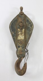
Functional object - Pulley, North East Region Water Authority, Wodonga
The pulley was used by the Wodonga Waterworks Trust and Sewerage Authority, which were established in 1897, and had the responsibility for providing Wodonga's drinking water and managing the wastewater. In 1923 a Wodonga Waterworks Trust referendum to provide funding for new infrastructure to supply more water of better quality to Wodonga was passed. This included building the Wodonga Water Tower and it was completed in 1924. It supplied water to Wodonga until 1959, when it was drained and decommissioned after the No 1 Basin on Huon Hill was completed in 1958. In 1983 the Wodonga Waterworks Trust and the Wodonga Sewerage Authority became part of the Wodonga Council. And by 1989 a filtration plant at Huon Hill was completed, which provided filtered water of improved quality to Wodonga, in accordance with the World Health Organisation’s guidelines. In 1994 the Kiewa Murray Region Water Authority took over the Wodonga Council’s water and wastewater operations, and then in 1999 the Kiewa Murray Region Water Authority combined with the Ovens Region Water Authority and became the North East Region Water Authority or NERWA. NERWA then became known as North East Water. The pulley has local significance due to its use by the Wodonga Waterworks Trust and Sewerage Authority, and donation from the North East Region Water Authority. It also has wider historical significance as an example of the equipment used in the early management of water in Victoria and Australia.Elongated ellipse-shaped iron pulley, painted black on the flat exterior surfaces. Considerable light brown dirt on the surface and traces of a silver coloured rectangular label on the central raised section on the front. The light brown surface dirt covers nearly the entire back surface. Piece of iron wire attached to the hook at the bottom of the pulley."Backwards R 6" on the central raised section on the back surface.wodonga waterworks trust, wodonga sewerage authority, wodonga water, pulleys, north east region water authority, north east water, n.e. water, nerwa -
 Wodonga & District Historical Society Inc
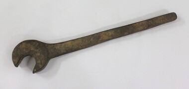
Tool - Large Spanner, North East Region Water Authority, Wodonga
The large wrench was used by the Wodonga Waterworks Trust and Sewerage Authority, which were established in 1897, and had the responsibility for providing Wodonga's drinking water and managing the wastewater. In 1923 a Wodonga Waterworks Trust referendum to provide funding for new infrastructure to supply more water of better quality to Wodonga was passed. This included building the Wodonga Water Tower and it was completed in 1924. It supplied water to Wodonga until 1959, when it was drained and decommissioned after the No 1 Basin on Huon Hill was completed in 1958. In 1983 the Wodonga Waterworks Trust and the Wodonga Sewerage Authority became part of the Wodonga Council. And by 1989 a filtration plant at Huon Hill was completed, which provided filtered water of improved quality to Wodonga, in accordance with the World Health Organisation’s guidelines. In 1994 the Kiewa Murray Region Water Authority took over the Wodonga Council’s water and wastewater operations, and then in 1999 the Kiewa Murray Region Water Authority combined with the Ovens Region Water Authority and became the North East Region Water Authority or NERWA. NERWA then became known as North East Water. The large spanner has local significance due to its use by the Wodonga Waterworks Trust and Sewerage Authority, and donation from the North East Region Water Authority. It also has wider historical significance as an example of the equipment used in the management of water in Victoria and Australia.Large cast iron spanner with some red/brown rust corrosion and light brown ingrained surface dirt.north east region water authority, nerwa, wodonga sewerage authority, north east water, n.e. water, wodonga, large spanners, spanner, wodonga waterworks trust -
 Wodonga & District Historical Society Inc
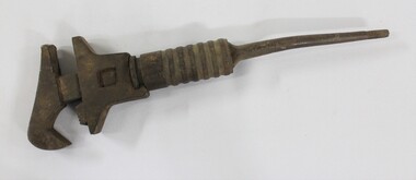
Tool - Shifter Wrench, North East Region Water Authority, Wodonga
The Shifter Wrench was used by the Wodonga Waterworks Trust and Sewerage Authority, which were established in 1897, and had the responsibility for providing Wodonga's drinking water and managing the wastewater. In 1923 a Wodonga Waterworks Trust referendum to provide funding for new infrastructure to supply more water of better quality to Wodonga was passed. This included building the Wodonga Water Tower and it was completed in 1924. It supplied water to Wodonga until 1959, when it was drained and decommissioned after the No 1 Basin on Huon Hill was completed in 1958. In 1983 the Wodonga Waterworks Trust and the Wodonga Sewerage Authority became part of the Wodonga Council. And by 1989 a filtration plant at Huon Hill was completed, which provided filtered water of improved quality to Wodonga, in accordance with the World Health Organisation’s guidelines. In 1994 the Kiewa Murray Region Water Authority took over the Wodonga Council’s water and wastewater operations, and then in 1999 the Kiewa Murray Region Water Authority combined with the Ovens Region Water Authority and became the North East Region Water Authority or NERWA. NERWA then became known as North East Water. The shifter wrench has local significance due to its use by the Wodonga Waterworks Trust and Sewerage Authority, and donation from the North East Region Water Authority. It also has wider historical significance as an example of the equipment used in the early management of water in Victoria and Australia.Large cast iron wrench with an adjustable grip and a circular turning mechanism at the top of a thin tapering handle. 2.6 cm thread on the end of the thin tapering handle. "GSP 23/15" on one side of the thin tapering handle.north east region water authority, nerwa, wodonga sewerage authority, north east water, n.e. water, wodonga, shifter wrench, wodonga waterworks trust -
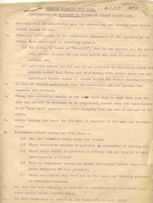 Ballarat Tramway Museum
Document - Instruction, Melbourne Electric Supply Co. (MESCo), " Geelong Tramways July 1924 Instructions to Motormen in Charge of Birney Safety Cars", 14/08/1924 12:00:00 AM
Demonstrates and instruction issued by the operator of the Geelong tramways (MESCo) at the time of the introduction of the new Birney Safety car, which allowed one man operation of trams. Gives details of the operating procedures of the tram.Two page typed foolscap document titled " Geelong Tramways July 1924 Instructions to Motormen in Charge of Birney Safety Cars" and dated 14-8-1924. Gives simple instructions on the Birney Safety Cars which were new to Geelong at the time. Includes notes electrical and air systems, procedures for running out, passenger capacity (max 60), testing equipment and running in. Original was pinned together in top left hand corner.In top right hand corner in ink "BTPS 401"trams, tramways, birney, geelong, instructions, safety -
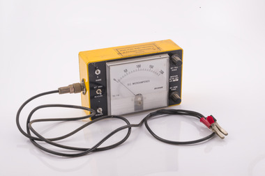 Forests Commission Retired Personnel Association (FCRPA)
FCV testing meter
After the 1939 bushfires, the Forests Commission invested heavily in a radically new communications network. After suffering some inevitable delays due to the War, radio VL3AA switched into full operation in October 1945 proudly beaming out 200 watts across the State. The communication systems were regarded at the time to be more technically advanced than the police and the military. These pioneering efforts were directed by Geoff Weste, and later technical experts like Rex Philpot, John Whitehead, Charlie Reisinger and many others who designed, built and repaired most of the radio equipment. There was a dedicated radio laboratory at Surrey Hills in Melbourne. The purpose and operation of this particular instrument is unknown.FCV testing meterMade in the radio laboratory of the Forests Commission Victoriaradio, forests commission victoria (fcv) -
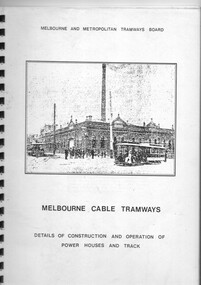 Melbourne Tram Museum
Document - Report, William R. Pollock, "Melbourne Cable Tramways - Details of Construction and Operation of the Power Houses and Track", 1930's?
Report titled "Melbourne Cable Tramways - Details of Construction and Operation of the Power Houses and Track". Compiled by William R. Pollock, MMTB Power House Superintendent. Report not dated, possibly late to mid 1930's. Consists of 12 pages of notes on the power house, cable operation and repairs, the grip and other aspects of operation, along with 26 appendices of drawings of equipment and parts of the cable tram system. Published by the MMTB. See also Reg Item 7895 for the drawings and 2129 re Mr. Pollock's employment.Yields information about the operation of the cable tram system in a report prepared for the MMTB prior to the closure of the cable tram system.Report - 54 pages, photocopied from an original, black comb bound with front clear plastic cover and rear manila cover.trams, tramways, cable trams, mmtb, grip tram, winding houses -
 Bendigo Military Museum
Photograph - 4th Field Survey Squadron deployed on Operation NERIGHT, Queensland & Northern Territory, 1989
This is a set of 19 photographs taken in 1989 during 4th Field Survey Squadron’s deployment on Operation NERIGHT 89 in Queensland and the Northern Territory. It was a two-part operation in 1989 with work conducted in the areas of Camooweal and Weipa. Part 1 was the field completion of topographic maps conducted near Camooweal QLD, along the Barkley Highway on the border between NT and QLD, from the 12th of September to the 20th of October 1989. A Bell Kiowa LOH helicopter from 162 Recce Sqn supported topographic field completion. Operation NERIGHT 89 Part 2 was the acquisition of mapping control by GPS field parties utilising Texas Instruments TI4100 Global Positioning System receivers around Weipa on Cape York Peninsula from the 22nd of September to the 22nd of October 1989. Part 2 Two Bell UH-1H Iroquois helicopters from RAAF’s 35 Squadron were principally used to deploy GPS field parties. Identification photography of control points was taken by air camera operators in AAAvn Pilatus Porter aircraft from 173 Gen Spt Sqn fitted with an RC10 aerial camera. The two parts of the operation were conducted concurrently. This is a set of 19 photographs taken in 1989 during 4th Field Survey Squadron’s deployment on Operation Neright in Queensland & the Northern Territory. The colour photographs are on 35mm negative film and are part of the Army Survey Regiment’s Collection. The photographs were scanned at 96 dpi. .1) to .3) - Photo, colour, 1989. En-route to areas of survey operations. .4) to .5) - Photo, colour, 1989. Unidentified personnel relax next to river/waterhole. .6) - Photo, colour, 1989. Two Bell UH-1H Iroquois helicopters from RAAF’s 35 SQN utilised in the movement of GPS parties. .7) to .9) - Photo, colour, 1989. Unidentified soldier practices repelling from a UH1H Iroquois helicopter. .10) - Photo, colour, 1989. Inside the cockpit of a UH1H Iroquois helicopter. .11) - Photo, colour, 1989. Field Party camp with GPS equipment in foreground. Unidentified soldier prepares a meal. .12) - Photo, colour, 1989. GPS antenna plumbed over a survey ground mark. Witness post on left. .13) & .14) - Photo, colour, 1989. Unknown Cape York Peninsula beaches. .15) & .16) - Photo, colour, 1989. Dramatic fire next to base camp. .17) - Photo, colour, 1989. Aboriginal rock art at unknown location. .18) - Photo, colour, 1989. Aboriginal rock art at unknown location. L to R: unidentified, SPR Andrew Quin. .19) - Photo, colour, 1989. Aboriginal rock art at unknown location. LT Chris Topovsek..1P to .19P – There are no personnel identified. ‘1989 OP NERIGHT’ annotated on negative sleeve.royal australian survey corps, rasvy, 4 fd svy sqn, op neright 89 -
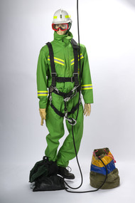 Department of Energy, Environment and Climate Action
Rappel model with protective equipment, harness and rope drop bag
Based on the earlier successful tests with the RAAF Dragonfly in 1948-49, together with the effective use of aircraft during the extensive Gippsland bushfires in March 1965, the Forests Commission took the plunge and contracted its own dedicated Bell 47G in the summer of 1965-66. This was an Australian first for any forest or bushfire agency. Rappelling trials at Snowy Plains and Tallangatta soon followed, which led to operations based at Heyfield with a two-man crew to quickly attack small fires in remote locations. The Heyfield rappel crew was another Australian first and remained in place for the following two fire seasons but lapsed after concerns from the Civil Aviation Safety Authority (CASA) about the stability of the small and underpowered Bell 47G. Later in 1982, after nearly 18 years absence, the Commission recommenced rappelling operations using larger and more powerful National Safety Council (NSCA) Bell 212 and Bell 412 helicopters based in Sale, Gippsland. During the 1983 bushfires, a specially trained and equipped FCV crew rappelled by rope from a hovering NSCA helicopter to suppress a small fire in remote terrain in the Orbost Forest District. Rappel model with protective equipment, harness and rope drop bagforests commission victoria (fcv), bushfire, bushfire aviation, safety equipment -
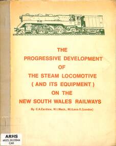 Victorian Railway History Library
Book, Cardew, C.A, The Progressive Development of the Steam Locomotive (and its Equipment) on the New South Wales Railways, 1965
A report on the progressive development of the steam locomotive and its equipment on the New South Wales Railways.ill, p.38.non-fictionA report on the progressive development of the steam locomotive and its equipment on the New South Wales Railways.railroad operations - new south wales - history, locomotives - new south wales - history -
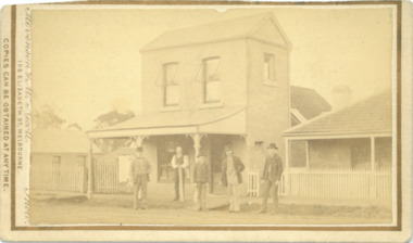 Bacchus Marsh & District Historical Society
Photograph, Express Office Church Street Bacchus Marsh 1883
The Express newspaper was founded in Bacchus Marsh in 1866. From 1870 it was produced in this two-storey building in Church Street Bacchus Marsh. The first issue was published on Saturday 7th July 1866. The first issues of the Express were produced in the house of its proprietor George Lane. This house can be seen at the rear of the two-storey building in this image. Around 1889 the size of the building was doubled. The Express was initially started and operated by a syndicate of local businessmen. After only a few months the syndicate ceased and George Lane a printer and his future son-in-law Christopher Crisp took over the ownership and operation of the Express. The Crisp family were associated with the Express for over 100 years. It was both a newspaper and printing business. The Express building was in use as a newspaper and printing business until the early 1980s. Since the 1980s the building has been used for a variety of retail and commercial purposes. The original printing equipment used by the Express is still present in the building and the site has been listed as a site of state heritage significance on the Victorian Heritage Register.Small sepia unframed photograph on card with gold border framing photograph. Housed in the album, 'Photographs of Bacchus Marsh and District in 1883 by Stevenson and McNicoll'. The image depicts the Bacchus Marsh Express building in 1883. It shows a two-storey building with a pitched roof and front verandah. Five men stand in front of the building facing the camera. On the first left is George Lane one of the proprietors. Second from the left is Christopher Crisp, the co-proprietor and editor of the Express. The other three men are unidentified but are possibly employees of the Express. The house on the right belonged to George Lane. The house to the left of the building belonged to Christopher Crisp. All three buildings remain in Bacchus Marsh in 2024.On the front: Stevenson & McNicoll. Photo. 108 Elizabeth St. Melbourne. COPIES CAN BE OBTAINED AT ANY TIME. On the back: LIGHT & TRUTH inscribed on a banner surmounted by a representation of the rising sun. Copies of this Portrait can be had at any time by sending the Name and Post Office Money Order or Stamps for the amount of order to STEVENSON & McNICOLL LATE BENSON & STEVENSON, Photographers. 108 Elizabeth Street, MELBOURNE. newspapers, bacchus marsh express, christopher crisp 1844-1915, printers, george lane 1823-1899 -
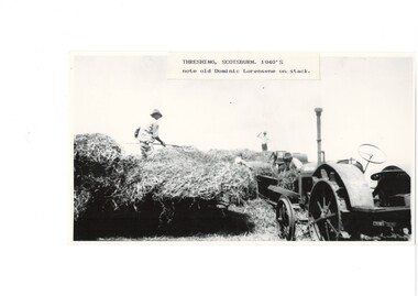 Buninyong & District Historical Society
Photograph - Copy of B/W photograph, Threshing machine at Scotsburn in 1940's, Not known
Photograph shows early farming method and illustrates some of the machines used at this timeThreshing machine in operation at Scotsburn in the 1940's. 3 workers and tractor visbleThreshing machine. 1940's. Note old Dominic Lorensene on stack.scene showing farm machinery in use. threshing machine vdriven by belt from stationary tractor., several man are working on the equipment, l -
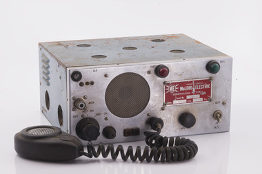 Forests Commission Retired Personnel Association (FCRPA)
Radio set
After the 1939 bushfires, the Forests Commission invested heavily in a radically new communications network. After suffering some inevitable delays due to the War, radio VL3AA switched into full operation in October 1945 proudly beaming out 200 watts across the State. The communication systems were regarded at the time to be more technically advanced than the police and the military. These pioneering efforts were directed by Geoff Weste, and later technical experts like Rex Philpot, John Whitehead, Charlie Reisinger and many others who designed, built and repaired most of the radio equipment. There was a dedicated radio laboratory at Surrey Hills in Melbourne.Radio setManufactured by McLeod Electric - Derrinallumradios, forests commission victoria (fcv) -
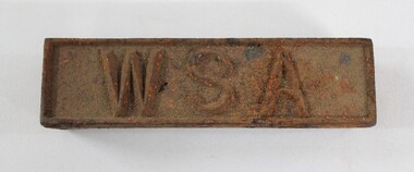 Wodonga & District Historical Society Inc
Functional object - Wodonga Sewerage Authority Identification Tag
The Wodonga Sewerage Authority identification tag is part of the collection of objects donated to the Wodonga Historical Society by the North East Region Water Authority in 2001. In 1983 the Wodonga Waterworks Trust and the Wodonga Sewerage Authority became part of the Wodonga Council. By 1989 a filtration plant at Huon Hill was completed, which provided filtered water of improved quality to Wodonga, in accordance with the World Health Organisation’s guidelines. In 1994 the Kiewa Murray Region Water Authority took over the Wodonga Council’s water and wastewater operations, and then in 1999 the Kiewa Murray Region Water Authority combined with the Ovens Region Water Authority and became the North East Region Water Authority or NERWA. NERWA then became known as North East Water. The identification tag has local significance due to its use by the Wodonga Sewerage Authority, as well as historic significance as rare example of the equipment used in water management in Wodonga.Rectangular corroded cast iron identification tag with the raised letters '"WSA" on the upper surface."W S A" on upper surface in raised letters.north east region water authority, nerwa, wodonga sewerage authority, north east water, n.e. water, kiewa murray region water authority, wodonga -
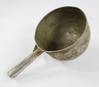 Wodonga & District Historical Society Inc
Functional object - Sand Scoop, North East Region Water Authority, Wodonga
The large aluminium sand scoop was used by Wodonga Waterworks Trust and it is part of the North East Region Water Authority collection in the Wodonga Historical Society. Wodonga's drinking water and wastewater were originally managed by the Wodonga Waterworks Trust, which was established in 1897, after Wodonga became a separate shire in 1876. In 1923 a Wodonga Waterworks Trust referendum to provide funding for new infrastructure to supply more water of better quality to Wodonga was passed. This included building the Wodonga Water Tower and it was completed in 1924. It supplied water to Wodonga until 1959, when it was drained and decommissioned after the No 1 Basin on Huon Hill was completed in 1958. In 1983 the Wodonga Waterworks Trust and the Wodonga Sewerage Authority became part of the Wodonga Council, and by 1989 a filtration plant at Huon Hill was completed, which provided filtered water of improved quality to Wodonga, in accordance with the World Health Organisation’s guidelines. In 1994 the Kiewa Murray Region Water Authority took over the Wodonga Council’s water and wastewater operations, and then in 1999 the Kiewa Murray Region Water Authority combined with the Ovens Region Water Authority and became the North East Region Water Authority or NERWA. NERWA then became known as North East Water. The sand scoop has local significance as part of the North East Region Water Authority collection donated to the Wodonga Historical Society. It also has wider state significance as a rare example of the equipment used in water management in Wodonga.Large aluminium scoop with a handle soldered on one side edge. Two holes and one indent in the end of the handle.north east region water authority, nerwa, wodonga waterworks trust, north east water, n.e. water, kiewa murray region water authority, sand scoop, metal scoop -
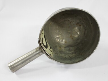 Wodonga & District Historical Society Inc
Functional object - Sand Scoop, North East Region Water Authority, Wodonga
The large aluminium sand scoop was used by Wodonga Waterworks Trust and it is part of the North East Region Water Authority collection in the Wodonga Historical Society. Wodonga's drinking water and wastewater operations were originally managed by the Wodonga Waterworks Trust, which was established in 1897, after Wodonga became a separate shire in 1876. In 1923 a Wodonga Waterworks Trust referendum to provide funding for new infrastructure to supply more water of better quality to Wodonga was passed. This included building the Wodonga Water Tower and it was completed in 1924. It supplied water to Wodonga until 1959, when it was drained and decommissioned after the No 1 Basin on Huon Hill was completed in 1958. In 1983 the Wodonga Waterworks Trust and the Wodonga Sewerage Authority became part of the Wodonga Council. And by 1989 a filtration plant at Huon Hill was completed, which provided filtered water of improved quality to Wodonga, in accordance with the World Health Organisation’s guidelines. In 1994 the Kiewa Murray Region Water Authority took over the Wodonga Council’s water and wastewater operations, and then in 1999 the Kiewa Murray Region Water Authority combined with the Ovens Region Water Authority and became the North East Region Water Authority or NERWA. NERWA then became known as North East Water. The sand scoop has local significance as part of the North East Region Water Authority collection donated to the Wodonga Historical Society. It also has wider state significance as a rare example of the equipment used in water management in Wodonga.Large aluminium scoop with a handle soldered on one side edge and a repair riveted to the interior surface of the scoop where the handle is located. The repair is a piece of sheet metal, with what looks like the lower part of the letter 'S' on it.Lower part of the letter "S" on the repair riveted to the interior surface of the scoop.north east region water authority, nerwa, wodonga waterworks trust, north east water, n.e. water, kiewa murray region water authority, metal scoop, sand scoop -
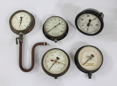 Wodonga & District Historical Society Inc
Functional object - Water Pump Pressure Gauges, North East Region Water Authority, Wodonga
The water pump pressure gauges were used by the Wodonga Waterworks Trust and Sewerage Authority, which were established in 1897, and had the responsibility for providing Wodonga's drinking water and managing the wastewater. In 1923 a Wodonga Waterworks Trust referendum to provide funding for new infrastructure to supply more water of better quality to Wodonga was passed. This included building the Wodonga Water Tower and it was completed in 1924. It supplied water to Wodonga until 1959, when it was drained and decommissioned after the No 1 Basin on Huon Hill was completed in 1958. In 1983 the Wodonga Waterworks Trust and the Wodonga Sewerage Authority became part of the Wodonga Council. By 1989 a filtration plant at Huon Hill was completed, which provided filtered water of improved quality to Wodonga, in accordance with the World Health Organisation’s guidelines. In 1994 the Kiewa Murray Region Water Authority took over the Wodonga Council’s water and wastewater operations, and then in 1999 the Kiewa Murray Region Water Authority combined with the Ovens Region Water Authority and became the North East Region Water Authority or NERWA. NERWA then became known as North East Water.The water pump pressure gauges have local significance due to their use by the Wodonga Waterworks Trust and Sewerage Authority, and donation from the North East Region Water Authority. They also have wider historical significance as examples of the equipment used in the management of water in Victoria and Australia.Five metal and glass water pump pressure gauges, including one with a U-shaped pipe and lever attached. "-HOMPSONS (CASTLEMAINE) LT-" on pressure gauge no.1 "BOURDON'S / PRESSURE GAUGE / THE AUSTRAL OTIS /ENGINEERING Co. LD. / MELBOURNE" on pressure gauge no.2 "No. 1609 / POUNDS PRESSURE / PER SQ. INCH / FEET HEAD OF WATER" on pressure gauge no. 3 "FEET HEAD OF WATER / THOMPSONS (CASTLEMAI-- LTD" on pressure gauge no. 4 "SET SLOW 33' -" / BUDENBERG / MADE IN AUSTRALIA / ft water / 1 4 9 3 9 each number underlined" on pressure gauge no. 5north east region water authority, nerwa, wodonga sewerage authority, north east water, n.e. water, wodonga waterworks trust, pressure gauges, water pump pressure gauges -
 Warrnambool and District Historical Society Inc.
Administrative record - Ledgers (2) - Bruce & McClure, Bruce & McClure business administrators, Petty Cash Book; Share Register, 1916-1945
These two ledgers come from the Warrnambool business of Bruce and McClure. One ledger is a Petty Cash Book with entries dating from 1941 to1945 and the other is a Share Register with entries from 1916 to 1933. The business of Bruce and McClure was located at 159-165 Lava Street Warrnambool and was established about 1900 in premises originally occupied by the plumber and fitter, W. Flett and the blacksmith and farrier, W. Hopkins and in the 1890s by the engineering works of Dobson and Parkinson. Bruce and McClure were engineers, ironfounders and windmill makers and manufactured, produced and serviced farm equipment in a wide area around Warrnambool. In 1945 the business was purchased by the Owen Brothers who later relocated to Caramut Road Warrnambool where it still operates today. These ledgers are of historic interest as they contain details of the operations of an important 20th century business in Warrnambool (Bruce & McClure) and they are very useful for local research. .1 Ledger with a hard green cover and dark red binding. The pages contain red and blue lines and handwritten entries in ink. Some pages are loose and there are some inserts with typed sheets. .2 Ledger with a green cover and dark red binding on the spine. There are alphabetical tabs in the front of the book and the pages contain printed red and blue lines and printed headings. The entries are handwritten in ink. Most of the pages are empty.bruce & mcclure warrnambool, windmill makers warrnambool, owens of warrnambool -
 Moorabbin Air Museum
Document (Item) - (SP) Technical Orders - multitude - list in "Context"
Possibly related to navigationtechnical order an 03-10abb-163 cyl plug selector valve assy overhaul with parts breakdown, technical order an 03-5-308 switch pressure actuated overhaul with parts breakdown, technical order an 05-55a-13 d-c selsyn position indicators and transmitters, technical order an-03-10abb-237 swing check valve overhaul with parts breakdown, technical order to-00-20a-2 airplane maintenance forms, technical order to-01-1-390 food and galley equipment responsibility, technical order to-01-1-515 rework solenoid control head part 966129, technical order to-01-1-619 oxygen regulators inspection and replacement, technical order to-02-10ab-1 r985 aircraft engines operations, technical order to-03-1-6 solenoid meshing devices ops service overhaul, technical order to-06-1-8 fuels and lubricants, technical order to-06-10-1 lubrication oils grades and use, technical order to-08-5-10 radio scr-578-a defective reels rl-48, technical order to-1-1-383 removal of ammunition from aircraft, technical order to-10-25-3 film developer assy operations servicing parts catalog, technical order to-14s3-1-503 inspection of life raft co2 cylinders, technical order to-15a1-2-12-3 air pressure regulator overhaul, technical order to-15h4-2-2-3 ignition units overhaul, technical order to-15h6-2-2-123 cockpit temperature control box, technical order to-15h6-2-2-13 cockpit temperature control box, technical order to-15h6-2-2-163 cockpit temperature control box overhaul, technical order to-1f-1-525 safety wirting pilot oxygen shutoff valve, technical order to-1f-86-210 sabre electrical connector for test equipment, technical order to-2r-0470-12 an 02a-40eb-2 aircraft engines service, technical order to-2r-0470-13 an 02a-40eb-3 aircraft engines overhaul, technical order to-2r-0470-14 an 02a-40eb-4 aircraft engines parts breakdown, technical order to-4s-1-2 high pressure air valve cores, technical order to-4s5-2-3 tail skid shock struts overhaul, technical order to-5f4-3-3 true airspeed signal control amplifier overhaul, technical order to-6j13-2-1-501 dual float switch assy installation, technical order to-6j14-1-5 torque values self sealing bladder cell multi bolt fittings, technical order to-6j3-4-15-4a vs-2 fuel regulator parts breakdown, technical order to-6j5-15-3 fuel filetr assy overhaul, technical order to-6j5-15-4 fuel filter assy parts breakdown, technical order to-6j5-18-3 micronic filters overhaul, technical order to-6j5-18-4 micronic filters parts breakdown, technical order to-6j5-24-3 av fuel filter replaceable micronic element, technical order to-6j5-5-3 fuel filter 03s12166d overhaul with parts breakdown, technical order to-6r-1-2 engine carburetor installation, technical order to-6r1-3-1-35 bendix injector carburetor overhaul, technical order to-6r9-2-11-3 valve check overhaul with parts breakdown, technical order to-6r9-2-12-3 swing check valve overhaul with parts breakdown, technical order to-6r9-2-14-3 check valve flow indicator overhaul wth parts breakdown, technical order to-8a6-3-3-3 ac generator overhaul, technical order to-8a6-8-4-4 engine driven aircraft generator parts breakdown, technical order to-8a6-9-3-3 aircraft ac generator overhaul, technical order to-8d1-21-3-33 fractional horsepower motor 5ba25aj28b overhaul with parts breakdown, technical order to-8d1-21-3-33 fractional horsepower motor 5ba25mj426b overhaul with parts breakdown, technical order to-8d1-29-2-3 direct current motor parts breakdown, technical order to-8d1-9-13-23 oil cooler flap control overhaul parts breakdown, technical order to-8d1-9-19-3 direct current motor overhaul with parts breakdown, technical order to-8d1-9-21-3 electromechanical linear actuator overhaul, technical order to-8d1-9-21-4 electromechanical linear actuator parts breakdown, technical order to-8d1-9-22-3 electromechanical power unit overhaul, technical order to-8d1-9-22-4 electromechanical power unit parts breakdown, technical order to-8d3-8-6-3 position light flasher overhaul, technical order to-8d6-5-4-504 mod westinghouse generator a45j247, technical order to-8e2-5-2-13 aircraft magnetos overhaul, technical order to-8e2-5-2-14 aircraft magnetos parts breakdown, technical order to-8ri-3-5-3 generator field control relay m-2 overhaul, technical order to-9h4-2-24-4a stratopower hydraulic pump parts breakdown -
Moorabbin Air Museum
Document (Item) - Handbook Operation And Maintenance Instructions TS-1548/UP Test Equipment Spectrum Analyser
AN 16-35TS148-5 -
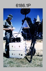
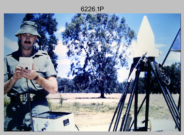 Bendigo Military Museum
Photograph - Demonstration of TI4100 GPS Receiver, Royal Australian Survey Corps, c1988
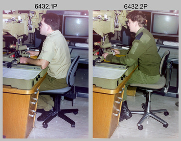
This is a set of four photographs of WO2 Graham Ragless from the Royal Australian Survey Corps demonstrating the operation of Global Positioning System equipment in c1988. The photos were probably taken at the School of Military Survey (SMS), Bonegilla, VIC. Texas Instruments TI4100 portable Global Positioning System (GPS) geodetic receivers were introduced from 1986–1988. The GPS receivers and Ferranti FILS3 helicopter and vehicle mounted Inertial Positioning System (IPS) replaced the TRANSIT satellite receivers. The equipment was deployed to establish the baseline for a GPS controlled air camera and photogrammetric system to significantly reduce the requirement for ground survey to accurately control air photography for topographic mapping. Personnel from the four field survey squadrons at this time were trained at the SMS to operate the TI4100 receivers. Field survey operations using GPS and IPS equipment followed in the late 1980s. This technology is described in more detail in the RA Svy booklet titled An Introduction to Topographic Mapping. See record ID - 6010. WO2 Graham Ragless progressed to the rank of WO1 and was appointed as RSM of the Army Survey Regiment from 1990 to 1992. Refer to item 6186.2P for more photographs of WO2 Graham Ragless demonstrating the TI4100.This is a set of four photographs of a technician from the Royal Australian Survey Corps demonstrating the operation of Global Positioning System equipment in c1988. Colour photos are on 35mm slide film and were scanned at 96 dpi. .1) to .4) - Photo, colour, c1988, WO2 Graham Ragless demonstrating the operation of a TI4100 GPS receiverThere are no annotations.royal australian survey corps, rasvy, army survey regiment, army svy regt, fortuna, asr, surveying -
 Bendigo Military Museum
Photograph - Demonstration of TI4100 GPS Receiver, Royal Australian Survey Corps, c1988
This is a set of two photographs of WO2 Graham Ragless from the Royal Australian Survey Corps demonstrating the operation of Global Positioning System equipment in c1988. The photos were probably taken at the School of Military Survey (SMS), Bonegilla, VIC. Texas Instruments TI4100 portable Global Positioning System (GPS) geodetic receivers were introduced from 1986–1988. The GPS receivers and Ferranti FILS3 helicopter and vehicle mounted Inertial Positioning System (IPS) replaced the TRANSIT satellite receivers. The equipment was deployed to establish the baseline for a GPS controlled air camera and photogrammetric system to significantly reduce the requirement for ground survey to accurately control air photography for topographic mapping. Personnel from the four field survey squadrons at this time were trained at the SMS to operate the TI4100 receivers. Field survey operations using GPS and IPS equipment followed in the late 1980s. This technology is described in more detail in the RA Svy booklet titled An Introduction to Topographic Mapping. See record ID - 6010. WO2 Graham Ragless progressed to the rank of WO1 and was appointed as RSM of the Army Survey Regiment from 1990 to 1992. Refer to item 6226.4P for more photographs of WO2 Graham Ragless demonstrating the TI4100.This is a set of two photographs of a technician from the Royal Australian Survey Corps demonstrating the operation of Global Positioning System equipment in c1988. Colour photos are on 35mm slide film and were scanned at 96 dpi. .1) and .2) - Photo, colour, c1988, WO2 Graham Ragless demonstrating the operation of a TI4100 GPS receiverThere are no annotations.royal australian survey corps, rasvy, army survey regiment, army svy regt, fortuna, asr, surveying -
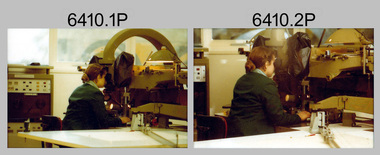 Bendigo Military Museum
Photograph - Capturing Topographic Features with a Wild B8, AUTOMAP 1 Systems Operations – Army Survey Regiment, Fortuna, Bendigo, 1980
This is a set of 24 photographs of Air Survey Squadron technicians capturing topographic Features with a Wild B8 stereo plotter and operating AUTOMAP 1 equipment at the Army Survey Regiment at Fortuna, Bendigo, 1980. 17 of these photographs were taken of SPR Nick Van Dalen and SPR Santina (Argetto) Straube capturing topographic features – plotting with a Wild B8 stereo plotter were most likely taken in 1980. See item 6185.4P for black & white copies of photos of SPR Santina (Argetto) Straube operating the Wild B8 stereo plotter. Refer to item 6204.8P for detailed information and additional photographs of the Wild B8 stereo plotter. The history of the AUTOMAP 1 system is covered in more detail with additional historic photographs in pages 116-118 of Valerie Lovejoy’s book 'Mapmakers of Fortuna – A history of the Army Survey Regiment’ ISBN: 0-646-42120-4. See items 6122.20P, 6183.19P, 6184.20P, 6200.5P, and 6222.17P for additional photographs of the AUTOMAP 1 system.This is a set of 24 photographs of Air Survey Squadron technicians capturing topographic features with a Wild B8 stereo plotter and operating AUTOMAP 1 equipment at the Army Survey Regiment at Fortuna, Bendigo, c1980. The photographic proofs were printed on photographic paper and are part of the Army Survey Regiment’s Collection. The photographic proof prints were scanned at 600 dpi. .1) to .8) Photo, black & white, 1980. SPR Santina (Argetto) Straube operating a Wild B8 stereo plotter. .9) to .17) Photo, black & white, 1980. SPR Nick Van Dalen operating a Wild B8 stereo plotter. .18) to .24) Photo, black & white, 1980. CPL Gerry Gunn undertaking AUTOMAP 1 computer system duties..1P to .24P – no annotations.automap 1, royal australian survey corps, rasvy, army survey regiment, army svy regt, fortuna, asr, photogrammetry -
 Bendigo Military Museum
Photograph - Capturing Topographic Features with a Wild B8, AUTOMAP 2 Systems Operations – Army Survey Regiment, Fortuna, Bendigo, 1990
This is a set of two photographs of Air Survey Squadron technicians - LCPL Peter Murphy and SPR Rachel (Stanford) Scott capturing topographic features with a Wild B8 stereo plotter with AUTOMAP 2 equipment at the Army Survey Regiment, Fortuna, Bendigo, c1990. Refer to item 6185.4P and 6204.8P for detailed information and additional photographs of the Wild B8 stereo plotter. The history of the AUTOMAP 2 system is covered in more detail with additional historic photographs in pages 119, 137-142 and 180 of Valerie Lovejoy’s book 'Mapmakers of Fortuna – A history of the Army Survey Regiment’ ISBN 0-646-4: 2120-4. See items 6087.10P and 6223.23P for additional photographs of the AUTOMAP 2 system.This is a set of two photographs of Air Survey Squadron technicians capturing topographic features with a Wild B8 stereo plotter with AUTOMAP 2 equipment at the Army Survey Regiment at Fortuna, Bendigo, c1990. The photographs are on 35mm negative film. They are part of the Army Survey Regiment’s Collection. The photographic negatives were scanned at 96 dpi. .1) - Photo, colour, 1990. LCPL Peter Murphy operating a Wild B8 stereo plotter. .2) - Photo, colour, 1990. SPR Rachel (Stanford) Scott operating a Wild B8 stereo plotter..1P to .2P – no annotationsroyal australian survey corps, rasvy, army survey regiment, army svy regt, fortuna, asr, photogrammetry -
 Bendigo Military Museum
Photograph - RA Svy Project C4 Aerodist Operation, Eastern Arnhem Land, NT, 1967
This is a set of 30 photographs of Royal Australian Survey Corps (RA Svy) personnel from Central Comd Fd Svy Unit (Adelaide) on Aerodist survey operation - Project C4 in Eastern Arnhem Land, Northern Territory in 1967. Photos of personnel were taken either at the operations base at Numbulwar or the main base at Gove (Nhulunbuy). RA Svy conducted nineteen Aerodist operations for 12 years from 1964 to 1975. Aerodist MRC2 was a tellurometer-based system adapted for aircraft to accurately measure distances between non-intervisible ground survey stations, using the aircraft as an intermediate station. Lower order geodetic results could be achieved by survey network trilateration. The measured distances between stations formed survey networks from which each station’s latitude and longitude was computed. Aerodist MRC2 was RA Svy’s major horizontal control survey tool for mainly medium scale topographic mapping (scale 1:100,000 Class A being spatially accurate to within 50 metres) in PNG, northern NT, north-west WA, Kalimantan Barat (West) Indonesia, Sumatra Indonesia, Gulf of Carpentaria and Cape York, QLD. In 1967, the Aerodist MRC2 Master equipment was installed in the aircraft featured in this set of photos, Executive Air Services’ (Essendon VIC) Grand Aero Commander VH-EXX. It was the same aircraft type and company contracted to Division of National Mapping for Aerodist MRC2 surveys. From July to October 1967 the aircraft was attached to Central Comd Fd Svy Unit (Adelaide - Major Don Ridge) on Project C4 eastern-Arnhem Land NT, where 317 Aerodist lines measuring 17,300 line miles were successfully completed. This was the most productive Aerodist project thus far. The most common helicopter used by RA Svy up to 1972 was the civilian Bell 47G-2 and the Sioux Light Observation Helicopters (LOH), the Australian Army’s equivalent featured in this photo set. These light observation helicopters had a limiting load carrying capacity of up to about 500 pounds. By comparison, one Aerodist team including two people weighed up to 1,500 pounds. Source: Royal Australian Survey Corps – Aerodist Years 1964-1975 by Peter Jensen. This is a set of 30 photographs of Royal Australian Survey Corps (RA Svy) personnel on Aerodist survey operations in Eastern Arnhem Land, Northern Territory in 1967. The photographs are on 35mm negative film and scanned at 96 dpi. They are part of the Army Survey Regiment’s Collection. .1) to .4) - black & white, 20th August 1967, Project C4 Aerodist Operations Base - Numbulwar, NT. .5) - Photo, black & white, 1967. Probable wrecked Indonesian fishing vessel. .6) to .8) - Photo, black & white, 1967. Unidentified survey operations base, L to R: unidentified personnel. .9) - Photo, black & white, 1967. Unidentified survey operations base, unidentified soldier driving a Haflinger 4x4 Light utility vehicle. .10) - Photo, black & white, 1967. Unidentified survey operations base, L to R: unidentified technician. .11) - Unidentified technician reading two survey altimeters to compute corrections to the measured distances for atmospheric refraction and to compute the sea level distances from the slope distances aircraft to the ground stations. .12) - Photo, black & white, 1967. Unidentified survey operations base, L to R: unidentified personnel. .13) to .16) - Photo, black & white, 1967. Unidentified personnel operating remote Aerodist MRC2 ground instruments. .17) to .18) - Photo, black & white, 1967. Unknown RA Svy office location. .19) to .20) - Photo, black & white, 1967. Aerodist MRC2 Master equipment. .21) to .22) - Photo, black & white, 1967. Aero Commander VH-EXX probably at Gove, NT, Central Comd Fd Svy Unit (Adelaide) – OC Major Don Ridge. .23) to .25) - Photo, black & white, 1967. Aero Commander VH-EXX probably at Gove, NT. Unidentified personnel. .26) - Photo, black & white, 1967. Aero Commander VH-EXX probably at Gove, NT. Aerodist antenna pods are visible on the aircraft. .27) to .29) - Photo, black & white, 1967. Australian Army Sioux Light Observation Helicopter (LOH) probably at Gove, NT. .30) - Photo, black & white, 1967. Panelled U337 survey station, visible as a white cross on aerial identification photo..1P to .2P – date and location on edge of film negative. .5P to .28P – no annotations .29P - annotated in white ‘RW-JEP Gove NT’ .30P - annotated in white ‘U337 Spool No1 Jun67’royal australian survey corps, rasvy, army survey regiment, army svy regt, fortuna, asr, aerodist, surveying, central comd fd svy unit -
 Falls Creek Historical Society
Document - Meeting Minutes Of Falls Creek Alpine Village Advisory Committee
Bob Hymans Collection Bob (Herman) Hymans (a former member of the Royal Netherlands Navy was born in Bloemendaal, Holland on 30th September 1922. During World War II he fought against the Japanese in the Dutch East Indies (now Indonesia) and was imprisoned in Changi and on the Burma Railway. After gaining qualifications as a Ski Instructor, Bob arrived in Falls Creek in May 1950. Working as an Instructor and Supervisor at Bogong Lodge, Bob decided his future was in accommodation. He was successful in negotiating an indenture for land from the State Electricity Commission (SEC). It took Bob two years to build his Grande Coeur Chalet but, tragically, it was burned down in August 1961. Bob also built the first Chairlift in Australia. This was a single chairlift and the structure was built from wooden electricity poles. He was constantly full of new ideas and proposals for the village. Bob Hymans died on 7th July 2007. This Collection of documents and letters tells the story of Bob’s endeavours to develop Falls Creek into the ski village it is today.This document is significant because it documents discussion concerning the operation of Falls Creek.MInutes of the Falls Creek Alpine Village Advisory Committee held on 21 September 1957 typed on foolscap size paper. Topics of discussion included contributions to the Ski Improvement Fund, equipment in the Casualty Room and also the possibility of erecting a simple rope tow on the nursery slope.chairlift falls creek, bob hymans, ski improvement fund, falls creek alpine village advisory committee