Showing 2304 items matching "parishes"
-
 Bendigo Historical Society Inc.
Map - DERBY, No date visible
Map: Derby. Hand draughted parish plan (number 303 in map cupboard 1)map, bendigo, parish plan, derby -
Bendigo Historical Society Inc.
Map - EPPALOCK, COUNTY OF BENDIGO MAP, 3/11/1882
Map: Eppalock, County of Bendigo. Parish plan (number 302 in map cupboard 1)map, bendigo, parish plan, eppalock -
Bendigo Historical Society Inc.
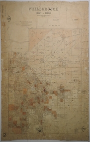
Map - NEILBOROUGH, 15/10/1877
Map: Neilborough, County of Bendigo. Parish plan (number 301 in map cupboard 1)map, bendigo, parish plan, neilborough, elysian flat -
Bendigo Historical Society Inc.
Map - LEICHARDT, Circa 1870's
Map: Leichardt, Hand draughted parish plan ( number 300 in map cupboard 1 )map, bendigo, parish plan, leichardt -
Bendigo Historical Society Inc.
Map - HAYANMI, 16/05/1879
Map: Hayanmi, County of Bendigo. Parish plan (number 294 in map cupboard 1)map, bendigo, parish plan, hayanmi -
Bendigo Historical Society Inc.
Map - REDCASTLE, 15/10/1878
Map: Redcastle, County of Rodney. Parish plan. (number 293 in map cupboard 1)map, rodney, parish plan, redcastle -
Bendigo Historical Society Inc.
Map - WESTON RESURVEY, June 20th 1875
Map: Weston, Resurvey.Hand draughted Parish plan (number 292 in map cupboard 1)map, parish plan, weston -
Bendigo Historical Society Inc.
Map - STRATHFIELDSAYE, 25/06/1877
Map: Strathfieldsaye, County of Bendigo. Parish plan (number 291 in map cupboard 1)map, bendigo, parish plan, strathfieldsaye -
Bendigo Historical Society Inc.
Map - RUNNYMEDE, 2/05/1895
Map: Runnymede, County of Rodney. Parish plan (number 285 in map cupboard 1)map, rodney, parish plan, runnymede, county of rodney -
Bendigo Historical Society Inc.
Map - NOLAN, 5/03/1888
Map: Nolan, County of Bendigo. Parish plan (number 284 in map cupboard 1)map, bendigo, parish plan, nolan -
Bendigo Historical Society Inc.
Map - MINTO, /01/1884
Map: Minto, County of Bendigo. Parish plan (number 283 in map cupboard 1)map, bendigo, parish plan, minto -
Bendigo Historical Society Inc.
Map - PANNOOMILLOO, 21/06/1882
Map: Pannoomilloo, County of Bendigo. Parish plan (number 282 in map cupboard 1)map, bendigo, parish plan, pannoomilloo -
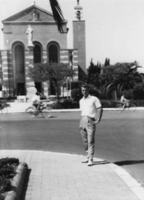 Slovenian Association Melbourne
Photo, Town Latina Parish church, L Markic, Summer 1960
Slovenian refugee on an outing to explore Latina, ItalySlovenian refugee passing time by exploringBlack and white photo of Lojze (Alojz) Markic in Latina Italy in front of the parish churchslovenian refugee, slovenian association melbourne -
Whitehorse Historical Society Inc.
Map, Plan, 1939
Plan of subdivision, part of crown portion 83A and 83, Parish of Nunawading, County of BourkePlan of subdivision, part of crown portion 83A and 83, Parish of Nunawading, County of BourkePlan of subdivision, part of crown portion 83A and 83, Parish of Nunawading, County of Bourkestreet names, parish of nunawading, station street, blackburn, railway road, blackburn, vine street, blackburn, south parade, blackburn, laburnum street, blackburn, main street, blackburn, gardenia street, blackburn, the avenue, blackburn, fuschia street, blackburn, linum street, blackburn -
Lakes Entrance Historical Society
Book, Tolleg C W, The Anglican Parish of Bairnsdale 120th Anniversary, 1987
A brief chronological history of the Anglican Parish of St John the Baptist Bairnsdale Victoria Ilustrated.religion -
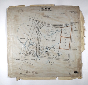 Bendigo Historical Society Inc.
Map - MARONG ALLOTMENTS, 25/08/1906
Map: Plan of Allotments at Marong, Parish of Marong, County of Bendigo. Hand draughted mapmap, bendigo, parish plan, marong, parish of marong -
 Bendigo Historical Society Inc.
Map - Marong County of Bendigo
Map of Marong. Drawn and reproduced at the Dept. of Lands and Survey, Melbourne. By authority: W.M. Houston Government Printer. June 1953.On the back in blue pen: certified plan parish Marong, signed minister and seal affixed for land S sec.72 evidence act. I certify that this a true plan parish Marong (signature illegible) minister for lands.map, marong -
Bendigo Historical Society Inc.
Map - CAMPBELL COLLECTION: BENDIGO & DISTRICT MAPS, 22-3 29
Map. Marong, Parishes of Marong, Lockwood and Mandurang. Scale 20 chains to an inch. Total area 5106 acres. Crusoe Reservoir on right. Compiled in W.P.B. from Field Survey and Parish Plans (number 373 in map cupboard 1)G.W.Lmap, bendigo, allotments -
Bendigo Historical Society Inc.
Map - CAMPBELL COLLECTION: BENDIGO AND DISTRICT MAPS
Map. Marong, Parishes of Marong, Lockwood and Mandurang. Scale 20 chains to an inch. Total 5106 acres. Compiled in W.P.B. from Field Survey and Parish Plans. Crusoe Reservoir to the right of map. (number 362 in map cupboard 1)map, bendigo, parish plan -
Bendigo Historical Society Inc.
Map - TOWNSHIP OF LOCKINGTON, 21/09/1915
Map: Township of Lockington, Parish of Bamawm, County of Bendigo. Parish plan.Has a clipping from 'The Riverine Herald' dated 20/11/1915 on the reverse side re. the sale of blocks in Bamawm Township (number 322 in map cupboard 1)map, bendigo, township, lockington, bamawm, the riverine herald -
Bendigo Historical Society Inc.
Map - CAMPBELL COLLECTION: BENDIGO AND DISTRICT MAPS, 14-6-29
Map. Terricks, Parish of Terrick Terrick West, scale 20 chains to 1 inch, total area 6318 acres, prepared in W.P.B. from Assessment and Parish Plans by W.J.G. 14-6-29. (number 388 in map cupboard 1)W.J.Galbraithmap, bendigo, agricultural lands -
Whitehorse Historical Society Inc.
Article, Retirement living, 1994
St Thomas Community Retirement Village situated in Hawthorn Road, Forest Hill is now completed. The village is under the auspices of the Parish of St Thomas the Apostle. Parish consultant Ken Marmion says the village was a concept of non-denominational Christian living.retirement homes and villages, st thomas community retirement village, st thomas the apostle catholic church, blackburn, marmion, kevin, southern cross homes inc. -
Lakes Entrance Historical Society
Book, St Brendans Parish Lakes Entrance Memories from 1930-1994, 1994
Reminiscences of St Brendans Roman Catholic Parish of lakes Entrance Victoria. memories of boyhood in 1930, befoe the St Brendans School was established are recalled and parish activities up to 1994, including the disastrous fire of 7 January 1978 when threligion, schools -
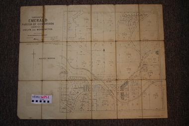 Emerald Museum & Nobelius Heritage Park
Two maps of Emerald Township 1955 and 1922, Emerald Township
The Photo Lithographed Maps belonged to George and Mary A'Vard. They are early maps of Emerald Township in 1955 and 1922.VEMU1659.1 Township of Emerald, Parish of Gembrook, Counties of Evelyn and Mornington; September 1955 VEMU1659.2 Township of Emerald, Parish of Gembrook, Counties of Evelyn and Mornington: Drafted 12 Sep 1892, Examined 30 Sep 1892, Additions 17 Jun 1922 -
 Bendigo Historical Society Inc.
Map - NEILBOROUGH, 6/12/1882
Map: Parish of Neilborough, County of Bendigo. Parish plan. J A Morrison Junior June 1877. Examined by ? Harvey 21/8/1877. Additions made by J V Walshe24/10/82. Examined by E D 39/10/82.map, bendigo, parish plan, neilborough, j a morrison jr., harvey, j v walshe -
 Ringwood and District Historical Society
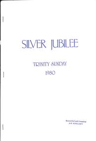
Book, Silver Jubilee - Trinity Sunday 1980, 1980
History of Holy Trinity Church, Patterson Street,. Ringwood East - 25th Anniversary 1955-1980, researched and compiled by A.H. ScollaryForeword by The Rev. Dr. George A. Mullins, first vicar of The Parish of Holy Trinity Ringwood East -
 Halls Gap & Grampians Historical Society
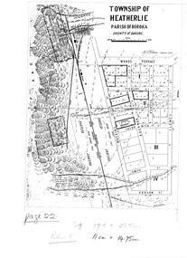
Map - Photocopy
Photocopy of map of Heatherlie TownshipTownship of Heatherlie; Parish of Boroka; County of Borung; scale measurement; R.O. Robson Authorised Surveyormaps, heatherlie township -
 Halls Gap & Grampians Historical Society
Map - Coloured
Map showing layout for township of HeatherlieTownship of Heatherlie; Parish of Boroka; County of Borung; scale measurement; R.O. Robson Authorised surveyormaps, heatherlie township -
 City of Moorabbin Historical Society (Operating the Box Cottage Museum)
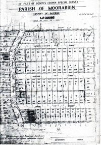
Flyer - Garfield Estate, Ormond
At the end of World War One, there was a renewed interest in residential land and a number of estates opened up in the Municipality of Moorabbin.Example of the progress of the Municipality of MoorabbinPhotocopy of the plan of the Garfield Estate, OrmondPart f Dendy's Crown Special Survey - parish of Moorabbin - County of Bourke - Garfield Estatedraper street, lord street, hudson street, blackshaw street, tucker road, ormond, mckinnon, real estate -
 Ringwood and District Historical Society
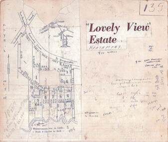
Map, Plan of Subdivision - Lovely View Estate, Heathmont, Victoria (Undated, circa 1930s)
Photocopied map from land sale brochure with handwritten real estate sales notations. Subdivision includes allotments on Dickason's Road and Allen's Road, Heathmont.LP3917 Part of Crown Allotments 14A-40A Parish of Ringwood. Vol 3232 Fol 626380.