Showing 1432 items
matching planning development
-
 Federation University Historical Collection
Book, Frank Hurley, An Event That Never Happened: The history and politics of decentralisation in Victorian and New South Wales 1885-1985 (Thesis), 1989
This thesis is an account of movements and policies for decentralisation of population and economic activity away from metropolitan to non-metropolitan areas in Victoria and New South Wales between 1885 and 1985. Red hard covered thesis undertaken for a Doctory of Philosphy ot the University of Melbourne. frank hurley, thesis, doctorate, decentralisation, ppoulation, economics, policy, closer settlement acts, urbanisation, decentralisation league, war and reconstruction, central planning, town planning, victorian decentralisatoin league, owen paper mill, slough estate, noel mobbs, ballarat common, edgar bartrop, australian paper mills, bendix mintex, ball, ballarat development committee -
Federation University Historical Collection
Booklet, Ballarat School of Mines Report to Council on Possible Future Building Developments, 1965, 1965
A foolscap plan with a number of plans relating to possible future building developments at the Ballarat School of Mines. Includes proposed plan for the former M.B. John Site (neaar brew tower)ballarat school of mines, buildings, building developments, e.j. barker, library, engineering and applied science, gaol residences, trades, ballarat junior technical school, materials testing laboratory, martin report, hickman street -
Federation University Historical Collection
Booklet - Report, Proposals for the Development of The Lydiard Street Site of the School of Mines and Industries, Ballarat, 1974, 20/11/1974
The report includes an organisational diagram, general aims, facilities, estimated floor areas.Twenty eight page typed report of proposals for the Development of the SMB campus, and a proposed title for the College "Ballarat Regional College". There is also a page on the advantages of student residential accommodation.smb campus, campus plans, ballarat regional college, ballarat school of mines lydiard street, gardens, library, student accomodation -
 Federation University Historical Collection
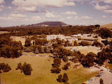
Photograph - Photograph - Colour, VIOSH: Early photograph of the Mount Helen Campus - Ballarat Institute/College of Advanced Education
Victorian Institute of Occupational Safety and Health (VIOSH) Australia is the Asia-Pacific centre for teaching and research in occupational health and safety (OHS) and is known as one of Australia's leaders on the field. VIOSH has a global reputation for its innovative approach within the field of OHS management. VIOSH had its first intake of students in 1979. At that time the Institution was known as the Ballarat College of Advanced Education. In 1990 it became known as Ballarat University College, then in 1994 as University of Ballarat. It was 2014 that it became Federation University. VIOSH Australia students are safety managers, senior advisors and experienced OHS professionals. They come from all over Australia and industry. Students are taught active research and enquiry; rather than textbook learning and a one-size fits all approach. VIOSH accepts people into the Graduate Diploma of Occupational Hazard Management who have no undergraduate degree - on the basis of extensive work experience and knowledge. In 1964 the Victorian Government announced that a committee be established to plan for the establishment of a Victorian Institute of Colleges. Eight Technical colleges would be raised to the level of university colleges. Ballarat School of Mines was on the list. Plans were also underway for the development of a new campus at Mount Helen. The Mount Helen Campus was officially opened on 30 October 1970 by the Hon Sir Nigel Bowen, Minister for Education and Science. It was at this Campus, in 1977, that VIOSH was conceived and from 1979, when the first intake of VIOSH students started, it became a significant course at Ballarat College of Advanced Education and continued to recent times.Colour photograph showing the Mount Helen Campus buildings.viosh, victorian institute of occupational safety and health, victorian institute of colleges, ballarat school of mines, university colleges, hon sir nigel bowen, minister for education and science, mount helen campus, ballarat college of advanced education -
Federation University Historical Collection
Photograph, Dr Ron Wild, 27/10/1994
Ballarat School of Mines Director, Dr Ron Wild (right) shows Tertiary Educaton Arts and Gamining Minister Haddon Storey plans for the 76 millions dollar development. Barry Traynor MP at extreme left. ballarat school of mines, ron wild, barry traynor, haddon storey -
 Federation University Historical Collection
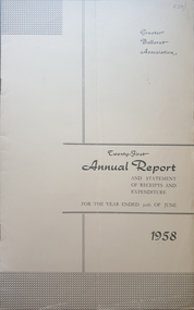
Booklet - Annual Report, Greater Ballarat Association Annual Report 1952-1974, 1952-1974
The first presedent of the Greater Ballarat Association in 1938 was Robert J. Cooke. Eighteen annual reports of the Greater Ballarat Association. Each one discussed the work of the association and lists the subscribers. greater ballarat association, annual report, edgar bartrop, g.b. richmond, a.w. nicholson, g.e. deeble, r.g> caddell, l.j. fraser, t.u. haymes, a.w. lynch, keith rash, tourist bureau, botanical gardens telepone booth, pryor park tree planting, ballarat zoological gardens, centenary window dressing competition, soldier settlement, proposal for university for ballarat, caravan park, ballarat common, ballarat common development, t.t. hollway, housing commission, wendouree housing commission, industrial development, s.s. ballarat, begomia festiva, r.g. caddell, w.gordon smith, f.h. menzies, olympic rowing, royal tour decorations, begonia float, widening of railway bridge, j. chatham, l.g. chester, s.v. playsted, n. ellis, langi kal kal, langi kal kal training centre, migrants to victoria, flood lighting of the arch of victory, olympics holidays, ballarat's projected olympic pool, ballarat fish hatcheries, olympic hostel, town planning, murray byrne, titles for residence areas, service club signs, railway level crossing, traffic, ploughing competition, w. fraser, young australia league, removal of raaf from ballarat, renumbering of streets, renumbering of streets to the block system, miners' racecourse reserve, historical museum, ballarat historical society, c.m. canty, mavis canty, university status, ballarat university college, j.w. murray, p.r. gray, b.c. mcorist, n.c. ellis, w.h. heinz, save the lake campaign, lake wendouree, weed, home host scheme, b. walker, develop victoria council, eureka development, victorian decentralization league, r.h. ramsay, allan c. pittard, w. gordon smith, c.h. davis, b.c. hedgcock, les kennedy, p.j. rice, a.f. waddington, john p. cook, historic markers, maze, traffic lights, bungal dam, camera clubs, sunraysia way, map, centre of road parking, paddle steamer, wendouree apex, local government women's association, may nelson, wes sobey, melton foo, l.l. zilles, dulcie sullivan, m. barnes, lou zilles, john wesley sobey, e.r. ingles, herb warren, kryal castle -
 Federation University Historical Collection
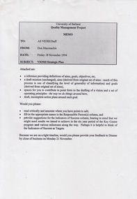
Document - Document - Project, VIOSH: University of Ballarat, Strategic Plan; Quality Management Project 1994
Victorian Institute of Occupational Safety and Health (VIOSH) Australia is the Asia-Pacific centre for teaching and research in occupational health and safety (OHS) and is known as one of Australia's leaders on the field. VIOSH has a global reputation for its innovative approach within the field of OHS management. VIOSH had its first intake of students in 1979. At that time the Institution was known as the Ballarat College of Advanced Education. In 1990 it became known as Ballarat University College, then in 1994 as University of Ballarat. It was 2014 that it became Federation University. VIOSH Australia students are safety managers, senior advisors and experienced OHS professionals. They come from all over Australia and industry. Students are taught active research and enquiry; rather than textbook learning and a one-size fits all approach. VIOSH accepts people into the Graduate Diploma of Occupational Hazard Management who have no undergraduate degree - on the basis of extensive work experience and knowledge. Memo from Don Maconachie was sent to all VIOSH Staff in relation to the development of a VIOSH Strategic Plan. They were to develop value statement, vision statement, aims, goals, objectives, targets, strategies. Staff provided with forms to be completed coving these aspects. They were to state the responsible person, timeline, target groups, resources required and indicators of success. On completion results compiled and given to staff. Report would then be sent to Director of VIOSH Australia.Forty-two pages that was stapled together in sections. Type written with relevant charts.viosh, victorian institute of occupational safety and health, quality management project, visor strategic plan, don maconachie, mission statement, aims, targets, director -
 Federation University Historical Collection
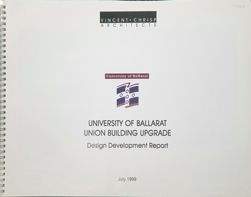
Plan, University of Ballarat Union Building Upgrade Design Development Report July 1999
... binding containing plans and report for the Union Building Upgrade ...University of Ballarat is a predecessor of Federation University A3 sized booklet with spiral binding containing plans and report for the Union Building Upgradeuniversity of ballarat, union building upgrade, design developement report, vincent chrisp architects -
 Federation University Historical Collection
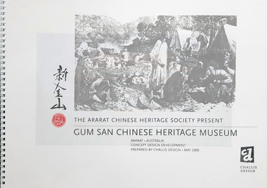
Plan, The Ararat Chinese Heritage Society Present Gum San Chinese Heritage Museum Concept Design and Development
... Museum Concept Design and Development Plan ...Dick de Fegley who was on the University of Ballarat Council was highly involved with the development of Gum San Museum. University of Ballarat is a predecessor of Federation University.A3 document containing plans and information pertaining to the development of Gum San Chinese Heritage Museumdick de fegely, gum san chinese heritage museum, challis design, ararat chinese heritage society -
Federation University Historical Collection
Book - Book - Scrapbook, Ballarat School of MInes: Scrapbook of Newspaper Cuttings, Book 36, July 1988 to September 1988
Collection of newspaper articles related to Ballarat School Of Mines.They cover activities and advertisements for staff. The papers concerned are The Courier, Ballarat, The Australian, The Age over the period of 8 July 1988 to 14 September 1988.Book with yellow cover, front, spiral bound. teaching positions advertised, pre-employment courses, courses available, enrolment for smb courses, funding for targeted apprenticeship access program, education minister caroline hogg, small business resource centre, manager gerardine christou, cultivator for farming course, radio station relocates in tippett hall smb, training for goldminers, training emphasisin new era, james oddie and development of ballarat, growing awareness on adult illiteracy, conference in ballarat, careers expo ballarat, smb course to aid disabled, awards to top apprentices, karen willison vacc first, fire tech diploma course, smb open day, affirmative action plans being developed at smb and bcae, rachel herreen wins logo competition, richard sutton, henry sutton, fuel miser event, work skill competition, ceramic tiles to form mural, motor mechanic awards, panel beating awards, local four in line for skill graduation, farming apprentice damian everard, percussionist peter cobb -
Federation University Historical Collection
Book - Book - Scrapbook, Ballarat School of MInes: Scrapbook of Newspaper Cuttings, Book 47, March 1991 to May 1991
Collection of newspaper articles related to Ballarat School Of Mines.They cover activities and advertisements for staff. The papers concerned are The Courier, Ballarat, The Australian, The Age over the period of 2 March 1991 to 24 May 1991.Book with yellow cover, front, spiral bound. teaching positions advertised, pre-employment courses, courses available, enrolment for smb courses, education under threat in country, apprenticeship system threatened, students work for community and industry, jason williams - roger keen - jamie walker, metalworks finals, tools to help disabled, neville french local potter, wayne strong new inskill manager, smb music program for children, jean read and helen fairhall, students plant an elm, austin mccallum special development school, heather horrocks and bruce stalley, adult literacy resource centre, motivation is the key, catherine mccann, autumn music in the gardens, bradley slater and lana zylan, adam fleming plumbing and gas fitting award, meg and rosalie barry, native garden honors former apprentice, ballarat library use increased, adam lindsay gordon cottage, extensions to child care centre, jack barker, smb director praises staff, damian smith top apprentice, trimathon planned, christopher sanders potter, jill simmons and john o'laughlin ceramics students, alfred mica smith -
 Conservation Volunteers
Key Document: First Green Corps National Conference, Canberra, 21-24 February 1998, Conference Organisers David Clark and Mark Purcell, Proceedings of First Green Corps National Conference, Canberra, 21-24 February 1998
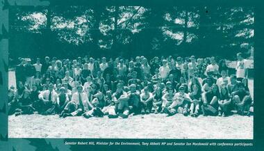
In March 1995 ATCV had circulated a proposal for an ‘Australia Corps’. The proposal emerged over time from ATCV board and staff through debate and experience. ATCV Board member Alan Wright had written earlier: “There is in our society a terrible vacuum for adolescents to give expression to their independence and idealism in a constructive way, a chance to try themselves out independent of their parents/teachers in adult roles.” ATCV’s Brisbane office manager Phil Harrison had first been involved with ATCV as a volunteer from UK, drew together ideas about an ‘Australia Corps’, that had been discussed with Alan Wright, John Fenton and others at the ATCV staff/board planning workshop at Sorrento in December 1993 and “…based upon our experience and participation in the LEAP program and observations of Conservation Corps around the world”. The concept of a six-month program for young people with a training wage and accredited training which encouraged both competencies and personal development emerged, with a standard format of ten participants working fopr six months under the direction of a supervisor. The ‘Australia Corps’ proposal was widely distributed to Federal, State and Territory parliamentarians and received positive feedback. The Liberal Party, then in Opposition, included the idea of a “Green Army” in their environmental policy, placing more emphasis on environmental outcomes and less on job creation than the Keating ALP Government had. A young and up-and-coming parliamentarian, Tony Abbott MP, was enthusiastic and was to visit several ATCV projects (both before and after Green Corps started) to learn about their workings direct from volunteers and CVA staff. Several times he visited projects with Ian Smith project and Ian recalls being impressed by the efforts he made to talk at length with all participants. Tony Abbott took a personal interest in the progress of Green Corps. Colin Jackson and Phil Harrison were guests of Abbott in Parliament House, Canberra, on the evening of 20 August 1996. The Federal Treasurer, Peter Costello, announced in his first Budget Speech that: - “the Government will provide $42 million over the next 3 years to establish the Green Corps. The Green Corps will be open to young Australians aged 17 to 20 to demonstrate their commitment to the environment by working on projects to preserve and restore Australia's natural environment and cultural heritage. The projects will also contribute to their career and employment prospects through training, skills development, work experience and personal development.” ATCV’s chief executive officer Colin Jackson worked with senior staff Madeline Townsend, Garry Snowden, Phil Harrison, and John Fenton to fine-tune the ATCV proposal. On the strength of unique national coverage and credible record ATCV went on to win the tender to administer and manage the day-to-day operations of the Green Corps program for five years (1997-2002). Winning a $36 million contract was a big breakthrough for ATCV. Fourteen years before, a small non-profit group had started in Ballarat in country Australia with a vision – but little else. Its key people had shaped opinion and won political support for a concept. There was about to be transformation from hand-to-mouth existence into a nation-wide business with resources to build for the long term. This documents records many positive comments about Green Corps and ATCV's implementation of it.24pp illustrated booklet printed in green and some gold.atcv green corps australia-corps tony abbott mp phil-harrison -
 Flagstaff Hill Maritime Museum and Village
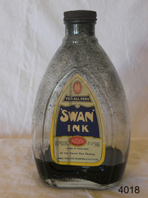
Container - Ink bottle, MABIE TODD & Co. (Aust.) Pty. Ltd, Second half of 19th Century or first half of the 20th Century
A Brief History Of Mabie Todd Ltd The company originated in America from the beginnings during the 1860s when a Mr. Todd and a Mr. Mabie began making pencil cases and pen holders in New York. Later they were joined by the Bard Brothers who made Gold nibs and by 1873 the company of Mabie Todd and Bard were established in New York. By 1878 the first patent was filed for the design and manufacture of a fountain pen, achieved under the design leadership of one William Washington Stewart. The first Swan fountain pen followed just 6 years later in 1884 with an over-under feed with ink delivery assisted by a twisted silver wire. This same year an office had been established in the UK with a showroom in Cheapside, London. The UK was being supplied with a steadily increasing supply of pens from New York and by 1905 new, larger showrooms were established in High Holborn. By this time the Swan pen had become synonymous with fountain pens at large. In 1906 the name of Bard was dropped in the US and the UK company subsequently adopted the title Mabie Todd & Co. New York. In 1907 British production began, using imported nibs from New York and whilst the company in the UK flourished, the business in the US started to diminish under stiff competition from new manufacturers.. By 1915 manufacturing was doing well in England from a factory in Weston Street, London and the New York company agreed to sell the rights to all European and Colonial business to Mabie Todd & Company Ltd of England. From then onwards, the development of the range mostly followed, rather than led the interests of the markets they were supplying. Even during the First World War the business continued to flourish. with factories in both London and Liverpool. At the end of 1919 a new expansion plan saw the establishment of a new Headquarters in Oxford Street, London. Throughout this period, some components were continuing to be imported from America, but gradually these diminished and during the 20s and 30s manufacturing facilities were expanded and by the end of the 1930s Mabie Todd were in full production, manufacturing pens in its London factory, gold nibs in Birmingham and ink in Liverpool. Another new headquarters grew out of this period of abundance and market domination. when in 1936 they moved into Sunderland House in Mayfair, London, a highly prized mansion building. Disaster struck early in the Second World War. Its prestigious Sunderland House headquarters was destroyed during the blitz, followed by destruction of its main factory in Harlesden, North London. Some machinery was saved and able to be used at another factory premises in the City, but like many other 'non essential' manufacturing, the main production was centred on wartime components such as rocket fuses and ammunition. After The War, in 1945 they moved out of their City premises to Park Royal and eventually in 1946 proper fountain pen production was resumed. In 1948 the company decided to go public. But at the time they had no plans to enter into the market for the now growing interest in ballpoint pens, the result was the beginning of their slide into obscurity and subsequent demise. They became Biro Swan in 1952 following a large share purchase by Biro Pens. Even though at this time they had just launched their new high profile Calligraph range to join the competition for the new market associated with a craze for italic writing, fountain pen manufacture under the new company was to suffer a lack of real support. The restyled ranges of 1956 failed to ignite market interest and with diminishing quality, the end of the Mabie Todd story was inevitable. After 80 years of Swan pens, the book was closed.This bottle of ink would have been supplied to schools. After a child was deemed old enough to progress from just using slate and board, he/she would have been supplied with a pen shaft made of wood and with a very basic metal nib. The ink bottle would be used to fill up the individual inkwells. This operation would have been conducted by the teacher him/herself, or by an older pupil under the close eye of the teacher.Ink bottle clear glass with 'Swan Ink' paper label. Has rusted screw on top & black ink inside.Label has 'Mabel Todd' manufacturer's logo at top,; 'Swan Ink' name clearly shown; 'Made in England' printed clearly; and 'Mable Todd & Co Ltd, London & Liverpool' printed at base of label.flagstaff hill, warrnambool, shipwrecked-coast, flagstaff-hill, flagstaff-hill-maritime-museum, maritime-museum, shipwreck-coast, flagstaff-hill-maritime-village, ink, bottle, mabie todd ltd -
 Greensborough Historical Society
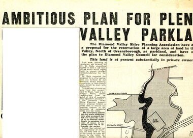
Newspaper Clipping - Digital Image, Ambitious plan for Plenty Valley Parklands 1965, 05/11/1965
In 1965, the Diamond Valley Shire planning association recommended to Council that a large area of land north of Greensborough be acquired for Parkland. The idea of a Civic Centre was included with a map of the area from Grimshaw Street in the south to the MMBW pipeline reserve in the north. Includes a suggested new site for the local school, near Yando Street. This area is now part of the Plenty River Trail.An example of developments in the Greensborough area during the period of Shire of Diamond ValleyNews clipping, black and white text and map. Scanned in 3 parts.shire of diamond valley, civic drive greensborough, yando street greensborough, partingtons flat, plenty river trail -
 Greensborough Historical Society
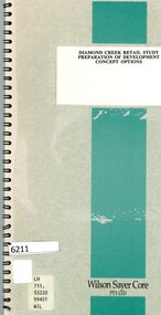
Booklet, Wilson Sayer Core Pty Ltd, Diamond Creek retail study: preparation of development concept options, August 1989
Planning options for an extended retail development in Diamond Creek 1989.12 p. text, 12p. plans, spiral bound non-fictiondiamond creek, shire of diamond valley, retail developments -
 Greensborough Historical Society
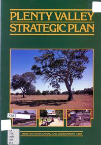
Booklet - Leaflet, Plenty Valley strategic plan, August 1989
A 1989 planning document for the Plenty Valley growth area, as much of it moved from rural to residential zoning.8 p., text and col. illustrationsplenty valley, urban development, plenty river, shire of diamond valley, whittlesea -
 Greensborough Historical Society
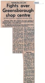
Article - Newspaper Clipping, The Herald, Fights over Greensborough shop centre, 03/02/1977
This article covers some of the issues when the development of Greensborough Plaza was in the planning stages in 1977.Shows local resistance to the building of a large shopping complex in Greensborough.News article, black textgreensborough plaza, shire of diamond valley, bob fell -
 Greensborough Historical Society
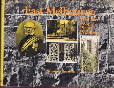
Book, Craftsmen Press, East Melbourne: 1837-1977: people, places, problems, 1977
... development. East Melbourne town planning melbourne A history of early ...A history of early development and more recent redevelopment in East Melbourne, from a town planning perspective.177 p., illus., maps.non-fictionA history of early development and more recent redevelopment in East Melbourne, from a town planning perspective.east melbourne, town planning, melbourne -
 Greensborough Historical Society
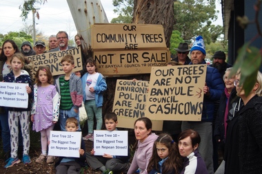
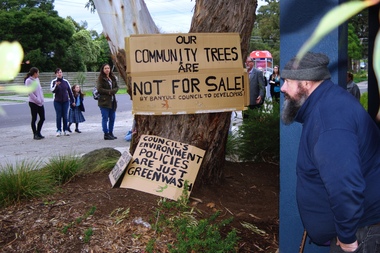
Photograph - Digital Image, Marilyn Smith, Diamond Valley Tree Protest 2019, 25/07/2019
A redevelopment of the Diamond Village area included a multi storey apartment block which required the removal of this tree (Tree 10) on the plans. A VCAT decision ruled that the development be no higher than 4 storeys, and a maximum of 15 dwellings. This photograph shows local residents protesting at the development and removal of tree in July 2019.Digital copy of colour photographdiamond village shopping centre, diamond village, nepean street watsonia -
 Greensborough Historical Society
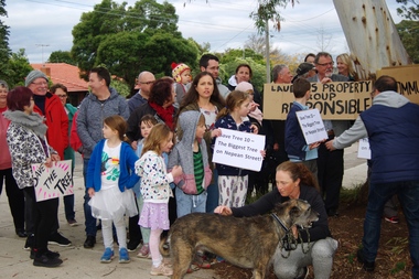
Photograph - Digital Image, Diamond Valley Tree Protest 2019 - people, 25/07/2019
A redevelopment of the Diamond Village area included a multi storey apartment block which required the removal of this tree (Tree 10) on the plans. A VCAT decision ruled that the development be no higher than 4 storeys, and a maximum of 15 dwellings. This photograph shows local residents protesting at the development and removal of tree in July 2019.Digital copy of colour photographsdiamond village shopping centre, diamond village, nepean street watsonia -
 Greensborough Historical Society
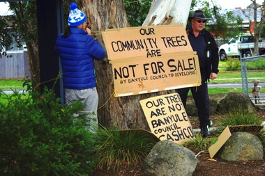
Photograph - Digital Image, Diamond Valley Tree Protest 2019 - signs, 25/07/2019
A redevelopment of the Diamond Village area included a multi storey apartment block which required the removal of this tree (Tree 10) on the plans. A VCAT decision ruled that the development be no higher than 4 storeys, and a maximum of 15 dwellings. This photograph shows local residents placing protest signs at the base of the tree in July 2019.Digital copy of colour photographsdiamond village shopping centre, diamond village, nepean street watsonia -
 Greensborough Historical Society
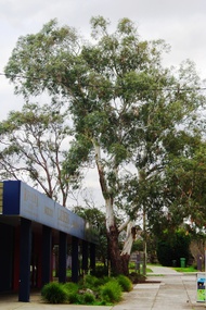
Photograph - Digital Image, Diamond Valley Tree Protest 2019 - Tree 10, 25/07/2019
A redevelopment of the Diamond Village area included a multi storey apartment block which required the removal of this tree (Tree 10) on the plans. A VCAT decision ruled that the development be no higher than 4 storeys, and a maximum of 15 dwellings. This photograph shows Tree 10 in situ in July 2019.Digital copy of colour photographdiamond village shopping centre, diamond village, nepean street watsonia -
 Greensborough Historical Society
Photograph - Digital Image, Diamond Valley Tree Protest 2019 - GHS members, 25/07/2019
A redevelopment of the Diamond Village area included a multi storey apartment block which required the removal of this tree (Tree 10) on the plans. A VCAT decision ruled that the development be no higher than 4 storeys, and a maximum of 15 dwellings. This photograph shows several GHS members at the protest in July 2019.Digital copy of colour photographsdiamond village shopping centre, diamond village, nepean street watsonia -
 Mission to Seafarers Victoria
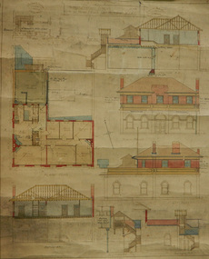
Plan - Architectural drawings, Walter Butler, 1916
An original group of plans drawn by Walter Butler who was also the architect of the Central Institute, Siddeley Street in 1906 and the Mission to Seamen building at 717 Flinders St that is still in use today. The early Port Melbourne onshore Mission gradually transformed from a 'wooden shack' to a one storey brick building designed by architect Frederick Williams in 1888. The St Nicholas chapel was added in 1915. Walter Butler was commissioned to add a second storey in 1917. The building retained its functions until 1937 when the Art Deco Mission, designed by Morris was built. The building has survived as a structure into the 21st century, and was incorporated as part of a multi-apartment development. Historical architectural record of Walter Butler's work. Walter Butler was a renowned architect and friend of the Fairfax family.Coloured architect's drawings of the proposed plans for Chaplain's Residence at Port Melbourne on heavy parchment. Including elevation drawings, floor plans and cross sections as well as architect's notes and measurements.Embossed architect's stamp in top right and left corners and bottom right corner "Walter R Butler [indecipherable] Melbourne" Printer's stamp on bottom right hand corner of rear "Printed by J. Creffield Propy. LTD. RIALTO, 493-5 Collins St. Melbourne"plans, walter richmond butler (1864–1949), mission to seafarers, chaplains residence, beach street, nott street, port melbourne, mission to seamen, frederick williams -
 Greensborough Historical Society
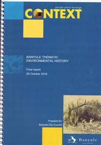
Book, Context (GML Heritage Victoria Pty Ltd), Banyule thematic environmental history: final report, 2018_10
Report on and development of heritage themes relating to forms and places in the City of Banyule area, including places associated with Aboriginal people. Final report prepared for Banyule City Council by Context.82 p., spiral bound, colour and black and white photographs and planscity of banyule, heritage places -
![Document collection, Watsonia development [Lambourn and Devonshire Roads], 2019_](/media/collectors/4f729f5697f83e03086015b8/items/5d82cea121ea6712b80a7cdd/item-media/5d8579dd21ea67168c696120/item-fit-380x285.jpg) Greensborough Historical Society
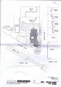
Greensborough Historical SocietyDocument collection, Watsonia development [Lambourn and Devonshire Roads], 2019_
In 2003, a proposal for a 5 storey building on the corner of Lambourn and Devonshire Roads Watsonia for an apartment complex, medical centre, shops and cafe was approved by VCAT, despite strong opposition by local residents. The proposal did not proceed. In 2019 a proposal for a 2 storey medical centre, cafe and residence was approved for the site and construction commenced. Collection of documents comprising history of development proposals by Rosie Bray, concept illustrations, archtect's plans, photograph and copy of newspaper clipping.watsonia, lambourn road watsonia, devonshire road watsonia -
 Greensborough Historical Society
Plan, brucehenderson architects, Plans for proposed development at Devonshire and Lambourne Roads Watsonia 2004, 2004_01
... Plenty Lower Plenty melbourne Amended plans for a mixed use ...Amended plans for a mixed use development corner Devonshire Road and Lambourn Road Watsonia in 2004.23 p., black & white and colour plans with covering letterwatsonia, lambourn road watsonia, devonshire road watsonia -
 Greensborough Historical Society
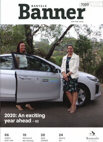
Magazine, Banyule Banner Jan-Feb 2020, 2020_01
The Banyule Banner is published bi-monthly by Banyule City Council to advertise upcoming events in the City of Banyule and to report on past events. This edition covers future plans for Banyule, including environmental issues and developments with the North East Link project. A record of events within the City of Banyule.20 pages (approx.), colour illustrations. 3 copies.banyule banner, north east link, banyule council -
 Greensborough Historical Society
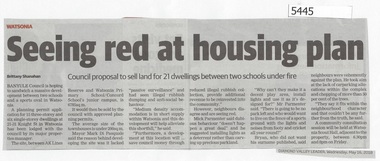
Newspaper Clipping, Diamond Valley Leader, Seeing Red at Housing Plan, 16/05/2018
Banyule Council is hoping to sandwich a massive development between two schools and a sports oval in Watsonia.News article 1 page, black text.watsonia, knight street watsonia, concord school, watsonia primary school, residential development, banyule city council -
 Greensborough Historical Society
Newspaper Clipping, Diamond Valley News, Apollo Parkways School may start with 220 pupils, 24/10/1978
In 1978 Apollo Parkways Primary School [AP5184] was in the planning stages. In this article the Principal is named and plans for permanent buildings are discussed. The school opened in 1979.Information about the development of a new school in the Greensborough area.Photocopy of newspaper article,Date written on side.apollo parkways primary school, frank miller