Showing 25583 items matching "plenty-township-estate"
-
 Stawell Historical Society Inc
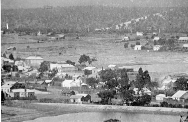
Photograph, Stawell Township looking towards Wild Cat Hill 1880
Stawell Township looking towards Wild Cat Hill 1880stawell -
 Stawell Historical Society Inc
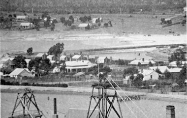
Photograph, Panorama of Stawell Township taken from Big Hill
Stawell Township looking towards Wild Cat Hill 1880stawell -
 Malmsbury Historical Society
Photograph (Item), Malmsbury Township From Western Vantage Point, Malmsbury ca1950
People - Young Family Buildings - Township/Football Oval/Willows -
 Ringwood and District Historical Society
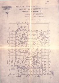
Document - Folder, Land Sale, Parkhaven Estate, Heathmont, Victoria - 1968
Manilla folder containing 2-page foolscap size typewritten summary of Parkhaven Estate Heathmont multiple release allotment prices and two maps headed Plan of Subdivision - Part of Crown Portion 13, Parish of Ringwood. Subdivision includes Cuthbert Street, Waterloo Street, Sunset Drive, Markhill Place, Parkhaven Drive, Bayley Close and Blenheim Street. Agents - Consolidated Home Industries Limited, Lower Dandenong Road, Braeside, Vic., Phone 91-9791. Rep - Bruce Grant.Accompanying handwritten sales note researched in 2024 by Richard Carter - Carter Real Estate - "Generally $2500 to $4000 per lot". -
 Ringwood and District Historical Society
Photograph, Parish Map - Township of Ringwood - 1890
Written on backing sheet, 'SLV Parish Map Collection. Vol.67, Fol. 43, 1890'. Catalogue card reads, 'SLV Parish Map Collection 1890. (Township of Ringwood). -
 Kew Historical Society Inc
Plan - Subdivision Plan, J R Mathers & McMillan, Glenarbor Estate, 1934
Pru Sanderson, in her groundbreaking ‘City of Kew Urban Conservation Study : Volume 2 - Development History’ (1988), summarised the periods of urban development and subdivisions of land in Kew. The periods that she identified included 1845-1880, 1880-1893, 1893-1921, 1921-1933, 1933-1943, and Post-War Development. These periods were selected as they represented periods of rapid growth or decline in urban development. An obvious starting point for Sanderson’s groupings involved population growth and the associated economic cycles. These cycles also highlighted urban expansion onto land that was predominantly rural, although in other cases it represented the decline and breakup of large estates. A number of the plans in the Kew Historical Society’s collection can also be found in other collections, such as those of the State Library of Victoria and the Boroondara Library Service. A number are however unique to the collection.The Kew Historical Society collection includes almost 100 subdivision plans pertaining to suburbs of the City of Melbourne. Most of these are of Kew, Kew East or Studley Park, although a smaller number are plans of Camberwell, Deepdene, Balwyn and Hawthorn. It is believed that the majority of the plans were gifted to the Society by persons connected with the real estate firm - J. R. Mathers and McMillan, 136 Cotham Road, Kew. The Plans in the collection are rarely in pristine form, being working plans on which the agent would write notes and record lots sold and the prices of these. The subdivision plans are historically significant examples of the growth of urban Melbourne from the beginning of the 20th Century up until the 1980s. A number of the plans are double-sided and often include a photograph on the reverse. A number of the latter are by noted photographers such as J.E. Barnes.The little-known Glenarbor Estate comprised 23 allotments bordering Wellington and Denmark Streets and Fenton Avenue. The auction of the allotments in the Estate was held in the Kew Recreation Hall. The purported advantages to Kew are identified on the plan, such as the close proximity of the entrance to the Kew Railway Station and access to shops in Denmark Street. Due to its location, the subdivision was pitched at commercial as well as residential purchasers. The Estate was to cause a crisis in the Kew Council as a majority of councillors voted on 29 May to acquire the entire Estate as the location of a new Town Hall. The Estate was said to be valued at £50,000. A later meeting was to rescind the vote, instead opting for the compulsory acquisition of South Esk on the corner of Charles Street and Cotham Road. That acquisition was to be overturned by the State Government. The debate about the purchase of the Glenarbor Estate by Council coincided with the decision to widen High Street on the South side between Cotham Road and the Junction."D"subdivision plans - kew, glenarbor estate, wellington street, denmark street -
 Stawell Historical Society Inc
Photograph, Mafeking Goldfield at Mt William with Businesses in the township c1900
Mafeking Goldfield Mt William Mining Scene c1900. Businesses in the township.stawell -
 Kew Historical Society Inc
Plan - Subdivision Plan, Cotham Vale Estate, 1919
Pru Sanderson, in her groundbreaking ‘City of Kew Urban Conservation Study : Volume 2 - Development History’ (1988), summarised the periods of urban development and subdivisions of land in Kew. The periods that she identified included 1845-1880, 1880-1893, 1893-1921, 1921-1933, 1933-1943, and Post-War Development. These periods were selected as they represented periods of rapid growth or decline in urban development. An obvious starting point for Sanderson’s groupings involved population growth and the associated economic cycles. These cycles also highlighted urban expansion onto land that was predominantly rural, although in other cases it represented the decline and breakup of large estates. A number of the plans in the Kew Historical Society’s collection can also be found in other collections, such as those of the State Library of Victoria and the Boroondara Library Service. A number are however unique to the collection.The Kew Historical Society collection includes almost 100 subdivision plans pertaining to suburbs of the City of Melbourne. Most of these are of Kew, Kew East or Studley Park, although a smaller number are plans of Camberwell, Deepdene, Balwyn and Hawthorn. It is believed that the majority of the plans were gifted to the Society by persons connected with the real estate firm - J. R. Mathers and McMillan, 136 Cotham Road, Kew. The Plans in the collection are rarely in pristine form, being working plans on which the agent would write notes and record lots sold and the prices of these. The subdivision plans are historically significant examples of the growth of urban Melbourne from the beginning of the 20th Century up until the 1980s. A number of the plans are double-sided and often include a photograph on the reverse. A number of the latter are by noted photographers such as J.E. Barnes.The Cotham Vale Estate was a subdivision of land between Alfred, Thomas, Rowland and John Streets. It was promoted in the same time as the nearby Normanby Heights Estate. Cotham Vale included 28 allotments. Contemporary newspaper advertisements noted that the Estate ‘is most conveniently situated in a well elevated position, only 2 minutes from Cotham rd. Electric Cars, penny section to Kew station’.subdivision plans - kew, cotham vale estate, rowland street -- kew (vic.), thomas street -- kew (vic.), john street -- kew (vic.) -
 Whitehorse Historical Society Inc.
Document, Mitcham Hills Estate, n.d
Sale brochure for 'Mitcham Hills Estate',Sale brochure for 'Mitcham Hills Estate', 74 sites bordered by McKeon and Quarry Roads, to the order of Commander H.E. Turner and Mrs Turner. Agent: Drake & Co.. With 'List of Sale Prices'.Sale brochure for 'Mitcham Hills Estate',land subdivision, mitcham hills estate, mckeon road, mitcham, quarry road, endeavour street, moresby street, beaufort street, turner, harold exton, cmdr., (mrs), drake & co. -
 Clunes Museum
Map - CLUNES MAP SHOWING STREETS AND LOT NUMBERS
PURCHASED FROM DONORMAPS, PARISH OF CLUNES, CLUNES TOWNSHIPCLUNES TOWNSHIP AND STREETSlocal history, document, maps, clunes township -
 Kiewa Valley Historical Society
Folder - Early History of Mt Beauty Township, Early History of Mt Beauty Township compiled with contributions by residents of Mt Beauty
To Compile the history of Mt Beauty Township residents were asked to contribute with their reminiscences. Thick white folder held by 2 steel rings at the spine. The first page is an index listing the 'Folio Number' (14) and Description of the content in each folio. Each folio is in a clear plastic sleeve. Some folios are hand written and some are typed.In blue pen Folios 13 and 14 have 'Voters List/Voters Roll' with description added to the list. george paterson, adrian rufenacht, roly wilson, roly whitehead, jim gardner, ron white, mt beauty -
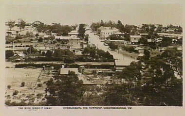 Greensborough Historical Society
Photograph - Digital Image, Rose Series Postcards, Overlooking the township of Greensborough 1929, 1929_
Photograph of Greensborough taken from a Rose Series postcard titled "Overlooking the township of Greensborough".Historic view of GreesboroughDigital copy of black and white photographgreensborough 1929, rose series postcards -
 Kew Historical Society Inc
Plan - Subdivision Plan, Doona Estate, Toorak, 1929
The Kew Historical Society collection includes almost 100 subdivision plans pertaining to suburbs of the City of Melbourne. Most of these are of Kew, Kew East or Studley Park, although a smaller number are plans of Camberwell, Deepdene, Balwyn and Hawthorn. It is believed that the majority of the plans were gifted to the Society by persons connected with the real estate firm - J. R. Mathers and McMillan, 136 Cotham Road, Kew. The Plans in the collection are rarely in pristine form, being working plans on which the agent would write notes and record lots sold and the prices of these. The subdivision plans are historically significant examples of the growth of urban Melbourne from the beginning of the 20th Century up until the 1980s. A number of the plans are double-sided and often include a photograph on the reverse. A number of the latter are by noted photographers such as J.E. Barnes.The Doona Estate subdivision of 1929 created 11 new allotments bordered by Glenferrie Road, Stonnington Place, Cross and Church Streets. On the right of the plan, the location of ‘State Govt. House’ is noted. Stonnington was to be maintained as Victoria’s Government House until 1931, two years after the Doona Estate subdivision was released.subdivision plans - toorak, doona estate -
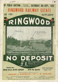 Ringwood and District Historical Society
Flyer, Subdivision Advertisement - Ringwood Railway Estate Public Auction - 1923
Refer also to Reg. No. 5185 for Ringwood Railway Estate final section release (August 1924)Folded double-sided brochure advertising 85 residential allotments and brick cemented villa - Ringwood Railway Estate Public Auction on Saturday 8th September, 1923, with town photographs, location map, terms of sale, and summary of local features and services.Subdivision includes Whitehorse Road, Bon View Avenue, Grant Crescent, Heatherbrae Avenue, Burwood Avenue, and Sherbrooke Avenue. (Agents) Knight & Harwood, 315 Collins Street, Melbourne, Phones Central 10615, 10616, in conjunction with J.B. McAlpin, Opposite Railway Station, Ringwood, Phone Ringwood 7. -
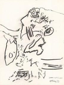
 Latrobe Regional Gallery
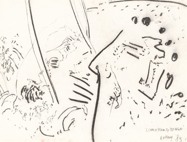
Drawing, BELLANY, John b. 1942, Port Seton d. 2013, Lower Plenty Gorge, 1983
Pastel on paperTitled, signed and dated 'Bellany '83 Lower Plenty Gorge' in lower right corner of drawing. -
 Latrobe Regional Gallery
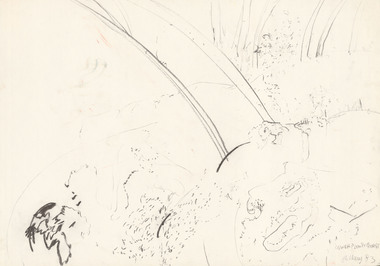
Drawing, BELLANY, John b. 1942, Port Seton d. 2013, Lower Plenty Gorge, 1983
Charcoal on paper.Titled, signed and dated 'Lower Plenty Gorge Bellany '83' in lower right corner of drawing. -
 Latrobe Regional Gallery
Drawing, BELLANY, John b. 1942, Port Seton d. 2013, Lower Plenty Gorge, 1983
Pastel on paperTitled, signed and dated 'Lower Plenty Gorge Bellany '83' in lower right corner of drawing. -
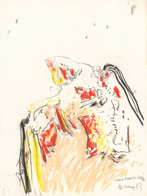
 Latrobe Regional Gallery
Drawing, BELLANY, John b. 1942, Port Seton d. 2013, Lower Plenty Gorge, 1983
Pastel on paperTitled, signed and dated 'Lower Plenty Gorge Bellany '83' in lower right corner of drawing. -
 Latrobe Regional Gallery
Drawing, BELLANY, John b. 1942, Port Seton d. 2013, Lower Plenty Gorge, 1983
Pastel on paperTitled, signed and dated 'Lower Plenty Gorge Bellany '83' in lower right section of drawing. -
 Latrobe Regional Gallery
Drawing, BELLANY, John b. 1942, Port Seton d. 2013, Lower Plenty Gorge, 1983
Charcoal on paperTitled, signed and dated 'Lower Plenty Gorge Bellany '83' in lower right corner of drawing. -
 Latrobe Regional Gallery
Drawing, BELLANY, John b. 1942, Port Seton d. 2013, Lower Plenty Gorge, 1983
Charcoal on paperTitled, signed and dated 'Lower Plenty Gorge Bellany '83' in lower right corner of drawing. -
 Latrobe Regional Gallery
Drawing, BELLANY, John b. 1942, Port Seton d. 2013, Lower Plenty Gorge, 1983
Pastel on paperTitled, signed and dated 'Lower Plenty Gorge Bellany '83' in lower right corner of drawing. -
 Greensborough Historical Society
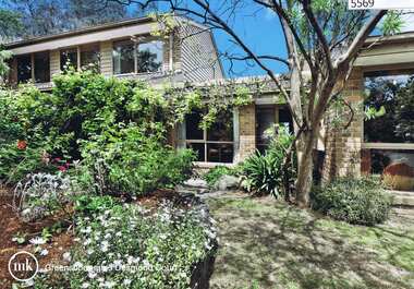
Advertising Leaflet, 5 Desmond Court Greensborough, 01/12/2012
5 Desmond Court Greensborough: 4 bedroom brick veneer home, auctioned 1 December 2012, sold for $598,000Real Estate advertising leafletdesmond court greensborough -
![Township of Lorne, and Loutitt Bay / [by] Nicholas Caire, circa 1876](/media/collectors/550653872162f11fb04854aa/items/5783458ad0cdd1176c6f0c78/item-media/578345eed0cdd1176c6f852b/item-fit-380x285.jpg) Kew Historical Society Inc
Kew Historical Society IncPhotograph, Anglo-Australasian Photographic Company, Township of Lorne, and Loutitt Bay, c. 1876
Nicholas Caire was born on Guernsey in the Channel Islands in 1837. He arrived in Adelaide with his parents in about 1860. In 1867, following photographic journeys in Gippsland, he opened a studio in Adelaide. From 1870 to 1876 he lived and worked in Talbot in Central Victoria. In 1876 he purchased T. F. Chuck's studios in the Royal Arcade Melbourne. In 1885, following the introduction of dry plate photography, he began a series of landscape series, which were commercially successful. As a photographer, he travelled extensively through Victoria, photographing places few of his contemporaries had previously seen. He died in 1918. Reference: Jack Cato, 'Caire, Nicholas John (1837–1918)', Australian Dictionary of Biography.An original, rare photograph from the series 'Views of Victoria: General Series' by the photographer, Nicholas Caire (1837-1918). The 60 photographs that comprise the series were issued c. 1876 and reinforced a neo-Romantic view of the Australian landscape to which a growing nationalist movement would respond. Nicholas Caire was active as a photographer in Australia from 1858 until his death in 1918. His vision of the Australian bush and pioneer life had a counterpart in the works of Henry Lawson and other nationalist poets, authors and painters.‘Township of Lorne, and Loutitt Bay’ : Views of Victoria (General Series) No.60 : Albumen silver photograph | Photo on card with Title and Description on reverse | Mounted 24 x 30 cm; Photo 12 x 17 cm.On Reverse: ‘Loutitt Bay is fast becoming one of the most fashionable Watering-places in Victoria, partly from its easy access by Rail, combined with the magnificent scenery to be found in the Cape Otway Ranges, and the very moderate charges of the houses of accommodation. The large house near the foreground is that of Mr. Mountjoy, which is a Restaurant. Duncan’s Hotel can be seen in the distance, on the brow of the hill.’nicholas caire (1837-1918), lorne (vic), duncan's hotel, loutitt bay, landscape photography - victoria -
 Ringwood and District Historical Society
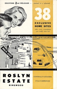
Flyer, Land Sale Brochure - Roslyn Estate, Ringwood, Vic. - circa 1960s
Land sale advertisement for 2nd release of residential sites with area map, layout of the estate, terms of sale, and summary of local facilities and services.Subdivision includes Daisy Street, Vale Street, Joan Court, Christine Court, and Westmore Drive. (Agent) Heathmont Estate Agency, 103 Canterbury Road, Heathmont. (Phone) WU7808-9. Brochure also includes map with streets marked as "Sold" - Reilly Street, Adrian Court, Daisy Street, Jarma Road, Joel Court, and Ross Court, with comment that "all home sites in the first release have already been sold, and most built on." -
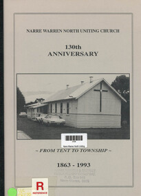 Narre Warren and District Family History Group
Book, Max Thomson, Narre Warren North Uniting Church. 130th Anniversary - From Tent to Township. 1863 - 1993, 1993
Written for the 130th anniversary the book chronicles the church's history and the people who have been associated with it.12 pagesnon-fictionWritten for the 130th anniversary the book chronicles the church's history and the people who have been associated with it.narre warren north (vic.), narre warren north uniting church -
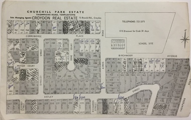 Kew Historical Society Inc
Plan - Subdivision Plan, Churchill Park Estate, Templestowe
Historic subdivision plan of the Churchill Park Estate in Templestowe.Undated subdivision plan advertising the Churchill Park Estate inTemplestowe. Streets identified in the plan include: Corroboree Place, Astley Street, Jeffrey Street, Airds Road, Dove Court, Potter Court, Thompsons Road, Richards Street, and Birchwood Avenue. This record includes a copy of the price list.Annotations in ink on the plan by agentsubdivision plans - templestowe (vic), churchill park estate - templestowe (vic) -
 Kew Historical Society Inc
Plan - Subdivision Plan, Flower Farm Estate, East Kew, 1922
Pru Sanderson, in her groundbreaking ‘City of Kew Urban Conservation Study : Volume 2 - Development History’ (1988), summarised the periods of urban development and subdivisions of land in Kew. The periods that she identified included 1845-1880, 1880-1893, 1893-1921, 1921-1933, 1933-1943, and Post-War Development. These periods were selected as they represented periods of rapid growth or decline in urban development. An obvious starting point for Sanderson’s groupings involved population growth and the associated economic cycles. These cycles also highlighted urban expansion onto land that was predominantly rural, although in other cases it represented the decline and breakup of large estates. A number of the plans in the Kew Historical Society’s collection can also be found in other collections, such as those of the State Library of Victoria and the Boroondara Library Service. A number are however unique to the collection.The Kew Historical Society collection includes almost 100 subdivision plans pertaining to suburbs of the City of Melbourne. Most of these are of Kew, Kew East or Studley Park, although a smaller number are plans of Camberwell, Deepdene, Balwyn and Hawthorn. It is believed that the majority of the plans were gifted to the Society by persons connected with the real estate firm - J. R. Mathers and McMillan, 136 Cotham Road, Kew. The Plans in the collection are rarely in pristine form, being working plans on which the agent would write notes and record lots sold and the prices of these. The subdivision plans are historically significant examples of the growth of urban Melbourne from the beginning of the 20th Century up until the 1980s. A number of the plans are double-sided and often include a photograph on the reverse. The subdivision called the ‘Flower Farm Estate’ in Kew East occurred in 1922. It included 61 lots on either side of Boorool Road between High Street and Harp Road. In an advertisement in The Argus in the same year, the proximity of the estate to the newly erected shops at the corner of Harp Road and High Street is noted. The Flower Farm Estate and similar subdivisions in Kew East were assisted by the extension of the High Street tramline in 1924.subdivision plans - east kew, flower farm estate, high street - kew east (vic.), boorool road -- kew east (vic.), harp road -- kew east (vic.) -
 Kew Historical Society Inc
Map, Robert Russell, Map Shewing the Site of Melbourne and the Position of the Huts & Buildings Previous to the Foundation of the Township by Sir Richard Bourke in 1837
Map shows the first layout of Melbourne by Government surveyor Robert Russell, who accompanied Governor Richard Bourke in 1837. The surveyed blocks extend from present-day Flinders Street to Lonsdale Street, and Spring Street to Spencer Street, with extensive vacant land west to a salt lake (afterwards Batman's Swamp, later drained), north beyond Flagstaff Hill and south towards South Melbourne. Vegetation coverage is indicated, and tracks and existing buildings and cultivated land are shown.Printed map was created by Day & Haghe, Lithographers to the Queen, sometime after 1838, when the company received its Royal appointment. Copies of the 1837 map exist in several major map collections in Australia; most are uncoloured. This particular map is the earliest in the Kew Historical Society's map collection. It is a nationally significant artefact. Black and white lithographed map hand-coloured in blue and yellow gouache of the town of Melbourne in 1837. In contrast to the original lithograph, the river and the township blocks are coloured blue and yellow. A similar, partly coloured copy is in the collection of the University of Melbourne.maps - melbourne - 1830s, governor sir richard bourke, robert russell - surveyor, cartography -
 Kew Historical Society Inc
Plan - Subdivision Plan, Central Park Estate, Deepdene - Camberwell, 1923
The Kew Historical Society collection includes almost 100 subdivision plans pertaining to suburbs of the City of Melbourne. Most of these are of Kew, Kew East or Studley Park, although a smaller number are plans of Camberwell, Deepdene, Balwyn and Hawthorn. It is believed that the majority of the plans were gifted to the Society by persons connected with the real estate firm - J. R. Mathers and McMillan, 136 Cotham Road, Kew. The Plans in the collection are rarely in pristine form, being working plans on which the agent would write notes and record lots sold and the prices of these. The subdivision plans are historically significant examples of the growth of urban Melbourne from the beginning of the 20th Century up until the 1980s. A number of the plans are double-sided and often include a photograph on the reverse. A number of the latter are by noted photographers such as J.E. Barnes.An agent’s board on which parts of an advertisement for the Central Park Estate have been pasted. [The State Library of Victoria holds a complete plan]. Whereas the original plan included black and white photographs and effusive prose about the virtues of the Estate, the item in our collection includes only the actual blocks. The agent has annotated particular blocks to indicate that they have been sold.subdivision plans - deepdene - camberwell, central park estate