Showing 4461 items
matching point
-
 Flagstaff Hill Maritime Museum and Village
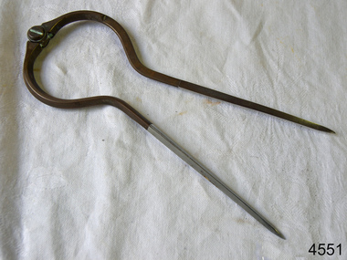
Dividers, Early 20th Century
Dividers are used by navigators to measure the distance between two points on a map or chart. Each point of the divider is places on a map point, then the distance between the points of the divider is measured against the scale of the chart or map. This helps determine the ship's path of travel, the distance travelled and the current location.Not very significant as not associated with any historical event or person, same pattern of dividers is available today from many retail outlets. Also item was probably made around 1940s to 1950sDividers; brass navigator's dividers with fine, stainless steel points. Made in Britain by W & H C (inscription). This navigational tool is used by a ship's navigator to mark the ship's position. Each end point of the divider is placed on a position on a chart or map, then the length between the points of the divider is measured on the chart's scale.Inscribed "British Made" and "W & H C". flagstaff hill, warrnambool, shipwrecked-coast, flagstaff-hill, flagstaff-hill-maritime-museum, maritime-museum, shipwreck-coast, flagstaff-hill-maritime-village, navigational dividers, navigational tool, dividers made by w & hc, w & hc britain -
 Nhill Aviation Heritage Centre
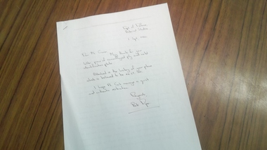
Letter to Ian Cramer
Ian Cramer donated the plane Avro Anson LT710 to the RAAF museum Point Cook in 1980. The plane was purchased war surplus from the Nhill Aerodrome after the war and stored in a shed on the farm at Woorak. A short time later Mr Cramer forwarded more remnants of the aircraft to Point Cook and this letter of thanks and a short history paper was received.History of an Avro Anson that was disposed from the RAAF from Nhill aerodrome.Copy of paper written by Bob Piper of the Dept Defence Historical Studies. Two A4 pages titled "Aggie Arrives Home", history of Anson LT710. Includes cover letter to Ian Cramer who donated the remnants of LT710 to the RAAF museum Point Cook in 1980.Aggie Arrives Home by Robert Kendall Piper -
 Mont De Lancey
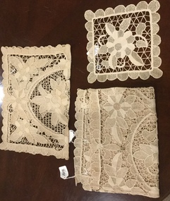
Table runner. Tray cloth, Mat
Refer to: 1107, 1108, 1109.One cream table runner, worked in point lace, with a scalloped point lace edging. One cream tray cloth, worked in point lace, with a scalloped point lace edging.table accessories, table runners, tableware. -
 Ballarat Tramway Museum
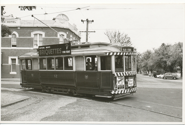
Photograph - Black & White Photograph/s, Lloyd Rogers, 21/03/1962 12:00:00 AM
Yields information about the appearance of tram No. 12 in the early 1960's and the Sturt St streetscape.Black and white photograph of Ballarat tram 12 turning from Sturt St into Ripon St with the destination of View Point. Dated 21/3/1962. Printed on Agfa Gevaert paper in a postcard format. No. 12 has a roof advert for SEC Briquettes, and dash panel adverts for Mutual Homes and The Age. In the background is the Western Hotel. Photo by Lloyd Rogers.In ink "Ballarat car 12 on View Point Road 21/3/1962 and 6/25". In pencil: "12 - ex 71 J"trams, tramways, sturt st, ripon st, view point, tram 12 -
 Flagstaff Hill Maritime Museum and Village
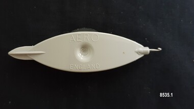
Domestic object - Tatting Shuttle, Aero Needles Group Ltd, Mid to late 20th century
Tatting is a form of knotted lace making using thread and a small shuttle. Twisted threads are tied around or through small, pointed shuttles that can be made of bone, mother of pearl, tortoise shell, steel or plastic. This produces a stable, strong lace using simple knots of two half hitches to make rings and chains embellished with picots.The origins of tatting are not clear but early versions of decorative knotting were used by the Egyptians on their ceremonial dress. Tatting also has elements of fishermen's net making techniques and the decorative knotting that was practiced by aristocratic women from the 15th century.Tatting, as we know it today, emerged in the first half of the 19th century. The new availability of mercerised thread from 1835 encouraged a burgeoning of lace crafts of all sorts. It was known in Italy as "occhi" and in France as "la frivolite". Tatting looks fragile but is both strong and durable. An article in a column named "Wives and Daughters" published in the Star newspaper in May 1910 describes the durability of tatting lace - "there is edging and insertion still in existence that have outworn two sets of pillow slips." In the 19th century and well into the 20th century, tatting was used like crochet and knitted lace for decorative edgings, collars, doylies, tray cloths etc. At first, different tatting patterns were passed along by word of mouth from person to person, however in time, patterns regularly appeared in newspapers and magazines well into the 1950's. A shuttle is a small tool that looks like a small boat "sailing" in and out of the thread. Tatting is called "schiffchenarbeit" in German, which means "the work of a little boat". There are two popular types of shuttles. The first has closed ends and a removable bobbin where the thread is wound around - often made from metal or plastic (as is item 8535.1). The second type has a post in the center where the thread is wound (e.g. item 8535.2). The ends of this bobbin are open but snug. Because it is constructed in two pieces, it can be made from materials like bone, ivory or mother of pearl. Shuttles hold a larger amount of thread (as compared with needles) which means fewer ends to weave in. Fishermen in the past are thought to have used large shuttles to weave cord into certain knots whilst making their fishing nets. Their methods were copied by weavers, who innovated by using threads and smaller shuttles to make lace. One type of tatting shuttle produced by "Aero" from the 1930's to the late 1960's was an anodized grey coated aluminium shuttle with a sharp pick at one end. In the 1970's it was superseded by the grey plastic "Aero" which has a removeable bobbin which you can put on the end of the shuttle to make thread winding easier and an embedded crochet hook for joining picots. The "Aero" company developed in Redditch, England - a town renowned as a centre for manufacturing needles. Firms run by Henry Milward and Abel Morrall were based in Redditch and by the 18th century Redditch was manufacturing one million sewing needles per year. Abel Morrall Ltd launched the "Aero" brand in 1936 and greatly expanded the firm's product line to include tatting shuttles and knitting needles. The classic plastic "Aero" tatting shuttle was manufactured in England from the early 1970's until the 1990's. These items are significant as examples of easily accessible handiwork tools that enabled women in the 1930s -1960s to be able to decorate and personalize their household linen and clothing.Shuttle no. 8535.1 is a beige, boat shaped plastic shuttle with enclosed ends, small round central indentations on both sides and an enclosed black removeable bobbin. The shuttle has a grooved point at one end to hold a bobbin and a small metal crochet hook at the other end. Shuttle no. 8535.2 is a beige, boat shaped metal shuttle with pointed ends that are open but snug, small round central indentations and two smaller circular markings (on both sides) and two internal posts with cream thread wound around.Shuttle no. 8535.1 - "AERO" / "ENGLAND" Shuttle no. 8535.2 - "AERO' / "ENGLAND" "39c" (written in ball point pen)flagstaff hill maritime museum and village, flagstaff hill, warrnambool, shipwreck coast, great ocean road, tatting shuttle, aero company, handwork, handwork tool, craft, handcraft, needlework, tatting -
 Flagstaff Hill Maritime Museum and Village
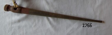
Tool - Fid, 1940s
A Fid is a conical tapered wooden tool used for separating the strands of rope for splicing. They were a tool traditionally made of wood or bone used to work with rope and canvas in marlinespike seamanship. A Fid differs from a marlinspike in material and purposes. A marlinspike is used in working with wire rope, natural and synthetic lines also may be used to open shackles, and is made of metal. A Fid is used to hold open knots and holes in the canvas, and to separate the "lays" (or strands) of synthetic or natural rope for splicing. A variation of the Fid, the grip fid, is used for ply-split braiding. The grip fid has a jamming cleat to pull a cord back through the cord split by the fid's point. Modern Fids are typically made of aluminium, steel, or plastic. In addition to holding rope open to assist the creation of a rope splice, modern push fid's have markings for precise measurements in a variety of sizes of rope. The length of these fid’s is typically 21 or 22 times the diameter of rope to be spliced. Fids have been used since sailing vessels were first used to travel the worlds seas the tool was invented to be used to splice rope and with working with canvas sails. A Fid is a sailors tool that has maintained its general design for hundreds of years and gives a snapshot into what the working life was like for sailors on board sailing ships for hundreds of years. The tool in its original design is still in regular use today by recreational sailors all over the world to splice and join lengths of rope.Metal Fid painted brown, flattened point turned end and hole for a lanyardNoneflagstaff hill, warrnambool, shipwrecked-coast, flagstaff-hill, flagstaff-hill-maritime-museum, maritime-museum, shipwreck-coast, flagstaff-hill-maritime-village, marlinspike -
 Lakes Entrance Historical Society
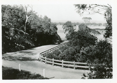
Postcard - Princes Highway Kalimna, 1940c
Plus 3 identical black and white|Plus 2 tinted, (one tinted copy has inscription, 'Jemmy's Point')Black and white small format postcard of the road as it winds around Jemmys Point. It shows a motor car travelling up the hill between the steep cliff of the road cutting and the post and rail guard fence. Glimpse of Bullock Island, lake and hummocks in distance. Lakes Entrance Victoriafences, roads and streets, transport, coast -
 Lakes Entrance Historical Society
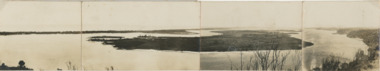
Postcard, Reeves Channel, Rigby Island, the entrance, Bullock Island , Lakes Entrance Victoria, 1920 c
Views of Gippsland Lakes from Jemmy's Point Lakes EntranceBlack and white panoramic folding postcard of the Gippsland Lakes including Reeves Channel, Rigby Island, the entrance, Bullock Island and Lakes Entrance township taken from Jemmys Point Lakes Entrance Victoria. Also panoramic postcard view from southern part of Rigby Island to Lakes Entrance township. And a third postcard "KALIMNA COVE LAKES ENTRANCE"waterways, gippsland lakes -
 Friends of Ballarat Botanical Gardens History Group
Work on paper - Victoria Park, Ballarat, A Brief Chronology 1861-1929, Unknown
A brief though useful chronology of Victoria ParkVictoria Park has featured in the history of Ballarat since 1861.1 page of large print in point form with a bullet for each point.Nonevictoria park, ballarat council, mining companies, arbor day, trees, clegg and nicholls, guilfoyle, f.w.niven, pinus radiata, friends of ballarat botanical gardens, john garner, doctor john garner, john garner collection, gardens, ballarat -
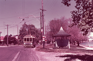 Ballarat Tramway Museum
Slide - 35mm slide/s - set of 2, Noel Simons, Nov. 1970
Set of 2 Kodak Ready-mount with slides made from the Association of Railway Enthusiast Provincial Tramways film strip. 1166.1 - No. 31 at the View Point terminus, corner of Wendouree Parade and Macarthur St., shows tram and section arrangements on poles. Also has SEC tramway shelter alongside stop. Tram has destination of "View Point" 1166.2 - No. 38 crossing Albert St. en route to Sebastopol.1166.1 - "No. 21 at View Point terminus. Line of left is that for cars on "Gardens via Drummond St. Nth" route." 1166.2 - "No. 38 crossing Albert St. near Sebastopol terminus" All have date stamp of "Nov. 1970" in blue ink. Writing in blue ink.tramways, trams, view point, wendouree parade, albert st, sebastopol, tram 21, tram 38 -
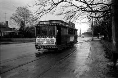 Ballarat Tramway Museum
Photograph - Tram 27 Million Miles - Mal Rowe - 29/6/1968
Photo taken as part of the TMSV tour of the tramway system on a typical Ballarat winters day. Photo in the then disconnected View Point loop in Wendouree Parade. The fence of Ballarat A Power station can be seen in the background. Yields information about the purported achievement of tram 27 reaching 1,000,000 miles and the TMSV Tour. Shows the former View Point crossing loop. This figure was later found to be in error by about 100,000 miles.Digital image of a photograph by Mal Rowe of tram 27 at the former View Point Loop in Wendouree Parade 29/6/1968, during the Tramway Museum Society of Victoria tour to celebrate the tram doing 1,000,000 miles in Ballarat. tmsv, wendouree parade, view point, million miles, tram 27 -
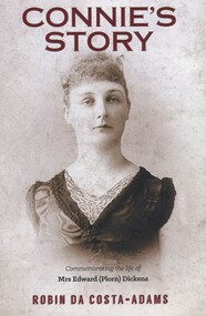 Surrey Hills Historical Society Collection
Book, Connie's Story: Commemorating the life of Mrs Edward (Plorn) Dickens, 2014
Purchased by the Surrey Hills Historical Society for the Surrey Hills Neighbourhood Centre History collection. Includes: illustrations, maps, portraits. Connie Dickens is believed to have spent some of her last year(s) in Surrey Hills. Traces the life of Mrs Edward (Plorn) Dickens, born in 1859 at River-View, Kangaroo Point, Tasmania, the third daughter of Alfred and Emily Desailly (nee Stanfield).Traces the life of Mrs Edward (Plorn) Dickens, born in 1859 at River-View, Kangaroo Point, Tasmania, the third daughter of Alfred and Emily Desailly (nee Stanfield).(mrs) constance emily rose dickens, (mrs) edward (plorn) dickens, (dr) (mr) francis desailly, (mr) alfred desailly, (miss) constance emily rosa desailly, (miss) emily desailly, (miss) florence eva desailly, (mrs) (ann) nancy sophia desailly, box hill cemetery -
 City of Kingston
Pamphlet - Colour, Brock Bros, South Brighton Township Estate, 1888
Sales plan for land in the suburb of South Brighton (Moorabbin), bounded by Point Nepean Road, South Road, Patterson Street and the Mordialloc Railway Line. Incorporates Wolsely Street and Gordon StreetThe developing urban area of Moorabbin within the City of Kingston. This land sale pamphlet illustrates the subdivision of land within the municipality and the changing demographic of the district as new houses are constructed close to infrastructure.Colour pamphlet advertising for private sale the South Brighton Township Estate, South Brighton. Incorporates a map of the estate bordered by Point Nepean Road, South Road, Patterson Street, and the Mordialloc Railway Line. Includes Wolsley Street and Gordon Street. land sales, south brighton, estate, moorabbin -
 Phillip Island and District Historical Society Inc.
Document - Travel ticket
Donated by Isabella NewburyWestern Port Steamers Service Season Ticket. Issued to W D Davie & family to be available from 1st January 19------ to 31 December 19 ------ between Rhyll, Cowes & Stony Point. Issued by A. K. Sambell. Includes PhotographWestern Port Steamer Service / Issued to Mr. W D. Davie. & family / To be available from 1st January, 19... / to 31st December, 19... between Rhyll, / Cowes and Stony Point. / Issued by A. K. Sambellwestern port steamer service, travel ticket, rhyll, cowes, stony point, w.d.davies + family -
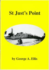 Bendigo Historical Society Inc.
Book - St Just's Point
Author George Ellis is a descendant of the James Family who arrived in St Just's Point in the 1870s. Forward by James Lerk December 2010. Yellow soft cover book. 55 pages. Front cover with black and white photo of house fence and yard in the center. Author George A.Ellis. Contains information, photos, factory drawings, labels relating to the St Just's Point area of Long Gully. Back cover plain yellow. 2010long gully, st justs point, cornish, mining -
 Kew Historical Society Inc
Photograph - Flooding of the Yarra River in North Kew, 1934
North Kew, now divided between Kew and Kew East, bordered the Yarra River. As such, it was a region subject to flooding in the Yarra Valley. Development beyond this point (ie Kellett Grove) was limited by the City of Kew's planning regulations. Prior to urban development, the area since European settlement and the first land sales in the district in the 1840s, had been used for dairy farming. Small sepia snapshot taken from the back yard of a house at 8 Kellett Grove, in what was then known as North Kew. The point of view is from a backyard looking towards Fairfield. Verso: 8 KELLETT GROVEyarra river -- north kew, floods -- yarra valley, floods -- north kew, floods -- 1934, natural disasters -- kew -
 Kew Historical Society Inc
Photograph - Flooding of the Yarra River in North Kew, 1934
North Kew, now divided between Kew and Kew East, bordered the Yarra River. As such, it was a region subject to flooding in the Yarra Valley. Development beyond this point (ie Kellett Grove) was limited by the City of Kew's planning regulations. Prior to urban development, the area since European settlement and the first land sales in the district in the 1840s, had been used for dairy farming. Small sepia snapshot taken from the back yard of a house at 8 Kellett Grove, in what was then known as North Kew. The point of view is from a backyard looking towards Fairfield. Verso: OUR BACKYARD 8 KELLETT GROVEyarra river -- north kew, floods -- yarra valley, floods -- north kew, floods -- 1934, natural disasters -- kew -
University of Melbourne, Burnley Campus Archives
Photograph, James Leslie Provan, Burnley 1942 Album Page 1, 1942
Rock Point.rock point, burnley, 1942, j.l. provan -
University of Melbourne, Burnley Campus Archives
Photograph - Black and white print, Series 3.23, 1942
Series 3Rock Point. rock point, james leslie provan, j.l. provan -
 Port Fairy Historical Society Museum and Archives
Photograph - photograph-mounted, R.W.Golding, 1925
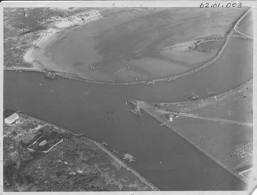
Flight taken in 1925 by Mr R.W.Golding Black and white aerial PhotographMartins's Point Moyne Riveraerial view, martin's point, moyne river, r.w.golding, flight -
Lakes Entrance Historical Society
Postcard - View of Bendigo, J E Barnes Kew, 1920 c
Black and white postcard with decorative edging of a view of Bendigo VictoriaView Point and Fountain Bendigotownship, correspondence -
 Ballarat Tramway Museum
Slide - 35mm slide/s, Wal Jack, 23/01/1961 12:00:00 AM
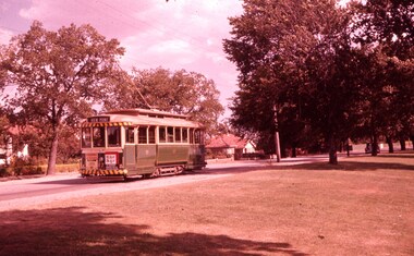
Photo of No. 17 in Wendouree Parade (east side of Lake) showing 'View Point'. Looking across lake foreshore, at rear of tram. Tram not yet fitted with dash canopy lights, but small white stripe has been painted as has the tiger stripes on the bumper and the roof of the tram. Has ads for 'The Age' and 'Bourne Liquid Plastics'. Car number positioned under headlight. Slide going red, Taken on 23-1-61.'SEC Ballarat, No. 17 Wendouree Parade, View Point Line, 23-1-61' in blue ink and 'W.Jack' in purple ink stamp.tramways, trams, view point, wendouree parade, dash canopy lights, tram 17 -
Clunes Museum
Sign
2 SIGNS - CLUNES WRITTEN ON BOARD WITH A HAND POINTING TO THE RIGHT AND ONE POINTING TO THE LEFT.CLUNESlocal history, signs, weickhardt family -
 Woodend RSL
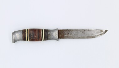
Knife
This knife and scabbard belongs to Lindsay Fankhouser, who wore it on his ankle when he served as an engineer/ crewman in the RAAF (Iroquois and Hercules) during the Vietnam war. He used this knife many times a day while he was serving. The handle of the knife has an aluminium butt that is 18mm long and a bolster that is 19mm long. Between these there are stacked wooden washers. The pattern of the washers is three reddish brown, one white, one black, one white, eleven reddish brown, one white, one black, one white, three reddish brown. The butt has a flat end and a gentle curve downwards (towards sharp side). The handle has a context shape. The bolster has a concave shape. The blade is sharped from 3mm past the bolster. The blunt edge of the knife has a gentle curve inwards from about 55mm along the blade until the sharp point of the blade. There is a maker’s mark on the blunt edge of the knife near the point. It has been worn down and is now illegible.norway, norge, soallingen, knife, small knife, hunting, scabbard, sheath, vietnam, lindsay fankhouser, raaf -
Federation University Historical Collection
Tool - Ethnographic Material, Pirri Points
Six pirri points made out of stone. A pirri point is a small stone point, trimmed on one surface, generally used as a spear tip. It is a leaf shaped point.aboriginal, stone, tool, spear, pirri point -
 City of Kingston
Pamphlet - Colour, J. F. Brady, Matthiesson's Estate, Highett, c. 1905
Sales plan for land in the suburb of Highett, bounded by Tennyson Street, James Street and Point Nepean Road and including Maher Street, Connors Street, Enright Street, Edward Street, James Street and Matthieson Street.The developing urban area of Highett within the City of Kingston. This land sale pamphlet illustrates the subdivision of land within the municipality and the changing demographic of the district as new houses are constructed close to infrastructure.Colour pamphlet advertising for private sale subdivisions in the Matthiesson's Estate, Highett. Incorporates a map of the estate bordered by Tennyson Street, James Street and Point Nepean Road and including Maher Street, Connors Street, Enright Street, Edward Street, James Street and Matthieson Street.Handwritten in blue pencil: x marked on every subdivision on the map Handwritten in grey pencil at the end of the Price List: x not sold Handwritten in grey pencil adjacent to subdivisions 58, 167 and 166: JP. Turner Handwritten in grey pencil adjacent to subdivision 164: [indecipherable] Markings in grey pencil around the edges of the subdivision map Handwritten in grey pencil on reverse: Matthiesson / Matthiesson Estate / Matthiesson Estateland sales, estate, highett -
 Kew Historical Society Inc
Photograph - Flooding of the Yarra River in North Kew, 1934
North Kew, now divided between Kew and Kew East, bordered the Yarra River. As such, it was a region subject to flooding in the Yarra Valley. Development beyond this point (ie Kellett Grove) was limited by the City of Kew's planning regulations. Prior to urban development, the area since European settlement and the first land sales in the district in the 1840s, had been used for dairy farming. Small sepia snapshot of floodwaters taken from near Kellett Grove, in what was then known as North Kew. The point of view is from a backyard looking towards Fairfield. In the foreground ar two men in a rowboat.Verso: OUR BACKYARD / Stamped 3 163yarra river -- north kew, floods -- yarra valley, floods -- north kew, floods -- 1934, natural disasters -- kew -
 City of Ballarat
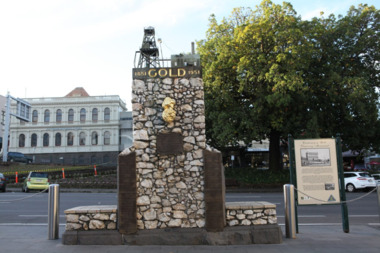
Artwork, other - Public Artwork, The Pioneer Miner's Monument, 1951
The Pioneer Miners’ Monument marks the very first finding of gold at Poverty Point in 1851. The quartz structure features a replica of the 62.8kg Welcome Nugget – the world’s largest at the time, found in Ballarat in 1858. The original was once displayed, and local mothers would sit their babies on top for luck. The artwork tells the story of gold discovery with plaques and dates of some of the more famous gold nuggets finds in Ballarat and is a reminder that these gold discoveries changed the world for Australians. The monument is of aesthetic and historical significance to the people of BallaratFitted copper miniature poppet head set atop a rough made plinth in Quartz and concrete mortar. A copy of the Welcome Nugget (Ballarat) is affixed to the front of the memorial. Includes several plaques listing the nuggets, the companies involved, the shop that paid for the last repair. THIS MONUMENT WAS ERECTED/ BY THE BALLARAT HISTORICAL/ SOCIETY TO COMMEMORATE THE/ FINDING OF GOLD AT POVERTY/ POINT 21ST AUGUST 1851 AND IS/ DEDECATED TO THE MEMORY OF/ PIONEER MINERS OF BALLARATgold, ballaraat, gold rush -
 Running Rabbits Military Museum operated by the Upwey Belgrave RSL Sub Branch
Pencil Drawing
Point of Bravery reproductionequipment, ww2, army -
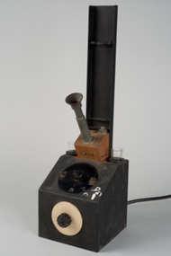 University of Melbourne, School of Chemistry
Melting pot apparatus
Melting Point apparatus