Showing 632 items
matching river st
-
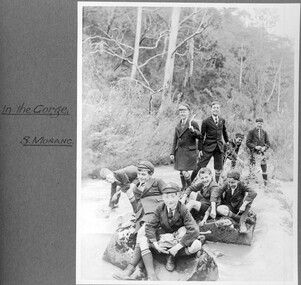 St Patrick's Old Collegians Association (SPOCA)
Photograph - Students, 1920s
-
 City of Kingston
Photograph - Colour, 29 January 1993
Bonbeach is a small beachside suburb located between Chelsea and Carrum. The station was opened in 1926 and was the last to be established in the group from Aspendale to Carrum. Urban growth began after World War II. State primary and high schools were opened in 1958 on land in Breeze Street that was once occupied by The Australian Glass Manufacturers. Immediately east of the school sites is the Patterson River Golf Club. The Bonbeach sports reserve has five ovals and is home to the Bonbeach football and baseball clubs. The suburb borders the Edithvale-Seaford Wetlands which is the remnant site of the Carrum Carrum swamp, once the home of the Bunurong people.Bonbeach was originally a seaside destination for holidaymakers and the housing comprised of holiday homes and gradually more permanent residents. It was not until 1926 that Bonbeach had its own railway station. From 1906 until the late 1940s sand was quarried on the east side of the railway line and used in the manufacture of glass. The Australian Glass Manufacturers sold this land in residential blocks and Bonbeach's permanent population spread from the coastal strip across to the other side of the railway line. Laminated colour aerial photograph of the suburb of Bonbeach and also the southern section of neighbouring Chelsea within the City of Kingston. The extent of this 1993 aerial image includes: Top left - Maury Road at the south end of the Chelsea shopping Centre; Top right - Scotch Parade Chelsea Bottom left - Monica Avenue in Bonbeach; Bottom right - Patterson River Golf Club. Landmarks include St Joseph's Church and Primary School, Chelsea Primary School, Bonbeach Station, Bonbeach Fotball Club sports playing fields and Bonbeach Life Saving Club. The Edithvale Wetlands is featured prominently to the right-hand side of the image. Black typed writing on white adhesive label: No. 6662 Black typed writing on white adhesive label: 26E/6662, 29/1/93, 4.25 pm Black typed writing on white adhesive label: 29-1-93 Black typed writing on white adhesive label: P000109 Circular yellow adhesive sticker bonbeach, chelsea -
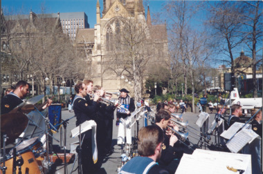 Melbourne Legacy
Photograph, Legacy Appeal 1990, 1990
Photos of Badge Day in Melbourne's City Square (corner of Swanston and Collins Streets) where the Victoria Naval Band is playing on 7 September 1990. There are statues promoting a sporting event in the background (Commonwealth games perhaps). A man in an old Naval uniform is watching and is later on a boat in the Yarra River with President Tony Norris. Part of a Legacy Appeal Week promotion in 1990. Also photos showing a tank in the City Square and a view along Swantson st with Legacy flags on the flag poles. Can see how much the City Square and Swanston St has changed since 1990. Similar to 00491 but there are slight variations so different years. Two of these photos were featured in the 1990 President's Report that was published with the Annual Report, it identifies the man in old Naval costume as Commander Mike Lehan. The article also says: 'On Badge Day, the public of Melbourne responded magnificently to Legacy's call for financial assistance. Our Annual Badge Appeal raised $470,000. given the depressed economy and hard times within the community, Legacy was humbled by the generosity of the community and donations from Bequests totalled $193,966 and a further $111,000 was received from Philanthropic Trusts and Foundations. This year were were overwhelmed by the support of serving members of the Army, Navy and Air Force who assisted Legacy as never before for which we are most grateful.'A record of Legacy being promoted for Legacy Week and being helped by the Armed Services in their fundraising .Colour photo x 16 of Badge Day in the city square with a Navy band.Hand-written on paper label in blue pen 'Badge Appeal - City Activities. 1990 7 Sept. S. Howard'legacy appeal, fundraising, legacy week -
Port Melbourne Historical & Preservation Society
Poster - Map showing ancesttral family estates of Melbourne's first people pre European Settlement, Marcus Lee Design, This once as it was - the ancestral family estates of Melbourne's first people, 2016
This once as it was - the ancestral family estates of Melbourne's first people. Colour map with text. Pre European settlement. Based on Colonial survey maps of Port Phillip Bay region. 1837 and 1864indigenous australians, natural environment, arweet derrmut, point ormond, st kilda, yuro yuroke, bunjil, burrarung river, queensbridge falls -
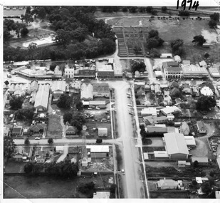 Charlton Golden Grains Museum Inc
Photograph, Aerial photo of Armstrong St, Charlton, c.1974
Aerial photo looking down Armstrong St. Camp street on the left, Shire Hall on the right. High St runs across the photo. The Avoca River is visible in the top LH side. The swimming pool and bowling green is above the rive. On High St (from L-R) Dr Surgery, H Bath Chemist, Grocery, Roy Dobson, Hairdresser, Stowe's, Westpac Bank (two storey white building), Dillon's Building, Globe Hotel, Charlton Club, butcher shop, Arundell's shoe shop, Watson's Stock & Station Agency, Bullock's grocery, Williams St (Curtin Ave), Bannon's Butchers, East Charlton Hotel, MB Luth & Co, Lou's cafe. The old sale yards are at the end of Williams Street. Camp St lower side (from L-R) Court House, Police residence, Police Station, Telecom on corner. The photo is thought to be taken from Ossie Sanderson's airplane in 1974.Black & white aerial photo looking down a broad street that ends in a t-intersection. There is a street that comes off to the left about 1/3 of the way up the photo. There is a large building directly opposite this street. In the upper right there is a two storey building with arches on its verandah. In the upper LH side there is a swimming pool and bowling greens.armstrong st charlton, charlton, business, industry, westpac bank, globe hotel, east charlton hotel, dillon building -
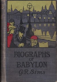 Linton Mechanics Institute and Free Library Collection
Book - Novel, Sims, George R, Biographs of Babylon by George R. Sims, 1902
A collection of stories.Hardcover book with a grey cover. A colour image of three men and a woman along the bank of a river on cover. 240 pages.fictionA collection of stories.george r. sims, fiction -
Linton Mechanics Institute and Free Library Collection
Book - Novel, Page, Gertrude (afterwards Gertrude Dobbin), Follow after!, [1915]
284 p.fictionfiction -
 Linton Mechanics Institute and Free Library Collection
Book - Novel, Curwood, James Oliver, The Golden Snare by James Oliver Curwood, 1918
Hardcover book, 302 pages. Book has a dark red cover with a gold embossed image of a building.fictionjames oliver curwood, fiction -
Linton Mechanics Institute and Free Library Collection
Book - Novel, Lee, Annabel, Star stuff, [n.d.] [1930s?]
Romantic fiction set in the world of film-making. Protagonist, a promising film star, ultimately gives up her career for love.254 p. : plain orange cover, section of original dust jacket pasted to front, depicting a couple sitting by a lake or river, with peacocks(?) in background.Summary of story (also from dust jacket) pasted inside.fictionRomantic fiction set in the world of film-making. Protagonist, a promising film star, ultimately gives up her career for love.annabel lee, fiction, romance -
Linton Mechanics Institute and Free Library Collection
Book - Novel, Rivers, Dorothy, Tangled web, 1946
... Sussex St Linton 3360 Dorothy Rivers Fiction Romance A tale ...A tale of romance and deception.188 p. : green cover, section of original dust jacket pasted to front, image of a woman cupping her face with her hands. Title and author's name hand printed on spine.fictionA tale of romance and deception.dorothy rivers, fiction, romance -
Linton Mechanics Institute and Free Library Collection
Book - Novel, Gerhardi, William, Jazz and Jasper : the story of Adams and Eva, 1928
312 p. : plain red cover, title and author's name embossed in gold on spine.fictionfiction, william gerhardi -
Linton Mechanics Institute and Free Library Collection
Book - Novel, Braddon, M. E. (Mary Elizabeth), Dead love has chains, [n.d.] [1907?]
270 p.fictionfiction -
Linton Mechanics Institute and Free Library Collection
Book - Novel, Peterson, Margaret, Fate and the watcher, [n.d.] [First published 1917? Date of this Hurst & Blackett reprint not known.]
253 p. : embossed red cover. fictionfiction, margaret peterson -
 Victorian Railway History Library
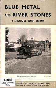
Booklet, The New South Wales Steam Tram & Railway Preservation Society, Blue Metal and River Stones: A Synopsis on Quarry Railways
A brief history of the industrial branch lines around Sydney N.S.W. serving quarries for blue stone and river sand.ill, maps, p.20.non-fictionA brief history of the industrial branch lines around Sydney N.S.W. serving quarries for blue stone and river sand. industrial railroads - australia - history, railroad operations - new south wales - history -
 Victorian Railway History Library
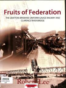
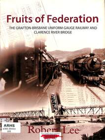
Book, Lee, Robert, Fruits of Federation, 2009
A history of the railway from Grafton to Brisbane and the building of the rail/road bridge over the Clarence River at Grafton.index, ill, maps, p.166.non-fictionA history of the railway from Grafton to Brisbane and the building of the rail/road bridge over the Clarence River at Grafton.railroad construction - new south wales - history, railroad operations - new south wales - history -
 St Kilda Historical Society
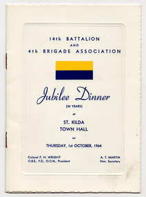
Ephemera - Program, 14th Battalion and 4th Brigade Association Jubilee Dinner, 1964
Program for the dinner to celebrate 50 years of the 14th Battalion at the St Kilda Town Hall on 1 October 1964. Contains a list of the battle honours of the 14th Battalion, the menu, the program, and the words to the song Swanee River.White folded card cover printed in blue with blue and yellow badge of the 14th Battalion, which was originally stapled to an insert of glossy white paper printed on both sides in yellow and blue. The insert is now detached.14th batallion & 4th brigade aif association, 14th battalion aif -
 Victorian Railway History Library
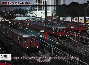
Book, Bow River Publishing, The end of an era : the final years of Sydney's single-deck electric trains, 2007
A photographic tribute to the final years of Sydney's single-deck electric trainsIll, p.80.non-fictionA photographic tribute to the final years of Sydney's single-deck electric trainssuburban railways - sydney, passenger carriages - sydney -
 Victorian Railway History Library
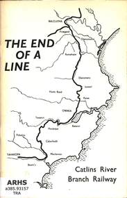
Book, Catlins Historical Society Inc, The End of a Line - Catlins River Branch Railway, 1971
The history of the Catlins River branch railway from Balclutha on the South Island Main Trunk railway New Zealand, to the town of Tahakopa.ill, maps, p.61.non-fictionThe history of the Catlins River branch railway from Balclutha on the South Island Main Trunk railway New Zealand, to the town of Tahakopa.railroads - new zealand - south island - history, railroad construction - new zealand -
 Victorian Railway History Library
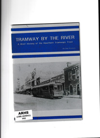
Booklet, Tramway Publications, Tramway by the river : a brief history of the Hawthorn Tramways Trust, 1993
The Hawthorn Tramways Trust was established in 1914, and merged with the Melbourne and Metropolitan Tramways Board in 1920. The Hawthorn line operated via Bridge Road, Richmond. Horse drawn trams were withdrawn in 1916 prior to the introduction of cable trams. The booklet provides technical details about this line, as well as photographs.Ill, maps, p.17.non-fictionThe Hawthorn Tramways Trust was established in 1914, and merged with the Melbourne and Metropolitan Tramways Board in 1920. The Hawthorn line operated via Bridge Road, Richmond. Horse drawn trams were withdrawn in 1916 prior to the introduction of cable trams. The booklet provides technical details about this line, as well as photographs.tramways - melbourne, trams - melbourne - history -
 Victorian Railway History Library
Book, Lee, Robert Stuart, Fruits of Federation, 2009
The story of the railway up to the present. In some ways its use has changed a lot, as freight traffic has replaced passengers as its big earner, traction has changed from steam to diesel, and trains have become bigger, In many ways though, it has not changed enough, remaining inadequate and slow because of its too economical construction.index, ill, maps, p.166.non-fictionThe story of the railway up to the present. In some ways its use has changed a lot, as freight traffic has replaced passengers as its big earner, traction has changed from steam to diesel, and trains have become bigger, In many ways though, it has not changed enough, remaining inadequate and slow because of its too economical construction.railway construction - australia, clarence river bridge (grafton -
 Victorian Railway History Library
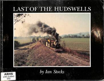
Book, Stocks, Ian, The Last of the Hudswells, 1982
A pictorial tribute to the last ten years of CSR Limited's 2' gauge Hudswell Clark steam locomotives working on the sugar mill railways of the Herbert River Valley around Inghamill, maps, p.98.non-fictionA pictorial tribute to the last ten years of CSR Limited's 2' gauge Hudswell Clark steam locomotives working on the sugar mill railways of the Herbert River Valley around Inghamsteam locomotives - queensland - history, sugar tramways - queensland - history -
 Eltham District Historical Society Inc
Photograph - Digital Photograph, Alan King, Maroondah Aqueduct Siphon Bridge over the Plenty River, 26 January 2008
Opened in 1891, the bridge formed part of the Maroondah Aqueduct carrying water from Watts River near Healesville to the reservoir at Preston where it joined Melbourne's metropolitan water system. Covered under Heritage Overlay, Nillumbik Planning Scheme. Published: Nillumbik Now and Then / Marguerite Marshall 2008; photographs Alan King with Marguerite Marshall.; p99 Built to supply thirsty Melbourne in the late 19th century, the siphon bridge spanning the Plenty River off Leischa Court, Greensborough, was part of an engineering masterpiece. Opened in 1891, the bridge formed part of the Maroondah Aqueduct carrying water from the Watts River near Healesville to the reservoir at Preston where it joined the metropolitan distribution system. A major link in Melbourne’s water supply, it also had a huge impact on communities, which mushroomed along its route. Named after the Aboriginal word for the area around the Maroondah Reservoir, the Maroondah Aqueduct was fully operational until the 1970s. Since the 1980s the land along parts of the aqueduct have been used for walking and bicycle riding, shaded in places by Monterey Pine trees planted to stabilise the surrounding ground. From 1857 the Yan Yean Reservoir supplied Melbourne’s water but the growing city needed additional catchments.1 In 1886 work began on a weir on the Watts River to enable the aqueduct to carry most of the river water 41 miles (66km) to Melbourne. The aqueduct, built by the Board of Works, is the oldest remaining aqueduct near Melbourne and was probably the first built with concrete.2 Although the aqueduct is now only used between the Maroondah and Sugarloaf Reservoirs, it can still be traced across the Shire. It extends from the Maroondah Reservoir through Christmas Hills, Kangaroo Ground, Research, Eltham, St Helena and then previously wound west through Greensborough to Reservoir.3 Built by horse and manpower the aqueduct gravity fed 25 million gallons (113.6ML) of water a day to Melbourne along a gradient of one foot to the mile. It included 25 miles (41km) of open concrete and brick channel, six miles (10km) of tunnels, and nine miles (15km) of 14 inverted siphons of riveted wrought-iron across creeks. Bricks for the aqueduct were made from clay found near the sites and remains of several kilns can still be found between Kangaroo Ground and Christmas Hills. Building the aqueduct transformed local communities. An abattoir was established at Christmas Hills. Grog shanties and labourers’ camps sprang up and local courts dealt with cases of ‘petty pilfering and boisterous behaviour’.4 The Kangaroo Ground school population jumped to 91, crammed into a room with one teacher. Miners who built the tunnels camped just north of Churinga in Greensborough – then called Tunnel Hill Camp – and adjacent to the Evelyn Arms Hotel. The miners’ high spirits were sometimes quenched in horse troughs or by a ‘welt under the ear and kick on the behind’ as the local constable calmed them down rather than lock them up.5 But the growing city of Melbourne needed more water, so the O’Shannassy catchment, east of Warburton, was added to the system in 1914. In 1920 work began on the present concrete Maroondah Dam one mile (1.6km) from the weir on the Watts River. The aqueduct capacity was thus doubled to 50 million gallons (227ML) a day.6 Intense land development threatened to pollute the open water supply, so channel sections were replaced with large pipes. In the late 1960s a large water main was built from the tunnel outlet at Research and extended through St Helena and Greensborough, so this section of the aqueduct was taken out of use. Long sections of the unused open channels in Greensborough and Bundoora were destroyed, but the old channel in Research and Eltham North remained largely intact. In the 1970s, the Sugarloaf Reservoir was constructed, inundating 445 hectares of land in Christmas Hills. Sugarloaf was officially opened in 1980 and serves as a water storage and treatment plant supplying Melbourne. In the early 1980s pipes replaced the section from Sugarloaf Reservoir to the tunnel entrance at Kangaroo Ground. The Research-Kangaroo Ground tunnel operates as part of the pipeline system.This collection of almost 130 photos about places and people within the Shire of Nillumbik, an urban and rural municipality in Melbourne's north, contributes to an understanding of the history of the Shire. Published in 2008 immediately prior to the Black Saturday bushfires of February 7, 2009, it documents sites that were impacted, and in some cases destroyed by the fires. It includes photographs taken especially for the publication, creating a unique time capsule representing the Shire in the early 21st century. It remains the most recent comprehenesive publication devoted to the Shire's history connecting local residents to the past. nillumbik now and then (marshall-king) collection, maroondah aqueduct, pipe bridge, siphon bridge -
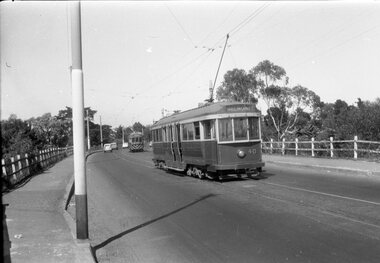 Ballarat Tramway Museum
Negative - Geelong trams 33 & 40 Barwon Bridge, Laurie Gallop, early 1956
Photo shows Geelong trams 33 & 40 in Moorabool St just south of the Barwon Bridge on the long crossing loop. Based on the running board at item 8267, most likely tram No. 33. One of a set of photos was taken between 15/2/1956 and 3/3/1956 when services operated only between Belmont and North before the final closure of the Belmont route on 25/31956 and that bogie tram 31 is not shown on the board, having gone to Ballarat on 15/2/1956 - see item 5554. See item 8213 for an article on the Geelong system by Keith Kings. Yields information about the Geelong operations toward the closure of the tram system.Black and white Negative - 120 sizetramways, geelong, moorabool st, tram 33, tram 40, barwon river -
 Melbourne Tram Museum
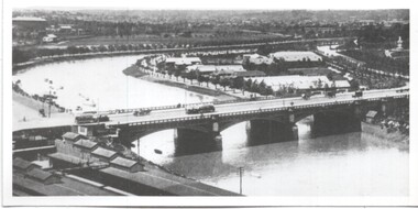
Photograph - Yarra River and Princes Bridge from Flinders St Station clock tower, Town and Country Journal, 1909
... Kilda Road. Yields information about Yarra River, Flinders St ...Photos show the Yarra river looking east over Princes Bridge. In both photos are cable trams, the rowing sheds and parts of Flinders St station. The first phtograph shows the nearly completed ramps from the platform, while the second has the former exit structure that allowed passengers to exit to Princes Bridge and St Kilda Road. Yields information about Yarra River, Flinders St railway station yards and Princes Bridge.Set of two photographs looking east from a Flinders St Station clocktower. over the Yarra River and Princes Bridge..1 – Melbourne Princes Bridge. Copy neg Mark Plummer collections ex late John Alfred collection. Has “T&C 20/12/09” in pencil on rear. .2 – Melbourne – Princes Bridge “Town and Country Journal 29/12/1909” Copy neg Mark Plummer collections ex late John Alfred collection.bridges, flinders st station, yarra river, railways, princes bridge, cable trams -
 Melbourne Tram Museum
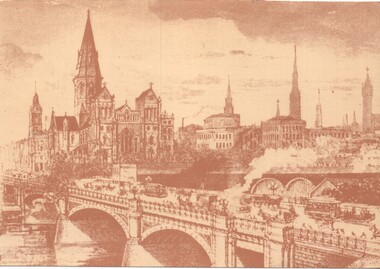
Artwork, other, Princes Bridge from the south bank of the Yarra River, c1900
Sepia toned print of a drawing of Princes Bridge with St Paul's Cathedral and other buildings. Has a number of cable trams and horse drawn vehicles on the bridge. The artist has taken liberties and drawn the spires onto St Paul's cathedral and other buildings such as Princes Bridge railway station. The spires is most likely based on the proposed design at the time. They were built in 1926 to a changed design - see reference.Yields information about the Princes Bridge precinct.Reproduction of a Lithograph drawing - Princes Bridge from the south bank of the Yarra River.melbourne, princes bridge, horse drawn vehicles, st pauls cathedral, cable trams -
Eltham District Historical Society Inc
Document - Folder, Sardi, Jan
Jan Sardi is a screenwriter living in Eltham. Before becoming a screenwriter, he taught at Eltham College for five years. Contents Newspaper article: "Shining star"; Diamond Valley News, 30 November 1996. Jan Sardi won best original screen-play for 'Shine" about David Helfgott, Australian Film Institute awards 1996. Newspaper article: "Oscar nomination"; Diamond Valley News, 19 February 1997. Jan Sardi's film Shine" about David Helfgott is nominated in several categories for Oscars. Newspaper article: "Writer vows to tell dancer's life"; Diamond Valley Leader, 29 November 2006. Jan Sardi plans to tell, in film, the story of Chinese dancer Li Cunxin. Newspaper article: "Eltham is where I like to be - Sardi"; Diamond Valley Leader, 26 May 2010. Jan Sardi to contribute to the Emerging Writers Festival, May 29-30. Newspaper article: "The 'fight goes on' to tell Australian stories", The Age, 11 June 2020. Jan Sardi made an Officer of the Order of Australia.Newspaper clippings, A4 photocopies, etcjan sardi, film "shine", david helfgott, eltham college, st joseph's college north fitzroy, vince colosimo, mao's last dancer, li cunxin, jane scott, film "the notebook", emerging writers festival, film the secret river, mac gudgeon, robert conolly -
Merbein District Historical Society
Slide, Roadscapes, unknown
merbein township, murray river -
Merbein District Historical Society
Photograph, Aerial view Merbein blocks & Murray River flood (framed), unknown
merbein township, murray river -
Merbein District Historical Society
Photograph, Murray River from Merbein Cliffs (framed), c.1912
pump hill, merbein cliffs, murray river, merbein township -
Merbein District Historical Society
Book, Australia's Great River (c 1976 hard cover), 1909-1976
r.m. younger, elwood mead, soldier settlement, csiro, murray river