Showing 111523 items matching "road"
-
 Surrey Hills Historical Society Collection
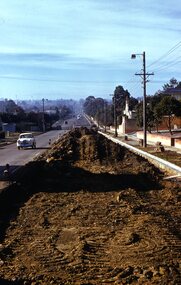
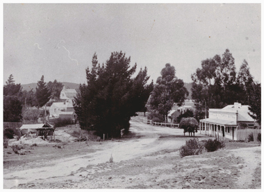
Photograph - Digital photograph, George L Coop, Whitehorse Road Mont Albert during road widening, 1958, c1958
The donor George Lister Coop was about 21 years of age when he took this photo in 1958 as Whitehorse Road was being widened. This was done in sections. It was taken from adjacent to the Coop family home at No.688. The house on the corner of High Street and Whitehorse Road (39 High Street) can be seen in the middle distance. A digital copy of a colour photograph of Whitehorse Road, Mont Albert looking towards Box Hill. The chimneys of Box Hill Gasworks can be seen in the distance. It was taken from adjacent to No 688.george l coop, whitehorse road, box hill gas works, mont albert, 39 high street, road works -
 Vision Australia
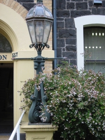
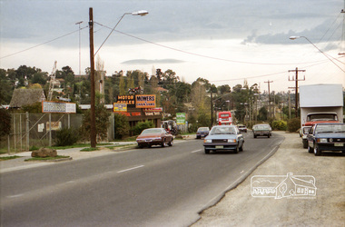
Photograph - Image, Lamp post outside entry to St Kilda Road
Image taken of a lamp outside the reception door of the RVIB St Kilda Road building.1 col. image of lamp outside St Kilda Road buildingroyal victorian institute for the blind, fundraising -
 Eltham District Historical Society Inc
Photograph, Eltham-Yarra Glen Road, Reynolds Road to Kanandah Court
One of a set of display images thought to be produced by the Shire of Eltham c.1979-1987Illustrative of services provided by former Shire of ElthamColour photograph 20 x 29 cm mounted on green-painted chipboard 28 x 35.5 cm (string on back for hanging)Title printed on label adhered to board below photograph (replaced June 2017)road, eltham-yarra glen road, eltham -
 Surrey Hills Historical Society Collection
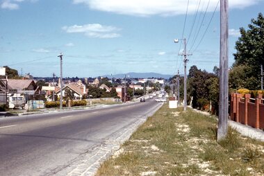
Photograph - Digital photograph, George L Coop, Whitehorse Road Mont Albert prior to widening, 1958, c1958
The donor George Lister Coop was about 21 years of age when he took this photo in 1958 before Whitehorse Road was widened. It was taken from adjacent to the Coop family home at No.688. Greythorn Caravans factory / showroom / yard was established c1953 at 731 Whitehorse Road. F R Horwood Wrought Iron at 733 Whitehorse Road was established in the 1940s.A digital copy of a colour photograph of Whitehorse Road, Mont Albert looking towards Box Hill. The Box Hill Gasworks can be seen in the middle distance. A caravan retailer can just be seen in the foreground on the northern side of Whitehorse Road.george l coop, whitehorse road, box hill gas works, mont albert, greythorn caravans, f r horwood wrought iron -
 Eltham District Historical Society Inc
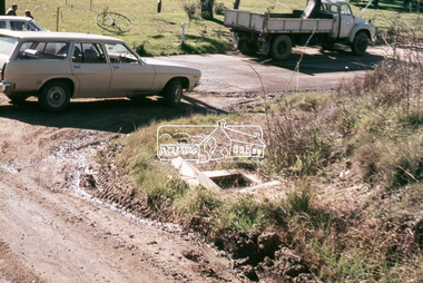
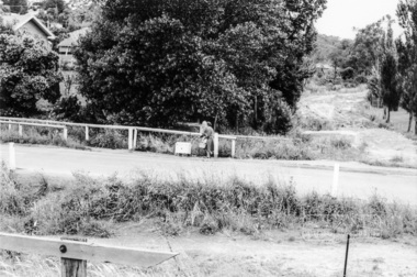
Slide, In Bonds Road south of the northern arm of Montpelier Drive, Lower Plenty, 18 July 1972, 1972
Water drainage work undertaken by Eltham Shire Council in Bonds Road, Lower Plenty outside the Martin property opposite Montpelier Drive, July 1972 Note the blocked pit full of water and water circumnavigating the pit.35 mm colour positive transparency Mount - Agfacolor Service (Blue)Bonds Road (Martin property) 12.10 pm 18.7.72bonds road, drainage works, eltham shire council, infrastructure, lower plenty, martin property, montpelier drive -
 Eltham District Historical Society Inc
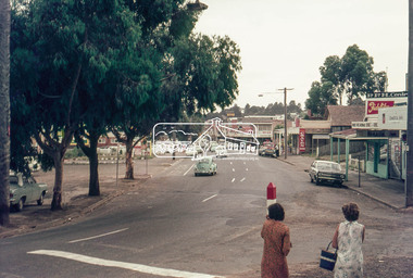
Photograph, Looking north along Main Road at Dudley Street, Eltham, c.February 1968, 1968
Immediately prior to duplication of Main Road35mm Colour positive transparency Mount - Agfacolor Service (Blue stepped)arthur street, dudley street, duplication, eltham, main road, shopping centre -
 Eltham District Historical Society Inc
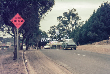
Photograph, Main Road, Eltham near Dudley Street, c.February 1968, 1968
Immediately prior to duplication of Main Road35mm Colour positive transparency Mount - Agfacolor Service (Blue stepped)bp service station, duplication, eltham, main road -
 Kiewa Valley Historical Society
Photograph of Kiewa Valley Panorama, Kiewa Valley from No. 5 Road, Before 1945
In 1943 a camp for workmen was erected and a commencement made with the erection of plant storage and workshop buildings in the new township of Mt. Beauty. The photograph was probably taken after the completion of these buildings. There is no sign of construction of the town itself. In the latter part of 1945 work was commenced on the Mt. Beauty township area with a medical centre, general trading store and some houses under construction. The No. 5 Road, from where the photograph was taken, is the road to West Kiewa Power Station and Big Hill Scenic Lookout.Is an excellent view of the Kiewa Valley before there was little work undertaken to establish the town of Mt. Beauty. Farming was well established with the evidence of huge areas of cleared land. The junction of the East and West Kiewa Rivers can be clearly seen. The first Workmen's camp is near the river and some workshop buildings can also be seen. Black and white photograph of the Kiewa Valley, looking North.Handwritten on the back of photograph "Kiewa Valley from No. 5 Road".kiewa valley, camp, buildings, mt. beauty -
 Whitehorse Historical Society Inc.
Newspaper - Article, 5 Longland Road, Heatherdale, 22/02/1984
Article in Nunawading Gazette re sale of 100 year old home at 5 Longland Road, Heatherdale. Double brick Victorian on bluestone foundations. Originally land was owned by Mr Witt who later became an M.P., later a master butcher. Mr Purches built the bluestone foundations. It was planned to have a village nearby to be called New Brunswick between Emery's Hill (now Mitcham) and what is now Ringwood. The only evidence of the once planned village is the existence of Brunswick Road nearby.longland road, mitcham, witt, william, purches (mr), brunswick road, mitcham, heatherdale, mitcham, emery's hill, real estate, auctions -
 Eltham District Historical Society Inc
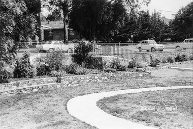
Photograph, War Memorial Garden, Main Road, Eltham, February 1968, Feb 1968
Shows the ramp leading into the gardens from Main Road which lead to the Children's Library and Pre-school buildings. Shows part of the Catholic School buildings across Main Road at Dudley Street intersection.In February 1968 an unknown person took a series of photos from the Eltham Hotel at Pitt Street heading north along Main Road through the shopping centre to just north of Elsa Court covering the length of the section of Main Road which was duplicated shortly thereafter. Shows the condition and environment of the streesscape of Main Road, Eltham immediately prior to the duplication between Pitt Street and Elsa Court through the shopping centre. Also shows a number of shops and businesses that operated at that time.Black and white photographduplication, eltham, main road, shire of eltham war memorial, pre-school, children's library, our ladys church -
 Linton and District Historical Society Inc
Photograph, Murrell's Victoria Hotel and Edinburgh Mine, Skipton Road, Linton
Two copies - original sepia photograph, and restored black and white copy, showing road coming in to Linton from Skipton, Murrell's Hotel on RHS, Edinburgh Mine works on LHS. Also mounted photograph.On back of original photograph: "Esther Cluff".linton township, murrell's victoria hotel, edinburgh mine -
Marysville & District Historical Society
Document (Item) - Newspaper article, The Argus, New Tourist Road. Marysville to Wood's Point Magnificent Forest Scenery, 02-1924
A newspaper article regarding the opening of the Marysville-Wood's Point Road in February 1924.A newspaper article regarding the opening of the Marysville-Wood's Point Road in February 1924. The Marysville-Woods Point Road was originally part of the Yarra Track, constructed in the early 1860s to provide access between Healesville and the Woods Point Goldfields. Despite the steep terrain and engineering difficulties, the Yarra Track soon became a busy route used by pack horses, horse-drawn drays, and wagons. Today this sealed mountain road is a popular scenic drive between Marysville and Warburton.marysville-wood's point road, yarra track, healesville, wood's point goldfields, warburton, the argus -
 Eltham District Historical Society Inc
Photograph, Looking east across Main Road from just north of intersection with Diamond Street, Eltham, February 1968, Feb 1968
The watercourse passes under the road and railway at this point. Significant flash flooding occurred along this water course on Christmas Day 2011 causing significant damage to the railway line and road and flooding of Judge Book Village. In February 1968 an unknown person took a series of photos from the Eltham Hotel at Pitt Street heading north along Main Road through the shopping centre to just north of Elsa Court covering the length of the section of Main Road which was duplicated shortly thereafter. Shows the condition and environment of the streesscape of Main Road, Eltham immediately prior to the duplication between Pitt Street and Elsa Court through the shopping centre. Also shows a number of shops and businesses that operated at that time.Black and white photographduplication, eltham, main road, diamond street, bible street reserve, watercourse, drainage -
 Greensborough Historical Society
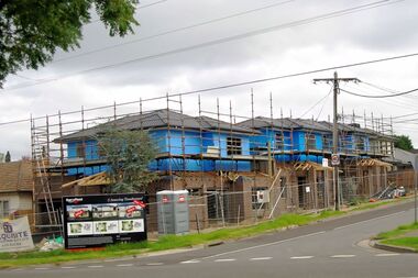
Photograph - Digital image, Marilyn Smith, Watsonia Road unit development , 2016, 24/05/2016
Unit development in Watsonia Road, Watsonia 2016.Digital copy of colour photograph.watsonia, watsonia road -
 Greensborough Historical Society
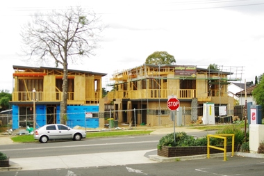
Photograph - Digital image, Marilyn Smith, Watsonia Road unit development , 2016, 24/05/2016
Unit development in Watsonia Road, Watsonia 2016.Digital copy of colour photograph.watsonia, watsonia road -
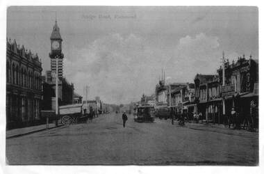 Melbourne Tram Museum
Photograph - Enlargement of a postcard, Bridge Road Richmond, c1900
The first image shows the shops on either side of Bridge Road with horse drawn carts and one cable tram. The second image from the Town Hall tower, shows two cable tram sets, the narrowing of the road. Has in the view Guddon & Selleck Auction House and Property Exchange also advertising Commercial Union Assurance Co. and George Stirling and Sons store.Yields information about Bridge Road, c1900Set of two A3 enlargements of postcards 1 - Looking east along Bridge Road from near Church St 2 - Bridge Road Richmond - from Town Hall looking westcable trams, tramways, richmond, bridge road, -
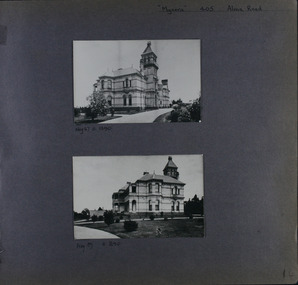 Glen Eira Historical Society
Album - Album page, Myoora, 405 Alma Road, Circa 1972
This photograph is part of the Caulfield Historical Album 1972. This album was created in approximately 1972 as part of a project by the Caulfield Historical Society to assist in identifying buildings worthy of preservation. The album is related to a Survey the Caulfield Historical Society developed in collaboration with the National Trust of Australia (Victoria) and Caulfield City Council to identify historic buildings within the City of Caulfield that warranted the protection of a National Trust Classification. Principal photographer thought to be Trevor Hart, member of Caulfield Historical Society. Most photographs were taken between 1966-1972 with a small number of photographs being older and from unknown sources. All photographs are black and white except where stated, with 386 photographs over 198 pages.Victorian Heritage Register (VHR) Number H0490 From the Victorian Heritage Register Database - Citation for Myoora https://vhd.heritagecouncil.vic.gov.au/places/275 (as at 6/10/2020) Myoora, 405 Alma Road, North Caulfield, was designed by Reed, Henderson & Smart and can be attributed to Anketell Henderson. It was built in 1886 and 1887 for Thomas Christian, who had founded the fabled gold mine, the Day Dawn at Charters Towers. He never occupied the house although his widow lived there for some time. The house was subdivided into three and later six flats. Myoora was one of many large mansions on broad acres with gardens in Caulfield. Perhaps the grandest was Labassa. The mansions date from the 1850s through to the late 1890s. The siting of Myoora on a ridge influenced its planning and composition. A central hall and corridor along the ridge is entered from the centre of the more formal north facade. The entrance is marked by an elaborately detailed tower. A stair turret provides a second accent. The western end of the building is completed by a massively detailed chimney as the service wing. The south facade enjoyed an outlook to port phillip from a two-storey cast iron verandah. Bay windows, chimneys, the tower and the turret and minor details are brought together in a sophisticated asymmetrical composition. This is reflected in the planning. The asymmetry of Myoora pivoting on the tower is the most notable feature of the building. The walls are built of cement rendered brick. The cement render has not been painted. The roof is slate. The balconies and verandah are cast iron. The footings and cellar are bluestone. The architectural firm Reed, Henderson & Smart was very prominent in Victoria in the nineteenth century. Anketell Henderson was an eminent and well respected member of the profession. He worked successfully in London and interstate as well as in Victoria. They were better known for commercial and public buildings. Myoora is an important private commission. The style of Myoora is a combination of details from the Continental and English Renaissance through the boom style and the Queen Anne style. There is also an early influence from the American Romanesque style especially in the stair turret. The latter style was important at the turn of the century and Myoora is a significant precursor. Other buildings of a similar scale survive in Caulfield and elsewhere. Labassa, the most fabulous, is quite different stylistically as are most of the other comparable mansions. Stonnington is perhaps closer but relies on different details from the Queen Anne style and lacks any American influence. For its historical associations through its owners and architects, for its style and composition and for its intactness, Myoora is significant at a State level. The craftmanship of Myoora is what could be expected of a building of the time and type. It is relatively intact and in fair condition. The main staircase has been removed, minor alterations to decorative features have occurred and additions have been made to the exterior.Page 14 of Photograph Album including two black and white photographs that are arranged in landscape orientation in the centre of the page with one beneath the other. Handwritten: "Myoora" 405 Alma Road [top right] /Neg 87 c1890 [under top photo]/ Neg 89 c1890/ [under bottom photo]/ 14 [bottom right]caulfield north, trevor hart, alma road, mansion, myoora, tower, thomas christian, 1880's, queen anne, cement rendered brick, unpainted, balconies, verandahs, anketell henderson, continental and english renaissance, american romanesque, cast iron balconies, gardens, views, cast iron work, reed henderson & smart, flats, asymmetrical style, slate roofs -
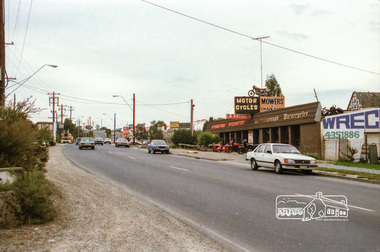
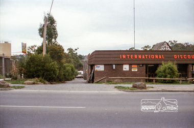
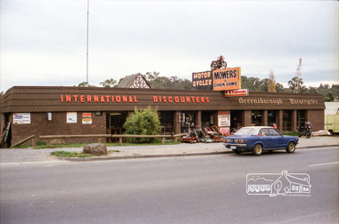
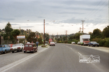
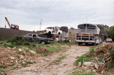
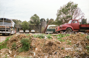
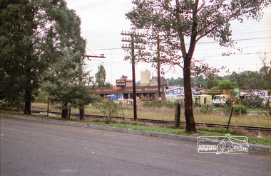
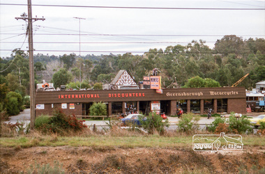
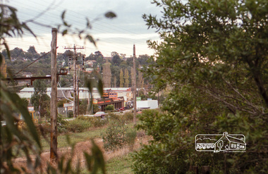
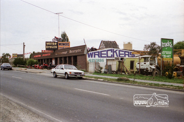 Eltham District Historical Society Inc
Photograph, Industrial development, Para Road, Briar Hill, c.1984, 1996
Views of industrial sites and shop fronts on Para Road, Briar Hill including the business 'Greensborough Motorcycles'. Para Road, Briar Hill is parallel to the Hurstbridge Railway Line. The building 'Greensborough Motorcycles' was destroyed by fire in the early 2000s.Roll of 35mm colour negative film, 4 stripsKodak CP 100 5094briar hill, greensborough, greensborough motorcycles, hutchinson's, industry, international discounters, para road -
 Eltham District Historical Society Inc
Negative - Photograph, Industrial development, Para Road, Briar Hill, c.1984
Views of industrial sites and shop fronts on Para Road, Briar Hill including the business 'Greensborough Motorcycles'. Para Road, Briar Hill is parallel to the Hurstbridge Railway Line. The building 'Greensborough Motorcycles' was destroyed by fire in the early 2000s.Roll of 35mm colour negative film, 4 stripsKodak CP 100 5094briar hill, greensborough, greensborough motorcycles, hutchinson's, industry, international discounters, para road, business -
 Eltham District Historical Society Inc
Photograph, Industrial development, Para Road, Briar Hill, c.1984, 1996
Views of industrial sites and shop fronts on Para Road, Briar Hill including the business 'Greensborough Motorcycles'. Para Road, Briar Hill is parallel to the Hurstbridge Railway Line. The building 'Greensborough Motorcycles' was destroyed by fire in the early 2000s.Roll of 35mm colour negative film, 4 stripsKodak CP 100 5094briar hill, greensborough, greensborough motorcycles, hutchinson's, industry, international discounters, para road -
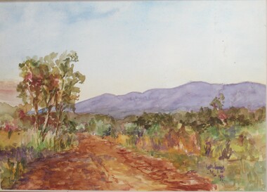 Ringwood and District Historical Society
Painting, Winifred Miles, "Mullum Road" (Ringwood) - Water colour on paper by Winifred Miles (1884-1944), Undated, later than 1910
"Alexander Colquhoun [Herald art critic 1914-1922 and feature writer for the Age 1926-1941] ... took private students in the first decade of the century, and one of these was Winifred Miles, who after her marriage in 1910 lived the remainder of her life in Ringwood. ... (She) began by doing charcoal studies of animals when she was in Balranald, but in later years moved to oils and then watercolours, travelling around Ringwood to find places to paint by means of a pony-driven governess-cart. She won prizes for paintings in the Royal Melbourne Shows." - Hugh Anderson - Ringwood, Place of Many Eagles [p.217].Painting with cardboard border in glass-fronted frame. One of two undated paintings by Winifred Miles' viewed from the same vantage point on Mullum Mullum Road in Ringwood. (See Registration Number 4848)Sticker on back of frame - "Ringwood Framing Gallery, 233 Whitehorse Road Ringwood, Phone 8704930" -
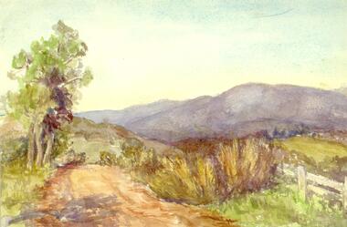 Ringwood and District Historical Society
Painting, Winifred Miles, "Mullum Road" (Ringwood) - Water colour on paper by Winifred Miles (1884-1944), Undated, later than 1910
"Alexander Colquhoun [Herald art critic 1914-1922 and feature writer for the Age 1926-1941] ... took private students in the first decade of the century, and one of these was Winifred Miles, who after her marriage in 1910 lived the remainder of her life in Ringwood. ... (She) began by doing charcoal studies of animals when she was in Balranald, but in later years moved to oils and then watercolours, travelling around Ringwood to find places to paint by means of a pony-driven governess-cart. She won prizes for paintings in the Royal Melbourne Shows." - Hugh Anderson - Ringwood, Place of Many Eagles [p.217].Painting with cardboard border in glass-fronted frame. One of two undated paintings by Winifred Miles' viewed from the same vantage point on Mullum Mullum Road in Ringwood. (See Registration Number 4847)Sticker on back of frame - "Ringwood Framing Gallery, 233 Whitehorse Road Ringwood, Phone 8704930"