Showing 3851 items
matching track
-
 Marysville & District Historical Society
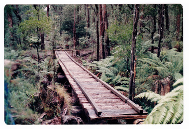
Photograph (item) - Colour photograph, Doug Orford, Unknown
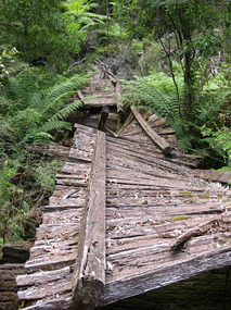
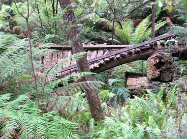
A colour photograph of the timber tramway bridge along the Michaeldene Walking Track near Marysville in Victoria.A colour photograph of the timber tramway bridge along the Michaeldene Walking Track near Marysville in Victoria. The Michaeldene Trail to Taggerty River Lookout is a 4.3 kilometer lightly trafficked loop trail located near Marysville, Victoria. The track is one of several walking tracks located in and around Marysville in Victoria.Doug ORFORDtimber tramway, michaeldene walking track, marysville, victoria, walking track -
 Ballarat Tramway Museum
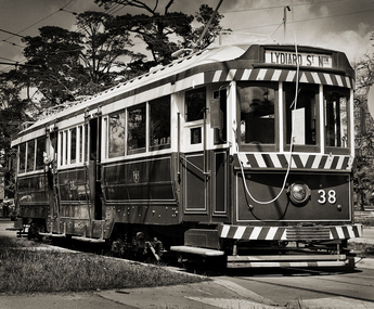
Photograph - Ballarat 38 - BTM, Greg Naylor, 2022
Black and White photo of Ballarat 38 - BTM on depot access track. See reference for the history of this tram. Photographed during 2022 on a Mamiya RB67 large format film camera.Yields information about BTM tram 38.Black and White photo of Ballarat 38 - BTM on depot access track.btm, trams, tramcars, tram 38 -
 Whitehorse Historical Society Inc.
Document, Dorothy Maxwell, 9/05/2005 12:00:00 AM
Interview of Dorothy Maxwell by Valda Arrowsmith.Interview of Dorothy Maxwell by Valda Arrowsmith, about the establishment of the Bill Sewart Athletics Track and the Little Athletics movement.Interview of Dorothy Maxwell by Valda Arrowsmith.bill sewart athletic track, nunawading little athletics club -
 Falls Creek Historical Society
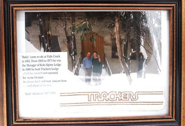
Photograph - "Baldy" Blackwell and Trackers
This photo is from the private collection of George Shirling of Red Onion, Falls Creek. George Shirling arrived in Falls Creek in 1962. He engaged Phil Nowell to build the original Koki Alpine Lodge which opened in 1965 with 14 beds. George operated the lodge with Michael “Baldy” Blackwell as manager. He also graduated in sport psychology in 1981 and was invited to become team psychologist for the Australian Winter Olympic team which went to Albertville, France, in 1992. He later owned the Red Onion Chalet. George credited the success of Koki to “Baldy” Blackwell. “Baldy” and Phil Nowell started the Trackers Mountain Lodge in partnership during the 1980s. In 1971 George sold Koki Lodge to Sigi Doerr. In 2024 the renamed Koki Alpine resort remains a highly popular destination in Falls Creek. George Shirling passed away on 27th February 2023. He had remained actively involved in Falls Creek and was generous with his time and knowledge, always an amazing supporter of The Falls Creek Museum and Falls Creek Village.This photo is significant because it features "Baldy" Blackwell of Trackers Mountain Lodge, Falls Creek, Victoria.A framed photograph of "Baldy" Blackwell standing outside the front of "Trackers". A fabric souvenir patch and a label have been included in the frame.On Label 'Baldy 'came to ski at Falls Creek in 1962. From 1965 to 1971 he was the Manager of Koki Alpine Lodge. In 1980 he built Trackers Lodge which he owned and operated for some 14 years. An always kind and ever sincere host ....well ahead of his time. "Baldy Blackwell" 1937-1995george shirling, "baldy" blackwell, trackers lodge -
 Melbourne Tram Museum
Photograph - Black & White Photograph/s, 2009
Set of two Photographs printed on A4 sheet, photocopy - of the rail tram level crossing at Glenferrie Road, Kooyong showing the rubber inserts and the level crossing - taken from the cab of a train in either direction. Shows the level crossing, platform and track, along with part of the signal box and boom barriers.1 - "Looking away down track from Melbourne - Glenferrie Rd Kooyong Station - 2009" 2 - "Looking towards Melbourne up track - Glenferrie Rd Kooyong Station - 2009"trams, tramways, kooyong, level crossings, glenferrie road, tramway square, railway squares -
 Sunbury Family History and Heritage Society Inc.
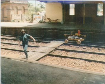
Photograph, c 1970
A railway maintenance person is crossing the railway tracks from Platform 2 to Platform 1 at Sunbury Station. There is a partial view of the historic brick water tower, which was used by the steam engines, on Platform 2.A coloured photograph of a maintenance man walking across a railway track at a station.sunbury railway station, water towers -
Marysville & District Historical Society
Document (item) - Research Document, Judith Vimpani, Hermit of the Cumberland Goldfield-George Ernest Locke, 2020
An account of the life of George Ernest Locke who was a gold miner on the Yarra Track near Marysville in Victoria.An account of the life of George Ernest Locke who was a gold miner on the Yarra Track near Marysville in Victoria. George was a well-educated young man and had some success prospecting in the Cumberland area before partnering with William Chester with whom he opened the Golden Bower gold mine in 1896. George and William then discovered a second reef which they named the Silver Bower mine. George lived in a log cabin in the Cumberland reserve and was known to be a loner. He was clever with his money and chose not to have a bank account in Marysville, where everyone would learn about his financial status. He banked at the ES&A in Fitzroy and at the time of his death in 1941 he had accumulated the princely sum of three hundred and sixty pounds. George Locke was known as "the Hermit of Cumberland Valley" and lived in his humpy until his last few days during which he moved into a Forest Commission's patrol hut because his old humpy had started to fall to pieces. When George passed away at the age of 81 years he had not visited Marysville for over 14 years. george ernest locke, gold miner, gold mining, yarra track, william chester, golden bower mine, cumberland goldfield, silver bower mine, chesterville, marysville, victoria, jackie lewis, baron somers, big tree, picea sitchensis exotic, box hill cemetery, john edward locke, annie caroline locke, hermit of the cumberland valley -
Whitehorse Historical Society Inc.
Map, Shires of Boroondara, Nunawading, C1856
Photocopy of part of very early map covering parts of Boroondara and Nunawading.Photocopy of part of very early map covering parts of Boroondara and Nunawading. Marks old tracks on lines of Whitehorse and Canterbury Roads.Photocopy of part of very early map covering parts of Boroondara and Nunawading.maps, shire of nunawading, shire of boroondara, barkers track, deep creek, nunawading -
 Melbourne Tram Museum
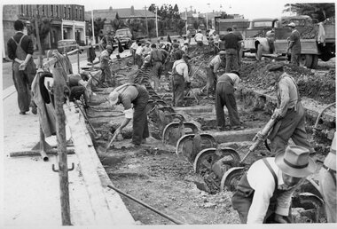
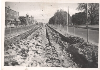
Photograph - Black and White - demolishing cable tram track Smith St and Queens Parade 1954/55
The photograph shows the demolition or removal of the cable tram track at the intersection of Smith St Gertrude St. Fitzroy. The workmen are excavating the former cable tram track The inbound cable tram track remains in position. The 1955 Annual Report notes that work commenced following the completion of the Queen's visit in March 1954 and that all work was done by day-labour. The track was opened to service in late June 1955. The second image is from a Melbourne and Metropolitan Board of Works plan (part) No. 1217 - Collingwood for the intersection, obtained for reference from the State Library of Victoria Collection of MMBW Plans. It shows the layout of the cables and the large sheave pit that the cable itself passed around. The trams were required to drop the cable from the grip prior to the entry to the curve and then coast around. Photographer is possibly Keith Kings.Yields information about the extent of work need to convert the former Northcote Cable tram route to Electric trams, the people and the methods used to undertake the work.Photograph - Black and White of the demolition of the cable tram track at the corner of Queens Parade - Smith St Clifton Hill.trams, tramways, cable trams, workmen, mmtb, demolition, track work, conversion, smith street, queens parade, clifton hill -
 Melbourne Tram Museum
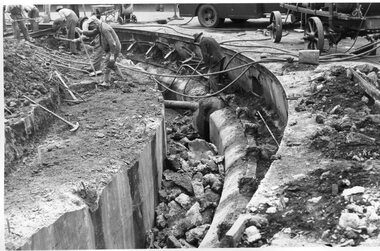
Photograph - Black and White - demolishing cable tram track Smith and Gertrude Streets 1954/55
The photograph shows the demolition or removal of the cable tram track at the intersection of Smith Street and Gertrude St Fitzroy, 1954/55. Photo shows the workmen excavating and demolishing parts of the massive infrastructure needed at this curve to enable cable trams to pass around the sharp curve, still one of the sharpest on today's Melbourne tram system. The outside cable tram track remains in position. The MMBW plan shows a large cable sheave pit on the outside of the curve. The 1955 Annual Report notes that work commenced following the completion of the Queen's visit in March 1954 and that all work was done by day-labour. The track was opened to service in late June 1955. Photographer is possibly Keith Kings.Yields information about the extent of work need to convert the former Northcote Cable tram route to Electric trams, the people, the extent of the original construction and the methods used to undertake the work.Photograph - Black and White - demolishing cable tram track Smith and Gertrude Streets 1954/55trams, tramways, cable trams, workmen, mmtb, demolition, track work, conversion, smith street, gertrude street, fitzroy -
 Melbourne Tram Museum
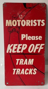
Sign - "Motorists Please Keep Off Tram Tracks"
Used by the MMTB in an attempt to keep tram tracks clear of motor cars. It seldom worked. Signs would have been fixed to the ends of a tram so it could be seen by motorists. See Item 6088 for another version.Demonstrates the methods the MMTB to ask motorists to keep tram tracks clear during the 1950's and 1960's.Sign - Zincalume steel sheet, with four holes in angled or trimmed corners asking "Motorists Please Keep Off Tram Tracks" Has the image of a motor car on the tram tracks with the outline of a tram following.tram stop, signs, mmtb, traffic control, trams, tramways -
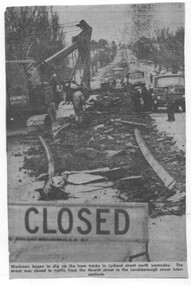 Ballarat Tramway Museum
Newspaper - Cutting - track removal Ballarat 1972, The Courier Ballarat
The newspaper cutting shows the nature of the track removal in Lydiard St North, Ballarat following closure of the SEC operated tramway system. Cutting not dated. Date based on an Tender advert on the rear, July 1972.Demonstrates the method of track removal, most likely by the Country Roads Board July 1972 Cutting from The Courier, Ballarat.Newspaper cutting - Cutting - track removal Ballarat 1972, Lydiard St North. track removal, lydiard st north, ballarat, tramways -
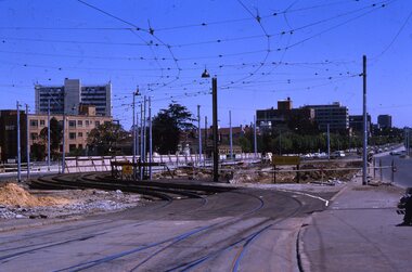 Melbourne Tram Museum
Slide - Set of 2, Keith Kings, 24/12/1967 12:00:00 AM
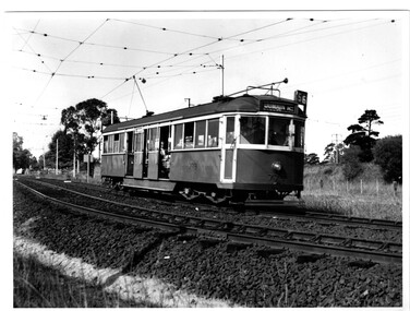
Set of two 35mm Kodak white cardboard colour slide by Keith Kings of 24/12/1967 - .1 - St Kilda Junction, looking north along St Kilda Road, showing the nature of the diversion from the junction for Wellington St. .2 - Dandenong Road, showing the track diversion work for Dandenong Road/Queensway, Windsor.Keith Kings stamp and number "15-1" and "15-5"", with details of exposure. .1 - SW6 car on temporary track at St Kilda Junction looking north from turnout during freeway work .2 - Dandenong Road west from Hornsby St with section of straight track ready to replace curves onto new b.v.w. track to Chapel St - 907 coming off soon to be abandoned street track.trams, tramways, st kilda junction, trackwork, road works, dandenong road, queensway, tram 907 -
 Marysville & District Historical Society
Photograph (item) - Colour photograph, 31-12-2008
A digital copy of a colour photograph of the timber tramway bridge along the Michaeldene Walking Track near Marysville in Victoria.A digital copy of a colour photograph of the timber tramway bridge along the Michaeldene Walking Track near Marysville in Victoria. The Michaeldene Trail to Taggerty River Lookout is a 4.3 kilometer lightly trafficked loop trail located near Marysville, Victoria. The track is one of several walking tracks located in and around Marysville in Victoria.timber tramway, michaeldene walking track, marysville, victoria, walking track -
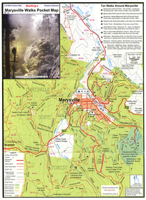 Marysville & District Historical Society
Map (Item) - Pocket map, Rooftop Mapping Services, Rooftop's Marysville Walks Pocket Map, 01-2009
A pocket map of ten walking tracks in an around Marysville. This map was published by Rooftop Mapping Services in January 2009.A pocket map of ten walking tracks in an around Marysville.marysville, victoria, australia, rooftop mapping services, steavenson falls, steavenson falls car park walk, beauty spot walk, marysville to el kanah guest house walk, gilberts gully walk, michaeldene track, man 'o' war walk, tree fern gully walk, marysville to woods lookout to mount gordon walk, keppels lookout walk -
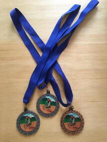 Geelong Cycling Club
Medals, 2002
Medals were presented by the Geelong West Cycling Club until the year 2002.Medals have always been given as recognition of achievement in competitive events.Medals in bronze and silver metal conglomerate. The front depicts an olive wreath around the circumference, and has a racing cyclist painted on an enamel disk in the centre. On the reverse side, inscription of the winner of the Women's Track Championships for 2002 appears inside an olive wreath decoration. "GWCC/Track Championships/Scratch Race/Women/Yolanda Russell/2002/Sprints/Time Trial"gwcc; track championships; scratch race; women; yolanda russell; 2002; sprints; time trial; -
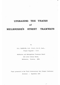 Melbourne Tram Museum
Document - Report, Bob Vanselow, "Upgrading the tracks of Melbourne's Street Tramways", 1979
Report - comb bound 63 pages + appendices 30 pages - titled "Upgrading the tracks of Melbourne's Street Tramways", written by Bob Vanselow, MMTB Project Engineer and presented to the Third International Rail Sleeper Conference Brisbane September 1979. The paper looks at the then current system, historical track methods, current track laying methods and parameters, special work, crossings, joints, concrete mixes, design, open ballast track. The appendices has various diagrams and photographs showing track construction details. Hard copy added 29/3/2020 - received and printed in an e-mail dated 28/4/2011, from Bob Vanselow - See Reg Item 4431 for details.trams, tramways, track, mmtb, track laying, construction, sleepers, rails, points -
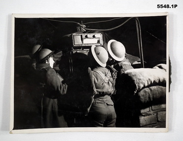 Bendigo Military Museum
Photograph
All photos of female British Army soldiers manning Air Defence Stations protecting Air Field from enemy attack using range finding equipment and predictors tracking incoming aircraft. Related to Beryl Scrimshaw (Morrel) of British Army. refer Cat No.304P & 315. All black and white photos of female British soldiers manning Air Defence Units. 1. Soldiers using prediction at night to track aircraft. 2. Soldiers in British Uniform at night using range finder to track aircraft. 3. Soldiers in British Uniform at night using range finder to track aircraft.On back - stamp of "Manchester Guardian & Evening News" Photo 1 also has description "Predictor". Photo 2 has description "Aircraft Spotter".aircraft defence, female soldiers, british army -
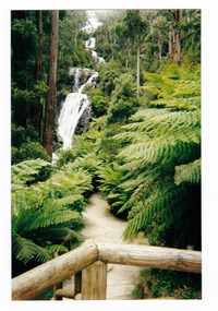
 Marysville & District Historical Society
Photograph (item) - Colour photograph, Pre 2009
A colour photograph of the walking track leading to Steavenson Falls in Marysville in Victoria.A colour photograph of the walking track leading to Steavenson Falls in Marysville in Victoria. The Steavenson Falls is named after the Victorian Assistant Commissioner of Roads and Bridges, John Steavenson who arrived in Victoria in the early 1860s.Munroesteavenson falls, waterfalls, marysville, victoria, john steavenson -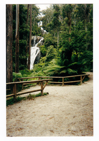
 Marysville & District Historical Society
Photograph (Item) - Black and white photograph, The "Scandinavians' - (Deserted), c1900
An early black and white photograph of The Scandinavian's Hotel and Boarding House along the Yarra Track.An early black and white photograph of The Scandinavian's Hotel and Boarding House along the Yarra Track. The Yarra Track is the former name of the gold fields road from Healesville to the Woods Point and Jordan Goldfields, in Victoria, Australia. A direct route via the Yarra River and the Great Divide was discovered by Rieck in September 1862 and became known as the Yarra Track. Early in 1863, the Victorian Government decided to construct a 193-kilometre (120 mile) road along the route. Its original width varied between 4 and 6 metres (12 and 20 feet), and was designed to accommodate horse-drawn vehicles. The Track involved the climbing of the Black Spur, descent into the Acheron Valley, and then through Marysville to the Cumberland where it followed the existing route.ARMSTRONG COLLECTION 42 STATION STREET/ SANDRINGHAM 3191/ TEL. (03) 9521 5442/ IAN M.L. ARMSTRONG OAMthe scandinavians', yarra track, healesville, wood's point, jordan goldfields, victoria, yarra river, great divide, reick, black spur, acheron valley, marysville, cumberland creek -
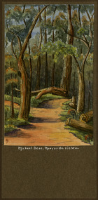 Marysville & District Historical Society
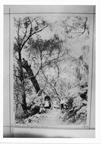
Painting (Item) - Watercolour painting, Miss I.K. Higgins, Michael Dene, Marysvile, Victoria, c1920
A watercolour painting of the Michael Dene walking track in Marysville in Victoria.A watercolour painting of the Michael Dene walking track in Marysville in Victoria by a Miss I.K. Higgins of Geelong in 1920. The Michaeldene Trail to Taggerty River Lookout is a 4.3 kilometer lightly trafficked loop trail located near Marysville, Victoria. The track is one of several walking tracks located in and around Marysville in Victoria.Michael.Dene.Marysville.Victoria Donated / by/ Elsie Stephens/ Mornington Painted by/ Miss I.K. Higgins/ of Geelong/ cc. 1920michael dene walking track, marysville, victoria, i.k. higgins, taggerty river -
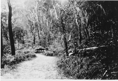 Halls Gap & Grampians Historical Society
Photograph - Sepia, C 1920s
C 1920s. Photo shows the jinker track which was replaced by the Mt Victory Road (then called Bluff Rd) during the 1920s.Photo shows a track through bush. An old car sits off to side of road just after a bend.access routes, roads, access routes, jinker track -
 Melbourne Tram Museum
Photograph - Black & White Photograph/s, early 1950's?
Black and white photograph of W5 No. 779 inbound to the City and Domain Road on route 56, on the open ballasted track just before passing under the railway line at the Zoo gardens area. Shows the open doors with the bars down. Photo of the tram slightly out of focus. Taken early 1950's by an unknown photographer. In the overhead shows a sign black cross in a circular disc and behind the tram a incandescent light suspended in the middle of the overhead. The photo shows the construction of the track at this location, dog spiked sleepers, the rail supports for the inner check rail. In the background behind the tram is the lever for the points of the crossover.On the rear in red ink "Melbourne tram shows use of Off-street tracks in an outer suburb"trams, tramways, zoo tram, reserved track, track construction, w5 class -
 Halls Gap & Grampians Historical Society
Photograph - B/W, C 1898
The picture shows Maggie Galbraith and five small children (identities unknown) beside a jinker track (bridal path) near Halls Gap.A woman and five small children, two boys and three girls, on a dirt track with trees and rocks on either side of it.access routes, jinker track, people, galbraith -
 Melbourne Tram Museum
Document - Research Notes, H. S. McComb, details of the Hawthorn system - part 1, 1950's
Set of papers - 12 foolscap and some quarto sheets - hand written in ink and pencil giving details of the Hawthorn system, distances, running times, streets used. Notes on Straun Robertson, depot layout, notes on track mileage, Wattle Park, construction, loop locations, sketches of track, the authorising Act, track lengths and calculations. Items 2037 to 2041 within box 72.3 in a brown folder marked "Hawthorn Tramway Trust" in red pencil.trams, tramways, htt, hawthorn, reports, routes, track, hawthorn depot -
 Melbourne Tram Museum
Photograph - Cable tram track demolition - Nicholson St Fitzroy, 1954/55
Photograph shows cable tram track being removed in Nicholson St to the north of Gertrude St. The cable tram engine house can be seen in the far distance. Photographer and date unknown - 1954/55.Yields information about the removal of cable tram tracks in Nicholson Fitzroy during 1954/55.Black and white photograph with notes on rearOn rear in pencil number "141" in pencil in top right hand corner and "Removing cable track ? St?".tramways, cable trams, nicholson st, trackwork, demolition -
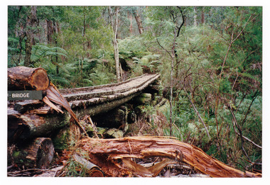 Marysville & District Historical Society
Photograph (item) - Colour photograph, 1996
A colour photograph of the timber tramway bridge along the Michaeldene Walking Track near Marysville in Victoria.A colour photograph of the timber tramway bridge along the Michaeldene Walking Track near Marysville in Victoria. The Michaeldene Trail to Taggerty River Lookout is a 4.3 kilometer lightly trafficked loop trail located near Marysville, Victoria. The track is one of several walking tracks located in and around Marysville in Victoria.1996timber tramway, michaeldene walking track, marysville, victoria, walking track