Showing 112638 items
matching tracks/roads
-
 Glen Eira Historical Society
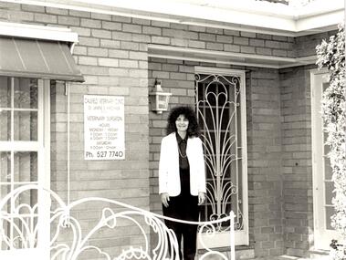
Document - Animals
... Corner Glen Eira and Hawthorn Roads, Caulfield, Victoria ...This file contains 2 items: 1/A black, white and green brochure titled ‘Leash Free Parks and Reserves’ concerning leashing regulations, conditions for non-leashing, summaries of legislation and penalties for owners of dogs, written by the City of Glen Eira. It includes six illustrations and a map of Glen Eira which labels all leash free parks as well as a depiction of all the train stations in the area. 2/A collection of 37 black and white photographs which have all appeared in Caulfield Contact at some time. These include photographs of the ‘Caulfield Veterinary Clinic, North Road Ormond dated 1982, Animal Control officer Reg Dixon dated 1982, draught horses pulling a horse drawn cart dated 1988 and general animals. Photographs unknown.allnutt park, murrumbeena park, veterinary clinics, professionals, veterinarians, kirschner jane s., north rd. ormond, dixon reg, animal control officer, horses, racehorses, racecourses, draught horses, bailey reserve, sporting grounds, bentleigh/hodgson reserve, boyd park, neerim road, caulfield park, caulfield race course, duncan mackinnon park, ee gunn reserve, glen huntly park, joyce park, king george v1 memorial reserve, lords park, marara road, marlborough street reserve, moorleigh, victory park, princes park, packer park, animal enclosures, domestic animals, dogs, horse drawn vehicles, cattle, birds, animals, trains, caulfield contact -
 Marysville & District Historical Society
Photograph (item) - Colour photograph, Pre 2009
A colour photograph of the walking track leading to Steavenson Falls in Marysville in Victoria.A colour photograph of the walking track leading to Steavenson Falls in Marysville in Victoria. The Steavenson Falls is named after the Victorian Assistant Commissioner of Roads and Bridges, John Steavenson who arrived in Victoria in the early 1860s.steavenson falls, waterfalls, marysville, victoria, john steavenson -
 Marysville & District Historical Society
Photograph (item) - Colour photograph, 20-09-2008
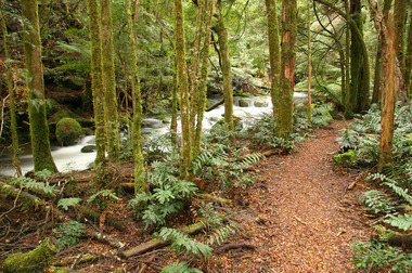
A colour photograph of the Beeches Rainforest Walking Track near Marysville in Victoria.A colour photograph of the Beeches Rainforest Walking Track near Marysville in Victoria. Starting from the spectacular Taggerty Cascades, the Beeches Rainforest Walk meanders through the ancient cool temperate rainforest of the Yarra Ranges. Dominated by Myrtle Beech trees and stands of Mountain Ash, it is home to the lyrebird which live on the forest floor.beeches rainforest walking track, marysville, victoria, taggerty river, taggerty cascades, yarra ranges, myrtle beech, mountain ash, lyrebird -
 Marysville & District Historical Society
Photograph (Item) - Colour photograph, 14-04-2002
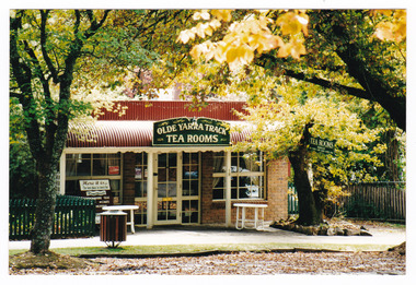
A colour photograph of the Olde Yarra Track Tea Rooms in Marysville in Victoria.A colour photograph of the Olde Yarra Track Tea Rooms in Marysville in Victoria. This building, along with most of the town, was destroyed in the 2009 Black Saturday bushfires.25/313 14.4.2002 AT MARYSVILLEmarysville, victoria, olde yarra track tea rooms, 2009 black saturday bushfires -
 Marysville & District Historical Society
Photograph (Item) - Black and white photograph, Unknown
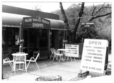
A black and white photograph of the Olde Yarra Track Shoppe in Marysville in Victoria.A black and white photograph of the Olde Yarra Track Shoppe in Marysville in Victoria. This building, along with most of the town, was destroyed in the 2009 Black Saturday bushfires.Mary Ferguson 70s + 80s.marysville, victoria, olde yarra track shoppe, 2009 black saturday bushfires -
 Marysville & District Historical Society
Document (Item) - Report, John F. Waghorn, Yarra Track, Unknown
A report on the history of the Yarra Track by John Waghorn, a local amateur historian.A report on the history of the Yarra Track by John Waghorn, a local amateur historian. John Waghorn was an amateur historian, an authority on the history of Victoria's postal services. He could tell you how mail was delivered in the high country in the 1880s, where the town of Gobur was, or when the overland Melbourne-Sydney mail service began. He admitted that his hobby has got a little out of hand. He had 30 filing cabinets, and indexes of more than 70,000 postal workers over the past 160 years crammed into three rooms at his home. If an ancestor was a postmaster in a Victorian town, he may have been able to reveal the person's occupation, income and working conditions.yarra track, john waghorn, victoria's postal services, wood's point, sydney road, longwood, merton, mansfield, postmasters, bonnie doon, melville merton mansfield, eltham, healesville, marysville, walhalla, melbourne-warburton-wood's point line, loose bags, heidelberg post office, eltham post office, kangaroo ground post office, yarra glen post office, marysville post office, healesville post office, mansfield post office, jamieson post office, gaffney's creek post office, wood's point post office, postal department, george rieck, stockman, jones, beecher, stockman's reward, big river, mary mcdonald, upper yarra river, donovan's creek, cornelius donovan, bridget buggy, matlock, alexandra, william farrell, jordan diggings, new chum, watts river, black spur, narbethong, granton, acheron river, mount strickland, paradise plains, mount grant, mount arnold, jordan goldfields, william robley, robley's spur, big river crossing, great dividing range, cumberland valley, james mcguigan, w elliot, christopher harrison, james marsh, cobb and co, box hill, lilydale, fehrings, koehlers, shaws, bear creek, cairnsville, cumberland creek, walkers, golden bower mine, collins' mountain home hotel, walsh's creek post office, rosa mcveigh, frank barton, hitchins, matthew kennedy, william morris, e r nichols, t woods, tom burchell, peter kerr, henry kuyper, william podlech, george koehler, henry brockmann, henry petty, thomas smith, jacob butchart, john perry, slingsby davis, royal mail hotel, walter gray, john summers, travellers rest hotel, lockington, the oaks, the springs, st clair, thomas crawford, springvale hotel, john sinclair, saint clair hotel, gould, mathews, willie we have missed you hotel, germany, johan fehring, adelaide, linton, ballarat, gunbower, murray river, anna katerina fehring, 1890s depression, land boom, fehring place, fred baker, alf sparke, fehring's hotel, mcveigh's hotel, wood's point mountaineer, l cox, victorian country directories, letson cox, coburg, maria hayes, setson, fitzroy, richmond, john cox, jordan river, jericho, e. norris, le poidevin, newell, o'brien, alhambra, sinclair, parker, ellis, tripp, quin, vernon, thompson, charsley, james fahie, george locke, william chester, chesterville, kirwan, cumberland reserve, blue spruce, e.s. and a bank, selby joyce, selby charles joy, selby joseph joyce -
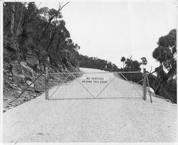 Halls Gap & Grampians Historical Society
Photograph - B/W, C 1960s (?)
... Roads ...A photo of the gate barring vehicle access to the top portion of the Mt William Road. The photo is part of a Ministry of Tourism campaign.The photo shows an iron gate across a road (Mt William Road). There is a man standing on the edge of the road in the background. A sign on the gate reads 'No vehicles beyond this point'.'Ministry of Tourism of Victoria, 276 Collins St., Melbourne, Nag. No.... , Date ..., Locality Grampians, Subject Gate-Mount William Road.' stamped on back.access routes, roads, scenery, mount william -
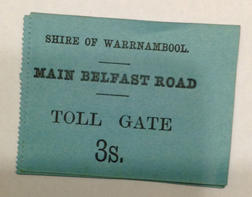 Warrnambool and District Historical Society Inc.
Document - Main Belfast Road Toll Gate Ticket Collection, 1860s
The Shire of Warrnambool operated toll gates from 1866 to 1869 as a means of raising revenue for road construction. There were three toll gate locations – on the main Belfast (Port Fairy) Road at Dennington Bridge, on the Woodford Road at Russells Creek and on the Geelong Road at the Allansford Bridge. The toll gates were unpopular and unprofitable for the lessees as travellers were able to avoid the tax by skirting around the gates. They had toll houses besides the tollgates. The printers of these tickets, William Fairfax and Henry Laurie, were the lessees at the time of the Warrnambool Examiner newspaper. This paper, founded by Richard Osburne and John Wilkinson, and published with some gaps from 1851 to 1880, is a key source today of Warrnambool’s history at the time. These toll gate tickets are significant because:- 1. They date back to the 1860s and were only issued from 1866 to 1869 2. They are the only artefacts we hold of the time when toll gates were operating in our local district 3. They are the best example of how the Shire of Warrnambool in its early history raised revenue for road building and maintenance. These are eleven toll gate tickets, ten for the Belfast (Port Fairy) Road toll gate and one for the Woodford Road toll gate. One is mounted on a Swintons store label (6 pence) and four are mounted on cardboard (2 shillings, sixpence, and two shillings and sixpence) and six are loose (three shillings, two shillings and sixpence and threepence). The Belfast Road tickets are yellow, green, blue and cream and the Woodford Road one is white. All have black printing. There is also an undated newspaper cutting with information on the toll gate tickets. Belfast Tickets: Shire of Warrnambool, Main Belfast Road, Toll Gate and the price Woodford Road: Shire of Warrnambool, Woodford Road, Toll Gate, 1s 6d Six of the eleven tickets also have ‘Fairfax and Laurie, Printers’ The sixpence ticket on card has the name R P Christian in ink written on the back of the card. shire of warrnambool, toll gates, r p christian, woodford road, main belfast road, swintons pty ltd -
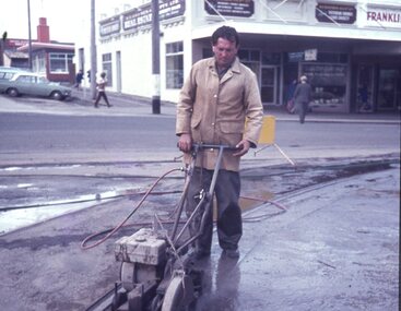
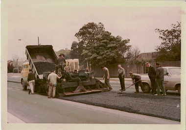 Kew Historical Society Inc
Photograph - Studley Park Road Reconstruction, 1968
One of a series of photographs donated by the City Engineer of the former City of Kew, relating to road works. The photos variably include council workers, signage and equipment.One of a series of photographs of core local government services as practised by the City of Kew. The photographs are an accurate record of street works of the period. This example is one of the few shot in colour in the 1960s. Original colour photographic positive of roadworks in Studley Park Road in the former City of Kew. A tip truck carrying bitumen unloads it contents on the road which is then levelled by a tray. Road workers supervise the road making. "STUDLEY PARK ROAD RECONSTRUCTION / 1 1/2" NOM [sic] SIZE BIT BINDER COURSE / JANUS CONSTRUCTIONS / 9TH OCT 1968"city of kew, local government -- city of kew, road works, street works, studley park road -- kew (vic.) -
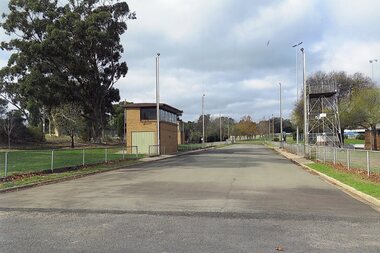 Stawell Historical Society Inc
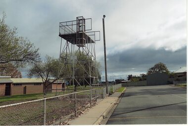
Photograph, Fire Brigade Training Track at North Park 2015 Looking East
Fire Brigade Training Track – North Park - 2015Colour Photograph of bitumen track used for fire fighting training. Looking weststawell -
 Stawell Historical Society Inc
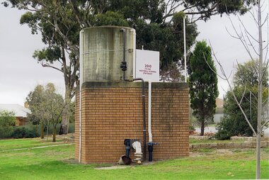
Photograph, Water Storage Tank at Fire Track
Fire Brigade Training Track – North Park - 2015Colour Photograph of bitumen track used for fire fighting training. Looking weststawell -
 Stawell Historical Society Inc
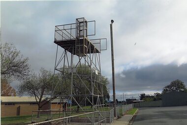
Photograph, Fire Brigade Training Track at North Park 2015
Fire Brigade Training Track – North Park - 2015Colour Photograph of bitumen track used for fire fighting training. Looking weststawell -
 Stawell Historical Society Inc
Photograph, Fire Brigade Training Track at North Park 2015
Fire Brigade Training Track – North Park - 2015Colour Photograph of bitumen track used for fire fighting training. Looking weststawell -
 Stawell Historical Society Inc
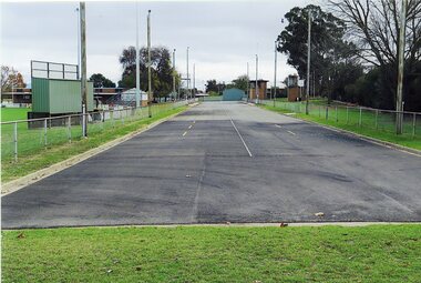
Photograph, Fire Brigade Training Track at North Park 2015 Looking west
Fire Brigade Training Track – North Park - 2015Colour Photograph of bitumen track used for fire fighting training. Looking weststawell -
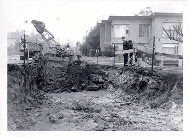 Kew Historical Society Inc
Photograph - Road works in the City of Kew, 1968-9
One of a series of photographs donated by the City Engineer of the former City of Kew, showing road works. The photos variably include council workers, signage and equipment.One of a series of photographs of core local government services as practised by the City of Kew. The photographs are an accurate record of street works of the period. Original black and white photographic positive of a road works in the former City of Kew. The photo shows an excavation in Studley Park Road near the corner of Carson Street in 1968/9. A Council officer and worker inspect the pit. Excavation equipment and a Council truck are at the back of the view. STUDLEY PARK ROAD AT CARSON STREET 1968/9city of kew, local government -- city of kew, road works, street works, kew city depot, studley park road -- kew (vic.) -
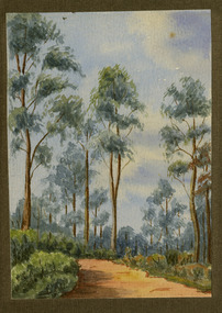 Marysville & District Historical Society
Painting (Item) - Watercolour painting, Miss I.K. Higgins, c1920
A watercolour painting of a track through a forest.A watercolour painting of a track through a forest.Painted by/ I.K. Higgins/ c.1920watercolour painting, i.k. higgins, forest -
 Marysville & District Historical Society
Painting (Item) - Watercolour painting, Miss I.K. Higgins, c1920
A watercolour painting of a track through a forest.A watercolour painting of a track through a forest.Painted by/ I.K. Higgins/ c.1920watercolour painting, i.k. higgins, forest -
 City of Kingston
Photograph - Black and white, c. 1958
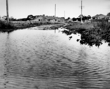
... Roads ...This photograph depicts flooding of Ozone Avenue in Beaumaris, located off Balcombe Road. Roads in the Beaumaris area lacked sufficient drains to clear surface water. In many cases streets were unsealed and without footpaths and some were dirt tracks. Gutters and road surfaces were made of clay and in the wetter months of winter, unsealed roads and tracks became impossible quagmires that were unnavigable for vehicles and pedestrians. In the first decade after World War II there was rapid expansion in construction of new houses in the suburb of Beaumaris. Utilities and infrastructure to support the growth of housing was inadequate and not provided for prior to the development of the area. Without rudimentary drainage, flooding was frequent. Storm water runoff, domestic sullage and septic tank overflow would form large pools and families were sometimes marooned within their homes. The frequent flooding caused isolation and hardship and residents endured difficulties with accessibility to facilities. These disadvantages had the potential to cause social issues for the new residents.Black and white photograph of flooding in Ozone Avenue, Beaumaris. The image shows floodwaters with boggy and rough terrain on an unsealed road with housing in the distance.Handwritten in blue ink: 2124 circled Handwritten in red ink: 80% Handwritten in blue ink on yellow Post-It note: Chap 6. underlined, 2194 Ozone Ave Beaumaris 1958beaumaris, ozone avenue, balcombe road, flooding, roads, infrastructure -
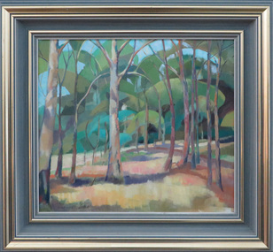 Federation University Art Collection
Painting - oil on masonite, David Alexander, Along Creswick Road, c1965
Creswick Road is in Ballarat.A painting of a landscape along Creswick Road, Ballarat by David Alexander. Gift of David Alexander, 2013Signed in ink lower left corner 'Along Creswick Road About 1965. D. Alexander'creswick road, ballarat, art, artist, david alexander, available -
![Construction of the electric tram line in Cotham Road [Kew]](/media/collectors/550653872162f11fb04854aa/items/662890b16214a76cee3ec4c2/item-media/662891076214a76cee3ed17d/item-fit-380x285.jpg) Kew Historical Society Inc
Kew Historical Society IncPhotograph - Construction of the electric tram line in Cotham Road [Kew], E.J. Dower, 1913
One of a small album of six photographs of the construction of the Cotham Road tramline in Kew, taken by Edgar James Dower in the second decade of the twentieth century. The reverse of each photo contains notes, written over time by the photographer, which are contained in the 'Inscriptions' field. Born and raised in Olinda, Dower's family later moved to Surrey Hills. He worked as an adult as a clerk in the city office of the Metropolitan Gas Company, and in his role as a 'collector', he was able to photograph scenes including the construction of tram and train lines and associated buildings in Kew, Hawthorn, Camberwell and Surrey Hills. Later he established a real estate agency with his brother - the E.J. Dower Real Estate Agency, Dandenong Office. The album as a whole can be viewed separately as the parent file.The image is an historically significant record of the development of transport infrastructure which was used to connect Victorians in the first two decades of the twentieth century. This development resulted from increases in population and the consequent extension of Melbourne's suburbs. The photographs in the album, as well as Dower's single photos mounted on card, individually and collectively richly detail the labour of workers and the tools and machinery used to create and extend Melbourne's tram and train networks in the years preceding and during World War 1.The fifth of six annotated photos in an album of photographs of the construction of the St Kilda to Kew electric tram line, taken in Cotham Road, Kew, by the amateur photographer, Edgar James Dower, in 1913. The album contains images detailing the preparation for the laying of the tracks plus work laying the line. The photographer notes on a number of the photos that the metal tracks were collected from the Hawthorn railway siding. The album, together with other phots by E.J. Dower has been made available by the owners for the Kew Historical Society to digitise and publish online and in print.Annotation verso: "Preparing tram line Cotham Road Kew for electric trams, looking west / 1913"keywords, theme -- connecting victorians by transport and communications, theme -- travelling by tram, photographers -- edgar james dower, cotham road -- kew (vic.) -
 Geelong Cycling Club
Archive - Track Bike, 1949
Track cycle built by Eugene Cowley in 1949 for Ken Jenkin from the Geelong Amateur Cycling Club.Gene Cowley began building cycles in the 1890s and continued until the middle 1950s. He was the first president of the Geelong Amateur Cycling Club.Velos Track and Road Cycle. It has a steel frame, steel rims, rubber tyres, Brookes saddle, pedals with toe straps, handle bars for track racing and dual brakes. This machine is equipped with an early derailler gear- note change lever on down tube. The frame is painted grey and has a Velos badge on the seat stem and a V in white with a red background on the head stem. The word Velos is also outlined on the frame in white with red shadowing."Velos/V"ken jenkin; eugene cowley; geelong amateur cycling club; track cycle; velos track and road cycle; brookes saddle; geelong cycling club; -
Canterbury History Group
Photograph - New Overpass, 1968
Photocopy of a train crossing on the up track of the Canterbury Road overpasscanterbury, canterbury road, canterbury station, trains, railway crossings -
 Ballarat Tramway Museum
Slide - 27 mm sq slide/s - set of 7 - track removal, Lilian Butler, c1971 to 1972
Series of 7 photos showing track removal following the closure of the Ballarat Tram system.Yields information about the removal of the tram tracks in the city area.Set of 7 colour slides - 1 x Agfa blue and white plastic slide mount, 4 Hanimex cardboard mounts and 2 Kodachrome cardboard mounts of track removal works in Ballarat, c1971 to 1972 .1 - Saw cutting the road pavement at the Dawson St Crossover. .2 - Rolling the crushed rock pavement in Sturt St after track removal - near Doveton St. .3 - Track repairs or starting to remove the railway crossing at Lydiard St North - has an SEC truck in the background and the Kennedy Murray Pty Ltd General Carriers building in the background. .4 - commencing work on the Dawson St Crossover removal with St Patrick's Cathedral in the background. .5 - as for .2 .6 - L. G. Pearce excavating track near Dawson St. .7 - ditto Photo from the collection of Lilian Butler. ballarat, tramways, trams, track removal, dawson st, trackwork, sturt st, level crossings, lydiard st north -
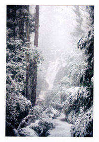 Marysville & District Historical Society
Photograph (item) - Colour photograph, Pre 2009
A colour photograph of the walking track which leads to Steavenson Falls after a snowfall.A colour photograph of the walking track which leads to Steavenson Falls after a snowfall. The Steavenson Falls are named after the Victorian Assistant Commissioner of Roads and Bridges, John Steavenson who arrived in Victoria in the early 1860s.steavenson falls, waterfalls, marysville, victoria, snow, john steavenson -
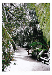 Marysville & District Historical Society
Photograph (item) - Colour photograph, 2007
A colour photograph of the walking track which leads to Steavenson Falls after a snowfall.A colour photograph of the walking track which leads to Steavenson Falls after a snowfall. The Steavenson Falls are named after the Victorian Assistant Commissioner of Roads and Bridges, John Steavenson who arrived in Victoria in the early 1860s.March 2007 Pathway to Fallssteavenson falls, waterfalls, marysville, victoria, snow, john steavenson -
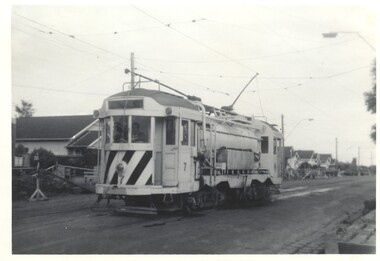 Melbourne Tram Museum
Photograph - Track cleaner 7 - East Coburg, Bob Lilburn, 24-4-1966
Photo shows MMTB Track cleaner No. 7 on the east Coburg Route in use during roadworks. The tram was fitted with cabins of W2 class trams when built. It is now at the TMSV Bylands site.Demonstrates the use of a track cleaner tram No. 7Photograph - Track cleaner 7 - East Coburgin ink on rear - MMTB - No. 7 - East Coburg Route 24-4-66 R Lilburn Photo.tramways, works trams, track cleaner, tram 7, east coburg -
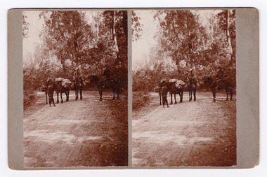 Marysville & District Historical Society
Photograph (Item) - Black and white bi-focal image, Unknown
An early black and white bi-focal image of men and packhorses on the Marysville-Wood's Point Road in Marysville in Victoria.An early black and white bi-focal image of men and packhorses on the Marysville-Wood's Point Road in Marysville in Victoria. This is now known as the Marysville-Wood's Point Road. The Marysville-Woods Point Road was originally part of the Yarra Track, constructed in the early 1860s to provide access between Healesville and the Woods Point Goldfields. Despite the steep terrain and engineering difficulties, the Yarra Track soon became a busy route used by pack horses, horse-drawn drays, and wagons. Today this sealed mountain road is a popular scenic drive between Marysville and Warburton.Packhorses on Wood'spoint Road/ Marysville/ Victoriapackhorses, wood's point road, marysville-wood's point road, marysville, victoria, yarra track, healesville, wood's point goldfields, warburton -
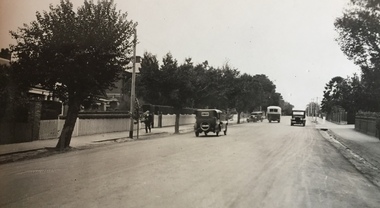 Kew Historical Society Inc
Photograph - Street Works, Studley Park Road, March 1934
Studley Park Road, like most streets in Kew, was originally a dirt road. Street works during the Great Depression included bituminising major roads in the district. This photograph of Council works originated in the City of Kew Engineers Department as a record of works undertaken. It was given to the collection by a Mrs Fisher in 1998.Well provenanced photograph of Council-funded public works in Kew during the Great Depression. Original sepia monochrome positive of Studley Park Road, Kew.Typed reverse: "B4 / Kew C.C. / Studley Park Road after surfacing with one coat of premixed material spread with drag, March 1934"roadworks -- kew (vic.), street works -- kew (vic.), public works kew (vic.), studley park road -- kew (vic.), city of kew -- engineers department, city of kew -- public works -- great depression -- 1930s -
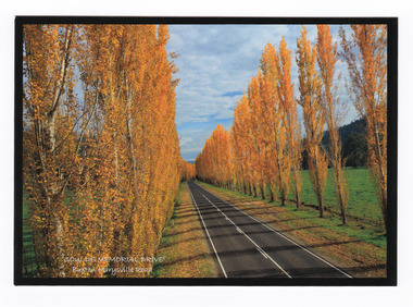 Marysville & District Historical Society
Postcard (item) - Colour postcard, Donovan Wilson, 'GOULDS MEMORIAL DRIVE'- Buxton Marysville Road, Post 2009
A colour photograph taken of Gould Memorial Drive on the Buxton Marysville Road in Victoria.A colour photograph taken of Gould Memorial Drive on the Buxton Marysville Road in Victoria. The planting of the avenue of Lombardi Poplars was initiated by Mrs Joy Gould and the trees were planted by workers of the Gould Mill. The intention was for the avenue to extend from Marysville to Buxton. However, this was never fully realised. In Autumn the trees turn a brilliant yellow and are a major tourist attraction. This postcard was produced by Donovan Wilson Photography as a souvenir of Marysville.Gould Memorial Drive/ Buxton Marysville Road/ Marysville Donovan Wilson/ Photography Place/ Stamp/ Heremarysville, buxton, poplar trees, gould memorial drive, donovan wilson, postcard, souvenir, marysville-buxton road -
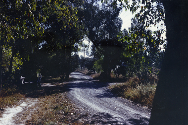 Whitehorse Historical Society Inc.
Photograph, Glenburnie Road, Vermont, 1967
Part of Tim Shambrook's Collection for 'This is Vermont'. Not used.Coloured photo of Glenburnie Road, Vermont, taken in 1967, showing dirt track before road was made.glenburnie road, vermont, shambrook, tim