Showing 1002 items
matching tramway maps
-
 Victorian Railway History Library
Book, Armstrong, John et al, 1973
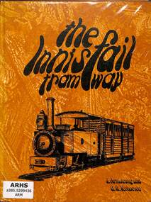
The story of the history and development of the Geraldton Shire Tramway and the Mourilyan Tramway of North Queensland.ill, maps, p.103.non-fictionThe story of the history and development of the Geraldton Shire Tramway and the Mourilyan Tramway of North Queensland.railroads - queensland - history, tramways - australia -
 Victorian Railway History Library
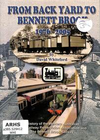
Book, Whiteford, David, From Back Yard to Bennett Brook 1976-2005
A history of the Western Australian Light Railway Preservation Association and the railway and tramway preservation at the Bennett Brook Railway near Perth in Western Australia.ill, maps, p.52.non-fictionA history of the Western Australian Light Railway Preservation Association and the railway and tramway preservation at the Bennett Brook Railway near Perth in Western Australia.preserved locomotives - western australia - history, preserved trams - western australia - history -
 Victorian Railway History Library
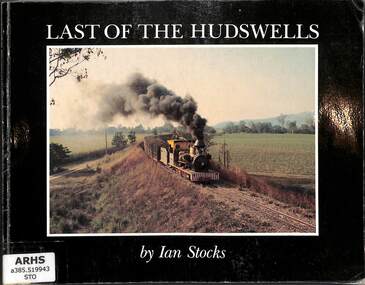
Book, Stocks, Ian, The Last of the Hudswells, 1982
A pictorial tribute to the last ten years of CSR Limited's 2' gauge Hudswell Clark steam locomotives working on the sugar mill railways of the Herbert River Valley around Inghamill, maps, p.98.non-fictionA pictorial tribute to the last ten years of CSR Limited's 2' gauge Hudswell Clark steam locomotives working on the sugar mill railways of the Herbert River Valley around Inghamsteam locomotives - queensland - history, sugar tramways - queensland - history -
 Melbourne Tram Museum
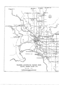
Drawing, Melbourne & Metropolitan Tramways Board (MMTB), "MMTB Electric Tramway System 1979", 1979 original
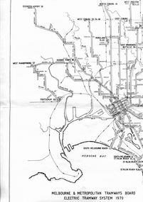
... See item 7740 for an original print. Trams tramways MMTB ...See item 7740 for an original print.Digital image of a drawing titled "MMTB Electric Tramway System 1979", giving a detailed layout of the Melbourne tram system in 1979. shows depot, storage depots, workshops and tramway terminus names and route numbers. See htd253i.pdf for a high definition pdf file - this does not open on this system - Two page document. See Reg Item 1765 for a 1971 copy.trams, tramways, mmtb, melbourne, map, routes -
 Melbourne Tram Museum
Drawing, Melbourne & Metropolitan Tramways Board (MMTB), "Melbourne & Metropolitan Tramways Board Electric Tramway System 1979", 1979
... Trams tramways Melbourne Map Trackwork Depots Route Numbers ...Photocopy of the track plan for the Melbourne Tramway System in 1979 over two separate sheets - titled "Melbourne & Metropolitan Tramways original pr Board Electric Tramway System 1979". Shows the route numbers and terminus names, depot locations, rail lines, cross overs and junctions. Has the name J.Chau in bottom left hand corner. See item 7740 for an original print.trams, tramways, melbourne, map, trackwork, depots, route numbers, railways, junction -
 Victorian Railway History Library
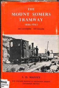
Book, Maffey, I.D, The Mount Somers Tramway 1886-1943, 1971
A history of the Mount Somers Tramway in the mid-Canterbury region of the South Island of New Zealand.index, ill, maps, p.113.non-fictionA history of the Mount Somers Tramway in the mid-Canterbury region of the South Island of New Zealand.railroad construction - new zealand, railroad operations - new zealand -
 Victorian Railway History Library
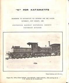
Booklet, Australian Railway Historical Society (Victorian Division), K For Katamatite, 1965
Tour notes for a train trip to Katamatite branch line from Shepparton in Victoria. A trip run by the Australian Railway Historical Society Victorian Division on Saturday 21th August 1965ill, maps, p.8.non-fictionTour notes for a train trip to Katamatite branch line from Shepparton in Victoria. A trip run by the Australian Railway Historical Society Victorian Division on Saturday 21th August 1965railroad construction - victoria - history, katamatite tramway - railway - history -
 Melbourne Tram Museum
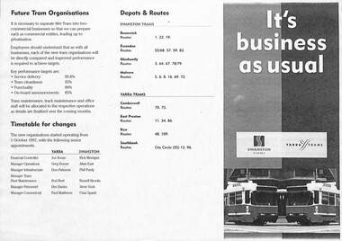
Pamphlet - PTC split, Public Transport Corporation (PTC), It's business as usual, 9/1997
Gives details of the split of the tram division of the Public Transport Corporation Vic to come into effect on 1-10-1997 into two business divisions - Yarra Trams and Swanston Trams. Includes a map showing which entity was to operate what section of Melbourne Trams. Prepared for employee information. Provides information on who would be the senior managers, a timetable, depots and routes to be operated and the logos that would be used.Yields information about the split of the Public Transport Corporation Tram division in preparation for the future privatisation. Pamphlet - photocopy titled Pamphlet - It's business as usual about the split up of the PTC to Swanston Trams and Yarra Trams. Two copies held.trams, tramways, yarra trams, swanston trams, ptc, managers, depots, public transport corporation -
 Melbourne Tram Museum
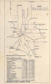
Map, Melbourne cable tram system, 1971?
... the Melbourne Cable Tram system. tramways cable trams trams map ...Map showing the Melbourne cable tram system, with a list of opening and closing dates for the various lines, opened by the Melbourne Tramways Trust. Shows engine houses and car houses (or depots), location names, railways, and a scale. Includes notes on other dates tracks were changed and the Northcote to Clifton Hill line. No marks as to who prepared the map.Yields information about the Melbourne Cable Tram system.Foolscap sheet - Map - Melbourne cable tram system showing tracks, car houses and engine houses.Has a date stamp 22 Apr 1971 in bottom right hand corner.tramways, cable trams, trams, map, melbourne tramways trust, mtt, engine houses, depots, car houses -
 Melbourne Tram Museum
Ephemera - Ticket - City Saver, The Met, 1988c
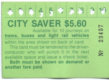
Used by The Metropolitan Transport Authority (The Met) to provide a multi-journey trip ticket within a nominated City (CBD) area. Has been used for 10 trips. A check ticket was issued by a conductor for each trip made. Has details of the availability on the rear. Notes that the ticket is available for trams, buses and light rail. Previous issues did not have light rail listed. The light rail to St Kilda and Port Melbourne commenced in Nov. 1987. Has The Met logo on the rear. Demonstrates a multi-use ticket used by The Met in the City area of Melbourne.City Saver –No. 23457 - $5.60 printed on a green card with a map of the available CBD travel area on the back.public transport, tickets, the met, trams, tramways, city saver -
 Melbourne Tram Museum
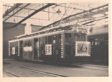
Photograph - Melbourne W1 421 decorated for the visit of the Duke and Duchess of York, Melbourne & Metropolitan Tramways Board (MMTB), 1927
Photograph and associated infomation of Melbourne W1 421decorated as an "illuminated" tramcar for the visit of the Duke and Duchess of York to Victoria April 21 to May 12, 1927 and the opening of Canberra on May 9, 1927, taken at Preston Workshops. Associated Digital images: .2 - extract from the 1926-27 MMTB Annual Report. .3 - image from the David Featherstone collection of the tram being fitted out at Preston Workshops .4 - image of the tram at night, from the Annual Report. Note Tasmania is missing from the map on the side of the tram. Yields information about the decoration of a Melbourne tram for a Royal visit in 1927 Black and White photograph of Melbourne W1 421decorated as an "illuminated" tramcar for the visit of the Duke and Duchess of York 1927illuminated trams, decorated trams, royal visit, duke of york, preston workshops, w1 class, mmtb, tram 421 -
 Melbourne Tram Museum
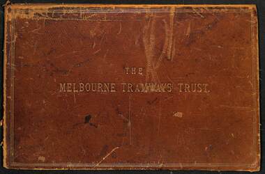
Document - Folder, Kemp & Boyce Printers, "Melbourne Tramways Trust - Cable Tramways", March 1889
... Tramways Trust showing details of the track construction, drainage ...Plans and documents prepared by George Duncan for the Melbourne Tramways Trust showing details of the track construction, drainage and costs for the construction of the Melbourne cable tram and horse tram system for the Melbourne and Tramway Omnibus Co. Part 1 - track cross sections for both cable and horse trams and various rail weights - lbs/yard part 2 - details costs and mileages for each liine, report from George Duncan and remnant part of a printed map missing the lower half. part 3 - drainage report detailing the works and cost for each line. part 4 - continuation of drainage report - and last part of the book Map printed on cloth - blue print - showing the various lines. Note the Windsor to St Kilda line shown as a horse tram line, but was built as a cable line - the last to be opened.Yields information about the construction of the cable tram system by the Melbourne Tramway TrustFolder - heavy card leather covered covers with gold lines around the edges and gold blocked title. Has marbled glued end papers, containing 9 cloth backed blue print drawings, 22 printed sheets and two foldout maps. The lower half of the first fold out map has been torn out and lost. The second fold out map, a cloth backed blue print.Date stamped in two places with "The Melbourne Tramways Trust Engineers 9 Mar 89" (1889), in two places.tramways, trams, cable trams, mtt, mtoco, melbourne tramway trust, construction, drainage, maps, george duncan, track work, costs -
 Melbourne Tram Museum
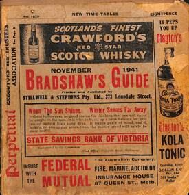
Book - Bradshaws Guide - November 1941, Stillwell & Stephens Pty Ltd
Provides detailed information on Victorian railways country timetables, suburban trains, lists of post offices, Victorian and Commonwealth Government officials and elected representatives, and tramways - all night services, first and last cars, including Sandringham and St Kilda services. Provides a detailed guide to services in Victoria, including public transport.Book - 194 pages, 9 sections stapled paper titled "Bradshaws Guide - November 1941" Priced 8d, No. 1029. Has a fold out map of the VR Country and suburban lines. Includes many advertisements.victoria, tramways, melbourne, timetables, railways, guides, bradshaws guide, advertisements -
 Melbourne Tram Museum
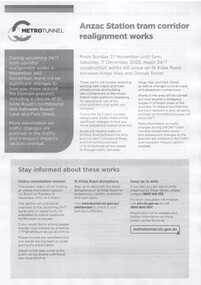
Pamphlet - Metro Tunnel - Anzac Station tram corridor works, Rail Projects Victoria, 11/2022
Provides information about the works planned to realign tram tracks at the Metro Tunnel Anzac station, following the completion of the surface works. Gives timing, tram routes affected, plans of the proposals, contact details. All St Kilda Road routes would be affected from 27/11/2022 to 17/12/2022, tram stops would be closed, bus replacement services. includes works to remove the Glenhuntly Road level crossing at Glenhuntly Station. Yields information about the trackworks for the future Anzac Station interchange and St Kilda Road services.Set of two documents issued by Rail Projects Victoria (Metro Tunnel) and Yarra Trams with regard to the reallignment of tram tracks at Anzac Station Nov. 2022 1 - Metro Tunnel - Works proposed, maps - 6 A4 pages 2 - Yarra Trams - Service Changes St Kilda Road works - 4 A4 pages.anzac station, metro tunnel, tramways, st kilda road, domain road, domain interchange, park street, track work, tram tracks, glenhuntly road, glenhuntly station, level crossings -
 Melbourne Tram Museum
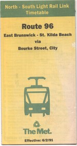
Document - Timetable - Route 96 - East Brunswick - St Kilda Beach, The Met, 2/1991
Timetable dated 6-2-1991 provides information on the East Brunswick to St Kilda Beach via Bourke Street services, including a map, route description, time points, fare secrtions and contact details. Published by The Met. Has the words "North-South Light Rail Link" on the top of the document. Yields information about Route 96 tram services on the St Kilda light rail line.Document - 10 fold sheet - Timetable - Route 96 - East Brunswick - St Kilda Beachtramways, timetable, route 96, east brunswick, st kilda beach, light rail, the met -
 Melbourne Tram Museum
Document, Ministry of Transport, Melbourne Public Transport Map - No. 12, 1982
Map No. 12 - Includes description of tram and bus routes, private bus routes. On the front cover is composite image of Melbourne public transport vehicles. Has contact details for bookings and lost property etc and how to use the map. Priced at 40c, issue No. 12 of c1982. Has details of the then new Travelcard ticket system. Yields information about Melbourne public transport services in 1982.Fold out map (36 sections 9 across x 4 deep), "Public Transport Map", coloured of Melbourne's Tram and Bus routes, route numbers, rail lines, detailed for the central part of Melbourne and the outer Metropolitan services.tramways, melbourne, tram services, bus services, railways, travelcard -
 Melbourne Tram Museum
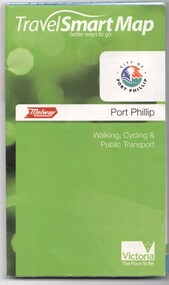
Document, Ministry of Transport, "Travel Smart Map - Port Phillip", 2010
Gives extensive details of walking cycling Public Transport in Port Phillip. Printed 2010. Yields information about Port Phillip transport and other services in 2010Map - pocket - 28 fold - showing walking, cycling and public transport in the City of Port Phillip, using a Melway Map base along with public transport information, Metcard, cycling and walking groups.tramways, melbourne, tram services, bus services, railways, port phillip, cyclists -
 Melbourne Tram Museum
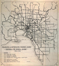
Drawing, Robert Green, Melbourne and Metropolitan Tramways Board Proposals for General Scheme, 2-1968
Drawing prepared by Robert Green for the TMSV showing the MMTB Proposals for tramway construction in the Melbourne Metropolitan Area. Traced and redrawn from the original drawing dated 27-8-1923. Shows the proposed tram lines submitted to Parliament for the report into the General Scheme as required by the MMTB Act when it was formed. See items 2088 for the original report and 2089 for a coloured print of this plan. Demonstrates the MMTB General scheme and a copy that could be used to produce further copies.Drawing - ink on mylar film.trams, tramways, mmtb, general scheme, development, parliamentk, map -
 Melbourne Tram Museum
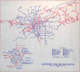
Map, Melbourne & Metropolitan Tramways Board (MMTB), "Melbourne tram and bus routes", c1961
... . Yields information the MMTB services c1961. tramways map mmtb ...Map showing MMTB tram and bus routes following the closure of the Point Ormond line on 22/10/1960 and before the closure of the Footscray lines on 10/3/1962. Shows route numbers at termini and along the route and points of interest in a reference table. Yields information the MMTB services c1961.Map - printed in two colours on paper. Two copies held.tramways, map, mmtb, tram, bus, routes -
 Port Melbourne Historical & Preservation Society
Map - MMBW, c. 1894
Melbourne and Metropolitan Board of Works 1894, Plan number 18 Segments Shown: Between 322 - 486 Smaller scale map incorporating piers, lagoon and town north to beyond boundaryIn pencil: "7/7/94" (Which is the copyright date)engineering - board of works, piers and wharves - railway pier, piers and wharves - town pier, sandridge lagoon, transport - tramways, transport - railways, gasworks, built environment -
 Melbourne Tram Museum
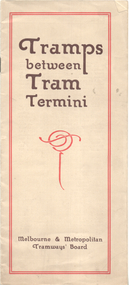
Booklet, Melbourne & Metropolitan Tramways Board (MMTB), "Tramps between tram termini", c1930
Booklet - promoting tram travel and walking trips or "tramps" between various tram terminus. Includes notes on the Board's services, its tourist tram with notes and fares on specific walks. Includes a map and some photos for each walk. 1 - Brighton Road to Hawthorn 2 - Burwood to Mont Albert 3 - Carnegie to Darling Road 4 - Whitehorse Road to East Kew 5 - Glen Iris to Darling Road 6 - Maribyrnong River to Mt Alexander Road 7 - Gardiner or Glen Iris to Burwood 8 - Wallen Road Bridge to Glenferrie Road 9 - Johnston St Bridge to Victoria Bridge At the time, some of these walks would have been through largely undeveloped land and parks.Demonstrates a promotion of the MMTB tram services and leisure activities.Booklet - 16 pages, two colours on light fawn paper, centre stapled.tramways, showgrounds, william st, mmtb -
 Melbourne Tram Museum
Map - CD - Sands McDougal Map Melbourne c1906, Sands McDougall
... Melbourne and its tramways in 1906 cable trams tramways map Sands ...Detailed scan of the Sands McDougal Map in colour showing Melbourne's cable trams, railways, Essendon Tramways, NMETL and the Victorian Railways line to Brighton from St Kilda. Includes the MTOCo horse tram lines and the Caulfield horse tram lines. See Reg item 6572 for the actual map. Yields information about Melbourne and its tramways in 1906CD in a plastic case - black with clear cover.CD marked "Sands & McDougal Map c1906"cable trams, tramways, map, sands mcdougal, nmetl, vr trams, horse trams -
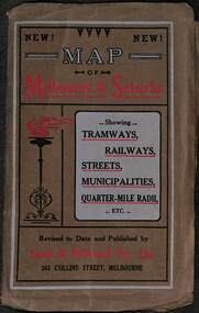 Melbourne Tram Museum
Map, Sands McDougall, Map of Melbourne and Suburbs showing Tramways, Railways, Streets, postal districts, Quarter-Mile Radii etc", c1919
... cover titled "Map of Melbourne and Suburbs showing Tramways ...Shows railways, cable and electric tram lines c1919. One of a number of maps produced by Sands McDougall of Collins St. Includes the MTOCo zoo horse tram lines, the PMTT, HTT and MBCTT lines, but not the FNPTT or the FTT lines. See items 2885 and 6573 for other editions. Yields information about Melbourne c1919 and its public transport lines. Produced by Sands and McDougall Pty Ltd of Collins St Melbourne. folded sheet of paper 6 sections wide x 6 sections or folds deep contained within a brown paper cover titled "Map of Melbourne and Suburbs showing Tramways, Railways, Streets, postal districts, Quarter-Mile Radii etc", showing both cable and electric tramways. maps, melbourne, cable trams, tramways, railways, horse trams, nmetl, vr trams, sands mcdougall, mbctt, pmtt, htt, zoo horse tramway -
 Melbourne Tram Museum
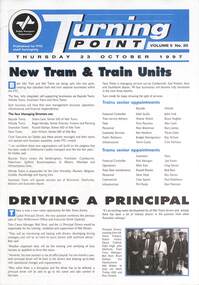
Magazine, Public Transport Corporation (PTC), Turning Point, 23-10-1997
Magazine - issued by the Public Transport Corporation announcing the split up of The Met into the parts that facilitated the later franchising of the trains and trams. Created Yarra Trams and Swanston Trams and Hillside and Bayside trains. Includes a map of the two systems, lists the senior positions and their names. Includes the launch of Principal Drivers for trains, sporting news, operator performance delivery statistics, Transcom adverts and Bairnsdale line upgrade.Yields inforamation about split up of the PTC in readiness for future franchising. Magazine - three fold to A4 sheet, printed in two colours.tramways, tramcars, yarra trams, swanston trams, ptc, bayside trains, hillside trains, management, managers -
 Melbourne Tram Museum
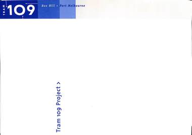
Document - Opening of Box Hill Extension Route 109 Press documents, Ministry of Transport, May 2003
Produced for the opening of the Box Hill Extension, 2 May 2003, extending the tram line from Union Road Mont Albert to Station Street Box Hill. Became known as Route 109 - Port Melbourne Box Hill.Provides the background to the 2003 extension of the Mont Albert tram to Box Hill.Documents - mainly folded to A4 enclosed within a card folder prepared for the event. .1 - folder - folded card to hold the following items .2 - 10 fold DL pamphlet providing map, technical information and tram stops. .3 - A2 folded sheet for the Route 109 project - introduction by the Minister for Transport, Peter Batchelor .4 - A3 folded sheet giving background history to the area .5 - 2 page Press Release dated 2/5/2003 .6 - A4 sheet with CD containing a photo of the 30/9/1916 Opening by Mr. A Bailey trams, tramways, new tramway, box hill, opening, route 109, mont albert -
 Melbourne Tram Museum
Map, Ministry of Transport, Melbourne Public Transport Map - No. 9, 1979
Map No. 9 - Includes description of tram and bus routes, private bus routes. Has contact details for bookings and lost property etc and how to use the map. Yields information about Melbourne public transport services in 1979Fold out map (27 sections 9 across x 3 deep), "Public Transport Map", coloured of Melbourne's Tram and Bus routes, route numbers, rail lines, detailed for the central part of Melbourne and the outer Metropolitan services.tramways, melbourne, tram services, bus services, railways, travelcard, maps -
 Melbourne Tram Museum
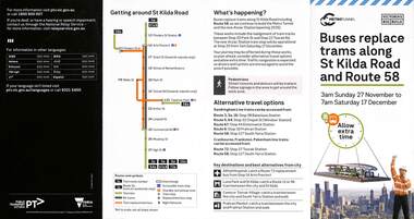
Pamphlet, Public Transport Victoria (PTV), Buses replace trams along St Kilda Road and Route 58, Oct. 2022
Pamphlet - Buses replace trams along St Kilda Road and Route 58 - issued for the track relocation at Domain Junction / Anzac station during the period 27-11-2022 to 17-12-2022. Actual work took a day longer due to weather. Similar pamphlets would have been issued for other routes that used St Kilda Road. Includes maps, alternative routes. Issued by Public Transport Victoria. Part of the Metro tunnel works.Yields information about the reconstruction of Domain Junction for the future Anzac station.Pamphlet - four fold DL - full colour on semi gloss paper. Two copies held.tramways, route 58, anzac station, domain interchange, track work, bus replacement -
 Melbourne Tram Museum
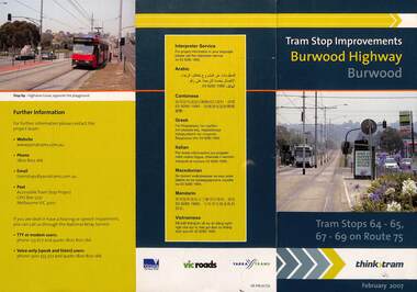
Pamphlet, VicRoads, "Tram stop improvements Burwood Highway Burwood", Feb. 2007
Pamphlet dated Feb. 2007 detailing the installation of platform or super stops in Burwood Highway Burwood in four locations. Has location map. Part of the VicRoads Yarra Trams Think Tram project. Route 75.Yields information about the installation of super stops in Burwood Highway during 2007.Pamphlet - 3 fold DL - full colour.trams, tramways, super stops, platform stops, route 75, burwood highway, burwood -
 Melbourne Tram Museum
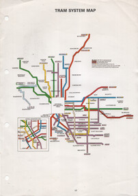
Map, The Met, "Tram System Map", c1990
... system map published by The Met to show the various Melbourne ...Tram system map published by The Met to show the various Melbourne tram routes, route numbers, principal road names, suburbs and tram routes within the Central Business District.Provides information about Melbourne tram routes c1990Printed A4 full colour sheet with four punch holes on left hand side.tramways, melbourne, the met, map, tram routes, routes -
 Bendigo Historical Society Inc.
Document - BASIL MILLER COLLECTION: MAP - CHARING CROSS
Map showing Charing Cross, Bendigo area. Details written suggest plans for an ANZAC Day Service. Cream coloured paper and black print with additions written by hand in blue ink. Numerous markings in blue ink on front. 'the Manager, SEC, Hargreaves Street Bendigo, ref. Tramways' on reverse.basil miller, bendigo trams, state electricity