Showing 176549 items
matching will street
-
 Tatura Irrigation & Wartime Camps Museum
Photograph, Daryl Walker, Tatura Milk Products, 1986
Tatura Milk Products, formerly Butter Factory was founded in 1907.Black and white photograph of Tatura Milk Products, Hogan Street, Tatura. Office and part of factory. 2 flags flying. 2 females in foreground.on back: Tatura Milk Products, Hogan Street, Tatura. 1986. Same title on sign in photograph.tatura milk products, butter factory tatura -
 Kew Historical Society Inc
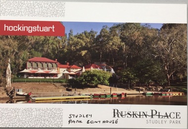
Postcard, Ruskin Place, Studley Park, c.2010
The Kew Historical Society's postcard collection includes views of Kew, Melbourne and Greater Melbourne as well as those including overseas scenes sent or received from Europe or the Middle East. They date from the 1890s to the 2000s.Commercial postcard produced by Hocking Stuart to advertise Ruskin Place, 75 Princess Street, Kew, but instead showing the Studley Park Boat House.The reverse includes advertising copy relating to the company and to Ruskin Place, 75 Princess Street, Kew.ruskin place - kew, 75 princess street - kew, studley park boat house -
 Marysville & District Historical Society
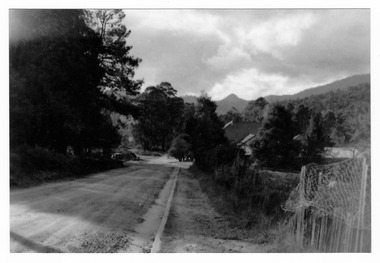
Photograph (Item) - Black and white photograph, Kathleen & Tom Minahan, 1948
A copy of a black and white photograph looking towards Murchison Street in Marysville in Victoria.A copy of a black and white photograph looking towards Murchison Street in Marysville in Victoria. The view is looking down Lyell Street.murchison street, lyell street, marysville, victoria -
 Greensborough Historical Society
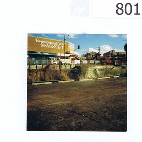
Photograph, Corner Para Road and Main Street Greensborough c1993, 1993_
The photograph shows road works on the corner of Para Road and Main Street Greensborough in 1993.The view also includes the Greensborough Hotel, the valley Buildings and the group of shops on the Para Rd corner named as Greensborough Valley Market. In the foreground it shows the Greensborough railway station car park as unsealed.A colour photograph of a street scene.Nilpara rd, main st, greensborough, road works, valley buildings, greensborough hotel, greensborough valley market -
 Marysville & District Historical Society
Photograph (Item) - Colour photograph, Travel Victoria, 2006
A colour photograph of Murchison Street in Marysville in Victoria.A colour photograph of Murchison Street in Marysville in Victoria. The photograph shows the corner of Murchison Street and Pack Road in Marysville.murchison street, marysville, victoria, photograph -
 Port Melbourne Historical & Preservation Society
Photograph - Launch of History of a Street Precinct, 25 Sep
In 2005, members of the PMH&PS undertook a study of the residents of the houses in a Port Melbourne street precinct from the 1880s to 1960. The area is bounded by Evans Street, the E side of Bridge Street, S side of Williamstown Road, Farrell Street both the E & W sides plus the section of Ross Street between Farrell and Bridge and the part of Derham Street between Farrell and Bridge. The resulting map and an interactive CD won the Best Community Research, Registers & Records project at the 2007 Victorian Community History Awards. The project was launched on the railway reserve near the corner of Evans & Farrell streets. Co-author Graham BRIDE.Co-author, Graham Bride, at the launch of the History of a Street Precinct25/9/05 Graham Bridehistory of a street precinct, graham bride -
 Kew Historical Society Inc
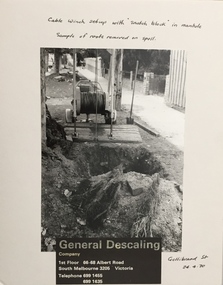
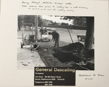
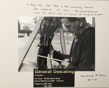
Photograph - Public Works Street Maintenance, Gellibrand Street, General Descaling, 1970
The series from which the photograph is drawn provides a snapshot by a commercial photographic studio of specific street works in Kew as well as providing examples of public works infrastructure being commissioned by local government in the 1970s. The photos originally formed part of the Engineering Department's files in the City of Kew before being donated to the Kew Historical Society.In addition to its historic importance as a record of a particular streetscape in Kew in 1970, the photograph also provides an historic record of public works by local government during the period.Public Works Street Maintenance, Gellibrand Street, Kew, Company supplied photograph of cable laying in Gellibrand Street. Inscribed above photo: "Boring through obstacles to pass cable. Cable extends from winch to cutting tool in both directions to permit a to and fro cutting motion. Gellibrand St. Drain 23.4.70." Company information: "General Descaling / Company / 1st Floor 66-68 Albert Road/ South Melbourne 3205 Victoria / Telephone 699 1455 / 699 1635."general descaling, drains, gellibrand street (kew) -
 Kew Historical Society Inc
Photograph - Public Works Street Maintenance, Gellibrand Street, General Descaling, 1970
The series from which the photograph is drawn provides a snapshot by a commercial photographic studio of specific street works in Kew as well as providing examples of public works infrastructure being commissioned by local government in the 1970s. The photos originally formed part of the Engineering Department's files in the City of Kew before being donated to the Kew Historical Society.In addition to its historic importance as a record of a particular streetscape in Kew in 1970, the photograph also provides an historic record of public works by local government during the period.Public Works Street Maintenance, Gellibrand Street, Kew. Company supplied photograph of cable laying in Gellibrand Street. Inscribed above photo: "Boring through obstacles to pass cable. Cable extends from winch to cutting tool in both directions to permit a to and fro cutting motion. Gellibrand St. Drain 23.4.70." Company information: "General Descaling / Company / 1st Floor 66-68 Albert Road/ South Melbourne 3205 Victoria / Telephone 699 1455 / 699 1635."general descaling, drains, gellibrand street (kew) -
 Victorian Interpretive Projects Inc.
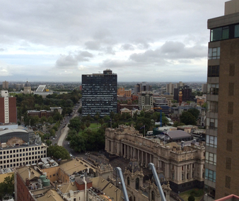
Photograph - Colour, Ann Gervasoni, Melbourne Towards Parliament House, 2015, 04/02/2015
Spring Street is culturally important to Victoria and is associated with the central spine of the administration of the Government of Victoria, as well as being central to many of the state's major cultural institutions. It is also notable for its Victorian architecture including the landmarks Victorian Parliament House, the Old Treasury Building, the Windsor Hotel (also known as Duchess of Spring Street) and the Princess Theatre. (Wikipedia)A colour photograph of Melbourne taken from above, showing Parliament House is Spring Street, with Russell Street in the midground. melbourne, spring street, victorian partliament house, windsor hotel, russell street -
 Federation University Historical Collection
Ephemera - Map, Webster Street Precinct, c2010
The Webster Street Precinct was actively mined during the 1850s. By the 1860s cottages had been built along the street and became fashionable.A small pamphlet outlining houses in Webster Street, Ballarat.webster street ballarat, architecture, peplow house, cairnhurst, roffensis, timeline, novar, glenholme, trerelffe, banyena, balderton, locksley, trelawne -
Whitehorse Historical Society Inc.
Map, Cadastral Map System, 2005
Land Victoria map of section of Blackburn North.Land Victoria map of section of Blackburn North, inc. Middleborough Road, Joseph Street and Chapman Street. Scale: 1:1500. With Lot Nos. and block frontage dimensions.Land Victoria map of section of Blackburn North. middleborough road, blackburn north, joseph street, blackburn north, chapman street, blackburn north -
 Kew Historical Society Inc
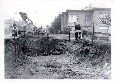
Photograph - Road works in the City of Kew, 1968-9
One of a series of photographs donated by the City Engineer of the former City of Kew, showing road works. The photos variably include council workers, signage and equipment.One of a series of photographs of core local government services as practised by the City of Kew. The photographs are an accurate record of street works of the period. Original black and white photographic positive of a road works in the former City of Kew. The photo shows an excavation in Studley Park Road near the corner of Carson Street in 1968/9. A Council officer and worker inspect the pit. Excavation equipment and a Council truck are at the back of the view. STUDLEY PARK ROAD AT CARSON STREET 1968/9city of kew, local government -- city of kew, road works, street works, kew city depot, studley park road -- kew (vic.) -
 Port Melbourne Historical & Preservation Society
Photograph - Launch of History of a Street Precinct, 25 Sep
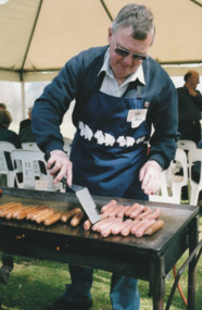
In 2005, members of the PMH&PS undertook a study of the residents of the houses in a Port Melbourne street precinct from the 1880s to 1960. The area is bounded by Evans Street, the E side of Bridge Street, S side of Williamstown Road, Farrell Street both the E & W sides plus the section of Ross Street between Farrell and Bridge and the part of Derham Street between Farrell and Bridge. The resulting map and an interactive CD won the Best Community Research, Registers & Records project at the 2007 Victorian Community History Awards. The project was launched on the railway reserve near the corner of Evans & Farrell streets. Jack BOLT is cooking with Ken TURNER in the background.Jack Bolt cooking sausages at the launch of the History of a Street Precinct25/9/05 Jack Bolt 11jack bolt, ken turner, history of a street precinct -
 Port Melbourne Historical & Preservation Society
Photograph - Launch of History of a Street Precinct, 25 Sep
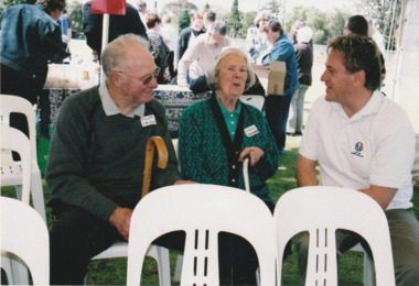
In 2005, members of the PMH&PS undertook a study of the residents of the houses in a Port Melbourne street precinct from the 1880s to 1960. The area is bounded by Evans Street, the E side of Bridge Street, S side of Williamstown Road, Farrell Street both the E & W sides plus the section of Ross Street between Farrell and Bridge and the part of Derham Street between Farrell and Bridge. The resulting map and an interactive CD won the Best Community Research, Registers & Records project at the 2007 Victorian Community History Awards. The project was launched on the railway reserve near the corner of Evans & Farrell streets. L - R - Unknown, Norah HOWARD, Mayor Darren RAY.CoPP mayor and PMHPS members at the launch of the History of a Street Precinct25/9/05 Not known, Norah Howard, Darren Ray, Mayorhistory of a street precinct, darren ray, norma howard -
 Port Melbourne Historical & Preservation Society
Photograph - Launch of History of a Street Precinct, 25 Sep
In 2005, members of the PMH&PS undertook a study of the residents of the houses in a Port Melbourne street precinct from the 1880s to 1960. The area is bounded by Evans Street, the E side of Bridge Street, S side of Williamstown Road, Farrell Street both the E & W sides plus the section of Ross Street between Farrell and Bridge and the part of Derham Street between Farrell and Bridge. The resulting map and an interactive CD won the Best Community Research, Registers & Records project at the 2007 Victorian Community History Awards. The project was launched on the railway reserve near the corner of Evans & Farrell streets. L - R - Unknown, Janet BOLITHO, Glen STUART.CoPP mayor and PMHPS members at the launch of the History of a Street Precinct25/9/05 Not known, Janet Bolitho, Glen Stuarthistory of a street precinct, janet bolitho, glen stuart -
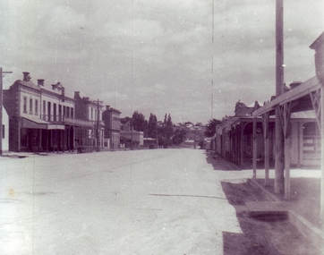 Clunes Museum
Photograph, C 1952
VIEW OF FRASER STREET, CLUNES.BLACK AND WHITE PHOTOGRAPH OF FRASER STREET, CLUNESlocal history, photography, photographs, clunes township -
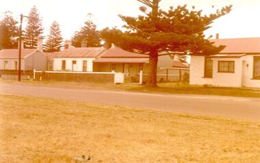 Port Fairy Historical Society Museum and Archives
Photograph
Campbell Street 26 to 30Coloured photograph of a row of houses in Campbell Streetcampbell street, houses, cottages, street -
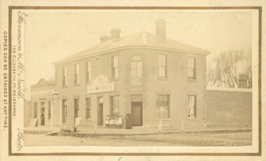 Bacchus Marsh & District Historical Society
Photograph, Royal Hotel corner of Main and Young Streets Bacchus Marsh 1883
This image is one of a series of photographs taken by Melbourne based photographers Stevenson and McNicoll who visited Bacchus Marsh nearby districts between September and November 1883. The Royal Hotel was built in 1861 and is located on the corner of Main and Young Streets in Bacchus Marsh. The first owner was James Murray and the hotel was first known as the Murray Family Hotel. James Murray died in an accident in 1863 and sometime after this the ownership passed to Richard Manning. From around 1869 it became known as the Royal Hotel. Richard Manning's son Frederick Manning inherited the hotel in 1896. The Manning family owned the hotel until sometime after 1945. In more recent decades it has been owned and operated by a number of different people. The hotel continues to operate as of 2024. This image shows the building in its original structure. In 1888, five years after this image was taken, a second storey was added to the section on Young Street. In this image this section is the single storey section of wall without windows to the right of the picture. Small sepia 'carte de viste' style unframed photograph on card with gold border framing photograph. Housed in the album, 'Photographs of Bacchus Marsh and District in 1883 by Stevenson and McNicoll'. The image shows the Royal Hotel seen from the intersection of Main and Young Streets. The diagonal view shows both the Main Street and Young Street sides of the building. It is a two storey brick building with a single storey brick extension on the Young Street frontage. Standing at the corner of the building is a woman and five girls. A deep gutter runs along the Main Street, with a pedestrian crossing ramp. Over this crossing point, there is a large metal frame bearing an ornate lantern. Next to it is a water trough for horses. Several hitching posts can be seen along the footpaths.Printed On the front: Stevenson & McNicoll. Photo. 108 Elizabeth St. Melbourne. COPIES CAN BE OBTAINED AT ANY TIME. On the back: LIGHT & TRUTH inscribed on a banner surmounted by a representation of the rising sun. Copies of this Portrait can be had at any time by sending the Name and Post Office Money Order or Stamps for the amount of order to STEVENSON & McNICOLL LATE BENSON & STEVENSON, Photographers. 108 Elizabeth Street, MELBOURNE. stevenson and mcnicoll 1883 photographs of bacchus marsh and district, hotels bacchus marsh, royal hotel bacchus marsh, manning family bacchus marsh, murray family hotel bacchus marsh -
Tatura Irrigation & Wartime Camps Museum
Photograph, McNamara's saleyards
Photograph looking west along Hogan Street, of Tatura's first saleyards, run by McNamara's.Black and white photograph of 's original saleyards, Tatura. Approx 1920.on back: McNamaras Hogan Street. Original saleyards.old saleyards, tatura -
Port Melbourne Historical & Preservation Society
Photograph - Back wall of Milk Bar in Princes Street from 70 Station Street, Port Melbourne, Pat Grainger
225 Princes Street was sold and demolished after its owner, Ted Young, was brutally murdered there (multiple stabbing). Police thought they knew who did it but had no evidence. Wall of Milk Bar across Princes Street was subsequently demolished.One of three colour photos of 225 Princes Street following demolition (2000?): .03 Higher view from 70 Station Street through to Princes Street and back wall of Milk Bar at Liardet and Princes before demolition.of the wallSome notes in pencilbuilt environment - domestic, demolitions, crimes and misdemeanours, edward (ted) young -
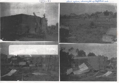 Rutherglen Historical Society
Image, c1953
Four black and white photographs, photocopied on a single piece of paper, showing damage in Murray street after mini cyclone 1952 or 1953. Written at top of page: "1952-53. Mini-cyclone. Murray Street up to Golf Club end."murray street, rutherglen golf club, weather damage, cyclone -
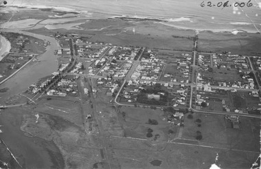 Port Fairy Historical Society Museum and Archives
Photograph, 1940's
The photograph depicts the river, bridge, rail line, Regent Street, Sackville Street, William Street and south west passage and pudney groundsSignificant for its depiction of the layout of the town in the 1940's and the river and south west passageBlack and white photograph Oblique Port Fairy Streets looking SouthALEX WILKINS PHOTOGRAPHER WARRNAMBOOL O.G.Powell Chemist Phone 88 Port Fairy Handwritten- Aerial View to be enlarged to 12" wide underlined 62.01.006 written on front of picturemoyne river, sackville street, william street, south west passage, pudney gorunds -
 Port Melbourne Historical & Preservation Society
Photograph - Launch of History of a Street Precinct, 25 Sep
In 2005, members of the PMH&PS undertook a study of the residents of the houses in a Port Melbourne street precinct from the 1880s to 1960. The area is bounded by Evans Street, the E side of Bridge Street, S side of Williamstown Road, Farrell Street both the E & W sides plus the section of Ross Street between Farrell and Bridge and the part of Derham Street between Farrell and Bridge. The resulting map and an interactive CD won the Best Community Research, Registers & Records project at the 2007 Victorian Community History Awards. The project was launched on the railway reserve near the corner of Evans & Farrell streets. Liana ThOMPSON is with her mother , Fay BATES/ SHAW nee DEVINE.Liana Thompson & Fay Bates the launch of the History of a Street Precinct. 25/9/05 Liana Thompson, Fay Bates (previously Shaw nee Devine)liana thompson, fay bates, history of a street precinct -
 Greensborough Historical Society
Folder, Banyule City Council, Main Street Greensborough, 2007-2011
Folder of coloured photographs of Main Street Greensborough, plus one aerial photograph of the area bounded by Grimshaw, Flintoff, Para and Main Streets and one of Grimshaw Street between Henry and Main Streets. Greensborough Shopping Centre prior to the construction of WatermarcGreen plastic folder of coloured photographic prints of Main Street Greensborough.main street greensborough, banyule city council, watermarc -
 Kew Historical Society Inc
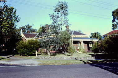
Slide - Villa, 16 Redmond Street, 1979
One of a group of slides taken by members of the Society of built heritage in Kew in 1979-80. The selection of subject matter reflects the priorities of the period. The colour of some slides has degraded.The slides represent a snapshot in time of built architecture in Kew, much of which has changed in the forty-plus period since they were created.Colour positive transparency (slide) of a single-storey Victorian tuck-pointed polychrome villa (formerly known as 'Roylands', 'Myrambeek') on the corner of Redmond and Fellows Streets, Kew. Research by Lovell Chen established that the house was built in 1892-3 and that owners have included Charles Bennett, Zilpah Bennett, Catherine Bucknall, Frederick Umber, George Darby etc. The 2014 report recommended that the house be included in the Schedule to the Heritage Overlay of the Boroondara Planning Scheme as an individually Significant place."Cnr Redmond and Fellows Streets"historic houses -- kew (vic.), victorian villas -- kew (vic.), 16 redmond street -- kew (vic.), roylands, myrambeek -
 Kew Historical Society Inc
Photograph - Public Works Street Maintenance, Gellibrand Street, General Descaling, 1970
The series from which the photograph is drawn provides a snapshot by a commercial photographic studio of specific street works in Kew as well as providing examples of public works infrastructure being commissioned by local government in the 1970s. The photos originally formed part of the Engineering Department's files in the City of Kew before being donated to the Kew Historical Society.In addition to its historic importance as a record of a particular streetscape in Kew in 1970, the photograph also provides an historic record of public works by local government during the period.Public Works Street Maintenance, Gellibrand Street, Kew, Company supplied photograph of measuring a tree root in Gellibrand Street. Inscribed above photo: "A tough dry root from a tree previously removed from alongside the drain. The root development inside the barrel had not caused the brick work to split. Gellibrand St. Drain 24.4.70." Company information: "General Descaling / Company / 1st Floor 66-68 Albert Road/ South Melbourne 3205 Victoria / Telephone 699 1455 / 699 1635."general descaling, drains, gellibrand street (kew) -
Bendigo Historical Society Inc.
Photograph - BABY PORTRAIT
Sepia photograph : baby portrait. Baby sitting on something covered in a fur rug, Baby wearing a white lacy dress with a large lace collar and a plain but dark coloured bow. Portrait by Steward & Co., 284 - 286 Bourke Street, Melbourne.Stewart & Co., 284-286 Bourke Street, Melbourne. Victoriaphotograph, portrait, baby, photograph, portrait, baby, photographer stewart & co. melbourne. -
 Hume City Civic Collection
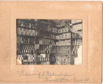
Photograph
Mounted b/w photograph of the interior of J. Gilchrist and Son, general store, Evans Street, Sunbury. (Shelves of goods for sale)Handwritten on front: interior of J. Gilchrist and Sons' General Store, Evans Street Handwritten on back: H. Gilchristj. gilchrist and son, general store, business, gilchrist, h., george evans collection -
 City of Kingston
Pamphlet - Colour, Fergusson & Mitchell Lith, Sandringham Rises, c. 1888
Sales plan for land in the suburb of Sandringham, bounded by Bluff Road, Bay Road and William Street, and incorporating Frances Street.The developing urban area of Highett (then called Sandringham) within the City of Kingston. This land sale pamphlet illustrates the subdivision of land within the municipality and the changing demographic of the district as new houses are constructed close to infrastructure.Colour pamphlet advertising for sale 35 lots in Sandringham Rises, Sandringham. Incorporates a map of the estate bordered by Bluff Road, Bay Road and William Street, including Frances Street.Handwritten in grey pencil next to the words 'THREE O'CLOCK': 1888 Handwritten in blue ben next to the words '& BUSINESS SITES': 1888land sales, sandringham, highett -
 Stawell Historical Society Inc
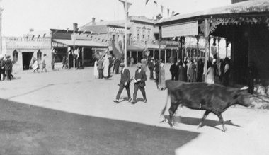
Photograph, Main Street Stawell corner of Wimmera Street with Stabbs Coach Building visable c1920's, 1920
Sepia photo of Stawell Main Street Scene. Stabb's Coach Building on corner of Wimmera Street visible. C1920's. Possibly Easter bunting hanging in the street.Sepia Photograph of a scene in a commercial area. People in the Street. A Cow in the foreground. Stawell from the side of the P.O. (Nell Kingston)stawell