Showing 10386 items
matching plan
-
 Whitehorse Historical Society Inc.
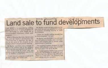
Article, Land sale to fund developments, 19/10/1994 12:00:00 AM
RSPCA plans to sell 5 or 6 acres of its East Burwood property at market value to help fund the new veterinary clinic and hospital.Newspaper article outlining RSPCA plans to sell 5 or 6 acres of its East Burwood property at market value to help fund the new veterinary clinic and hospital. The sum required to build the new hospital and clinic is $4 million. RSPCA plans to sell 5 or 6 acres of its East Burwood property at market value to help fund the new veterinary clinic and hospital. royal society for the prevention of cruelty to animals, burwood east, barber, peter, veterinary services, land sales -
 Whitehorse Historical Society Inc.
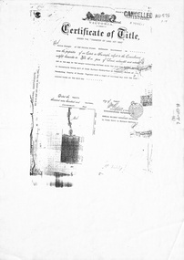
Legal record - Document, Forest Hill, 12/08/1913
Photocopy of Certificate of Title. Vol 3715 Fol. 742903 to Julius Draeger, 12 August 1913, for fifteen acres of land being part of Crown Portion 94, including plan of subdivision (P72294) cancelling title. [Contract of Sale ND567]Photocopy of Certificate of Title. Vol 3715 Fol. 742903 to Julius Draeger, 12 August 1913, for fifteen acres of land being part of Crown Portion 94, including plan of subdivision (P72294) cancelling title. [Contract of Sale ND567]Photocopy of Certificate of Title. Vol 3715 Fol. 742903 to Julius Draeger, 12 August 1913, for fifteen acres of land being part of Crown Portion 94, including plan of subdivision (P72294) cancelling title. [Contract of Sale ND567]glebe street, forest hill, land subdivision, draeger, carl julius otto, vicki street, bindy street, lee-ann street -
 Whitehorse Historical Society Inc.
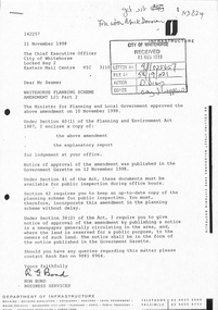
Document - Planning Scheme Amendment, Former Town Hall, 1/11/1998
Whitehorse Planning Scheme amendment L21, Part 2 with explanatory report and covering latter from Department of Infrastructure to City of Whitehorse regarding changed requirements affecting former town hall building, 360 - 362 Whitehorse Road, Nunawading.city of whitehorse, victoria. department of infrastructure, whitehorse road, nunawading, no 360, municipal chambers, city of nunawading, whitehorse planning scheme, shire of blackburn and mitcham -
 Lakes Entrance Regional Historical Society (operating as Lakes Entrance History Centre & Museum)
Photograph, Lakes Post Newspaper, 1990
number in album 03535.02Black and white photograph Mary Daly Manager of Whiters Holiday Village showing Senior Citizens Vi and Larnie Petersen and seven others where swimming pool will be built during visit to learn of the new plans, . Lakes Entrance Victoriarecreational facilities, fundraising -
 Ballarat Tramway Museum
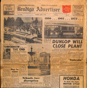
Newspaper, Bendigo Advertiser, "Tomorrow the End", 15/04/1972 12:00:00 AM
Newspaper clipping from The Bendigo Advertiser 15/4/1972, titled "Tomorrow the End" reporting on the closure the following day of the Bendigo tramway system, Has a short history of the tramway and three photos of trams in Bendigo and the plans for the following day.closure, bendigo, sec -
 Bendigo Historical Society Inc.
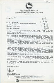
Document - Bendigo Chamber of Commerce letter from the Victorian State Chamber of commerce re re-structure, 1989
The Bendigo Chamber of Commerce and Industry was constituted in 1886 with the vision to be the single voice for the business community across greater Bendigo. ‘Be.Bendigo’ is the trading name of the organisation ‘Bendigo Business Council’ which was formed in 2008 as a merger between two Bendigo business organisations: The Bendigo Chamber of Commerce and Central Victorian Business Network (CVBN). Upon the merger, Bendigo Business Council continued the functions of both the Chamber and CVBN by providing advocacy, networking and events to members and partners.Bendigo Chamber of Commerce letter from the Victorian State Chamber of commerce re re-structure. Dated 28 April 1989. Numerous printed pages outlining the plan of action for forming an independent Chamber of Commerce in Bendigo and developing a constitution.history, bendigo, bendigo chamber of commerce collection -
 Bendigo Historical Society Inc.
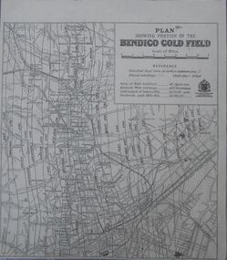
Map - Bendigo Gold Field
Plan showing portion of the Bendigo goldfield. Area of main goldfield: 140 square miles. Deepest mine working: 4593' (Victoria quartz). Gold output of field to 1935: 20,775,000 ounces. Dividends paid 1870-1935: 10,740,000 pounds.map, goldfield, bendigo -
 Ballarat Tramway Museum
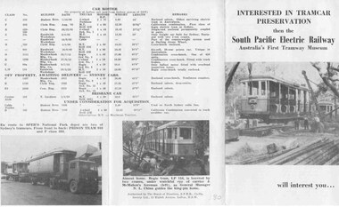
Pamphlet, South Pacific Electric Railway, SPER - invitation and information, 1960
A folder pamphlet inviting inspection and participation to South Pacific Electric Railway Museum at National Park - 4 photos, outlining future plans, etc. folds into 3 portions - gives list of trams held at the time - early 60's.trams, tramways, tramway museums, sydney, tramcars, preservation -
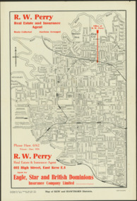 Kew Historical Society Inc
Map - Map of Kew and Hawthorn Districts
Map of Kew, East Kew and Hawthorn produced for a Kew Real Estate Agent, RW Perry. The map is undated.Two-colour map of Kew and Hawthorn Districts produced for by R.L. Jarrett for RW Perry, Real Estate & Insurance Agent. The map has unusual features such as a planned railway link from Kew Station to the former Outer Circle Railway. RW Perry / Real Estate & Insurance Agent, 602 High Street, East Kewmaps - kew (vic), maps - hawthorn (vic), r.w. perry, real estate agents -- kew (vic.) -
 Canterbury History Group
Ephemera - 5 Monomeath Avenue Canterbury, [2004]
Real estate advertisement for the sale by auction of "Langley" 5 Monomeath Avenue Canterbury c1936 on Saturday 15 May {2004].Includes coloured photographs of the interior and exterior of the house and floor and site plans. Includes a covering letter from the agents.canterbury, monomeath avenue, langley, mcilwraith family, golden mile, stairs, swimming pools, tennis courts -
Canterbury History Group
Ephemera - Realisation auction 200a Canterbury Road Canterbury, 1/05/2003 12:00:00 AM
Two copies of the real estate advertisement for the auction of 200a Canterbury Road, Canterbury on Wednesday 7 May 2003.Incudes a coloured photograph of the exterior of the shop and floor plan. Both have notes on the back by Robin Kelly of the result of the auction.canterbury, canterbury road, canterbury railway station, fish shops, shops -
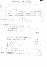 Falls Creek Historical Society
Document - Motel Planning - Hand-Written - Profit Estimate - Full Year Of Operation, 30.04.1963
Bob (Herman) Hymans (a former member of the Royal Netherlands Navy) was born in Bloemendaal, Holland on 30th September 1922. During World War II he fought against the Japanese in the Dutch East Indies (now Indonesia) and was imprisoned in Changi and on the Burma Railway. After gaining qualifications as a Ski Instructor, Bob arrived in Falls Creek in July 1950. Working as an Instructor and Supervisor at Bogong Lodge, Bob decided his future was in accommodation. He was successful in negotiating an indenture for land from the State Electricity Commission (SEC). It took Bob two years to build his Grand Coeur Chalet but, tragically, it was burned down in August 1961. Bob also built the first Chairlift in Australia. This was a single chairlift and the structure was built from wooden electricity poles. He was constantly full of new ideas and proposals for the village. Bob Hymans die on 7th July 2007. This Collection of documents and letters tells the story of Bob's endeavours to develop Falls Creek into the ski village it is today.This Collection of documents and letters tells the story of Bob’s endeavours to develop Falls Creek into the ski village it is today. This document is a detailed profit and loss estimate written by Mr Hymans in planning for establishment of a new motel in Falls Creek. All calculations are hand written and carefully divided into different sections. It also included a detailed staff allocation for one year.falls creek tourist area management committee, bob hymans, falls creek administration -
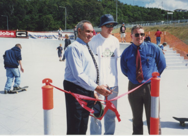 Lakes Entrance Regional Historical Society (operating as Lakes Entrance History Centre & Museum)
Photograph, Lakes Post Newspaper, 2000
number in album 03587.01Colour photograph cutting ribbon at the Opening Ceremony of the Skateboard Park, Cr Ron Schrader Deputy Mayor, Aaron Stroud of Skatepark Planning Committee and Chris Walker Resource Services from E G Shire. Lakes Entrance Victoriasports, construction -
 Bacchus Marsh & District Historical Society
Map, Township of Maddingley, Parish of Parwan, County of Grant
This map is dated Sept. 6th 1856. However places in the township of Maddingley which did not appear until the late 1880s such as the Bacchus Marsh Railway Station and line are shown on this map in their correct locations. This suggests the map has been derived from an earlier map. An earlier date of 1843 with a surveyor's name preceding it can also be seen on the map. The map is important because it indicates the location and dimensions of early but now discontinued use of land such as the showgrounds and police paddock and a site reserved for the Church of England which was not ultimately used for a permanent church. A single page paper map showing land allotments, streets, rivers, creeks, park lands, the railway line and Bacchus Marsh railway station in the township of Maddingley. The map is pasted into a bound volume containing 76 maps or plans in total. Bottom of Map: Surveyor-General's Office, Melbourne, Sept 6th, 1856bacchus marsh victoria maps, maddingley victoria maps, land use, maddingley victoria history -
Canterbury History Group
Ephemera - A charming period house in a prime position, 1998
Real estate advertisement for the auction on 15 August 1998 of 44 Balwyn Road Canterbury. Includes coloured photographs of the interior and exterior of the house and floor and site plans. Includes note by Robin Kelly of purchase price $450, 000 approx.canterbury, balwyn road, californian bungalows -
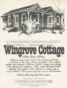 Eltham District Historical Society Inc
Document - Property Binder, 672 Main Road, Eltham
Flyer, Neville Emerson Pty Ltd, for sale Wingrove Cottage. Shire of Eltham Heritage Study, nd but post 1989: Wingrove Cottage. Note: June 1997 re Judy David, descendant of Mr Wingrove. Note: 2 September 2003: Greg Johnson description of building. Statement 2 September 2003 from Francis Percival (Jock) Read of memories of Wingrove Cottage. Copy letter 21 October 2002 from Value Creating Environments (recent purchasers of Wingrove site) to John Karageorge Planning and Building Services Nillumbik Shire re planned work; also attachment re possible site development. Newspaper article: Diamond Valley Leader, 23 October 2002, Angry crowd stops demolition, photograph of part demolition. Letter 30 December 2002 from Stephen Coleriro Acting Manager Planning and Building Services Nillumbik Shire re consultation on illegal demolition works at Wingrove Cottage. Letter 24 February 2003 from Allom Lovell & Associates to John Karageorge Shire of Nillumbik commenting on Wingrove Cottage work. Newspaper article: Diamond Valley Leader, 17 September 2003, Court orders restoration at cottage. Newspaper article: Diamond Valley Leader, 25 February 2004, Health vision for Eltham's 1800s home, Wingrove Cottage will be restored as health and wellness centre if plans approved. Newspaper article: Diamond Valley Leader, 7 July 2004, 1850s bricks in debris, Jim Cummane owner ordered to prepare conservation plan, photograph of site and Harry Gilham president Eltham District Historical Society. Newspaper article: Diamond Valley Leader, 1 December 2004, Cottage heritage plan crucial to sale success, site to be sold, photograph of Wingrove Cottage. Letter 14 April 2005 from Gaye Van Donkelaar Planning and Building Services Nillumbik Shire to Russell Yeoman Eltham District Historical Society re meeting of key stakeholders 27 April 2005. Newspaper article: Diamond Valley Leader, 28 March 2007, Cottage work on hold, recent purchasers Cameron Construction restored Cottage, open as photographic studio, applied for permit to build office and 7 homes on site. Letter 13 August 2007 from Senior Registrar VCAt to Eltham District Historical Society enclosing VCAT order re application for 672 Main Road. Letter 24 August 2007 from Colin Bowden Planning and Development Consultants to VCAT enclosing response prepared by O'Brien Traffic for VCAT. Letter 14 February 2007 from Jeremy Livingstone Planning and Building Services Nillumbik Shire, invitation to review re planning application.main road, eltham, property, houses, wingrove cottage -
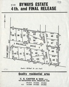 Ringwood and District Historical Society
Flyer, Land Sale Brochure, Byways Estate Ringwood East - 4th and Final Release - 1970
Refer also to Reg. No. 5110 for Byways Estate 1965 release, and Reg. No. 5113 for Byways Estate 1967 release.Single page advertisement showing layout of the last stage of the Byways Estate subdivisionSubdivision plan includes Hume Street, Walhalla Drive and Hender Street. (Agent) C.E. Carter & Son R.E.S.I. 126 Whitehorse Road, Ringwood, 3134 (Telephone) 870 2519, 870 6830, 870 6024, A.H. 723 3298, 870 4604, 870 6454 -
 Ringwood and District Historical Society
Flyer, Executor's Auction Subdivision Advertisement, Lilydale Road and Oban Road, Ringwood East, Vic. - 1937
Single page advertisement for Executor's Auction of land in Ringwood East on Saturday, May 29, 1937 with locality map showing 26 building sites for auction highlighted in brown, and brief summary of local services available. Subdivision includes Old Lilydale Road, Joseph Street, Dynes Street, Albert Street (later Wyrunga Street), Carcoola Road, and Mount Dandeong Road. (Carcoola Road incorrectly shown as Oban Road on the subdivision plan). Auctioneer - C.E. Carter, (Phone Ringwood 24. -
 Ringwood and District Historical Society
Flyer, Land Sale Advertisement - State School Estate, Ringwood, Victoria - 1923
The date of the flyer as circa 1920 can be estimated from the references to the (decision on) "electrification of the Croydon Railway Line" which eventually occurred in 1923, letting of tenders for the state school building which opened in 1924, and the "proposed new railway station" (East Ringwood) which opened in 1925, Advertisement for State School Estate, Ringwood - 26 residential allotments for sale near East Ringwood State School development site and 7 minutes walk from proposed new railway station (East Ringwood). Includes location map and terms of sale.Locality plan includes King Street and Government Roads (Later Everard Road, Holland Road, Purser Avenue, and Charles Street). (Agents) J.B. McAlpin, Estate Agent and Subdivisional Manager, Ringwood (Opposite Station), and F.V. Parker, Estate Agent, Main Street, Ringwood. -
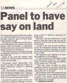 Ringwood and District Historical Society
Newspaper, Scrapbook Clipping, Library Collection, Ringwood, Victoria
Newspaper Clipping from "The Mail", 3-10-95. P23. By Andrew Meath. Panel to have Say on LandAn independent panel will decide whether a housing subdivision in an environmentally sensitive part of North Ringwood should proceed. The Ministry of Planning and Development will appoint the panel to consider a request from developers of Barnsdale Forest to divide one acre (0.4 hectares) parcels of land into 7 lots -
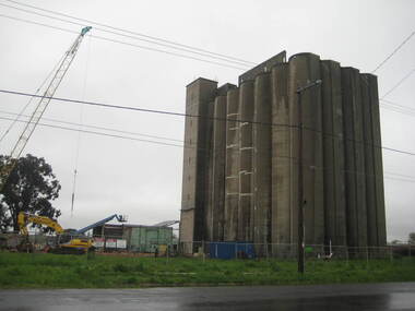 Ballarat Heritage Services
Photograph - Photograph - Colour, Lisa Gervasoni, Joe White Maltings Silos Under Demolition, 2010, 15/10/2010
"A plan to turn the Gregory Street silos into apartments is no more.Developers Eleveno Pty Ltd have abandoned plans to transform the Lake Wendouree silos into a giant apartment complex, despite previously being given the green light from the Victorian Civil and Administrative Tribunal.Director Richard Sykes yesterday confirmed the silos would be demolished."The plans are not proceeding. The plan now is to create residential houses," he said.The planning permit for an 18-lot subdivision was approved by Ballarat City Council on July 22, despite objections lodged against the application.Mr Sykes said it wasn't feasible to turn the silos into 27 units and there were many factors behind the decision."They're being demolished for various reasons, there were just better solutions," he said.Bold plans to transform the former Joe White Maltings silos into apartments were first submitted to Ballarat City Council in January 2007.However, developers took the proposal to VCAT in September 2008 after council failed to make a decision in the required 60-day timeframe.A hearing was held in early 2009 and the development was approved in March last year.Mr Sykes said it was found that the building would most likely be out of place in the region."We found the market didn't really want that sort of development," he said."They're probably more suited for inner-city development, rather than regional areas."Mr Sykes did not put a price on either the proposed development or the demolition, but said it would "cost a fair amount of money".He said once the demolition permit has been passed, works were expected to begin in November." (Ballarat Courier, 03 August 2010)Joe White Maltings Silos in Gregory Street Ballarat under demolition, to make way for a housing development. The silos were built on the banks of Lake Wendouree. joe white maltings, silo, eleveno pty ltd, lake wendouree, demolition, gregory street ballarat, wendouree parade, architecture -
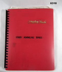 Bendigo Military Museum
Administrative record - Army Survey Regiment Officers Mess Ball 1989, Army Survey Regiment, 25 Feb 1989
The Army Survey Regiment held Annual Balls at Fortuna Villa. This folder contains the documentation for the Logistics and activities associated with the planning and running of the Ball in 1989.A4 Plastic bound Red Display Folder containing documentation for the 1989 Annual Ball, Letters, signals and photosroyal australian survey corps, rasvy, fortuna, army survey regiment, army svy regt, asr -
 Greensborough Historical Society
Newspaper Clipping, Diamond Valley Leader, Safety concerns, 18/07/2018
A planning application for a double storey childcare and medical centre to be built at the intersection of Grimshaw Street and Macorna Street has left the community seeing red.News article 1 page, black text.childcare centre, watsonia north, grimshaw street watsonia, macorna street watsonia -
 Greensborough Historical Society
Newspaper Clipping, Diamond Valley Leader, VicRoads under fire as 3600 trees face the axe for road widening, 31/05/2017
A Yan Yean Rd community forum member is concerned VicRoads is not being transparent about the removal of 3600 trees as part of plans for the road’s realignment.News article 1 page, black text.yan yean road, vicroads, tree removal, yarrambat -
 Tatura Irrigation & Wartime Camps Museum
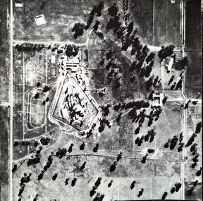
Photograph, Aerial Photograph Dhurringile Mansion, 1940
Dhurringile POW camp aerial photograph. Obtain May 1989 from the Historic Photographs Department, Treasury Place, Melbourne (Central Planning Office). Black and white photograph. Aerial photo of Dhurringile Camp and surrounding area. North is at top of picture.dhurringile pow camp, dhurringile aerial photo -
 Creswick Campus Historical Collection - University of Melbourne
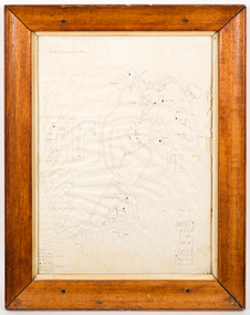
Map - Campus map, framed, 1969-1974
VSF Fire protection Plan. Framed. Prepared in interval between construction of Science Block and commencement of Certificate Courses (1969-1974) (Bob Orr)Mapfire protection, victorian school of forestry, creswick -
National Wool Museum
Calendar, Planned Flock Management: 1984 Calendar
"Planned Flock Management: 1984 Calendar". Produced to assist wool growers in working out when to vaccinate their flock, when to allow lambing, etc.wool growing sheep breeding, victoria; department of agriculture, wool growing, sheep breeding -
8th/13th Victorian Mounted Rifles Regimental Collection
Document - VMR Centenary activities
Parades were planned for Albury, Wodonga, Wangaratta, Benalla and Cobram; A special postage stamp was issued. A Church parade and an Regimental Ball were held.Typed media release relating to Centenary activities of Victorian Mounted Rifles dated 23 April 1985. One page.military, centenary, vmr -
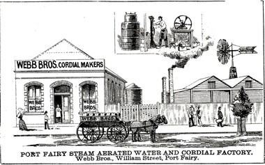 Port Fairy Historical Society Museum and Archives
Drawing - large picture, Webb Bros Cordial Factory
This lithograph shows William Webb's Cordial and Aerated Waters factory on William Street. An 1887 plan shows three buildings forming part of the factory. Black & white etching of Large building of Webb Bros Cordial factory with delivery cart out front and lower wooden buildings to the leftPort Fairy Steam Aerated Water and Cordial Factory Webb Bros. William Street Port Fairyfactory, business, shop -
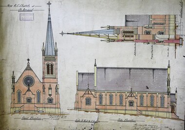 Ballarat Diocesan Historical Commission
Architectural plans, Architectural plans for R.C.Church St Arnaud
Plans drawn up by architects Keogh and Austin of Bendigo in 1906 for the Catholic church St Arnaud. The church was completed without its tower and spire. st arnaud, catholic church, architectural plan.