Showing 55878 items
matching documents-maps
-
 Ringwood and District Historical Society
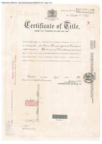
Document, Certificate of Title - W.G. Carter, Grandview Grove, Warranwood, Victoria, (later Bemboka Road) - part of Crown Section Twenty, Parish of Warrandyte, County of Evelyn - 1947
A4 copies of Landata Victoria Historical Search documents - Vol 7052 Fol 1410222. Includes Carter Family Tree property notes. William George Carter of Grandview Grove Ringwood, Nurseryman, is now the proprietor - three acres or thereabouts shown on map (12202a) - 14th March, 1947. Transfer B284834 Registered 21 September, 1961 - 1 acre shown on map (12202c) north of Plymouth Road. NOTES ON GRANDVIEW GROVE PROPERTY (Carter Family Tree extract) The Grandview Grove property was purchased by William (Bill) and Doreen Carter in 1947 as three acres of uncleared bushland. They had a 2 bedroom fibro-cement house built on the land which they informally called "Willoreen". With Doreen looking after sons Peter (born in 1940) and Robin (born in 1950), Bill worked locally at Croydon Dairy. The family spent much of their spare time clearing the land, where Bill then grew and sold fruit, flowers and berries, particularly strawberries, as a hobby and to supplement their income. Bill continued to do so while Peter and Robin were growing up, and after Doreen died in 1958. In 1961 Bill sold one of the three acres to one of his seven sisters, Grace, who lived in Kew but later moved to Rosebud and sold the land without ever building on it. During the 1960s, Grandview Grove was renamed Bemboka Road. After retiring as a milkman, Bill moved to Rosebud, Vic, and in 1977, sold the property to the Anglican Church, who were looking to invest in the site in anticipation of proposed future residential development in the area. As nearby properties were subdivided during the 1980s, the house, which the Church had initially utilised as low-cost family accommodation, was modified internaly to become a church/Sunday school. By the early 2000s, construction of a contemporary-design church and carparking area between the house and street alignment had been completed but the house remained as a detatched meeting room until falling into disrepair and was eventually demolished around 2010. -
 Bendigo Military Museum
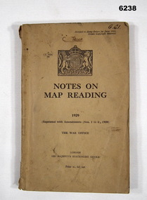
Manual - Notes on Map Reading 1929 - The War Office, 30.06.1939
Instruction in Map reading. The object of map - reading is to tender possible the clear and accurate visualization of the ground from a map productBrown Cardboard book, A5 Size, Several insets. Reprinted with Amendments 1-4 1939, 95 pages.royal australian survey corps, rasvy, fortuna, army survey regiment, army svy regt, asr -
 Warrnambool and District Historical Society Inc.
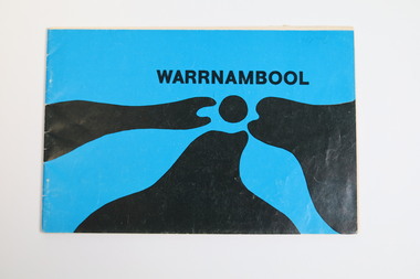
Booklet - Tourist booklet, Warrnambool Chamber of Commerce and Industry, Warrnambool, c. 1970
Warrnambool Tourist BookletThis is a booklet of 30 pages with a blue and black cover featuring an art work, a map, advertisements, black and white photographs and printed text. The booklet was stapled but the staples have been removed.non-fictionWarrnambool Tourist Bookletwarrnambool tourism, warrnambool tourist guides, warrnambool chamber of commerc -
 Bendigo Historical Society Inc.
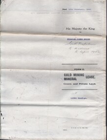
Document - MCCOLL, RANKIN AND STANISTREET COLLECTION: NAPOLEON REEF GOLD MINING CO. N.L, 18 Feb 1941
Document: 4 Page legal document with map of lease area issued to William James Moore of Bendigo, Lease No. 11064 Bendigo, Vol. 325 Fol. 35881 County of Bendigo Parish of Sandhurst, 15 year lease from 18th February 1941, in vacinity of Curnow St, Booth St, Maple St and Rowan Sts, Lease by South Napoleon to be allowed to lapse in 1942, signed by Major General Sir Winston Joseph Dugan Governor of Victoria, William James Moore & witnessed by Walsh, Wardens Clerk Bendigo.organization, business, industrial - mining, mccoll rankin & stanistreet, mining, gold mining, napoleon reef -
 Warrnambool and District Historical Society Inc.
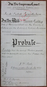
Document - Thomas Oakley Letters of Administration 1898, 1893
Tait collection: item 39 of 62 This document gives the details of the Will and Probate of Thomas Oakley who died in Warrnambool at the age of 75 in 1893. He had come with his first wife to Australia in 1852 and was a Customs Officer in Warrnambool, in charge of the signals and premises, living in Merri Street. Later after the death of his wife (they had ten children) he married Eliza McKeeman in 1870 and they lived at ‘Oakbank’ near the Warrnambool Cemetery where Oakley pursued farming interests. They had a further eight children, many of them making their mark in the business and community life of Warrnambool and further afield. Thomas Oakley left real estate to the value of £900 and personal estate to the value of £1251, with the beneficiaries being his wife, his daughters, Elizabeth and Mary Anne from his first marriage and the eight children of his second marriage. The lawyers concerned with this document, O’Mahony and Murray, had offices in Warrnambool in Kepler Street at the end of the 19th century and the beginning of the 20th century. This document was in the possession of Ernest Chambers, a Warrnambool lawyer during the same period. It was then passed down to successive lawyers occupying the Kepler Street premises and located there in 2014.This document is of considerable importance as it gives details of the Will and Probate of Thomas Oakley, a prominent and successful landowner in Warrnambool in the 19th century. It will be of great use to researchers. This is a white piece of thick paper folded in two with handwritten material on four sides of the paper. The pages have printed red lines at the edges of three pages. The document contains details of the Will and Probate of Thomas Oakley who died in 1893 in Warrnambool. The pages are clean and readable.In the Supreme Court of the Colony of Victoria in its Probate Jurisdiction in the Will of Thomas Oakley late of Warrnambool in the County of Villiers in the Colony of Victoria Landowner deceased.o’mahony & murray,, warrnambool lawyers, ernest chambers, warrnambool lawyer, thomas oakley, tait collection -
 Bendigo Historical Society Inc.
Map - CAMPBELL COLLECTION: BENDIGO AND DISTRICT MAPS
Map. Two aerial photographs of Kangaroo Flat and Lockwood (part). Crusoe Reservoir bottom right corner on Crusoe Road, shows Merindah Road running between Lockwood and Crusoe Roads. Map Name : Bendigo Mapsheet Run 2. 14-2-71, 13,200 A.S.L.. Map shown with NORTH at bottom of page, VIC 2479 at corner. Map 2 continues to the west. A joined copy of both maps is also included.map, bendigo, agricultural lands -
 Bendigo Historical Society Inc.
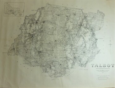
Map - JACK FLYNN COLLECTION: TALBOT, 1937
Map: County of Talbot, map sheet showing the whole of the County of Talbot and all of the Parishes within. Scale 2 Miles to 1 inch.By Authority: A.C. Brooks, Government Printer, Melbourne. Department of Lands and Survey Melbourne. 1959map, talbot, county, talbot -
Bendigo Historical Society Inc.
Map - PARISH OF HUNTLY(PART) AND SANDHURST(PART), No date visible
Map: Part of parish plan of Bendigo, covering Strathdale, White Hills, Huntly and North Bendigo ( number 144 in Map Cupboard 1)map, bendigo, city streets, parish of hunlty, parish of sandhurst, strathdale, white hills, huntly, north bendigo -
Bendigo Historical Society Inc.
Map - PORTION OF ELMORE ESTATE, 19/10/1920
Map: Portion of Elmore Estate, Parish of Egerton, County of Bendigo. Parish plan Canvas backed ( number 135 in Map Cupboard 1)map, bendigo, rural, elmore estate, egerton, county of bendigo -
Bendigo Historical Society Inc.
Map - PORTION OF ELMORE ESTATE, 19/10/1920
Map: Portion of Elmore Estate, Parish of Minto, County of Bendigo. Parish plan Canvas backed ( number 131 in Map Cupboard 1)map, bendigo, rural, elmore estate, minto, county of bendigo -
Bendigo Historical Society Inc.
Map - SANDHURST (PART), No date Visible
Map: Hand Draughted parish plan showing the area North and East of Spring Gully Reservoir ( number 206 in Map Cupboard 1)map, bendigo, parish plan, parish of sandhurst, spring gully -
Bendigo Historical Society Inc.
Map - DINGEE SUBDIVISION, 25/11/1913
Map: Dingee Subdivision, Parishes of Talambe and Yallook, County of Bendigo, Parish Plan, Canvas Backed ( number 128 in Map Cupboard 1)map, bendigo, rural, dingee subdivision, talambe, yallook, county of bendigo -
Bendigo Historical Society Inc.
Map - RESURVEY PARISH OF SANDHURST, 23/07/1891
Map: Resurvey, Parish of Sandhhurst sheet No. IV, Enlargement of part of sheet No. III. Parish plan ( number 204 in Map Cupboard 1)map, bendigo, parish plan, parish of sandhurst, resurvey -
Bendigo Historical Society Inc.
Map - RODNEY, No date visible
Map: Rodney, plan of the whole County of Rodney showing reserves under the Forest Act 1907 (number 257 in map cupboard 1)map, rodney, reserves, rodney, forest act 1907, reserves -
Bendigo Historical Society Inc.
Map - PARISH OF MARONG, 24/09/1874
Map; Parish of Marong ,County of Bendigo. This plan has been cut and then applied to a different backing. ( number 234 in Map Cupboard 1)map, bendigo, parish plan, marong -
Bendigo Historical Society Inc.
Map - COUNTRY LANDS, 4/06/1874
Map: Country lands, Parishes of Goornong, Egerton, Elmore and Nolan, County of Bendigo. Parish plan (number 298 in map cupboard 1)map, bendigo, country lands, country lands, goornong, elmore, egerton, nolan -
Bendigo Historical Society Inc.
Map - AVAILABLE ALLOTMENTS, 10/08/1908
map: Available Allotments, Parishes of Whirrakee, Bagshot and Egerton, County of Bendigo. Parish plan (coloured) (number 330 in map cupboard 1)map, bendigo, allotments, available allotments, whirrakee, bagshot, egerton -
Bendigo Historical Society Inc.
Map - BENDIGO GOLDFIELD, No date visible
Map: Bendigo Goldfield. Scale 20 chains to 1 inch. Printed by Cambridge Press, Bendigo. (number 318 in map cupboard 1)map, bendigo, mining plan, bendigo goldfield, gold mines, mining -
 National Vietnam Veterans Museum (NVVM)
Map, Relief Map of Vietnam
Detailed relief map with words XA BIN BA + XUYEN MOC titled on information heading. Map information listed on lower portion.relief map, vietnam -
 Tatura Irrigation & Wartime Camps Museum
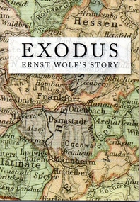
Book, Exodus. Ernst Wolf's story, 2012
Author Ernst Wolf was an internee who arrived in Australia aboard the Dunera. 68 pages, B&W and colour photos. Soft cover with a map of Germany superimposed on cover. Map of Victoria superimposed on back cover.Celebrating the 90th birthday of Ernst Wolfe, December 30th, 2011, and for the Wolfe family everywheredunera, ernst wolf, exodus -
Tatura Irrigation & Wartime Camps Museum
Pamphlet, Community in Action, 1993
Annual report 1992/93 Salinity program Advisory Council. Includes names of action groupsSalanity testing photos on front. Orange cover. Vic. map in green, Murray Darling Basin map on back. Community Group photossalinity, books, reports, irrigation -
Bendigo Historical Society Inc.
Map - BENDIGO GOLD FIELDS
Map, Bendigo Gold Fields, copy, mining leases, the numbers of their leases, as well as streets of Bendigo.( number 408 in Map Cupboard 1).bendigo, mining, mining leases -
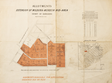 Merbein District Historical Society
Map - Allotments Extension of Mildura-Merbein Mid-Area, Allotments available, 23 November 1920
Allotments available to Discharged Soldiers Discharged Soldier's Settlement Act Historic Large map, folded in 4, coloured map of Merbein indicating allotments available and locality plan. Scale 10 chain to 1 inchPhoto-Lithographed at Department of lands Survey, Melbourne J. Butson 23.11.20discharged soldiers, ww1, soldier settlement, irrigation -
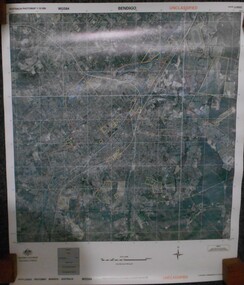 Bendigo Historical Society Inc.
Map - BENDIGO AERIAL MAP 2007
Aerial map of Bendigo 2007 printed on vinyl. Written on bottom of map ' Australian Government Department of Defence photomap Bendigo Australia WGS84.aerial photo, bendigo map -
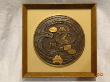 Learmonth and District Historical Society Inc.
Plaque "ANA"100 years service to Australia, Circa 20th century
CENTENARY PLAQUE AUSTRALIAN NATIVES ASSOCIATION.1871 - 1971.This plaque commemorates the centenary of the Australian Natives Association and depicts some of the achievements brought about by the Association in Australia over a Century.The circular shape symbolizes a continuous line of achievements around a central point or theme.Whithin this shape are three bands of waving and undulating sand textured steps,passing through the map of Australia. these bands signify the rolling sandy plains which are so characteristic of this country .There is a total of seven basic shapes representing the seven states - six of which are overlapping representing the mainland.The six oval shapes depict The ANA.crest Federation 1901.The Made in Australia Council.The Australia Day Council. The Armed Forces and Friendly Society.Made to commemorate 100 years service of ANA to Australia.A rectangular shadow box style frame of brown wood,in which is a round Brass Medallion on a beige background.Around the edge are wavy bands representing rolling sands.At the top are the words AUSTRALIAN NATIVES ASSOCIATION and at the bottom is inscribed 100 YEARS OF SERVICE and on a map of Australia TO AUSTRALIA.There are seven basic oval shapes on which -from the top-is the ANA Crest and the words Federation 1901.then a Boomerang with the stars of the Southern Cross and the words Buy Australian,then a map of Australia on which are standing three figures of Army,Navy,Airforce Personel,then the Australian flag with Jan 26 and Friendly Society.AUSTRALIAN NATIVES ASSOCIATION 100 YEARS OF SERVICE TO AUSTRALIA.ana commemoration plaque. -
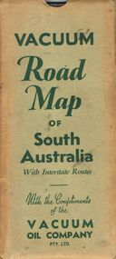 Bendigo Historical Society Inc.
Document - BILL ASHMAN COLLECTION: VACUUM MAP OF SOUTH AUSTRALIA
Vacuum Road Map of South Australia with Interstate Routes with the Compliments of the Vacuum Oil Company Pty. Ltd. Coloured map of S.A. with car, trucks, aeroplane and petrol bowsers on the map. Map only shows the Southern half of S.A. On the back is Adelaide-Melbourne Routes, Traffic Hints, Eucla to Perth, Tours Around Adelaide, Acknowledgement to the Royal Automobile Association of South Australia, Inc., Darwin-Adelaide Routes, Outlets of Adelaide, Vacuum Products, What to See in Adelaide, Super Plume Ethyl, Making Sure of a Trouble-Free Trip, and the front cover. Also folded in the map is a small map from Hancock's Garage, Kingston with routes from Melbourne to Adelaide and distances. On the back is an advertisement for Hancock's Garage and a map of Kingston. Map folded and kept in a light green cover.map, bill ashman collection - correspondence, vacuum road map of south australia, vacuum oil company pty ltd, commissioner of crown lands for south australia, royal automobile association of south australia, inc. -
 Bendigo Military Museum
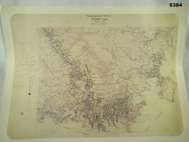
Map - Australian Topographical Survey SYDNEY / 56III Southern Half, NE Plane Table Field sheet 1915, Australian Survey Corps, 6 Dec 1915
This is a unique example of a hand drawn plane table sheet produced in the first year of the Australian Survey Corps by original members of the Corps. Roseblade and Lynch 5 Dec 1915. Of interest is the documented times that it took to create the original field sheet. Also of interest is the fact that this field sheet that was used to create the actual SYDNEY map sheet was contoured, many map sheets produced up until now were purely planimetric and lacked contouring that was needed for military use. This is a reproduction print of a photograph of the original field sheet and was printed at the Army Survey Regiment, Bendigo.Reprinted coloured Image of Australian Topographical Survey SYDNEY /56 III Southern Half, hand drawn NE Plane Table field sheet. Includes an itemized summary of work performed by HA Roseblade CSM Australian Survey Corps 1915, Signed by J Lynch Lieutenant.royal australian survey corps, rasvy, fortuna, army survey regiment, army svy regt, asr -
 Bendigo Military Museum
Literary work - DOCUMENT, SOLDIERS STORY WW2, Post WW2
Joseph Earnest WHITFORD VX25490. Refer to Cat. No. 4073.3PDocument, eight pages, typed, detailing one mans past in the battles of El Alamein in 1942. Document also has excerpts from Battalion histories.literary work, story, 2/32nd -
 Bendigo Historical Society Inc.
Document - MCCOLL, RANKIN AND STANISTREET COLLECTION: EAST CLARENCE GOLD MINING CO. N.L. - RULES, 1932
Document; document: rules of East Clarence gold mining Co. N.L. made before incorporation. East Clarence Gold Mining Company No Liability - rules.MCCOLL RANKIN & STANISTREETorganization, business, gold mining rules and regulations, mccoll rankin & stanistreet -
 Bendigo Historical Society Inc.
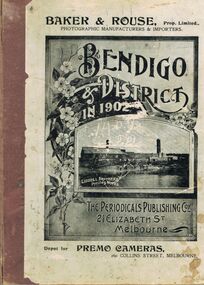
Book - BENDIGO & DISTRICT IN 1902, 1902
Book, Bendigo & District in 1902. Index of Trade and Advertisements Relating to Bendigo in 1902. This document has been scanned into M drive under shared documents.The Periodicals Publishing Coy,Elizabeth St, Melbournebook, bendigo, bendigo