Showing 4572 items
matching park street
-
 Ringwood and District Historical Society
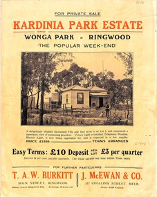
Flyer, Land Sale Brochure, Kardinia Park Estate, North Ringwood, Vic. - circa 1948
Folded buff-coloured land sale advertisement for Kardinia Park Estate in Warranwood area of North Ringwood, including terms of sale, area map, layout plan of the estate, and summary of local facilities and services. Front page features photograph of a man and dog in front of a house captioned as Lot 1 on four acres shown on the estate layout as cnr of Brysons Road and Range View Parade (later Omeo Parade). Second page includes bushland swimming pool photograph and promotional information for prospective buyers.Subdivision includes Kardinia Crescent, Wonga Road, Brysons Road, Range View Parade (later Omeo Parade), Motor Coach Road (later Wonga Park Road, then Warranwood Road). (Agent/s) T.A.W. Burkitt, Main Street, Ringwood, Phone (9 to 6) Ringwood 242, Evenings, Ringwood 157, and J. McEwan & Co, 317 Collins Street, Melbourne, Phone 6750 Central. -
 National Wool Museum
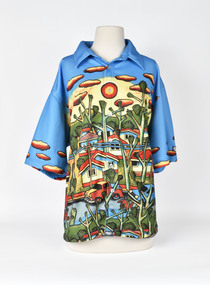
Uniform - Shirt, Mambo, Sydney 2000 Olympic Games Australian Women's Closing Ceremony Shirt, 2000
Australian women's shirt from the closing ceremony of the Sydney 2000 Olympic Games. Designed by Mambo Graphics.Short sleeved and collared with six clear plastic buttons down the right side of the shirt. Shirt features the Mambo "Suburbia" design. The collar and sleeves are blue with yellow and red clouds the rest of the shirt is made up of a suburban street scene - houses, trees, telegraph poles, parked cars and dogs and chickens running along the street. The Mambo logo appears in the centre back of the shirt above the clouds in the design. Double stitched seams. Mambofashion, woolmark company mambo graphics, sport, the woolmark company 2000 australian olympic display - exhibition (21/12/2001 - 24/05/2002), sydney 2000 olympic games -
 Wodonga & District Historical Society Inc
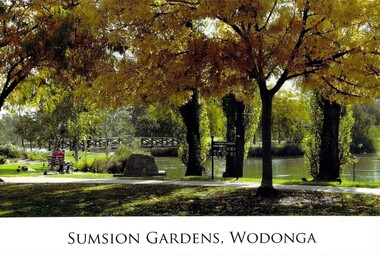
Photograph - Eric Sumsion Gardens
Mr Eric Sumsion was the gardening curator for Wodonga Shire in 1956. He had previously operated a bootmaker’s shop in High Street, Wodonga for many years. Eric saw the potential of the area in Wodonga now known as Belvoir Park and asked permission to work on part of the area. He eventually purchased a house adjoining the area giving him more time and easy access to work on it. The Lagoon, Lake Huon, Belvoir Lagoon, Belvoir Park and Sumsion Gardens are all names used over time for what is today one of Wodonga’s favourite recreation and picnic spots. In the 1800s river boats could enter Lake Huon from Wodonga Creek. There was a jetty south of where the water fountain is today. In later years, this jetty was used by the Clay Bird Shooting Club. From the early 1900s football and cricket were played there, and some mining leases were also allowed. At one time there were open gravel pits between House Creek and the main lagoon, and these were subsequently filled with town garbage collected by the Council. In the late 1940s, Wodonga Golf Club took over part of Belvoir Park for a 9-hole golf course with sand greens. The Golf Club House was built in 1946. The Club extended the course to 12-holes when the football ground moved to Martin Park and the course later extended to 18 holes. Under Eric Sumsion’s care the area became a magnificent area of parkland and curated gardens. After he had retired in 1961 his work was acknowledged by the Shire Engineer, Mr Bill Page, when the Sumsion Gardens were named in his honour. He was also responsible for the design and curating of many other gardens in Wodonga, including those at Sarah Coventry and Richardson Park. Eric Sumsion died in July 1988, aged 85.This item is significant because it acknowledges the dedication and commitment of Eric Sumsion to the Wodonga Community.A collection of photographic image and an advertisement related to the work of Eric Sumsion in Wodonga.eric sumsion, parks and gardens wodonga -
 Ballarat Tramway Museum
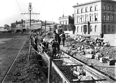
Photograph - Geelong Tramway relaying stringer constructed track
Relaying stringer constructed track in Mercer St., just west of the Gheringhap St. intersection opposite Johnstone Park, looking east towards Malop Street. The southern track has subsided and the original concrete stringers dug out, with them lying beside the track. According to the local papers, wider stringers are to be used. August 1914.Black and white print on paper.GSR710/25/1/5, 25-5, and the no. 3 inside a circle, written in pencil on the reverse. The letter A, and the no. 1 in a circle are written in ink on the reverse.geelong tramway relaying tracks, geelong streetscape c. 1914 -
 Bendigo Historical Society Inc.
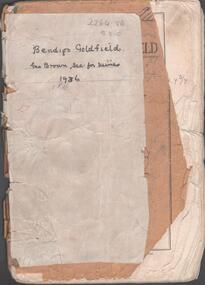
Booklet - Albert Richardson Collection: Bendigo Goldfield, MInes Department, Victoria 1936, 1936
Albert Richardson was an expert on the history of the Bendigo Goldfield. The Albert Richardson Park at Victoria Hill, is named in his honour. He was a prominent member of the Bendigo Historical Society. Fifty one page booklet. On front page: Bendigo Goldfield, issued by Geo Brown, Secretary for Mines, under the authority of The Hon. E.J. Hogan, M.L.A., Minister of Mines. Mines Department, Melbourne, Victoria, Australia, 1936.Content includes: historical information; recent development and future prospects, geology and lines of reef. Reef lines described are: Tysons, Lightning Hill, Hustlers, Derby, Paddy's Gully, Garden Gully, Deborah, Sheepshead, New Chum, Nell Gwynne, British and Foreign, Napoleon, Lancashire, Carshalton, Thistle, Christmas and Birds. On front cover 'Bendigo Goldfield, Geo Brown, Sec. for Mines, 1936' written in black pen. On first page 'A.Richardson, 29 Harrison Street, Bendigo' The booklet is annotated throughout by Albert Richardson, for example, the mines along the New Chum Line are further described with their date of formation, sill heights and area of claim.albert richardson, gold mining, goldfield, reef lines, 1936 -
 Bendigo Historical Society Inc.
Document - Hustlers, Sheepshead and Deborah lines of reef
Albert Richardson was a mining historian who wrote widely on the mines of the Bendigo Goldfield. The park opposite the Goldmines Hotel in Marong Road, is named in his honour. Five page document, hand written by Albert Richardson on lined foolscap and edited with cross-outs and insertions, . The mines along the Hustlers line of reef and the Sheepshead line of reef are described. Mines listed on Hustlers line of reef: Fortuna Hustlers (1888 - 1913), shaft 2,240 feet at rear of Buckell and Jeffrey's offices; Royal Hustlers Reserve No. 2 - two shafts 'City" 860 feet, now covered by R.S.L. building Pall Mall, steel poppet legs 60 ft high and 'Park Shaft" at rear of Camp Hill School, 1,775 feet, steel poppet legs 60 feet high; Hustlers Hill Group first worked by Jonathan Harris in 1853 and bounded by Valentine, Anderson and Ironbark Creek to the north and Milroy Street to the east, one of first areas worked for quartz reefing. It with Garden Gully line west and Victoria Hill Ironbark, formed by far the richest cross section of the Bendigo Goldfield. Great Extended Hustlers (1865-1921) close to intersection of Anderson Street and Hustlers Road, mullock heap against road and shored up around shaft, steel poppet legs now at Wattle Gully mine, Chewton, large winding machine, air compressor south of shaft and 36 head crushing battery. Hustlers Reef (Old Hustlers) and Hustlers Reef No. 1, two shafts, main 2,210 feet, about 220 yards east of Moran Street and against Fenton Street. , No. 1 shaft 1,140 feet and about 155 yards east of Moran Street. Lansell's Comet, Lightining Hill line, 2.100 feet, on Comet Hill approx 70 yards west of Holmes Road, near Comet Creek, steel poppet legs. United Hustlers and Redan (1876-1918), main Redan, 1,830 feet about 155 yards west of Sandhurst Roead, in line with Comet Hill State School, this hill known as Redan Hill. North, or New Hustlers, once known as Agnew Hustlers, wooden poppet legs, south side, Kneebone Street, Eaglehawk. Derby line, Johnson's No. 3, South Johnson's (east shaft of Collman and Tacchi) 439 feet on west wide of Woods Street, south of Wetherall Street. Paddy's Gully Line, south to north, some shafts - Lansell's 'Sandhurst" ('Needle") Eaglehawk Road shaft 2,425 feet, about 50 yards east of Needle Loops, a brick square sided chimney with Cleopatra Needle top. British American, 789 feet, just south of Holdsworth Road. Collman and Tacchi, main shaft 2,588 feet, 60 yards west of Eaglehawk Road, California Gully. Deborah Line of Reef, The Deborah (1932-1954) shaft 2.017 feet, west of Adams Road and south of Abel Street, Quarry Hill. North Deborah (1937 - 1954) shaft 1,151 feet, Breen Street, Quarry Hill, steel poppet legs. Central Deborah (1939-1954) shaft 1,347 feet Sheepshead line of reef, Lansell's South Red, White and Blue, shaft 2,124 feet, north east of Bellevue Road and 220 yards east of Adams Road. The New Red, White and Blue Consolidated (Big Blue) main shaft 2,416 feet. Lansell's Bendigo Battery 105 head, north of 'Big Blue" on his freehold lease, commenced crushing on 24th February 1895. After closing was erected as the Showground's Industrial Hall, July 1926. North Red, White and Blue, burnt down February 1926, new company 1934, closed 1938. Document is part of the Albert Richardson Collection of Bendigo mining history. bendigo, gold mining, deborah line of reef, sheepshead line of reef, hustlers line of reef, royal hustlers reserve mine, hustlers hill group of mines, great extended hustlers, hustlers reef no. 1, lightning hill line, old comet, collman and tacchi, lansell's comet, north deborah, central deborah, dhrrpdhrsf linr og trrg, new red, white and blue consolidated mine, big blue, lansell's bendigo battery, north red, white and blue mine, albert richardson collection -
 Bendigo Historical Society Inc.
Document - Kangaroo Flat Gold Mine Collection: Flora Hill Mine Report, 6th November 1985
... (79.2m) in Houlahan Street, near Brennan Park Swimming Pool... Flora Hill Mine shaft 260 ft (79.2m) in Houlahan Street, near ...Kangaroo Flat Gold Mine Collection. Eight pages (photocopy) of information relating to the Flora Hill Mine, Flora Hill, Bendigo. On first page: 'Bendigo Mining N.L. Mine Information' First two pages contain a summary of the research undertaken by Bendigo Mining N.L. with six additional photocopied pages of annotated copies of mining records. The main Flora Hill Mine shaft 260 ft (79.2m) in Houlahan Street, near Brennan Park Swimming Pool. The Flora Hill reefs were worked from the late 1850's by open cut and shallow shafts, but very little has been recorded about these working or the gold obtained. The Flora Reef Co crushed 200 tons for a return of 25 oz in 1866, a grade suggestive of open cut operations.' The mine was re-opened in 1921, at which time Whitelaw wrote a report. An extract from Whitelaw's report (24th March, 1921) is included in the report. gold mining, bendigo, flora hill mine, south flora reef gold mining company, bendigo mining n.l. -
 Bacchus Marsh & District Historical Society
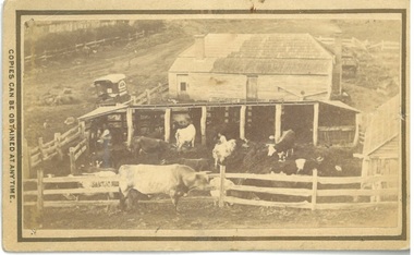
Photograph, Dairy Farm Bacchus Marsh District 1883
The number of cattle in this photo suggests that it was a small holding, at the beginning of the dairy industry in Bacchus Marsh. This industry became a major source of employment in Bacchus Marsh. By the early twentieth century, the Bacchus Marsh region was a significant contributor to the dairy industry in Australia. Small sepia unframed photograph on card with gold border framing photograph. Housed in the album, 'Photographs of Bacchus Marsh and District in 1883 by Stevenson and McNicoll'. This is a photo of a dairy farm in an unknown location in the Bacchus Marsh district. It has been taken from an elevation looking down at the farm. On the left, the roadside can be seen running alongside a stream or river which is fenced off by a line of trees and a post and rail fence. Parked on the road outside the farmhouse is a wagon which is unhitched. The wagon has a white rooftop and on the side can be seen a professional logo, details unclear. This wagon is most likely the wagon used by the photographers to access outlying properties with their photographic equipment. The farmhouse itself faces the road with side doors giving onto the yard. The roof is partially covered by new slates, possibly slate covering bark. Six milking sheds of post-and-rail construction adjoin the farm yard. In the first and fourth stalls (l to r) the farmer and his wife can be seen seated, miking cows. The rest of the herd are awaiting milking in the yard which also has a post-and-rail fence. A bull of milking shorthorn breed stands outside the fence. The milking herd itself is of various breeds; Herefords, roan shorthorn and roan and white shorthorns can be identified. On the right is a shed of rough-hewn boards and a shingle roof. In the yard at the back of the house stands a cart or dray. On the front: Stevenson & McNicoll. Photo. 108 Elizabeth St. Melbourne. COPIES CAN BE OBTAINED AT ANY TIME. On the back: LIGHT & TRUTH inscribed on a banner surmounted by a representation of the rising sun. Copies of this Portrait can be had at any time by sending the Name and Post Office Money Order or Stamps for the amount of order to STEVENSON & McNICOLL LATE BENSON & STEVENSON, Photographers. 108 Elizabeth Street, MELBOURNE. dairy farms, stevenson and mcnicoll 1883 photographs of bacchus marsh and district -
 Melbourne Tram Museum
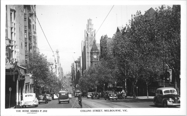
Postcard, Rose Stereograph Co, "Collins Street Melbourne", late 1940s
Rose Series postcard No. P 202, titled "Collins Street Melbourne" with a view from Russell St looking west. W2 class 574 (East Preston, route 9) is climbing the hill with another four W2's in the view as well. There is a horse-drawn delivery cart (milk? - Marche ?) parked on the north side of the street.Yields information about Collins St, late 1940sPostcard - printed real photograph with Rose Stereograph Co. name on the rear.tramways, collins st, tram 574, w2 class, trams -
 Melbourne Tram Museum
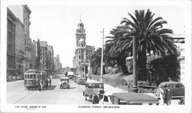
Postcard, Rose Stereograph Co, "Flinders St Melbourne", late 1930s
Rose Series postcard No. P 206, titled "Flinders St Melbourne" with W2 class tram 412 (Spencer St, route 40) westbound in Flinders St with Flinders Street Railway Station in the background. A group of ladies has alighted from the tram at the Safety Zone near Queen St. Note the "Do not park here" sign placed behind the pole on the right side of the photograph.Yields information about Flinders St late 1930sPostcard - printed real photograph with Rose Stereograph Co. name on the rear.tramways, w2 class, flinders st, tram 412, safety zone, trams, route 40 -
 Eltham District Historical Society Inc
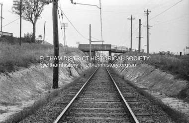
Photograph, Railway overpass on Sherbourne Road at junction of Para Road and Simms Road, Briar Hill, 3 November, 1967
Viewed from railway line opposite Graham Body Works. Simms Road is running to the right in front of the old house. The house belongs to Mrs Cameron whose daughter married a DAVEY after which Davey Street is named. Excavation work is being undertaken for the realignment of the Para Road and Sherbourne Road intersection where the current roundabout is located, approximately where the two cars are parked. Mrs Cameron's house and the other are where Montmorency Secondary College is situated. The school opened in 1969.Roll of 35mm black and white negative film, 6 strips Ilford HP3briar hill, cameron, davey, davey road, graham body works, greensborough, montmorency secondary college, sherbourne road, simms road -
 Melbourne Tram Museum
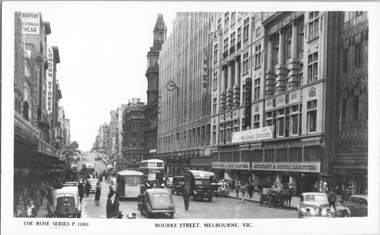
Postcard, Rose Stereograph Co, "Bourke Street Melbourne", early 1940s
Rose Series postcard No. P 1083, titled "Bourke Street Melbourne", showing a busy scene outside Buckley & Nunn Limited store and the Myer Emporium. In the view are two double decker buses, two single decker buses in the war time livery with white mudguards and white rear panels. one horse drawn cart is on the opposite of the road. There is that a gas producer pack on the back on the car parked on the left hand side of the photograph. Yields information about Bourke St early 1940s.Postcard - printed real photograph with Rose Stereograph Co. name on the rear.tramways, bourke st, buses, world war ii, td5c class, ts8c class, mmtb buses