Showing 9555 items
matching the entrance
-
 Greensborough Historical Society
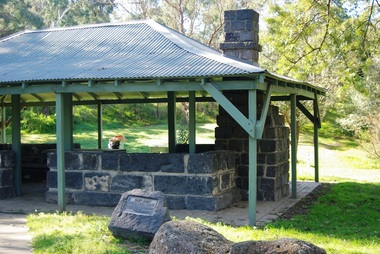
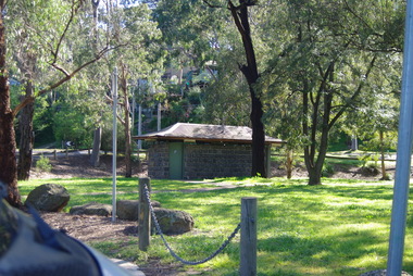
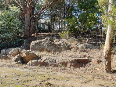
Photograph - Digital Image, Pioneer Reserve 2014 -4, 23/09/2014
Pioneer Reserve, Greensborough is a small park on the corner of St Helena and Diamond Creek Roads. It is adjacent to the site of Greensborough's first bridge across the Plenty River, c. 1864 - 1960s. The shelter, viewing platform, retaining wall and entrance are built from the bridge's massive bluestone arched abutments dismantled between 1974 and 1983. Photograph by Marilyn Smith 2014.Digital copy of colour photograph.pioneer reserve greensborough -
 Greensborough Historical Society
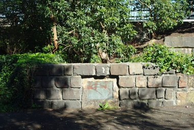
Photograph - Digital Image, Pioneer Reserve 2014 -5, 23/09/2014
Pioneer Reserve, Greensborough is a small park on the corner of St Helena and Diamond Creek Roads. It is adjacent to the site of Greensborough's first bridge across the Plenty River, c. 1864 - 1960s. The shelter, viewing platform, retaining wall and entrance are built from the bridge's massive bluestone arched abutments dismantled between 1974 and 1983. Photograph by Marilyn Smith 2014.Digital copy of colour photograph.pioneer reserve greensborough -
 Greensborough Historical Society
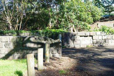
Photograph - Digital Image, Pioneer Reserve 2014 -6, 23/09/2014
Pioneer Reserve, Greensborough is a small park on the corner of St Helena and Diamond Creek Roads. It is adjacent to the site of Greensborough's first bridge across the Plenty River, c. 1864 - 1960s. The shelter, viewing platform, retaining wall and entrance are built from the bridge's massive bluestone arched abutments dismantled between 1974 and 1983. Photograph by Marilyn Smith 2014.Digital copy of colour photograph.pioneer reserve greensborough -
 Greensborough Historical Society
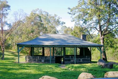
Photograph - Digital Image, Pioneer Reserve 2014, 23/09/2014
Pioneer Reserve, Greensborough is a small park on the corner of St Helena and Diamond Creek Roads. It is adjacent to the site of Greensborough's first bridge across the Plenty River, c. 1864 - 1960s. The shelter, viewing platform, retaining wall and entrance are built from the bridge's massive bluestone arched abutments dismantled between 1974 and 1983. Photograph by Marilyn Smith 2014.Digital copy of colour photograph.pioneer reserve greensborough -
 Greensborough Historical Society
Photograph - Digital Image, Pioneer Reserve 2014 -8, 23/09/2014
Pioneer Reserve, Greensborough is a small park on the corner of St Helena and Diamond Creek Roads. It is adjacent to the site of Greensborough's first bridge across the Plenty River, c. 1864 - 1960s. The shelter, viewing platform, retaining wall and entrance are built from the bridge's massive bluestone arched abutments dismantled between 1974 and 1983. Photograph by Marilyn Smith 2014.Digital copy of colour photograph.pioneer reserve greensborough -
 Greensborough Historical Society
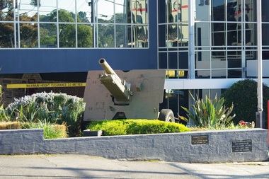
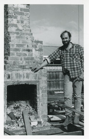
Photograph - Digital Image, Greensborough RSL - artillery piece at entrance to RSL 2, 1940o
This photo shows the artillery piece at the entrance to the Greensborough RSL (Main Street Greensborough). It is a Howitzer 25 pounder gun. It was the standard British field gun of WW2, introduced here from 1940. Australia used them in great numbers, right up to the 1960s, and even manufactured them here, hence why every RSL seems to have one. Digital copy of colour photograph.greensborough rsl -
 Orbost & District Historical Society
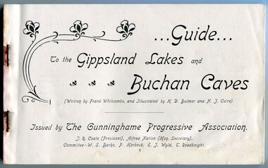
Book, The Cunninghame Progressive Association, Guide to Buchan Caves & the Gippsland Lakes, c.1900-1910
This booklet was issued as a tourist advertising/promotion for the Gippsland Lakes and Buchan Caves. It was most likely printed in the early 20th Century. This promotion also includes associated areas such as Lake Tyers, Cunninghame (Lakes Entrance), Nowa Nowa, Sale, and Bairnsdale. An early tourist promotion for East Gippsland, focussing on Melbourne tourists travelling to Sale or Bairnsdale by train, and then by steamer or coach. An example of an early tourism promotion.A booklet of 103 pages, printed in b/w. The cover is a dk. red paper with gold print, quite fragile. The book contains b/w photographs, advertisements, time tables for trains and steamers travelling through the Gippsland Lakes from Sale to Cunninghame (eg. SS JCD), also a map of the steamer route. ...Guide... To the Gippsland Lakes and Buchan Caves (Written by Frank Whitcombe, and Illustrated by H D Bulmer and N J Caire). Issued by The Cunninghame Progressive Association. J R Coate (President), Alfred Nation (Hon. Secretary), Committee - W S Barke, P Harbeck, E J Wyld, T Roadknightbuchan caves, gippsland lakes, ss j c d, tourism -
 Tatura Irrigation & Wartime Camps Museum
Photo album
1st photo colour of entrance gates of Camp 13. T & D History Society Museum. Inside front cover typed Kormoran German Raiders. Painting by Geo Rosenkranz; Graytown camp WW2 - self portrait of Geo Rosenkranz - Graytown camp 1945. The original paintings were lent by Mrs Margaret Shannon nee Oliver, of Katandra West.Grey blue album, gold rectangular stripe. T & D Hist Society Museum. Inside front cover typed Kormoran German Raiders. Painting by Geo Rosenkranz; Greytown camp WW2 - self portrait of Geo Rosenkranz - Greytown camp 1945. The original paintings were lent by Mrs Margaret Shannon nee Oliver, of Katandra West.camp 13 -
 Stawell Historical Society Inc
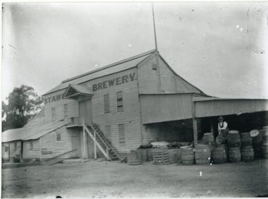
Photograph, Brewery Building of the Stawell Brewery originally owned by Thomas Powell and later Bryant and Co in Stawell West near the Botanical Reserve
Wooden Brewery Building Stawell Brewery originally owned by Thomas Powell and later Bryant and Co. Located Stawell West near the Botanical Reserve. Closed about 1918. where there are scores of Hotels common sense says "Build a Brewery" and share the takings. Stawell Brewery was situated in part of the present Caravan Park. Almost opposite the entrance to the RacecourseTwo Story wooden Building with additions to left. A Man sitting on Barrels to the right.Stawell Breweerystawell, stawell brewery -
 Ballarat Heritage Services
Photograph - Photograph - Colour, Clare Gervasoni, Pulpit Rock, Magpie, Victoria, 2019, 18/05/2019
Wesleyans at Magpie collected money to built a tent chapel at Magpie, but the rush had moved on before it was erected so the tent was taken to Ballarat where it becme the basis of the Lydiard Street Wesleyan Church (now Uniting Church). A bluestone church was later bulit above the Magpie School which was demolished in the 1960s with the stone used in the entrance building at Sovereign Hill.A large rock at Magpie, beside the Yarrowee Creek, was called Pulpit Rock. It was at this rock that the early miners gathered in 1853 for open air religious services. magpie, wesleyan church, religion, pulpit rock, geology -
 Buninyong & District Historical Society
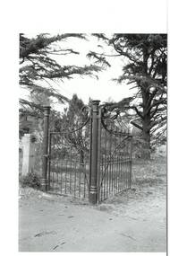
Photograph - Original B/W Photograph, Mr Clive J Brooks, Buninyong Cemetery gates, 9/4/1994
Cast iron gates commissioned from foundry at Castlemaine, for entrance to Buninyong Cemetery, Midland Highway. One pedestrian gate, one double gate. Gates acquired 1894. Originally olive green, gold-tipped spears. Painted white 1930s - 1940s. Damaged c1985, repaired by Mr Ron Nicholls, Buninyong. Repainted olive green 1992.Historically significant original gates acquired 1894.Buninyong Cemetery cast iron gatesbuninyong cemetery, gates, cast iron -
 Surrey Hills Historical Society Collection
Photograph, Entrance to Wattle Park from Riversdale Road, 1912-1914
Information provided by Stan Smith: Riversdale Road looking east 1912-1914. Wattle Park, then a farm is on the right. The near row of trees across the picture, indicates the driveway in Wattle Park. Wattle Park was then Fenwick's farm - or - Fennies to the local boys. Note: Riversdale Road becomes not much more than a track after passing the farm entrance.A dirt road in the lower left corner of the photograph is bounded by a post and rail fence. Two cyclists are on the road. "Wattle Park" is written to the right side of the road.wattle park, 1912, farms, 1914, fenwicks farm, fennies, fences, trees, roads and streets, riversdale road, pine trees, gum trees, cyclists -
 City of Greater Bendigo - Civic Collection
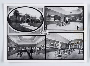
Souvenir - Reproduction of postcard, Bendigo Art Gallery
Bendigo Art Gallery was founded in 1887 and has over the years undergone extensive building and renovation programs in recent years adding a new contemporary wing, storage areas, and a new entrance and gallery shop. This photographic reproduction of an older post card shows the interior of the rooms now known as the 'historic courts' and an exterior front view c. 1910. Photographic reproduction of unknown post card. Possibly larger than original size. Writing on reverse. Believed to be related to Cat No 0306.Reverse: BENDIGO ART GALLERY 1910 / "The interior architecture remains / largely the same.' / *This photograph is the property / of the Bendigo Art Gallery, and / should be returned promptly.bendigo art gallery, city of greater bendigo tourism -
 City of Greater Geelong
Painting - Tempera, Robert Ingpen, Geelong Character Mural, c.1960
Robert Ingpen, illustrator, designer, writer and consultant, was born in Geelong in 1936. He was educated in Geelong before studying art and illustration under Harold Freedman at the Royal Melbourne Institute of Technology, 1955-58. Early in his career he specialised in relating design to scientific research, and this included work as a graphic design artist for the CSIRO, 1958-67, commissions for designing pamphlets on fisheries for the United Nations in Mexico and Peru, and involvement in a number of Australian conservation and environmental projects. He launched into freelance work in 1968. Ingpen's work has focused on environmental and heritage issues and his exploration of fantasy and imagination. He is best known as an illustrator, and as an author of children's books, and historical books and pamphlets for adults. He has painted murals on public buildings, designed the flag and coat of arms for the Northern Territory, and designed postage stamps, including stamps for the Captain Cook Bicentenary and the 50th anniversary of CSIRO. He has been involved in a number of conservation and environmental projects, including the establishment of the Swan Hill Pioneer Settlement as consultant/designer. He was one of the founders of the Australian Conservation Foundation. Ingpen rose to prominence with his illustrations for Colin Thiele's classic children's story Storm Boy, winning for him the first Visual Arts Board award for children's book illustration. He won the international Hans Christian Anderson Medal for children's literature in 1986, and the Dromkeen Medal in 1989.Robert Ingpen, celebrated Geelong artist, was commissioned to paint a mural to be located above the entrance of the new west wing. The mural was designed to represent the objects and systems that characterise Geelong and its district and that played a major role in the city’s growth and development. The three systems comprise: the natural (producing) system; the man-made or technological system, and the natural (trading) system.ingpen, mural, city hall geelong, james harrison -
 Bendigo Military Museum
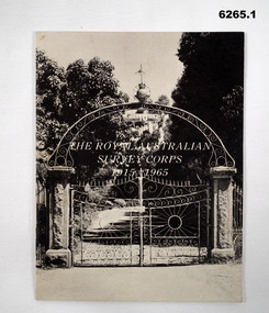
Booklet - The Royal Australian Survey Corps 1915-1965, Army Headquarters Survey Regiment, 14.11.1965
A booklet produced to commemorate the 50th (Jubilee) Anniversary of the Royal Australian Survey Corps, contains an historical record of the Corps units, nominal roll of AHQ Survey Regiment unit members during the Jubilee year, photos and plans of Fortuna Villa.Booklet, 16 pages 6265.1 Front cover has black and white photo of the gated entrance to Fortuna Villa 6265.2 Front cover has an extract from the 1:100,000 map of Canberra, ACT. 6265.2 Internal contents are a reprint of 6265.1Inside of the booklet is signed by LtCol JK Nolan CO AHQ Svy Regt, later Director of the Survey Corps.royal australian survey corps, rasvy, fortuna, army survey regiment, army svy regt, asr -
Federation University Historical Collection
Photograph - Photograph - black and white, Mount Helen Physical Education and Sports Facilities, c1982
Photograph of the Mt Helen Campus, including the library, Union Building. .1 Free standing squash court .2 Roadway from north west entrance .3 Western facade of the Physical Education Building (P Building) .4 and .5 oval .mount helen campus, buildings, physical education, squash court, oval, p building -
Federation University Historical Collection
Photograph - Photograph - black and white, Construction of the Mount Helen Library and Union Building, 1972, c1982
Photograph of the Mt Helen Campus, including the library, Union Building. .1 Free standing squash court .2 Roadway from north west entrance .3 Western facade of the Physical Education Building (P Building) .4 and .5 oval .mount helen campus, buildings, physical education, squash court, oval, p building -
Federation University Historical Collection
Photograph, Iain Reid, John Sharpham and Doug Wright
Couour photographs of John Sharpham (Director Ballarat University College) and painting lecturers Iain Reid and Doug Wright standing n front of Iain Reid's painting .Both artists were commissioned to paint an artwork for the entrance of the Vice Chancellor's Office.john sharpham, iain reid, doug wright -
 Glen Eira Historical Society
Photograph, Gloucester Court, 3, Murrumbeena, 2001
Originally labelled "Beauville Estate, Established 1936, Still Thriving 65 years on, 10th March 2001", the Beauville Estate Album contains colour photographs of houses in the Estate. They were taken around the time of the Beauville Estate’s 65th Heritage Celebration held on 10/03/2001 and donated to the Caulfield Historical Society shortly afterwards. Photographer unknown. City of Glen Eira’s Heritage Management Plan Vol 2 p79 (this is p84 of the pdf version) – HO12 Beauville Estate and environs, Murrumbeena: The Beauville Historic Area is important at the State level as the first large housing estate undertaken by the AV Jennings Construction Co, later Jennings Group Limited, Victoria’s largest home builder. It is important also as a very early estate development incorporating a range of features other than houses and including made roads, shops and recreation facilities. In this respect it was the forerunner of the comprehensively planned housing estate of the post war era. The estate is distinguished by its aesthetic values, as is the earlier and comparable Hillcrest Estate, which are formed by a combination of restrained diversity in house styles, with the exception of no. 30 in the emerging International style, and by a landscaped garden environment. Colour photograph of a double storey, white rendered brick house with unpainted variegated brown brick features. Other features include a dormer window, tiled roof, porch with arched entrances, brick paving and an unfinished brick wall beside the drive. No.3murrumbeena, houses, architectural styles, 1930's, inter war style, a.v. jennings, av jennings, jennings, brick houses, beauville estate, gloucester court, sir albert victor jennings, a v jennings construction co, beauville estate heritage area, glen eira city council, architectural features, jennings group limited, land subdivision, gardens, beauville historic area, rendered houses, brick features, dormer windows, arches, brick fences -
 Glen Eira Historical Society
Photograph, Dalny Road, 9, Murrumbeena, 2001
Originally labelled "Beauville Estate, Established 1936, Still Thriving 65 years on, 10th March 2001", the Beauville Estate Album contains colour photographs of houses in the Estate. They were taken around the time of the Beauville Estate’s 65th Heritage Celebration held on 10/03/2001 and donated to the Caulfield Historical Society shortly afterwards. Photographer unknown. City of Glen Eira’s Heritage Management Plan Vol 2 p79 (this is p84 of the pdf version) – HO12 Beauville Estate and environs, Murrumbeena: The Beauville Historic Area is important at the State level as the first large housing estate undertaken by the AV Jennings Construction Co, later Jennings Group Limited, Victoria’s largest home builder. It is important also as a very early estate development incorporating a range of features other than houses and including made roads, shops and recreation facilities. In this respect it was the forerunner of the comprehensively planned housing estate of the post war era. The estate is distinguished by its aesthetic values, as is the earlier and comparable Hillcrest Estate, which are formed by a combination of restrained diversity in house styles, with the exception of no. 30 in the emerging International style, and by a landscaped garden environment. Colour photograph of a rendered brick house with unpainted decorative variegated brown brick features. Other features include tiled roof, chimneys, sash windows, concrete driveway, garage, porch with an arched entrance and a low unpainted brick fence in the foreground. murrumbeena, houses, architectural styles, 1930's, inter war style, a.v. jennings, av jennings, jennings, brick houses, beauville estate, dalny road, porches, sir albert victor jennings, a v jennings construction co, beauville estate heritage area, glen eira city council, architectural features, jennings group limited, land subdivision, beauville historic area, brick features, chimneys, garage (private), arches, sash windows, rendered houses -
Bendigo Historical Society Inc.
Photograph - FORTUNA COLLECTION: PLAN DRAWING FORTUNA VILLA
Plan of Fortuna villa entrance and garden elevations copied onto acetate material ( copies of original drawings). Written on top 'Fortuna Villa, G. Lansell Esq. Scale 8 feet to one inch.' Possibly originals drawn by W. Beebe.bendigo, house, fortuna villa -
Port Melbourne Historical & Preservation Society
Photograph - Beach Street, Sandridge, William S Paterson, 1920s
Photographed in 1872 by William PATERSON as one of a series for the Melbourne Exhibition of 1873; original mount hanging in Engineering Department at Port Melbourne Town Hall at 19-9-1994 but now in Port Phillip,City Collection. This set of original prints belonged to Town Clerk Syd ANDERSON, then to his daughter-in-law Phyllis ANDERSON (donor). Accompanied by list of captions, both hand written and typed (the latter a partial listing).View of Beach Street from gate at Port Melbourne railway station entrance (corner of Railway Place and Princes Street). Shows Urquhart London Hotel, shops later replaced by Swallow & Ariell, carriages, sugar works chimney, etc 1872"P Anderson" on back, ink. On face of photo someone has in the 1990s added a numeral in ink 9hile with the donor. This has been retouched out on our digital copies.transport - horse, transport - railways, london family hotel, beach street, sydney sims anderson, town clerks, business and traders - hotels -
 Port Melbourne Historical & Preservation Society
Photograph - J Kitchen & Sons perimeter survey, Munro Street, Dec 2013
As the former j Kitchen & Sons site was being cleared, Lionel Layfield, who had worked at the site for many years undertook several pictorial perimeter surveys. These photos were taken in Dec 2013.Series 1 of colour photographs taken by Lionel Layfield as he walked around the perimeter of the J Kitchen & Sons Pty Ltd factory site during the early demolition of most of the buildings. .09-.15 - from Munro St entrance by the weighbridgeindustry - manufacturing, built environment - industrial, business and traders - soaps/candles, demolitions, j kitchen & sons pty ltd, symex holdings ltd, north port oval, port melbourne cricket and football oval -
Lakes Entrance Regional Historical Society (operating as Lakes Entrance History Centre & Museum)
Book, St Brendans Parish Lakes Entrance Memories from 1930-1994, 1994
Reminiscences of St Brendans Roman Catholic Parish of lakes Entrance Victoria. memories of boyhood in 1930, befoe the St Brendans School was established are recalled and parish activities up to 1994, including the disastrous fire of 7 January 1978 when threligion, schools -
Lakes Entrance Regional Historical Society (operating as Lakes Entrance History Centre & Museum)
Postcard, 1910 c
Note on back Happy Christmas to all from Aunt AliceBlack and white postcard showing SS Gippsland in Reeves Channel below Jemmys Point heading towards town East end of Rigby and Snake Island shown Fish pens visible along Hopeton Channelk shoreline Lakes Entrance VictoriaView from Jemmys Point towards fish pensships and shipping, waterways, township -
Lakes Entrance Regional Historical Society (operating as Lakes Entrance History Centre & Museum)
Photograph, Fish M, 1900 c
Coloured photograph of original oil painting by Walter Seahusan scene from Kalimna jetty looking west toward Maringa Creek and showing mill workers cottages wharf barge at Maringa creek and fishermans cottages on right Lakes Entrance Victoriaships and shipping, jetties -
 Lakes Entrance Regional Historical Society (operating as Lakes Entrance History Centre & Museum)
Photograph, 2009
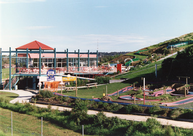
Kinkuna Amusement Park was opened 19 December 1987, closed 2002, building demolished or removed, land sold and subdivided into residential allotments.Copy colour photographic print showing Kinkuna Amusement Park on Princes Highway, owned by Joe and Shirley Walters. Photo shows main building and restaurant, mini golf, long taboggan on hill, garden and other attractions. Lakes Entrance Victoriaentertainment, recreation -
 Lakes Entrance Regional Historical Society (operating as Lakes Entrance History Centre & Museum)
Photograph, Lakes Post Newspaper, 1991
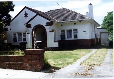
Newspaper article appeared in Lakes Post 28 August 1991Black and white photograph showing Graham Ellis demolishing a residence at 37 Carpenter Street, formerly lived in by Viv and Tommy Harbeck. During demolition many old newspapers were found. Site was redeveloped as residential units. Lakes Entrance Victoriahouses -
 Lakes Entrance Regional Historical Society (operating as Lakes Entrance History Centre & Museum)
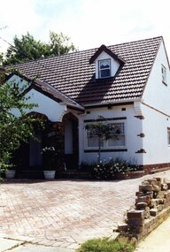
Photograph, 1999
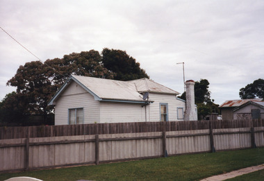
Demolished, replaced with town houses. Occupied by Mrs Vass 1970's - 1980's.Colour photograph of a private residence at 44 Roadknight Street. Dwelling of timber with corrugated iron roof, external chimney. Appears to have been a hip roofed small fisherman's cottage, large gable roofed extension at front. Lakes Entrance Victoriahouses, heritage study -
 Lakes Entrance Regional Historical Society (operating as Lakes Entrance History Centre & Museum)
Photograph, Holding M, 2000
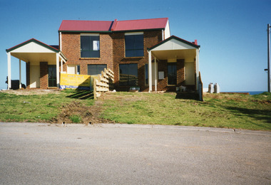
'For Sale' sign in yardColour photograph of two semi-detached houses built of site previously part of Merrangbaur, first family residence. Built of brick, colour bond roof, front of houses facing ocean view, garages facing street. Lakes Entrance Victoriahouses, heritage study