Showing 5358 items matching " timber"
-
 Eltham District Historical Society Inc
Photograph, Strath Creek, Autumn Excursion, Hume and Hovell's 1824 expedition, 26 May 1996, 26/05/1996
[article by Bettina Woodburn in EDHS Newsletter No. 109, July 1996:] ON THE TRAIL OF HUME AND HOVELL - REPORT ON THE AUTUMN EXCURSION - On a green and fresh morning (Sunday 26th May 1996) the Cobb and Co coach (driven by the most obliging Peter Tampion) set off in a north easterly direction from Eltham to connect with Hume and Hovell's route on their 1824 explorations of central Victoria. The Society would follow a series of monuments erected for the 1924 centenary of the expedition from King Parrot Creek (Tuesday 7th December 1824), through Strath Creek, over Sunday Creek (Sunday 12th December 1824) at Broadford, Tullamarine, St Albans, Deer Park, through Werribee, skirting east of the You Yangs to Lara and Avalon Beach. Because their distance-measuring wheel had broken and a one degree mistake was made in calculations, the two leaders of the original group of six convict-companions arrived at Corio Bay, instead of the expected Western Port, discovered earlier by Flinders. From below Mt. Disappointment (Hume and Hovell's difficulties in "scrambling over brush and rock", "leeches in forest, as well as no water", "cutting grass 4-5 ft. high", dreadful scrub", "devil flies") we took an easier route, saw the Strath Creek memorial in ground fog and a wonderful "field of dreams", the Hume-Hovell privately owned cricket ground with its white picket boundary fence. Now, after a steep climb, in sunshine under gums we stretched and viewed magnificent rolling hills and fog-filled valleys - not "smoke from Aborigines' bush fires". After morning tea at Broadford we followed the Sunday Creek valley beside the Hume Freeway, passed the Wallan Wallan Rest Area (more appropriately Hume and Hovell Rest Area) to tum right at Beveridge. In Gellibrand Hill Park, near the headwaters of the Moonee Ponds Creek, we experienced the landscape the first European settlers saw - huge river red gums and rolling pastures. The gardens and sheltered courtyard of the 1840s, timber, brought from .....[?] prefabricated Woodlands Homestead, provided a pleasant lunch stop. We enjoyed a private tour, panoramic views over Melbourne and surroundings and the excitement of arriving and departing aircraft. Our next river crossing was at Werribee, "in a vast treeless plain", then we drove on by-ways no coach had previously travelled, to find "an immense sheet of water" salty Corio Bay, off-course to the west. In late afternoon of a super, calm, late autumn day we headed homewards. Back at Eltham we were rather surprised to find that we had travelled a total of 347 km. Thanks again to Russell Yeoman for his research and organization. What a wonderful day! Colour photographactivities, monument, hume and hovell, murchison valley, strath creek -
 Eltham District Historical Society Inc
Photograph, Murchison Gap viewed from Strath Creek, Autumn Excursion, Hume and Hovell's 1824 expedition, 26 May 1996, 26/05/1996
[article by Bettina Woodburn in EDHS Newsletter No. 109, July 1996:] ON THE TRAIL OF HUME AND HOVELL - REPORT ON THE AUTUMN EXCURSION - On a green and fresh morning (Sunday 26th May 1996) the Cobb and Co coach (driven by the most obliging Peter Tampion) set off in a north easterly direction from Eltham to connect with Hume and Hovell's route on their 1824 explorations of central Victoria. The Society would follow a series of monuments erected for the 1924 centenary of the expedition from King Parrot Creek (Tuesday 7th December 1824), through Strath Creek, over Sunday Creek (Sunday 12th December 1824) at Broadford, Tullamarine, St Albans, Deer Park, through Werribee, skirting east of the You Yangs to Lara and Avalon Beach. Because their distance-measuring wheel had broken and a one degree mistake was made in calculations, the two leaders of the original group of six convict-companions arrived at Corio Bay, instead of the expected Western Port, discovered earlier by Flinders. From below Mt. Disappointment (Hume and Hovell's difficulties in "scrambling over brush and rock", "leeches in forest, as well as no water", "cutting grass 4-5 ft. high", dreadful scrub", "devil flies") we took an easier route, saw the Strath Creek memorial in ground fog and a wonderful "field of dreams", the Hume-Hovell privately owned cricket ground with its white picket boundary fence. Now, after a steep climb, in sunshine under gums we stretched and viewed magnificent rolling hills and fog-filled valleys - not "smoke from Aborigines' bush fires". After morning tea at Broadford we followed the Sunday Creek valley beside the Hume Freeway, passed the Wallan Wallan Rest Area (more appropriately Hume and Hovell Rest Area) to tum right at Beveridge. In Gellibrand Hill Park, near the headwaters of the Moonee Ponds Creek, we experienced the landscape the first European settlers saw - huge river red gums and rolling pastures. The gardens and sheltered courtyard of the 1840s, timber, brought from .....[?] prefabricated Woodlands Homestead, provided a pleasant lunch stop. We enjoyed a private tour, panoramic views over Melbourne and surroundings and the excitement of arriving and departing aircraft. Our next river crossing was at Werribee, "in a vast treeless plain", then we drove on by-ways no coach had previously travelled, to find "an immense sheet of water" salty Corio Bay, off-course to the west. In late afternoon of a super, calm, late autumn day we headed homewards. Back at Eltham we were rather surprised to find that we had travelled a total of 347 km. Thanks again to Russell Yeoman for his research and organization. What a wonderful day! Colour photographactivities, hume and hovell, murchison valley, murchison gap, strath creek -
 Eltham District Historical Society Inc
Photograph, Autumn Excursion, Hume and Hovell's 1824 expedition, 26 May 1996, 26/05/1996
[article by Bettina Woodburn in EDHS Newsletter No. 109, July 1996:] ON THE TRAIL OF HUME AND HOVELL - REPORT ON THE AUTUMN EXCURSION - On a green and fresh morning (Sunday 26th May 1996) the Cobb and Co coach (driven by the most obliging Peter Tampion) set off in a north easterly direction from Eltham to connect with Hume and Hovell's route on their 1824 explorations of central Victoria. The Society would follow a series of monuments erected for the 1924 centenary of the expedition from King Parrot Creek (Tuesday 7th December 1824), through Strath Creek, over Sunday Creek (Sunday 12th December 1824) at Broadford, Tullamarine, St Albans, Deer Park, through Werribee, skirting east of the You Yangs to Lara and Avalon Beach. Because their distance-measuring wheel had broken and a one degree mistake was made in calculations, the two leaders of the original group of six convict-companions arrived at Corio Bay, instead of the expected Western Port, discovered earlier by Flinders. From below Mt. Disappointment (Hume and Hovell's difficulties in "scrambling over brush and rock", "leeches in forest, as well as no water", "cutting grass 4-5 ft. high", dreadful scrub", "devil flies") we took an easier route, saw the Strath Creek memorial in ground fog and a wonderful "field of dreams", the Hume-Hovell privately owned cricket ground with its white picket boundary fence. Now, after a steep climb, in sunshine under gums we stretched and viewed magnificent rolling hills and fog-filled valleys - not "smoke from Aborigines' bush fires". After morning tea at Broadford we followed the Sunday Creek valley beside the Hume Freeway, passed the Wallan Wallan Rest Area (more appropriately Hume and Hovell Rest Area) to tum right at Beveridge. In Gellibrand Hill Park, near the headwaters of the Moonee Ponds Creek, we experienced the landscape the first European settlers saw - huge river red gums and rolling pastures. The gardens and sheltered courtyard of the 1840s, timber, brought from .....[?] prefabricated Woodlands Homestead, provided a pleasant lunch stop. We enjoyed a private tour, panoramic views over Melbourne and surroundings and the excitement of arriving and departing aircraft. Our next river crossing was at Werribee, "in a vast treeless plain", then we drove on by-ways no coach had previously travelled, to find "an immense sheet of water" salty Corio Bay, off-course to the west. In late afternoon of a super, calm, late autumn day we headed homewards. Back at Eltham we were rather surprised to find that we had travelled a total of 347 km. Thanks again to Russell Yeoman for his research and organization. What a wonderful day! Colour photographactivities, hume and hovell -
 Eltham District Historical Society Inc
Photograph, Sign to Hume and Hovell Cricket Ground, at Allandale Road, Strath Creek, Autumn Excursion, Hume and Hovell's 1824 expedition, 26 May 1996, 26/05/1996
[article by Bettina Woodburn in EDHS Newsletter No. 109, July 1996:] ON THE TRAIL OF HUME AND HOVELL - REPORT ON THE AUTUMN EXCURSION - On a green and fresh morning (Sunday 26th May 1996) the Cobb and Co coach (driven by the most obliging Peter Tampion) set off in a north easterly direction from Eltham to connect with Hume and Hovell's route on their 1824 explorations of central Victoria. The Society would follow a series of monuments erected for the 1924 centenary of the expedition from King Parrot Creek (Tuesday 7th December 1824), through Strath Creek, over Sunday Creek (Sunday 12th December 1824) at Broadford, Tullamarine, St Albans, Deer Park, through Werribee, skirting east of the You Yangs to Lara and Avalon Beach. Because their distance-measuring wheel had broken and a one degree mistake was made in calculations, the two leaders of the original group of six convict-companions arrived at Corio Bay, instead of the expected Western Port, discovered earlier by Flinders. From below Mt. Disappointment (Hume and Hovell's difficulties in "scrambling over brush and rock", "leeches in forest, as well as no water", "cutting grass 4-5 ft. high", dreadful scrub", "devil flies") we took an easier route, saw the Strath Creek memorial in ground fog and a wonderful "field of dreams", the Hume-Hovell privately owned cricket ground with its white picket boundary fence. Now, after a steep climb, in sunshine under gums we stretched and viewed magnificent rolling hills and fog-filled valleys - not "smoke from Aborigines' bush fires". After morning tea at Broadford we followed the Sunday Creek valley beside the Hume Freeway, passed the Wallan Wallan Rest Area (more appropriately Hume and Hovell Rest Area) to tum right at Beveridge. In Gellibrand Hill Park, near the headwaters of the Moonee Ponds Creek, we experienced the landscape the first European settlers saw - huge river red gums and rolling pastures. The gardens and sheltered courtyard of the 1840s, timber, brought from .....[?] prefabricated Woodlands Homestead, provided a pleasant lunch stop. We enjoyed a private tour, panoramic views over Melbourne and surroundings and the excitement of arriving and departing aircraft. Our next river crossing was at Werribee, "in a vast treeless plain", then we drove on by-ways no coach had previously travelled, to find "an immense sheet of water" salty Corio Bay, off-course to the west. In late afternoon of a super, calm, late autumn day we headed homewards. Back at Eltham we were rather surprised to find that we had travelled a total of 347 km. Thanks again to Russell Yeoman for his research and organization. What a wonderful day! Colour photographactivities, hume and hovell, allandale road, strath creek -
 Eltham District Historical Society Inc
Photograph, Autumn Excursion, Hume and Hovell's 1824 expedition, 26 May 1996, 26/05/1996
[article by Bettina Woodburn in EDHS Newsletter No. 109, July 1996:] ON THE TRAIL OF HUME AND HOVELL - REPORT ON THE AUTUMN EXCURSION - On a green and fresh morning (Sunday 26th May 1996) the Cobb and Co coach (driven by the most obliging Peter Tampion) set off in a north easterly direction from Eltham to connect with Hume and Hovell's route on their 1824 explorations of central Victoria. The Society would follow a series of monuments erected for the 1924 centenary of the expedition from King Parrot Creek (Tuesday 7th December 1824), through Strath Creek, over Sunday Creek (Sunday 12th December 1824) at Broadford, Tullamarine, St Albans, Deer Park, through Werribee, skirting east of the You Yangs to Lara and Avalon Beach. Because their distance-measuring wheel had broken and a one degree mistake was made in calculations, the two leaders of the original group of six convict-companions arrived at Corio Bay, instead of the expected Western Port, discovered earlier by Flinders. From below Mt. Disappointment (Hume and Hovell's difficulties in "scrambling over brush and rock", "leeches in forest, as well as no water", "cutting grass 4-5 ft. high", dreadful scrub", "devil flies") we took an easier route, saw the Strath Creek memorial in ground fog and a wonderful "field of dreams", the Hume-Hovell privately owned cricket ground with its white picket boundary fence. Now, after a steep climb, in sunshine under gums we stretched and viewed magnificent rolling hills and fog-filled valleys - not "smoke from Aborigines' bush fires". After morning tea at Broadford we followed the Sunday Creek valley beside the Hume Freeway, passed the Wallan Wallan Rest Area (more appropriately Hume and Hovell Rest Area) to tum right at Beveridge. In Gellibrand Hill Park, near the headwaters of the Moonee Ponds Creek, we experienced the landscape the first European settlers saw - huge river red gums and rolling pastures. The gardens and sheltered courtyard of the 1840s, timber, brought from .....[?] prefabricated Woodlands Homestead, provided a pleasant lunch stop. We enjoyed a private tour, panoramic views over Melbourne and surroundings and the excitement of arriving and departing aircraft. Our next river crossing was at Werribee, "in a vast treeless plain", then we drove on by-ways no coach had previously travelled, to find "an immense sheet of water" salty Corio Bay, off-course to the west. In late afternoon of a super, calm, late autumn day we headed homewards. Back at Eltham we were rather surprised to find that we had travelled a total of 347 km. Thanks again to Russell Yeoman for his research and organization. What a wonderful day! Colour photographactivities, hume and hovell -
 Eltham District Historical Society Inc
Photograph, Autumn Excursion, Hume and Hovell's 1824 expedition, 26 May 1996, 26/05/1996
[article by Bettina Woodburn in EDHS Newsletter No. 109, July 1996:] ON THE TRAIL OF HUME AND HOVELL - REPORT ON THE AUTUMN EXCURSION - On a green and fresh morning (Sunday 26th May 1996) the Cobb and Co coach (driven by the most obliging Peter Tampion) set off in a north easterly direction from Eltham to connect with Hume and Hovell's route on their 1824 explorations of central Victoria. The Society would follow a series of monuments erected for the 1924 centenary of the expedition from King Parrot Creek (Tuesday 7th December 1824), through Strath Creek, over Sunday Creek (Sunday 12th December 1824) at Broadford, Tullamarine, St Albans, Deer Park, through Werribee, skirting east of the You Yangs to Lara and Avalon Beach. Because their distance-measuring wheel had broken and a one degree mistake was made in calculations, the two leaders of the original group of six convict-companions arrived at Corio Bay, instead of the expected Western Port, discovered earlier by Flinders. From below Mt. Disappointment (Hume and Hovell's difficulties in "scrambling over brush and rock", "leeches in forest, as well as no water", "cutting grass 4-5 ft. high", dreadful scrub", "devil flies") we took an easier route, saw the Strath Creek memorial in ground fog and a wonderful "field of dreams", the Hume-Hovell privately owned cricket ground with its white picket boundary fence. Now, after a steep climb, in sunshine under gums we stretched and viewed magnificent rolling hills and fog-filled valleys - not "smoke from Aborigines' bush fires". After morning tea at Broadford we followed the Sunday Creek valley beside the Hume Freeway, passed the Wallan Wallan Rest Area (more appropriately Hume and Hovell Rest Area) to tum right at Beveridge. In Gellibrand Hill Park, near the headwaters of the Moonee Ponds Creek, we experienced the landscape the first European settlers saw - huge river red gums and rolling pastures. The gardens and sheltered courtyard of the 1840s, timber, brought from .....[?] prefabricated Woodlands Homestead, provided a pleasant lunch stop. We enjoyed a private tour, panoramic views over Melbourne and surroundings and the excitement of arriving and departing aircraft. Our next river crossing was at Werribee, "in a vast treeless plain", then we drove on by-ways no coach had previously travelled, to find "an immense sheet of water" salty Corio Bay, off-course to the west. In late afternoon of a super, calm, late autumn day we headed homewards. Back at Eltham we were rather surprised to find that we had travelled a total of 347 km. Thanks again to Russell Yeoman for his research and organization. What a wonderful day! Colour photographactivities, hume and hovell -
 Flagstaff Hill Maritime Museum and Village
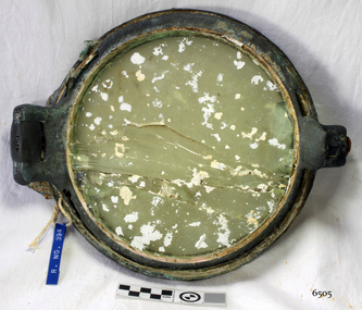
Functional object - Porthole, c 1888
This porthole was part of the ship's fittings when the Antares was constructed. THE ANTARES In mid-November 1914, after the beginning of the First World War, a young local man went one evening to fish near the Bay of Islands, west of Peterborough. He later arrived home hurriedly and in an agitated state declaring: "The Germans are coming!" His family laughed and disbelieved him, as this young fellow was prone to telling fictional tales. About a month later, on December 13th 1914, local farmers Phillip Le Couteur and Peter Mathieson were riding in the vicinity, checking on cattle. Phillip Le Couteur saw what he “thought was the hull of a ship below the cliffs.” He rode to Allansford and contacted police. The next day, two Constables and Phillip Le Couteur returned to the site, where they dug a trench near the top of the cliff and sank a log in it. To this they attached a rope, which they threw down the cliff face. Constable Stainsbury and Phillip Le Couteur then made the dangerous descent down the rope on the sheer cliff face. They found wreckage strewn around a small cove and a portion of a man's body under the cliffs. The hull of the ship could be seen about 300 metres out to sea. Some of the wreckage revealed the name Antares and the remains of the ship's dinghy bore the name Sutlej. During the next two weeks and with the help of the Warrnambool lifeboat and crew, two more bodies were found. Later investigations proved that the tragic wreck was indeed that of the Antares, reported overdue on the 207th day of her voyage from Marseilles, France, to Melbourne. She was a three masted, 1749 ton iron clipper, built in Glasgow in 1888 and originally named and launched as the Sutlej. Bought in 1907 by Semider Bros. from Genoa, Italy, she was refitted and renamed Antares. It was later realised that the local lad who a month earlier had declared he had seen German guns being fired, had probably seen distress flares fired from the deck of the Antares the night she was wrecked. She was last sailed under Captain Gazedo and wrecked at what is now known as Antares Rock, near the Bay of Islands. She had been carrying a large cargo of roofing tiles from France to Melbourne, consigned to Mullaly & Byrne. Many of them are now to be seen amongst the battered and scattered remains of the wreck. Some of the timbers were found to be blackened by fire. An Information Board has been erected on the cliff top near to the site of the Antares wreck, at the end of Radfords Rd, west of Peterborough. (Ref: Flagstaff Hill Maritime Village’s “Antares” fact sheet, Victorian Heritage Database, Information Board at Peterborough, Flagstaff Hill Significance Assessment 2010)The Antares was one of the last of the 'tall ships' to be lost along the south west coast of Victoria, and is the only wreck that took the lives of all people on board. She is listed on the Victorian Heritage Register VHS S34. The Antares is significant as a sail trader carrying an international inbound cargo. It is part of the Great Ocean Road Historic Shipwreck Trail. Porthole with glass, brass, screw dog broken off, glass has cracks through it, some encrustation. Artefact Reg No A/5, recovered from the wreck of the Antares.flagstaff hill, warrnambool, shipwrecked-coast, flagstaff-hill, flagstaff-hill-maritime-museum, maritime-museum, shipwreck-coast, flagstaff-hill-maritime-village, porthole, antares., tall ship, peterborough, 1914 shipwreck, phillip le couteur, peter mathieson, constable stainsbury, sutlej, antares rock., bay of islands, ship's fitting -
 Flagstaff Hill Maritime Museum and Village
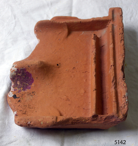
Tile, c 1914
This clay roof tile was part of the ANTARES cargo, a large consignment of tiles on its way to Melbourne. THE ANTARES In mid-November 1914, after the beginning of the First World War, a young local man went one evening to fish near the Bay of Islands, west of Peterborough. He later arrived home hurriedly and in an agitated state declaring: "The Germans are coming!" His family laughed and disbelieved him, as this young fellow was prone to telling fictional tales. About a month later, on December 13th 1914, local farmers Phillip Le Couteur and Peter Mathieson were riding in the vicinity, checking on cattle. Phillip Le Couteur saw what he “thought was the hull of a ship below the cliffs.” He rode to Allansford and contacted police. The next day, two Constables and Phillip Le Couteur returned to the site, where they dug a trench near the top of the cliff and sank a log in it. To this they attached a rope, which they threw down the cliff face. Constable Stainsbury and Phillip Le Couteur then made the dangerous descent down the rope on the sheer cliff face. They found wreckage strewn around a small cove and a portion of a man's body under the cliffs. The hull of the ship could be seen about 300 metres out to sea. Some of the wreckage revealed the name Antares and the remains of the ship's dinghy bore the name Sutlej. During the next two weeks and with the help of the Warrnambool lifeboat and crew, two more bodies were found. Later investigations proved that the tragic wreck was indeed that of the Antares, reported overdue on the 207th day of her voyage from Marseilles, France, to Melbourne. She was a three masted, 1749 ton iron clipper, built in Glasgow in 1888 and originally named and launched as the Sutlej. Bought in 1907 by Semider Bros. from Genoa, Italy, she was refitted and renamed Antares. It was later realised that the local lad who a month earlier had declared he had seen German guns being fired, had probably seen distress flares fired from the deck of the Antares the night she was wrecked. She was last sailed under Captain Gazedo and wrecked at what is now known as Antares Rock, near the Bay of Islands. She had been carrying a large cargo of roof tiles from France to Melbourne, consigned to Mullaly & Byrne. Many of them are now to be seen amongst the battered and scattered remains of the wreck. Some of the timbers were found to be blackened by fire. An Information Board has been erected on the cliff top near to the site of the Antares wreck, at the end of Radfords Rd, west of Peterborough. (Ref: Flagstaff Hill Maritime Village’s “Antares” fact sheet, Victorian Heritage Database, Information Board at Peterborough, Flagstaff Hill Significance Assessment 2010) The Antares was one of the last of the 'tall ships' to be lost along the south west coast of Victoria, and is the only wreck that took the lives of all people on board. She is listed on the Victorian Heritage Register VHS S34. The Antares is significant as a sail trader carrying an international inbound cargo. It is part of the Great Ocean Road Historic Shipwreck Trail. Piece of a clay roof tile recovered from the wreck of the Antares. Has a relief of a horse on back. Artefact Reg No A/7.flagstaff hill, warrnambool, shipwrecked-coast, flagstaff-hill, flagstaff-hill-maritime-museum, maritime-museum, shipwreck-coast, flagstaff-hill-maritime-village, antares, tall ship, peterborough, 1914 shipwreck, phillip le couteur, peter mathieson, constable stainsbury, sutlej, antares rock., bay of islands, clay tile, roofing tile, roof tile -
 Flagstaff Hill Maritime Museum and Village
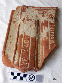
Ceramic - Roof Tile, c 1914
This terracotta clay roof tile was part of a consignment of tiles in the cargo of ANTARES. THE ANTARES In mid-November 1914, after the beginning of the First World War, a young local man went one evening to fish near the Bay of Islands, west of Peterborough. He later arrived home hurriedly and in an agitated state declaring: "The Germans are coming!" His family laughed and disbelieved him, as this young fellow was prone to telling fictional tales. About a month later, on December 13th 1914, local farmers Phillip Le Couteur and Peter Mathieson were riding in the vicinity, checking on cattle. Phillip Le Couteur saw what he “thought was the hull of a ship below the cliffs.” He rode to Allansford and contacted police. The next day, two Constables and Phillip Le Couteur returned to the site, where they dug a trench near the top of the cliff and sank a log in it. To this they attached a rope, which they threw down the cliff face. Constable Stainsbury and Phillip Le Couteur then made the dangerous descent down the rope on the sheer cliff face. They found wreckage strewn around a small cove and a portion of a man's body under the cliffs. The hull of the ship could be seen about 300 metres out to sea. Some of the wreckage revealed the name Antares and the remains of the ship's dinghy bore the name Sutlej. During the next two weeks and with the help of the Warrnambool lifeboat and crew, two more bodies were found. Later investigations proved that the tragic wreck was indeed that of the Antares, reported overdue on the 207th day of her voyage from Marseilles, France, to Melbourne. She was a three masted, 1749 ton iron clipper, built in Glasgow in 1888 and originally named and launched as the Sutlej. Bought in 1907 by Semider Bros. from Genoa, Italy, she was refitted and renamed Antares. It was later realised that the local lad who a month earlier had declared he had seen German guns being fired, had probably seen distress flares fired from the deck of the Antares the night she was wrecked. She was last sailed under Captain Gazedo and wrecked at what is now known as Antares Rock, near the Bay of Islands. She had been carrying a large cargo of roof tiles from France to Melbourne, consigned to Mullaly & Byrne. Many of them are now to be seen amongst the battered and scattered remains of the wreck. Some of the timbers were found to be blackened by fire. An Information Board has been erected on the cliff top near to the site of the Antares wreck, at the end of Radfords Rd, west of Peterborough. (Ref: Flagstaff Hill Maritime Village’s “Antares” fact sheet, Victorian Heritage Database, Information Board at Peterborough, Flagstaff Hill Significance Assessment 2010) The Antares was one of the last of the 'tall ships' to be lost along the south west coast of Victoria, and is the only wreck that took the lives of all people on board. She is listed on the Victorian Heritage Register VHS S34. The Antares is significant as a sail trader carrying an international inbound cargo. It is part of the Great Ocean Road Historic Shipwreck Trail.Part of a terracotta roof tile from the wreck of the Antares Has sand encrusted to bottom of tile. Artefact Reg No A/6.flagstaff hill, warrnambool, shipwrecked-coast, flagstaff-hill, flagstaff-hill-maritime-museum, maritime-museum, shipwreck-coast, flagstaff-hill-maritime-village, antares, tall ship, peterborough, 1914 shipwreck, phillip le couteur, peter mathieson, constable stainsbury, sutlej, antares rock., bay of islands, terracotta tile, roof tile, clay tile, roofing material, building material -
 Flagstaff Hill Maritime Museum and Village
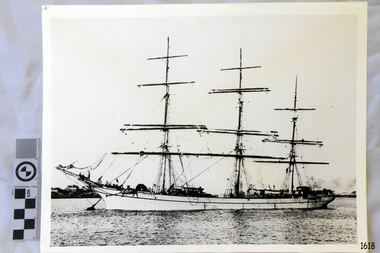
Photograph, 1907-1914
This photograph is of the sailing ship ANTARES at full sail, taken between 1907, when she was named ANTARES, and 1914, when she was wrecked.. THE ANTARES In mid-November 1914, after the beginning of the First World War, a young local man went one evening to fish near the Bay of Islands, west of Peterborough. He later arrived home hurriedly and in an agitated state declaring: "The Germans are coming!" His family laughed and disbelieved him, as this young fellow was prone to telling fictional tales. About a month later, on December 13th 1914, local farmers Phillip Le Couteur and Peter Mathieson were riding in the vicinity, checking on cattle. Phillip Le Couteur saw what he “thought was the hull of a ship below the cliffs.” He rode to Allansford and contacted police. The next day, two Constables and Phillip Le Couteur returned to the site, where they dug a trench near the top of the cliff and sank a log in it. To this they attached a rope, which they threw down the cliff face. Constable Stainsbury and Phillip Le Couteur then made the dangerous descent down the rope on the sheer cliff face. They found wreckage strewn around a small cove and a portion of a man's body under the cliffs. The hull of the ship could be seen about 300 metres out to sea. Some of the wreckage revealed the name Antares and the remains of the ship's dinghy bore the name Sutlej. During the next two weeks and with the help of the Warrnambool lifeboat and crew, two more bodies were found. Later investigations proved that the tragic wreck was indeed that of the Antares, reported overdue on the 207th day of her voyage from Marseilles, France, to Melbourne. She was a three masted, 1749 ton iron clipper, built in Glasgow in 1888 and originally named and launched as the Sutlej. Bought in 1907 by Semider Bros. from Genoa, Italy, she was refitted and renamed Antares. It was later realised that the local lad who a month earlier had declared he had seen German guns being fired, had probably seen distress flares fired from the deck of the Antares the night she was wrecked. She was last sailed under Captain Gazedo and wrecked at what is now known as Antares Rock, near the Bay of Islands. She had been carrying a large cargo of roofing tiles from France to Melbourne, consigned to Mullaly & Byrne. Many of them are now to be seen amongst the battered and scattered remains of the wreck. Some of the timbers were found to be blackened by fire. An Information Board has been erected on the cliff top near to the site of the Antares wreck, at the end of Radfords Rd, west of Peterborough. (Ref: Flagstaff Hill Maritime Village’s “Antares” fact sheet, Victorian Heritage Database, Information Board at Peterborough, Flagstaff Hill Significance Assessment 2010) The Antares was one of the last of the 'tall ships' to be lost along the south west coast of Victoria, and is the only wreck that took the lives of all people on board. She is listed on the Victorian Heritage Register VHS S34. The Antares is significant as a sail trader carrying an international inbound cargo. It is part of the Great Ocean Road Historic Shipwreck Trail. Photograph of the three masted fully rigged Antares at anchor. (ref: Ships A-B SH016.)flagstaff hill, warrnambool, shipwrecked-coast, flagstaff-hill, flagstaff-hill-maritime-museum, maritime-museum, shipwreck-coast, flagstaff-hill-maritime-village, antares, tall ship, peterborough, 1914 shipwreck, phillip le couteur, peter mathieson, constable stainsbury, sutlej, antares rock., bay of islands -
 Melton City Libraries
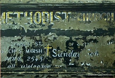
Photograph, Signboard, 1972
Edna Barrie handwritten notes – copied 18th October 2013 web The early story of the Wesleyan Methodist Church in Victoria At Melton between Bal [Ballarat] and Melb [Melbourne] was introduced by the Revd Wlm Blamires in 1862 ably seconded by the late Mrs Westlake (afterwards Mrs Spargo). Mr J James, the active and indefatigable Revd Eb Taylor and such workers as Atkinson Corr and Ferris. Mawson and John Dare 1867 the foundation stone of the present church was laid. Revd D Waugh 1867. Melton and Toolern Vale have benefited by the generous help of Mr J Browne esquire of White Hills Station Diggers Rest and are now comprised in the Sunshine Circuit. Written at a later date – Wesleyan 16-4-1867 then Methodist 3-10-1867. Bluestone building cost Lsd 350-13-6. Seating 40 pounds Rev Ken Moore Methodist opened at Brooklyn Rd Melton South c1940 closed c 1972. Timber Church shifted from Staughton Vale, prior to this Services held in Victoria Hall Melton South. The source of the information – ? and date notes were made On the Chart outlining Melton Churches the following additional notes- At opening (nil Plaster, nil ceiling) Slate roof. Closed 1910-1911- most likely from 1867 Express My research - Melton Express noted 15th Aug 1939 porch added to Church at Melton South making the date earlier than 1940. Photographs taken when the building was being used as the UC Opp Shop and demolition of the building showing the porch. Charles Ernest Barrie was prominent in the life of the Methodist Church and established a thriving Sunday School. He built the Chaff Mills at Melton South in 1900. In 1910 he sold the Mill to Glover Onians and moved to a farm at Trundle NSW, where he lived for about a year. In May 1911 he purchased “Darlingsford” in Melton when it came on the market. The address Elizabeth St Moonee Ponds appears in the family records during this period and during WW 1 they also lived at Ascot Vale where the Lang parents lived. On returning after the war to Melton to occupy the Darlingsford house, which had been occupied by a caretaker. The family joined the Presbyterian Church. Evidenced in the Church Minute Book. 1920 What happened to the Methodist Church between 1910 – 1920? How long did it exist while in the Bluestone building in Palmerston St (Heritage listed 2008) When did the church commence in Victoria Hall? Built 1910 on land donated by C E Barrie. I attended the Methodist Church Melton Sth when monthly services were held in the afternoons. We were members of the Presbyterian Church and also supported the Melton Sth Church during the 1950’s Signboard from Melton South Methodist Churchchurches -
 Flagstaff Hill Maritime Museum and Village
Photograph - Portraits, c. 1904
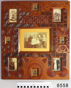
Ann Dale (nee Lees) was given this frame by her younger brother Thomas Chamberlain Lees, who was eighteen at that time. Thomas was the youngest son and seventh child of Lees and Sarah (nee Chamberlain) Lees. Ann loved her little brother’s artistic talents, which are demonstrated in this frame he designed and carefully carved for her. Thomas had cleverly finished the back with timber pieces around the images, and a section of a 1904 calendar. His “GOOD LUCK” is below the image of Ann, her husband Ellis Dale and their five children, c 1900. Sadly, Thomas died in 1911, aged 25. Ellis Dale’s father, William, was a quarryman who sailed from Yorkshire to Australia in 1852. He later bought land for Dale’s Quarries on the edge of Warrnambool in the area of Dale and Aberline roads. From the age of about eleven, Ellis and his brother worked in the quarry beside their father. In 1890 Ellis Dale married Ann Lees. Ann had lived nearby at Wangoom with her parents, Lees and Sarah Lees, who had had her photograph taken when she was a little girl, wearing her black dress. Ellis built a bluestone cottage for himself and Ann on his father’s land in Dales Road. He later added weatherboard rooms, and they named their finished home “Latrigg”. Early in their marriage Ellis recycled some empty dynamite boxes from their quarry to build a cupboard with drawers for Ann’s flat irons and other ironing equipment. The cupboard was used by future generations until recently, when Ann’s granddaughter, Betty Stone, donated it as part of the Chamberlain Dale Lees Collection. It is now in the kitchen of the Port Medical Office. Chamberlain Dale Lees family – local Colonial Pioneers Centre: Ellis Dale and Ann (nee Lees) and their five children - c 1900. Sons lvor William, Robert Ellis, Alfred John, and daughters - Elsie Mary Dale, and Daisy Elvena Dale. Top Left: Ann Lees - c 1868, (the little girl in the black dress) Top Right: William Dale Jnr. and Ellis Dale - c 1871 Lower Left: Ellis Dale and Ann (nee Lees), married 22 Jan. 1890 Lower Right: William Dale Jnr. and Agnes (nee Gillies), married 1883 Oval Photographs: unidentified but presumed to be family members [NB Spelling of Ann Dale – The spelling of Ann’s name has been confirmed by Betty Stone as being “Ann” (Not Anne), by phone conversation with Flagstaff Hill Maritime Village, K P 14th April 2014] (Note: For additional information please refer to Betty Stone’s book “Pioneers and Places - A History of three Warrnambool Pioneering Families” ie. Chamberlain, Dale and Lees Families)This item is associated with the families of Chamberlain, Dale and Lees. These families are listed in the "Pioneers' Register" for Warrnambool Township and Shire, 1835-1900, published by A.I.G.S. Warrnambool Branch. The handmade frame is a unique example of clever craftsmanship and carving skills used by early pioneers with limited access to materials.Family photographs, nine, set into carved, solid wood frame, stained and lacquered. Carving includes leaves, flowers, a horseshoe and a ribbon with the words "GOOD LUCK" Photographs are of the Lees family of Wangoom, from the 'Chamberlain Dale Lees Collection’ Made by Thomas Lees for his sister, Ann. The little girl with black boots on is Betty Stone's grandmother. The back of the frame has a London calendar dated 1904.Words in carved ribbon "GOOD LUCK" Calendar for the year 1904flagstaff hill, warrnambool, shipwrecked coast, flagstaff hill maritime museum, maritime museum, shipwreck coast, flagstaff hill maritime village, great ocean road, chamberlain, dale, lees, stone, betty stone, warrnambool pioneers, thomas lees, wangoom, ann dale, ellis dale, flagstaff hill, warrnambool, shipwrecked coast, flagstaff hill maritime museum, maritime museum, shipwreck coast, flagstaff hill maritime village, great ocean road, chamberlain, dale, lees, stone, betty stone, warrnambool pioneers, thomas lees, wangoom, ann dale, ellis dale, thomas chamberlain lees, handmade photograph frame, carved photograph frame, dynamite -
 Bendigo Historical Society Inc.
Document - CORNISH COLLECTION: DOCUMENTS RELATED TO VARIOUS CORNISH ENTERPRISES IN BENDIGO
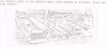
Documents and copies of photos related to various Cornish enterprises in Bendigo: a. Line drawing (faint) of foundry owned by the Roberts family (Mitchell, Wills and King streets); b. copy of article from unknown source re United Iron Works with details of the firm and Roberts principals - William Roberts, Abraham Roberts and Arthur Roberts - with copies of photographic portraits (Bartlett Bros.) - bad copy with LH side of text partly illegible; c. copy of article titled 'Goyne's Battery Gratings re John Goyne and history of the business (submitted by person living at ''Rosemundy'', Goynes Road, Epsom - Goyne's home then on 20 acres); d. Photograph of old Robinson photo of Bendigo Stamper Grating Factory, Epsom and five men posed in front of large timber building (badly cut photo with LH edge missing. original photo (9 x 13) of ''Former Bendigo Cornish Fuse Factory'' (handwritten inscription on reverse) taken in recent times (hint - car in driveway); f. copy from un-named book of J Nankervis's Ham and Bacon Curing Factory, Golden Square - drawing of the establishment and a photos of winning display of small goods at the Bendigo Show (no date); g. copy from un-named book of photo of premises of A J Williams, Lily and McKenzie Streets - wooden structure with sign indicating Hardware Merchants and ??Mines Furnisher?? , showing three horse-driven small wagons (delivery?); h. copy of photo of Cornish store(1880s) at White Hills - mention of Frederick Stuckenschmidt (married Miss Mary Smith), William Mathews (original owner?) - corner brick building with family posed outside alongside horse and light cart;. reproduction of exhibit in Bendigo Spring Show, 1915 , the ''Made in Bendigo Exhibition'' - first prize awarded to Messrs H M Legg & Co. Progress Jams, preserves, tomato sauce, tomatoes products, candied peels etc. (folded and small tear).bendigo, buildings, early bendigo businesses, bendigo stamper grating factory. epsom. j. nankervic ham and bacon curing establishment. golden square. bendigo cornish fuse factory. cornish stores. messrs h. m. leggo and co. abraham roberts. arthur roberts. william roberts. goyne's battery gratings. -
 Federation University Historical Collection
Book, Final recommendations Ballarat Study Area Land Conservation Council, Victoria, 1982, 1982
Yellow soft covered report of 95 pages . The contents of the report include: Parks, reference areas, wildlife reserves, water production, hardwood production, softwood production, flora Reserves and Flora and Fauna reserves, bushland reserves, historic area and reserves, rivers and streams, Roadside conservation and Highway parks, Education areas and School Plantations, Lake Reserves, geological reserves, recreation, scenic reserves, agriculture, mineral and stone production, utilities and survey, township land, Uncommitted Land, military training, other reserves and public land. Maps include: The Study area 1: 250 000 Supplementary Mapsland conservation authority, ballarat, endowment plantations, pine plantations, langi ghiran state park, mount buangor state park, enfield state park, ballarat-creswick regional park, rossbridge, black lake, flax mill swamp, dereel lagoon, lake bolac, lake wongan, langi ghiran reservoir, gong gong reservoir, pincotts reservoir, beales reservoir, wilsons reservoir, moorabool reservoir, korweinguboora, korweinguborra reservoir, learmonth bores, sago hill, illabarook reservoir, ballarat water commission, dunneworthy, mount cole, mont lonarch, ben major, waterloo, trawalla, linton, ross creek, canadian, shepherds flat, lal lal, mount doran, raglan, chute, carngham, buninyong, watsons hill, enfield, cape clear, illabrook, rokewood junction, mount warrenheip, nerrina, jubilee, golden stream, australasian deep lead mine, happy valley school, piggoreet, berringa, bulldog, ballarat common, wildlife, water, timber, flora, rivers, geology, agriculture, warrenheip, biodiversity -
 Flagstaff Hill Maritime Museum and Village
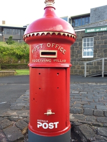
Functional object - Post Office Receiving Pillar, 1885
Post Office Receiving Pillar was Collected from Warrnambool City Council’s Scott Street Depot and transported to Flagstaff Hill, stored in the Barracks area Friends of Flagstaff Hill began the project of restoring the Post Office Receiving Pillar in early 2011. The replacement dome required a pattern to be made from paper, then timber, then someone to manufacture it. The cast iron body required sand blasting and undercoating. The pillar was installed in Flagstaff Hill Maritime Village in March 2014. A specialist visited the Village and painted the pillar with 7 coats of ‘post office red’ then completed the job with gold paint on the details. In 2015 an information plate of brass was fitted to the Pillar in the position that would have originally announced the clearing times. It was originally manufactured by G Couch, Engineer, Alliance Iron Works, Melbourne. Gordon Couch passed away in June 1896 and his Works were offered for auction in November 1897. HISTORY OF POST OFFICE RECEIVING PILLARS In 1851 ‘pillar boxes’ were installed at roadside locations in the island of Jersey, England; they had already been successful in several European countries. The use of new prepaid, adhesive postage stamps as well as the roadside pillar boxes meant there was no need for the public to take a trip to the Post Office just to post a letter. By 1855 London had installed its first six Pillar Boxes. In 1856 the pillar boxes were first introduced in Sydney. These were circular with a crown on the dome, supported by leaves. Early Victoria Mail was originally collected by ‘letter carriers’, first appointed in Melbourne in 1841, equipped with leather bag and hand bell. He wore a red coat with brass buttons and a black top hat! In 1844 two wooden receiving boxes were erected in Melbourne. The first cast iron boxes were installed in South Melbourne (Emerald Hill) and were still in service until 1967. They were a fluted circular design and made in England. In the early 1860’s the ‘low door round’ design posting box was introduced, being circular and surrounded by a crown, with two broad embossed bands around its circumference. The clearance door was in front of the box and low down. These were made in Australia. In the early 1870’s square boxes with a tapering top were being used. These too were made in Australia by different manufacturers with slight variations on style such as the orientation and number of slots. Next came the circular boxes again, similar to the ‘low door round’ but with the clearance door extending to just below the posting slot, often referred to as ‘high door round’. These boxes did not have embossed bands. In 1887 small cast iron boxes were introduced, attached to posts and poles and called ‘lamp post receivers’. Around 1930 a ‘London’ model was used in Victoria. It was copied from the flat-domed type in London but made in Tasmania. … [References: Flagstaff Hill Maritime Village records, The Argus, 11th April, 1890, The Argus, 2nd July, 1896, The Argus, 30th Nov. 1897, “Stamps.Au” http://www.stampsau.com, 4th April 2011 (Extracted from “Australian Street Posting Boxes” by Ken Sparks – out of print)] Post Office Receiving Pillar, or letterbox.1885 "High Door Round" design, restored 2014 Tall cast iron sylinder with decorative dome cap, slot in side, hinged door with handle shaped as a fist. Painted red with gold trip..Reconditioned barrel, reconstructed dome. Restored by Friends of Flagstaff Hill, 2014. Now a working letterbox. Made in Melbourne.Oval maker's plate “ - G. COUCH - / ENGINEER / ALLIANCE IRON / WORKS / MELBOURNE”flagstaff hill, warrnambool, shipwrecked coast, flagstaff hill maritime museum, maritime museum, shipwreck coast, flagstaff hill maritime village, great ocean road, post office receiving pillar, letterbox, mailbox, australia post -
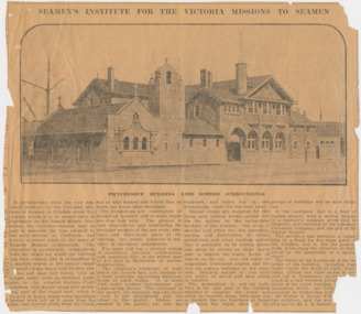 Mission to Seafarers Victoria
Article, Herald, Seamen's Institute for the Victoria Missions to Seamen, 30 August 1917
SEAMEN'S INSTITUTE FOR THE VICTORIA MISSIONS TO SEAMEN In architectural style, the new Seamen's Institute for the Victorian Missions to Seamen, in Flinders street Extension which is to be opened early in September by Sir Ronald Munro Ferguson, the Governor-General, may be said to resemble the type adopted by the early settlers in California, and known in recent years by the name of Spanish Mission architecture. This character is particularly sympathetic with the object for which the building has been erected, and is exemplified in a marked degree in the unique chapel tower of oblong shape with its four pinnacles and open bell turret, with an almost rustic cross as terminal point: also in the arcaded Eastern Court cloisters, with simple round arch arcading, and in the chapel roof, which is framed of heavy rough-hewn hardwood timber work left as it came from the saw, and erected green from the forest. but so well framed and bolted that no harm can result from shrinkage. The foundations are constructed of reinforced concrete, and in some places are nine feet wide. The ground is very treacherous, and considering the irregular weights of the one story, two-story, and three-story parts of the building, the result achieved in sta bility is eminently satisfactory. The main hall has a vaulted ceiling of reinforced concrete construction, and, spanning 35f., is the widest span of any floor in Melbourne of similar construction. The chaplain's residence is built above the lecture hall, and consists of a most complete, up-to-date dwelling-house of eight rooms. It is fitted with every modern convenience and labor-saving device. The cupboard in the pantry, for instance, has two faces — one in the diningroom and the other in the pantry. Dishes are washed in the pantry, put into the cupboard, and taken out in the diningroom, ready for the next meal. Special rooms are designed for the many and various works carried out for the sailors by the industrious workers of the mission. One room is shelved and fitted for the reception, sorting, and distribution of books, periodicals, and other reading matter that is parcelled up by willing hands and given to sailors as ships leave port, to beguile the weary hours of leisure on the sea. Any old books or magazines, illustrated papers, and the like are always welcome at the insti tute. Reading matter of this kind can easily be saved and sent along in bundles. The gymnasium is not yet built. This is the only part of the building required to complete the block; and when its concrete dome, with open eye at summit like the Pantheon at Rome is erected, the whole effect of the groups of buildings will be most striking. In the entrance hall is a floor of marble mosaic, with a central feature of a mariner's compass seven foot in diameter, well executed by the Adamant Pavement Company, and the gift of Mr George Russell. The architect has designed a copper ship as a finial for the main gable of the building, and it, like the gymnasium, is awaiting the collection of more funds or the generosity of a special donor. The whole of the woodwork of the in terior of the building, including high dados round the walls of halls, stair cases, billiard and other rooms is car ried out in Tasmanian hardwood, fin ished in a dull beeswax polish, and the floors of the entire building, except the lavatories, which are tiled, are also executed in Tasmanian hardwood. Mr Walter R. Butler, F.R.I.B.A., was the architect, and the work was carried out by Mr A. B. Robertson, builder. PICTURESQUE BUILDING AMID SOMBRE SURROUNDINGSThe article gives a valuable description of the Mission at the end of its construction and before its opening.4 columns article with photograph of the front of the Missionlady fraser, walter richmond butler (1864–1949), architecture, spanish mission, california, reinforced concrete, tasmanian hardwood, gymnasium, norla dome, pantheon, adamant pavement company, george russell, compass, finail, weathervane, chaplain's residence, manse, chapel, courtyard, cloisters, main hall, spannig -
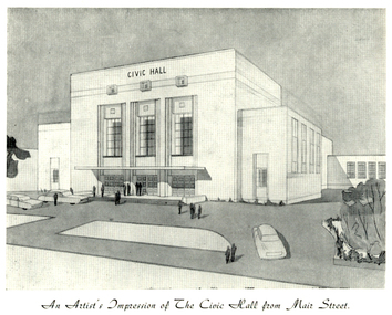 Federation University Historical Collection
Programme, The Opening of Civic Hall, 1956, 1956
The City of Ballarat unanimously resolved to erect a Civic Hall in Mair Street in 1951. The architects, Gordon Murphy, of Melbourne, and H.L. and L.J. Coburn, of Ballarat, were commissioned in 1952. The Council constructed the foundations and footings for the building under the supervision of the former City engineer, Mr L.H. Finch, in 1953. These footings are of massed concrete. The design for the building took advantage of the cross fall of the land, providing for the Small Hall to be entered from the Doveton Street frontage through a foyer under the Main Stage, the structure is steel with brick panels, with accommodation for 1,592 persons in the Main Hall and 440 persons in the Lower Hall. The front facade faces Mair Street, set back from the building line to provide for the entrance drive-ways and kerbed gardens. Tenders were invited on a firm price basis. A young Ballarat master Builter, Walter Benbow Trahar was the successful tenderer, the contract price being 139,841 pounds. the work was commenced in 1953 and has proceeded in spite of material and labour difficulties until its completion. The following statistics are of interest:- * The foundations contained 200 cubic yards of concrete. * The constructional steel work weighs approximately 270 tons. * The reinforcing steel 47 tons. * Reinforced concrete in the structure, 1,100 cubic yards. * The approximate number of bricks in the building, 580,000. * The flooring is of selected kiln-dried hard wood and totals 40,000 lineal feet. * The dimensions of the Main Auditorium, 100ft by 86 ft, including the side promenades each 82ft by 13ft. *The Main stage, of reinforced concret with parquette finish measures 62 ft by 40ft. *The floor area of the Lower Hall is 74 ft by 38 ft, and has a stage dimensions of 40ft by 20 ft. * Each hall has independent heating and ventillating systems. Where possible the material in the building was furnished from local business houses. The public address installation, which provided for additional microphones, is on the main Stage. There is inter-communication throughout the building connecting the front office, with the bioscope box, the stages in both the large and lower halls, and the Hallkeeper's residence. Local craftsmen have completed the painting, plaster work, and the electrical installation; local produced materials being used in the construction of the buildings with the exception of the timber for the Main Floor, the roofing and the structural steel. The City of Ballarat Councillors in 1956 were Councillors N. T. Callow, F.J. Cutts, K.C. Webb, W.E. Roff, O.W. Curnow, F.T. Woodward, Allan C. Pittard, A.W. Nicholson, J.A. Chisholm, G.L. Scott, F.W. Oliver, A.D. Mason. The Town clerk was H.R. Maddern and the City Engineer was G. Murrowood. A City of Ballarat Council meeting of 25 September 2013 voted to demolish the Ballarat Civic Hall. The Council heard from nearly 50 members of the public during a marathon six-hour meeting. Councilors John Birt, Des Hudson, Amy Johnson, Josh Morris, Peter Innes, John Philips supported the motion to demolish Civic Hall. Councillors Samantha McIntosh, Vicki Coltman and Belinda Coates voted against the motion.Six page souvenir Program of citizens' entertainment on the occasion of the Opening of Ballarat Civic Hall on in August 1956. The front cover features the City of Ballarat Coat of Arms. The programme starts with a message from the Mayor, Cr Neil T. Carrow. It includes the Concert Programme directed by James H. Davey, an asrtist's impression of the Civic Hall from Mair Street, and information relative to the New Civic Hall. The programme features images of the City of Ballarat Coat of Arms, Cr N.T. Callow, , James H, Davey, and an artist's impression of the Ballarat Civic Hall. Mayor Neil Callow's Message: "To-day, our citizens witness the fulfilment of the most extensive Municipal undertaking in the City's period of recent prosperity and development. Their Hall now fills a requirement of which they have been deprived since the Coliseum building was destroyed by fire over 20 years ago. The building has been designed as an all purpose structure and I am hopeful the citizens will use it and enjoy it to its fullest extent. Your Council and its Architects have planned as broadly as possible for the benefit of all to-day and for years to come. We are proud of the work executed by a Ballaarat Master Builder whose work is a monument to the City's craftsmen. I feel I should also remind this assembly that the women of Ballaarat, back in 1951, provided funds which have been applied in the purchase of a Grand Piano and two Upright Pianos which are now installed in this building. The sincere hope of myself and your Councillors is that this Hall and its amenities will prove of immense value to the development of the cultural and artistic tastes of this community and that it will be freely used for these and many other purposes. From now on this magnificent building and its furnishings and equipment will be available to all. I strongly exhort you to use and protect it. My hope is that the citizens will, for many years to come, enjoy the amenities which it has to offer. ballarat civic hall, civic hall, architecture, finch, art deco, city of ballarat, coat of arms, city of ballarat coat of arms, callow, shugg, lemke, oates, gullan, tuuri, john, robertson, sorrell, antonio, gordon murphy, walter benbow trahar, trahar, coburn, h.l. coburn, l.j. coburn, n.t. callow -
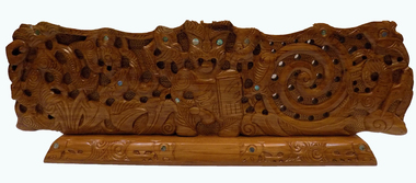 Geoffrey Kaye Museum of Anaesthetic History
Sculpture - Carving, Heke Collier, Mauri Ora, May - July 2016
Professor Alan Merry commissioned the work from New Zealand artist Heke Collier as a gift to the College at his retirement from Council. This artwork was carved by Heke Collier in May-July 2016. It is made from native New Zealand Rimu timber. Heke named this carving Mauri Ora which translates to vitality, well-being or the healing life-force. Tihei Mauri Ora (breath of life) is a well-known Māori saying that was uttered by the first human being. Māori believe that all people and all things have mauri. This carving symbolises the many shapes and forms of mauri with reference to the Māori creation story, and the spiritual and natural worlds. Māori refer to the heavens as Ranginui the sky-father and according to the Māori creation story, Ranginui was pressed against Papatūānuku the earth mother. Their children did not like living in the cramped, dark space between them. One of their sons Tāne separated Ranginui and Papatūānuku to allow light and life into the world. The central male figure carved into Mauri Ora (above) is Tāne. To his right (far right) is his mother Papatūānuku and to his left (far left) is his father Ranginui. Papatūānuku gives birth to all things including human kind and provides the physical and spiritual basis for life. The takarangi (spiral) design in the carving (to the left of Tāne) symbolises the life cycle. Whenua, the word for land also means placenta - organ that nourishes the baby in the womb. Women are associated with the land (whenua) because the land gives birth to people and so do women. In tribal history women have had influence over land and men. Papatūānuku is depicted in the carving to the right of Tāne. Ranginui played a pivotal role in the birth of the sun, moon, planets, stars and constellations – collectively called Te Whānau Mārama (the family of light). Human life and knowledge were said to originate in the realm of Ranginui. Tāne ascended the heavens to retrieve three baskets of knowledge: te kete-tuatea (basket of light), te kete-tuauri (basket of darkness) and te kete-aronui (basket of pursuit). Ranginui is depicted in the carving to the left of Tāne. Tāne had many different roles, and he was given different names to reflect these roles. He is called Tāne-mahuta as god of the forest, Tāne-te-wānanga as the bringer of knowledge, and Tāne-te-waiora as the bringer of life, prosperity, and welfare. His teachings and knowledge are relevant in contemporary times, and the cell-phone carved into his left hand represents this. Tuatara feature in the Māori creation story and some tribes view Tuatara as kaitiaki (guardians) of knowledge. Given that they have lived for more than 220million years. There are birds or manu surrounding Tāne in the carving, who represent Tane’s voice or the voice of the forest. The flax or harakeke depicted in the carving represent the family unit and reinforce the importance of kinship ties. There are plants, ferns, and birds carved into Mauri Ora play an integral role in the life-cycle which represent rongoa Māori or Māori medicine. Traditional Māori carving in Rimu, a native New Zealand wood, with paua insets.merry, alan, anzca council, collier, heke, kaiwhakairo, master carver, rimu -
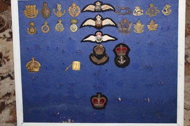 Lara RSL Sub Branch
framed embroaded Patches & Brass military Medals, Blue material background Framed Patches & Medals
Some are rare in natureBlue material - background, White timber frame surround with 18 metal military cap badges and 6 military cloth patches., Row 1 British Army Cap Badge - Royal Army Ordnance Corps. F1 Household Life guards, Cap Badge, Center G.R. below V. Oval with motto on outside Banner. Royal Lancashire Cap Badge.World War 1 R.F.C. - Royal Flying Corps Cap Badge. surrounded by Laurel Wreath with Crown on top. Circ. 1895 Royal Australian Air Force pilot's wings. The brevet has white cotton embroidered wings, a king's crown, and the letters 'R.A.A.F.' within a pale blue embroidered laurel wreath. Horse Badge - Small Brass - British Army Military. Saint George slaying he dragon - Small Brass Badge. Army Cyclist Corps - World War 1 Cap Badge. Duke of Wellington's Regimental Cap Badge. Row 2 Royal Inniskilling Fusiliers Corps 1895 = Shoulder Title - Officer's. Royal Horse Guards Brass Army Cap Badge. Brass Badge - Queen; Mary's Own - 18th Hussars. Vintage Royal Welsh Fusiliers Cap Badge. R.A. F. Service Dress Wings with King's Crown. American Eagle Brass - Army Officers Cap Badge. 45th Overseas Battalion - Canada Expeditionary Forces. 48th Battlion, Victoria, Canada - British Columbia Brass Cap Badge. World War 1. Row 3. Center World War 11 - Rhodesian Air Force Cloth Pilots wings . row 4 Center - Embossed Woven Crown with metal gold thread woven feathers under. Right - Embossed Woven Crown with Brass Gold Anchor below.- Navy Petty Officer Cap Badge. Row 5. Large Metal Gold color Crown - British Army Warrant Officers Badge. Small Brass Single Rifle with ACT on the Butt of the rifle. Brass Badge - Drummers Proficiency., Last Row - center Embossed woven Crown Red Felt on Blue Back.none - no labels6 cloth patches raised and embossed, 18 military brass metal cap badges vary in type and country and conflict. -
 Ballarat Tramway Museum
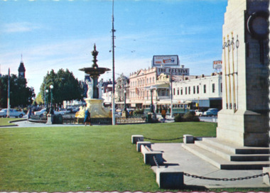
Postcard, Nucolorvue postcards - Bendigo
Series of six (6) Nucolorvue postcards with serrated edges of scenes around Bendigo featuring Bendigo trams under the operation of either the SECV or the Bendigo Trust. 963.1 - "The Cenotaph and Alexandra Fountain" at Charing Cross. Has Bendigo bogie car in background. Also the Beehive building and Ezywalkin shoes. Nucolorvue postcard BE41 on rear and other information in green ink. 963.2 - "Tram No. 25, a maximum traction car built in 1916. Now operated by The Bendigo Trust between Central Deborah Mine and Emu Point." Features No. 25 in Bendigo Trust colours with Coca Cola and Bendigo Timber Co ads on the roof. On nearby pole is a "Bendigo Talking Vintage Tram" signs. In background is the Beehive building and other buildings near Charing Cross. Nucolorvue postcard BE52 on rear and other information in green ink. 963.3 - "Birney Tram No. 30 decorated for a Royal Tour occasion. The Bendigo trust operates this tram and others on a tourist service between Central Deborah Mine and the Chinese Joss House at Emu Point." Features No. 30 decorated for a visit of Prince Charles, 26/10/1974 with crown, Australian and English flags. Has Myer building in the background. On adjacent pole are two signs "Cars stop on Request". Nucolorvue postcard BE 44 on rear and information in green ink. 963.4 - "The Central Deborah Gold Mine and a vintage tram operated by the Bendigo Trust" Features Birney No. 28 at the mine terminus. Nucolorvue postcard BE48 on rear and other information in green ink. 963.5 - "Charing Cross Bendigo Vic." featuring SECV trams 5, 19 and other bogie car crossing street heading for Quarry Hill. Has Fountain Plaza building in background. Nucolorvue and other information in brown ink. 963.6 - "The Sacred Heart Cathedral looking from High St." Has tram 25 in Bendigo Trust colour running along street in front of Cathedral. Work to complete the spire on the Cathedral underway. Nucolorvue postcard BE47 and other information on rear in green ink. Bendigo Vintage Talking Trams - K.S.Kingstrams, tramways, bendigo, the bendigo trust, charing cross, royal visit, tram 37 -
 National Wool Museum
Photograph - C. Glover and Sons Pty. Ltd, 1890-1944
C. Glover and Sons Pty. Ltd. was founded on Brougham Street, Geelong c.1870. They operated as a wool and sheepskin storeroom situated on both sides of Brougham Street; where the current Elders building is located. The store was owned and operated by Joshua Glover with his brother Cyrus. A third brother Arthur also worked at the store. It was a very successful business and employed up to 40 men at its peak. Cyrus Glover died quite young, around 54, with his son Howard taking his place in the partnership at 23. During the Second World War the business was requisitioned by the Australian Government. Their wool was utilised to produce defence uniforms for Commonwealth personnel C. Glover and Sons was a very successful business which reluctantly closed its doors around 1975, as a result of the wool industry taking a downward turn Australia wide. It was decided by the family that this was the only option at the time. Howard Glover was Jan Glover’s (donor) father in law. Jan Glover donated these images to the National Wool Museum in 2021. Image 1 is a black and white image of a truck with 11 men standing in front. The truck is loaded with dumped bales of wool. The image is taken outside of the C. Glover and Sons' building. The reverse of the image is stamped. Image 2 is a black and white image of 2 rows of men. The first row of six men are sitting in their cricket whites. The second row of 10 men are standing in suits bar one-man 3rd from the right, who is also in his cricket whites. The image is taken on a cricket oval with the grandstand visible in the background. Image 3 is a black and white image of 12 men. The first 3 men are sitting on wool bales while the other 9 stand behind. The image shows the word 'record' spray painted on a piece of timber hanging behind the man. This is expressed in the men's faces with emotions of joy and celebration coming through. The men are standing in front of large machinery presumed to be used for wool pressing/dumping. Image 4 is a black and white image of 15 men and 5 horses in front of two large white sheds with triangular rooves. The men are all standing with the majority having their arms crossed. On the left is a cart carrying sheep skins. On the right are two smaller carts that appear to be carrying wool bales. Image 5 is a black and white image of a wool and hides storeroom. The ceiling is lined with multiple sheep skins while the floor has multiple wool bales neatly stored. In the background of the image, two men can be seen inspecting wool while sitting at a small white table. Behind this, 5 men are standing in a crowd while another man is seen to the left of the men at the table. This separate man is standing inspecting a wool bale. Image 6 is a black and white image of a wool storeroom. Numerous bales of wool can be seen open for inspection stacked semi-neatly one next to another. 6 men can be seen inspecting a bale of wool in a group. Another 5 men are present in the room performing separate duties.Image 1 Reverse. Black Stamp INTERNATION FOTO-NEWS / H. A SOETEKOUW / 52 GHERINGHAP ST., / GEELONG / PHONE X 2920 Image 2 Wording. Typed black lettering. Geelong Buyers and Brokers Cricket Team. Image 3 Wording. Blue handwriting RECORD OF PRESSING FOR ONE DAY / FORTY BALES / 1910 Image 4 Wording. Blue handwriting. 1890 Image 5 Wording. Typed black lettering. Messrs. Moss & R. Allan. / Government Sheepskin Appraisers. 1918. Image 6 Wording. Black Handwriting. C. GLOVER & SONS. APPRAISEMENT NO. 50 14/12/1944. / GOVERNMENT SHEEPSKIN APPRAISERS. MESSERS. R. BORLAND & H. V. McCALLUM / GEELONG REPRESENTATIVES. J. GLOVER & H. J. GLOVER. c. glover and sons pty. ltd, geelong 1870, brougham street, wool & sheepskin storeroom -
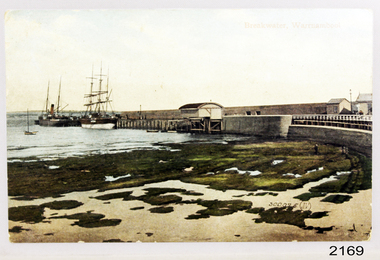 Flagstaff Hill Maritime Museum and Village
Postcard - Coastal Scene, Joseph Jordan Photographic Studio, Breakwater, Warrnambool, circa 1907
The Port of Warrnambool - In the early years the Port of Warrnambool was a busy port. Steamships and sailing ships were frequent visitors to the port. Steam navigation companies were plentiful, carrying passengers and freighting cargo such as coal, timber, food, livestock, furniture, hardware and haberdashery between Melbourne and the ports along the southwest coast of Victoria, including Warrnambool. The carts would take their loads into the township for distribution. The Breakwater was built (using 32 ton blocks of concrete) between 1874 and 1890 to provide ships with greater protection from the Southern Ocean. The Lifeboat and Rocket House - The coastline of South West Victoria has had over 600 shipwrecks and many lost lives; even in Warrnambool’s Lady Bay there were around 16 known shipwrecks between 1850 and 1905, with eight lives lost. In 1859 the first Government-built lifeboat arrived at Warrnambool Harbour and a shed was soon built to house it, followed in 1864 by a rocket house to safely store the Rocket Rescue equipment. In 1878 the buildings were moved to the Breakwater area, and in 1910 the new Lifeboat Warrnambool arrived with its ‘self-righting’ design. For almost one hundred years the lifeboat and rocket crews, mostly local volunteers, trained regularly to maintain and improve their skills, summoned when needed by alarms, gunshots, ringing bells and foghorns. Some became local heroes but all served an important role. By the end of the 1950s the lifeboat and rescue equipment had become obsolete. Joseph Jordan - Joseph Jordan was born in 1841 in Leicester England. When he was 16 he joined the 7th Queen's Own Hussars and was sent to India at the outbreak of the mutiny. He took part in the relief of Lucknow and remained in India for eleven years. It was during this time, he became interested in photography. He was posted to New Zealand and later came to Victoria, becoming a sergeant major of the Mounted Rifles. In the mid 1880s he came to the Western district where he was responsible for establishing units of the Mounted Rifles in various country towns such as Dunkeld, Mortlake, Panmure, Bushfield, Koroit etc. He resigned from the army in 1889 and set up a professional photography studio in Liebig Street, Warrnambool. He became very well known in the Western District for family photographs, official photographs of local councillors and groups as well as views of local scenery. In 1891 he photographed the wrecked barque "Fiji" at "Wrecks Beach" near Princetown. His business was taken over by his son Arthur around 1917. Joseph was a keen rifle shot and in 1924 he donated the "Jordan Shield" as a prize to the Victorian Rifle Association. He was made a "Life Honorary Member" of the Warrnambool Returned Soldiers League and in 1933 he was recognised as being the oldest living soldier in Victoria. Joseph died in 1935 aged 95. Valentine Publishing Company Pty. Ltd. Valentine and Sons was a printing and photography business based in Dundee, Scotland and Canada. In the early 1900's, at the height of the postcard craze, they published large numbers of postcards in the U.K., Canada, U.S., Australia and South Africa. Valentine postcards have a 6 digit serial number on the view side with the initials "J. V." in a circle adjacent to the number. The 300,000's related to views of Australia. From around 1900 (or earlier) the firm bought many images for their postcards from local and national photographers who sold publishing rights to Valentines.This postcard is significant for its association with the Port of Warrnambool and the Warrnambool Breakwater as it shows a point in time when shipping activities were an important part of Warrnambool's commerce and social development. It is also a record of the Warrnambool Lifeboat and Rocket house which was important in aiding ordinary citizens, harbour employees and the volunteer boat and rescue crew in saving the lives of sailors and passengers due to the high number of shipwrecks that occurred along the coastline. Joseph Jordan is a significant figure in Warrnambool history as he helped to establish early units of the Mounted Rifles (G Company) in local towns during the late 1880's and later, photographed local scenes, groups and citizens of early Warrnambool. It is also a culturally significant example of the type of postcards that were very popular in the early part of the 20th century.Photograph of breakwater from beachFront of card - Breakwater, Warrnambool / 300,025 J.V [in a circle] Back of card - POSTCARD / VALENTINE'S SERIES / - This space may be used for communication / The address only to be written here - Miss Alice Griffen / Howard St / Warrnambool - How are you enjoying your holiday we are grand. / from / Dodo, Dodo, Dodo with love - Leura? / Marjory Craig? / BL006 / R99A / REG NO 2169flagstaff hill, warrnambool, shipwrecked-coast, flagstaff-hill, flagstaff-hill-maritime-museum, maritime-museum, photograph, warrnambool breakwater, breakwater, shipwreck-coast, flagstaff-hill-maritime-village, warrnambool harbour, postcard, joseph jordan, valentine and sons, valentine publishing company, lady bay, life boat house, rocket house, steam ship, barque, jordan photography -
 Eltham District Historical Society Inc
Photograph, Upper Yarra Dam, Spring Tour, 22 Oct 1995, 22/10/1995
EXPLORING THE UPPER YARRA (Newsletter No. 105, November 1995, by Bettina Woodburn) We enjoyed the Spring Excursion, this year "Exploring the Upper Yarra" - in spite of the constant rain and the countryside under the cloud cover, especially in the valleys, being mainly shiny shades of green. The occasional fields of buttercups, clumps of arum lilies and splendid rhododendron and other flowering bushes became very special. The Cobb and Co coach was warm and a cosy retreat as we zig-zagged on the highways and byways to glimpse the Yarra River, upstream and down, its secret places, and particularly the many bridges. Russell excelled as 'Poet Laureate', reading from Dacre Smyth's book. This 1979 publication includes paintings of all the bridges along the river with poems and brief descriptions of each one. Some of the bridges are in out of the way places and are not very well known. We looked forward to hearing the poetry as much as seeing the ' constructions'…Big Pat (was he short or tall, lean or fat? He did win the two hundred pound reward for discovering gold and had the creek named after him), about the 'Eddies'?, and the disliked 'meccano' bridge in Warburton, etc. etc. The hot roast lunch in the old Reefton Hotel was also most welcome. It was easy to imagine it peopled by miners and early settlers. Starting by crossing the new (1974) concrete bridge at Warrandyte we headed through Wonga Park with views to the Christmas Hills and to the escarpment of the Yering Gorge, which causes flood waters to back up through the Yarra Glen plain, so avoiding disasters downstream. At the end of a long driveway we found the wooden, privately owned Henley Bridge (1935 after the 1934 floods). This facilitates access to different parts of Henley Farm and to Lilydale. Everard Park, named after Blanche Shallard's father, a State Member for 17 years, below the Highway Yarra crossing was in need of care. It is 10 miles from Yarra Glen by road but, as "Yarra Marra” canoeists well know, 32 winding miles down by water. After more delightful countryside scenes we joined the Warburton Highway at Woori Yallock. From the old Railway Station at Launching Place the Centennial Trail for walkers, cyclists and ' horse riders has replaced the rails. The line from Lilydale was opened in 1901, and the last diesel freight train ran to Warburton in 1965. It continued to rain as we had morning tea in Warburton in a shelter between footbridges. From here we continued upstream past the Bridge to O'Shannasy Lodge and Reservoir, Starvation Creek, and the Peninsular tunnel (miners dug it as at Pound Bend) which we visited (scrambling down those steps!) on our return after lunch. Our furthermost point was the Upper Yarra Dam Reserve (and vast catchment area). Finished in 1957 after ten years work and 100 years after Yan Yean, it supplies much of Melbourne's water. After crossing the 30m Launching Place Bridge to the Eltham side of the Yarra and Healesville, we saw in the distance the Yarra Glen Timber Trestle Bridge over the river flats "the longest for years in the land it was said!" Harry's dream of "better weather over the Divide" unfortunately didn't come true, but I'm sure we 36 members will retain happy memories of a day that was wet and green and filled with Bridges. Bettina Woodburn - October 1995 Record of the Society's history of activities - Spring 1995 excursionColour photographshire of eltham historical society, activities, upper yarra dam, henley bridge -
 Eltham District Historical Society Inc
Photograph, Peter Pidgeon, Victorian Labor Government Press Release announcing planned upgrades to Hurstbridge line rail services and protection of historic Railway Trestle Bridge, Panther Place, Eltham, 1 August 2018, 1 Aug 2018
Announcement by Premier Daniel Andrews, Minister for Public Transport, Jacinta Allan and Member for Eltham, Vicki Ward mad alongside the Eltham Railway Trestle Bridge. MEDIA RELEASE "More Trains And Fewer Delays On The Hurstbridge Line" https://www.premier.vic.gov.au/wp-content/uploads/2018/08/180801-More-Trains-And-Fewer-Delays-On-The-Hurstbridge-Line-1.pdf Commuters on the Hurstbridge line will have more trains, more seats and fewer delays with a re-elected Andrews Labor Government to continue its massive upgrade of the Hurstbridge line. The Andrews Labor Government said it would deliver locals in Melbourne’s north-east more peak hour train services and less time stuck at boom gates, and we have. The first stage of the Hurstbridge Line Upgrade has been delivered – six months early and on budget. This includes the new Rosanna Station, duplicated track between Heidelberg and Rosanna and the removal of the dangerous level crossings at Alphington and Rosanna. There’s more to do and only Labor will deliver the next stage of the Hurstbridge Line Upgrade to give local commuters more train services and a more comfortable commute. The $530 million project will include a brand new train station at Greensborough and the duplication of three kilometres of track between Greensborough and Montmorency, and 1.5 kilometres of track between Diamond Creek and Wattle Glen to allow more train services during the morning peak. This will allow trains to run every six and a half minutes at Greensborough, every 10 minutes at Eltham and Montmorency, and every 20 minutes at Hurstbridge, Diamond Creek and Wattle Glen – as well as two extra Hurstbridge express services. Locals on the Labor Government’s new Mernda line will also get five extra train services during the morning peak, with a major upgrade of the Clifton Hill junction where the Mernda and Hurstbridge lines connect. Labor will also protect the Eltham Trestle Bridge – the last remaining timber bridge on Melbourne’s electric train network – which has local heritage protection and is an important part of the area’s character. The Liberals will leave this bridge to rot and demolish the nearby childcare centre and football club with their under-cooked and under-costed promise to upgrade the Hurstbridge line. Only Labor will protect this important piece of Melbourne’s history with planning work to be carried out for a long-term solution as part of the project. Stage two of the Hurstbridge Line Upgrade will create more than 950 jobs, with construction to start in 2020 and finish by 2022. Quotes attributable to Premier Daniel Andrews “We said we’d upgrade the Hurstbridge line and remove dangerous and congested level crossings at Rosanna and Alphington and we did – but there’s more to do.” “Only Labor will deliver the next stage of the Hurstbridge Line Upgrade with a new Greensborough Station and more trains, more often.” Quote attributable to Minister for Public Transport Jacinta Allan “The former Liberal Government promised new train lines but didn’t deliver a single kilometre of track – now they’re promising a half-baked upgrade of the Hurstbridge line with rubbery figures that don’t add up.” Quote attributable to Member for Eltham Vicki Ward “As a fifteen year old hopping on Red Rattlers at Eltham I wanted to do something to make the Hurstbridge line better. It’s taken me a few decades but finally our line will offer the frequency of services that are expected and needed in a 21st century city.”Born digital image (qty 27)jacinta allan, minister for public transport, panther place, premier daniel andrews, press announcement, railway line construction, trestle bridge, vicki ward mp for eltham, victorian parliament -
 Eltham District Historical Society Inc
Photograph, Upper Yarra Dam, Spring Tour, 22 Oct 1995, 22/10/1995
EXPLORING THE UPPER YARRA (Newsletter No. 105, November 1995, by Bettina Woodburn) We enjoyed the Spring Excursion, this year "Exploring the Upper Yarra" - in spite of the constant rain and the countryside under the cloud cover, especially in the valleys, being mainly shiny shades of green. The occasional fields of buttercups, clumps of arum lilies and splendid rhododendron and other flowering bushes became very special. The Cobb and Co coach was warm and a cosy retreat as we zig-zagged on the highways and byways to glimpse the Yarra River, upstream and down, its secret places, and particularly the many bridges. Russell excelled as 'Poet Laureate', reading from Dacre Smyth's book. This 1979 publication includes paintings of all the bridges along the river with poems and brief descriptions of each one. Some of the bridges are in out of the way places and are not very well known. We looked forward to hearing the poetry as much as seeing the ' constructions'…Big Pat (was he short or tall, lean or fat? He did win the two hundred pound reward for discovering gold and had the creek named after him), about the 'Eddies'?, and the disliked 'meccano' bridge in Warburton, etc. etc. The hot roast lunch in the old Reefton Hotel was also most welcome. It was easy to imagine it peopled by miners and early settlers. Starting by crossing the new (1974) concrete bridge at Warrandyte we headed through Wonga Park with views to the Christmas Hills and to the escarpment of the Yering Gorge, which causes flood waters to back up through the Yarra Glen plain, so avoiding disasters downstream. At the end of a long driveway we found the wooden, privately owned Henley Bridge (1935 after the 1934 floods). This facilitates access to different parts of Henley Farm and to Lilydale. Everard Park, named after Blanche Shallard's father, a State Member for 17 years, below the Highway Yarra crossing was in need of care. It is 10 miles from Yarra Glen by road but, as "Yarra Marra” canoeists well know, 32 winding miles down by water. After more delightful countryside scenes we joined the Warburton Highway at Woori Yallock. From the old Railway Station at Launching Place the Centennial Trail for walkers, cyclists and ' horse riders has replaced the rails. The line from Lilydale was opened in 1901, and the last diesel freight train ran to Warburton in 1965. It continued to rain as we had morning tea in Warburton in a shelter between footbridges. From here we continued upstream past the Bridge to O'Shannasy Lodge and Reservoir, Starvation Creek, and the Peninsular tunnel (miners dug it as at Pound Bend) which we visited (scrambling down those steps!) on our return after lunch. Our furthermost point was the Upper Yarra Dam Reserve (and vast catchment area). Finished in 1957 after ten years work and 100 years after Yan Yean, it supplies much of Melbourne's water. After crossing the 30m Launching Place Bridge to the Eltham side of the Yarra and Healesville, we saw in the distance the Yarra Glen Timber Trestle Bridge over the river flats "the longest for years in the land it was said!" Harry's dream of "better weather over the Divide" unfortunately didn't come true, but I'm sure we 36 members will retain happy memories of a day that was wet and green and filled with Bridges. Bettina Woodburn - October 1995 Record of the Society's history of activities - Spring 1995 excursionRoll of 35mm colour negative film, 3 stripsKodak Gold 200-4shire of eltham historical society, activities, upper yarra dam, henley bridge -
 Eltham District Historical Society Inc
Photograph, Upper Yarra Dam, Spring Tour, 22 Oct 1995, 22/10/1995
EXPLORING THE UPPER YARRA (Newsletter No. 105, November 1995, by Bettina Woodburn) We enjoyed the Spring Excursion, this year "Exploring the Upper Yarra" - in spite of the constant rain and the countryside under the cloud cover, especially in the valleys, being mainly shiny shades of green. The occasional fields of buttercups, clumps of arum lilies and splendid rhododendron and other flowering bushes became very special. The Cobb and Co coach was warm and a cosy retreat as we zig-zagged on the highways and byways to glimpse the Yarra River, upstream and down, its secret places, and particularly the many bridges. Russell excelled as 'Poet Laureate', reading from Dacre Smyth's book. This 1979 publication includes paintings of all the bridges along the river with poems and brief descriptions of each one. Some of the bridges are in out of the way places and are not very well known. We looked forward to hearing the poetry as much as seeing the ' constructions'…Big Pat (was he short or tall, lean or fat? He did win the two hundred pound reward for discovering gold and had the creek named after him), about the 'Eddies'?, and the disliked 'meccano' bridge in Warburton, etc. etc. The hot roast lunch in the old Reefton Hotel was also most welcome. It was easy to imagine it peopled by miners and early settlers. Starting by crossing the new (1974) concrete bridge at Warrandyte we headed through Wonga Park with views to the Christmas Hills and to the escarpment of the Yering Gorge, which causes flood waters to back up through the Yarra Glen plain, so avoiding disasters downstream. At the end of a long driveway we found the wooden, privately owned Henley Bridge (1935 after the 1934 floods). This facilitates access to different parts of Henley Farm and to Lilydale. Everard Park, named after Blanche Shallard's father, a State Member for 17 years, below the Highway Yarra crossing was in need of care. It is 10 miles from Yarra Glen by road but, as "Yarra Marra” canoeists well know, 32 winding miles down by water. After more delightful countryside scenes we joined the Warburton Highway at Woori Yallock. From the old Railway Station at Launching Place the Centennial Trail for walkers, cyclists and ' horse riders has replaced the rails. The line from Lilydale was opened in 1901, and the last diesel freight train ran to Warburton in 1965. It continued to rain as we had morning tea in Warburton in a shelter between footbridges. From here we continued upstream past the Bridge to O'Shannasy Lodge and Reservoir, Starvation Creek, and the Peninsular tunnel (miners dug it as at Pound Bend) which we visited (scrambling down those steps!) on our return after lunch. Our furthermost point was the Upper Yarra Dam Reserve (and vast catchment area). Finished in 1957 after ten years work and 100 years after Yan Yean, it supplies much of Melbourne's water. After crossing the 30m Launching Place Bridge to the Eltham side of the Yarra and Healesville, we saw in the distance the Yarra Glen Timber Trestle Bridge over the river flats "the longest for years in the land it was said!" Harry's dream of "better weather over the Divide" unfortunately didn't come true, but I'm sure we 36 members will retain happy memories of a day that was wet and green and filled with Bridges. Bettina Woodburn - October 1995 Record of the Society's history of activities - Spring 1995 excursionRoll of 35mm colour negative film, 3 stripsKodak Gold 200-4shire of eltham historical society, activities, upper yarra dam, henley bridge