Showing 42156 items matching "were"
-
 Kew Historical Society Inc
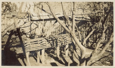
Photograph - Victorian Canoe Club, Mould for racer, 1920-30
Canoeing on the River Yarra at Melbourne was an important and widespread recreational pursuit for Melbournians, especially in the first half of the twentieth century. The Victorian Canoe Club was formed in 1912 at a meeting in Melbourne and its first committee elected in the same year. Records indicate that the Club continued into at least the 1950s .The album has historic and social significance as a record of recreational activities (as well as canoe making) in the early years of the twentieth century. It has local significance as the site of the headquarters of the Club was in Studley park. A number of photographs in the album provide vistas of Kew on the Yarra that are otherwise unavailable.One of 24 labelled photos in part album, originating from the Victorian Canoe Club, which had its headquarters in Studley Park, Kew. The album includes a photographic record of canoe construction and also locations in Studley Park and Kew where the canoes were used. The subject of this photograph is identified as 'Mould for racer' which was set up in a backyard to form the frame for manufacturing a racing canoe."Mould for racer"victorian canoe club, canoe making, canoe construction, canoe moulds -
 Kew Historical Society Inc
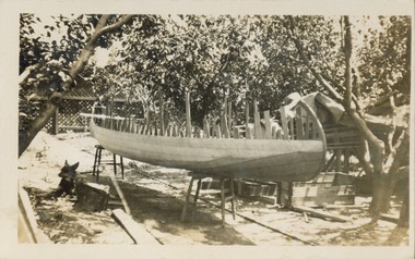
Photograph - Victorian Canoe Club, Off mould, 1920-30
Canoeing on the River Yarra at Melbourne was an important and widespread recreational pursuit for Melbournians, especially in the first half of the twentieth century. The Victorian Canoe Club was formed in 1912 at a meeting in Melbourne and its first committee elected in the same year. Records indicate that the Club continued into at least the 1950s .The album has historic and social significance as a record of recreational activities (as well as canoe making) in the early years of the twentieth century. It has local significance as the site of the headquarters of the Club was in Studley park. A number of photographs in the album provide vistas of Kew on the Yarra that are otherwise unavailable.One of 24 labelled photos in part album, originating from the Victorian Canoe Club, which had its headquarters in Studley Park, Kew. The album includes a photographic record of canoe construction and also locations in Studley Park and Kew where the canoes were used. The subject of this photograph is identified as 'Off mould' where, following the completion of the hull, the boat is 'righted' to allow for the finishing of the canoe.."Off mould"victorian canoe club, canoe making, river yarra, burke road, mornington, studley park, kew, steaming gear, canoe construction -
 Kew Historical Society Inc
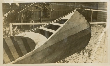
Photograph - Victorian Canoe Club, Built-up ends & deck frames, 1920-30
Canoeing on the River Yarra at Melbourne was an important and widespread recreational pursuit for Melbournians, especially in the first half of the twentieth century. The Victorian Canoe Club was formed in 1912 at a meeting in Melbourne and its first committee elected in the same year. Records indicate that the Club continued into at least the 1950s .The album has historic and social significance as a record of recreational activities (as well as canoe making) in the early years of the twentieth century. It has local significance as the site of the headquarters of the Club was in Studley park. A number of photographs in the album provide vistas of Kew on the Yarra that are otherwise unavailable.One of 24 labelled photos in part album, originating from the Victorian Canoe Club, which had its headquarters in Studley Park, Kew. The album includes a photographic record of canoe construction and also locations in Studley Park and Kew where the canoes were used. The subject of this photograph is identified as 'Built-up ends & deck frames' where the canoe its completed and ready for testing."Built-up ends & deck frames"victorian canoe club, canoe making, river yarra, burke road, mornington, studley park, kew, steaming gear, canoe construction -
 Kew Historical Society Inc
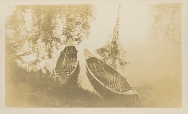
Photograph - Victorian Canoe Club, Nagha & Dunapna completed completed, 1920-30
Canoeing on the River Yarra at Melbourne was an important and widespread recreational pursuit for Melbournians, especially in the first half of the twentieth century. The Victorian Canoe Club was formed in 1912 at a meeting in Melbourne and its first committee elected in the same year. Records indicate that the Club continued into at least the 1950s .The album has historic and social significance as a record of recreational activities (as well as canoe making) in the early years of the twentieth century. It has local significance as the site of the headquarters of the Club was in Studley park. A number of photographs in the album provide vistas of Kew on the Yarra that are otherwise unavailable.One of 24 labelled photos in part album, originating from the Victorian Canoe Club, which had its headquarters in Studley Park, Kew. The album includes a photographic record of canoe construction and also locations in Studley Park and Kew where the canoes were used. The subject of this photograph is identified as 'Nagha & Dunapna completed' with an overhead view of two named canoes on the banks of the Yarra River."Nagha & Dunapna completed"victorian canoe club, canoe making, river yarra, burke road, mornington, studley park, kew, steaming gear, canoe construction -
 Kew Historical Society Inc
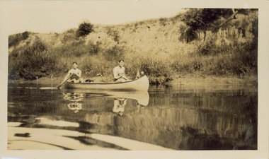
Photograph - Victorian Canoe Club, Yarra near Burke Road, 1920-30
Canoeing on the River Yarra at Melbourne was an important and widespread recreational pursuit for Melbournians, especially in the first half of the twentieth century. The Victorian Canoe Club was formed in 1912 at a meeting in Melbourne and its first committee elected in the same year. Records indicate that the Club continued into at least the 1950s .The album has historic and social significance as a record of recreational activities (as well as canoe making) in the early years of the twentieth century. It has local significance as the site of the headquarters of the Club was in Studley park. A number of photographs in the album provide vistas of Kew on the Yarra that are otherwise unavailable.One of 24 labelled photos in part album, originating from the Victorian Canoe Club, which had its headquarters in Studley Park, Kew. The album includes a photographic record of canoe construction and also locations in Studley Park and Kew where the canoes were used. The subject of this photograph is identified as 'Near Burke Road' with two young men in a canoe on a still section of the Yarra. "Near Bourke Rd"victorian canoe club, river yarra, studley park, canoe clubs, canoeing, recreation -- canoeing, burke road -- kew (vic.) -
 Kew Historical Society Inc
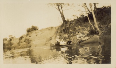
Photograph - Victorian Canoe Club, Yarra near Burke Road, 1920-30
Canoeing on the River Yarra at Melbourne was an important and widespread recreational pursuit for Melbournians, especially in the first half of the twentieth century. The Victorian Canoe Club was formed in 1912 at a meeting in Melbourne and its first committee elected in the same year. Records indicate that the Club continued into at least the 1950s .The album has historic and social significance as a record of recreational activities (as well as canoe making) in the early years of the twentieth century. It has local significance as the site of the headquarters of the Club was in Studley park. A number of photographs in the album provide vistas of Kew on the Yarra that are otherwise unavailable.One of 24 labelled photos in part album, originating from the Victorian Canoe Club, which had its headquarters in Studley Park, Kew. The album includes a photographic record of canoe construction and also locations in Studley Park and Kew where the canoes were used. The subject of this photograph is identified as 'Near Burke Road' with three men and a dog in a canoe on a still section of the Yarra. "Near Bourke Rd"victorian canoe club, river yarra, studley park, canoe clubs, canoeing, recreation -- canoeing, burke road -- kew (vic.) -
 Kew Historical Society Inc
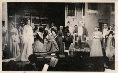
Photograph, The "Q" Theatre Guild, The Bohemian Girl, 1959
The "Q" Theatre Guild was formed out of the Kew Light Opera Company in 1957. It marked the transition of the company that had initially been directed by Lance Nicholls to one directed by Beatrice Oakley. It continued to perform in the Kew Recreation Hall, but, with its demolition in 1960, and the opening of the new Kew City Hall in Cotham Road, moved its productions to that venue. Productions of the "Q" Theatre Guild included The Geisha (1957), Maritana (1958), They All Do It (1959), Blossom Time (1959), Love's A Luxury (1959), There And Back & The Bohemian Girl (1960), Die Fledermaus (1960), Gay Rosalinda (1961), The Land Of Smiles (1961), Kisses For A Kid & Hansel And Gretel (1961), Die Fledermaus (1962), Monsieur Beaucaire (1964), Macbeath or The Beggar's Opera, and So To Bed.The scrapbook of annotated photographs, programmes, and newspaper reviews of which this item is a part was assembled by Marion Tilley, wardrobe mistress for, and performer in, productions by the Kew Light Opera Company and the "Q" Theatre Guild. It is significant as a remarkably complete document of theatre performances in Kew, Victoria during the 1950s and 1960s. The scrapbook, and the items individually catalogued within it, have artistic and aesthetic significance within the history of performing arts in Victoria in the middle of the 20th Century. They have social significance in that they reveal socio-cultural values and preoccupations during the period. The records also act as a history of arts activities in the Kew Recreation Hall and later in the Kew City Hall as entertainment and community arts and music precincts.Black and white photograph of members of the cast of the "Q" Theatre Guild in their 1959 production of Michael Balfe's The Bohemian Girl. Beatrice Oakley was the producer and John Trotter the musical director. The costumes were designed and made by Marion Tilley while the scenery was designed by Claude Ward and Lachlan Stebbins. An annotation, in the corresponding programme, records that Joan Carden (later a star of the Australian Opera) performed in the Ladies of the Chorus.Marion Tilley, the creator of the scrapbook, wrote the following names underneath the photograph: "Fred C., Esme M., Val Breen, Jeanette R., Alan Wilson, B. Meagher, Irene T., Gwen Bolden".performing arts -- kew (vic.), scrapbooks, marion tilley collection, 'q' theatre guild, kew recreation hall, theatre programmes, musical comedy -- melbourne -- victoria -
 Kew Historical Society Inc
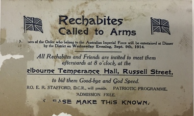
Memorabilia - Invitation, Rechabites: Called To Arms, 1914, 1914
An invitation to a meeting at the Temperance Hall, Russell Street, Melbourne to all members and friends in order to meet members of the Order who had joined the Australian Imperial Forces. The meeting was to be held after a dinner for the enlisted men on Wednesday evening, September 9th in 1914. The invitation and item 2017.0078 were discovered during renovations to the house situated at 31 (now 68) Charles Street, Kew. . rechabites - kew (vic.), kew recreation hall, first world war, ww1, 68 charles street - kew (vic.) -
 Kew Historical Society Inc
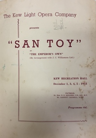
Programme, Kew Light Opera Company, San Toy OR The Emperor's Own, 1953
The Kew Light Opera Company was formed in 1952, and mounted a number of musical and variety productions each year until it was subsumed in the "Q" Theatre Guild in 1957. Most of the Company's performances took place in the Kew Recreation Hall in Wellington Street, Kew. A list of its productions by year includes: 1952 Florodora 1953 The Cingalee 1953 San Toy OR The Emperor’s Own 1953 Celebratory variety performance 195? While the Sun Shines 1954 A Country Girl 1954 Our Miss Gibbs 1955 The Toreador 1955 The Arcadians 1956 The Maid of the Mountains 1956 Whiteoaks 1956 Good night Vienna! 1957 A Country GirlThe Marion Tilley scrapbook is a significant record of performing arts in Melbourne during the 1950s and 1960s. The scrapbook includes programmes, photographs, newspaper reports and personal annotations which are a rich source of detail about repertoire, performers, and artistic sensibility in the period.Souvenir programme isued by the Kew Light Opera Company for a performance of 'San Toy: or The Emperor's Own'. Performances were held in the Kew Recreation Hall on 1, 3, 4, 5 December 1953. The cast list is signed by members of the company. The programme forms part of a scrapbook that includes programmes, photographs and theatre reviews for the Kew Light Opera Company and later "Q" Theatre Guild.theatre (kew), performing arts, kew light opera company, san toy -
 Kew Historical Society Inc
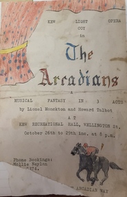
Programme, Kew Light Opera Company, The Arcadians, 1955
The Kew Light Opera Company was formed in 1952, and mounted a number of musical and variety productions each year until it was subsumed in the "Q" Theatre Guild in 1957. Most of the Company's performances took place in the Kew Recreation Hall in Wellington Street, Kew. A list of its productions by year includes: 1952 Florodora 1953 The Cingalee 1953 San Toy OR The Emperor’s Own 1953 Celebratory variety performance 195? While the Sun Shines 1954 A Country Girl 1954 Our Miss Gibbs 1955 The Toreador 1955 The Arcadians 1956 The Maid of the Mountains 1956 Whiteoaks 1956 Good night Vienna! 1957 A Country GirlThe Marion Tilley scrapbook is a significant record of performing arts in Melbourne during the 1950s and 1960s. The scrapbook includes programmes, photographs, newspaper reports and personal annotations which are a rich source of detail about repertoire, performers, and artistic sensibility in the period.Souvenir programme isued by the Kew Light Opera Company for a performance of 'The Arcadians: a Musical Fantasy in 3 Acts' by Lionel Monckton and Howard Talbot. Performances were held in the Kew Recreation Hall on 26, 27, 28, 29 October 1955. The programme forms part of a scrapbook that includes programmes, photographs and theatre reviews for the Kew Light Opera Company and later "Q" Theatre Guild.theatre (kew), performing arts, kew light opera company, the arcadians (musical), kew recreation hall -
 8th/13th Victorian Mounted Rifles Regimental Collection
Photograph - Scene at Dimboola
VMR Heritage Troop was a very public face of the regiment during the 1980s and early 1990s. It conducted one royal escort, several vice-regal escorts and numerous VIP escorts in the border, north-east and wider Victorian locations. The royal duty was at the opening of Hopkins Barracks, Puckapunyal by HRH Prince Charles accompanied by HRH Princess Diana, 31 October 1985. Major General Kevin Cooke GOC 3rd Division authorised the establishment of the troop in February 1980. Captain (later Major) Robert Morrison was the troop leader and the driving force behind the concept seeing potential where others did not. The troop was made up mainly by serving members of 8/13 but did include some civilian members. Training and advice came from former light horsemen: Des Martin (8LH), Norm Whitehead (21LH), Bob Fyffe (20LH) and Fred Trickey (Riding Master RMC). This was an example of the troop engaging in a community activity. Colour photograph of street scene in the Victorian town of Dimboola, June 1986. It was a set for shooting an episode of a TV series "Flying Doctors" and included a cameo appearance of a section of four light horsemen from the 8/13 Victorian Mounted Rifles Heritage Troop. Horsemen were Corporals S Walch, A Florent, N Morris and Trooper C Ellison. Photo is glued to a fluted plastic card.light horse, dimboola, television, flying doctors -
 Mont De Lancey
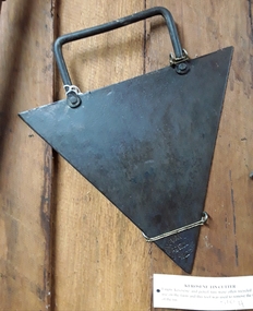
Tool - Kerosene Tin Cutter, Chapman and Co, Unknown
Used in the late 19th or early 20th century.A large triangular shaped metal blade tin cutter for manually opening kerosene and petrol tin lids which were often recycled for use on farms in the 19th and early 20th century. It has a rectangular shaped tubular steel handle attached to the top side by two rivets. On one of the triangular points of the blade is the manufacturer's brand ' Chapman and Co, Enfield S.A'. It was Australian made.'Chapman and Co, Enfield S..A'. tin openers, tools, tin cutter, farming equipment -
 Wodonga & District Historical Society Inc
Photograph - Fred Rochow Railways Collection - Wodonga to Sydney express, C. 1925
The Fred Rochow Railways Collection incorporates photos related to the operation of the Wodonga Railway Station including different types of trains and railways staff C. 1930 – 1990. It was donated to the Wodonga Historical Society by Fred Rochow, a railwayman who spent many years based in Wodonga. He joined the Victorian Railways on 17th June l947 and retired in 1988. For some time, he was a member of the Australian Federated Union of Locomotive Enginemen and served a term as a member of the Trades Hall Council. He had an extensive knowledge of the struggles that took place to achieve better conditions for railway workers. Fred worked for many years as a fireman and then worked his way up the ranks to driver, experiencing many changes from the days of steam locomotives through to diesel trains, locomotives and even the modern XPT train. He worked throughout Victoria at different stages of his career, with his final working years focused on the northeast of Victoria and the Albury to Melbourne line. After his retirement, Fred continued to share his love of steam miniature trains with the community.This collection has local and statewide significance as it captures images of trains, locomotives and personnel who operated the railway services in Wodonga and throughout Northeast Victoria. The railways played a critical role in opening up Victoria and connecting Australia for trade, business, social communication and transport.The up Sydney Express departing Wodonga on its journey to Melbourne. This photo was taken by famous Wodonga driver George Lynch. The elliptical roof CE van helps date this photo as the first one didn't appear until 1924. Electric headlights started appearing in 1926 and were first utilised on the Sydney and Adelaide expresses which means the photo was taken sometime between 1924 and 1926.railways wodonga, fred rochow, wodonga railwaymen, steam locomotives -
 Wodonga & District Historical Society Inc
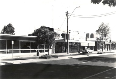
Photograph - Codling Collection 01 - Wodonga, High Street West - S.E.C.; Health Foods; Marks Bros.; Westpac, 1980s
Miss Olive Codling was a Foundation Member and a Life Member of the Wodonga Historical Society. Many of her prize-winning photos are held in the Society Collection. She also held a range of roles and committee positions in a wide range of Wodonga community organisations. These included the Horticultural Society, the Wodonga Arts Council, the Wodonga Camera Club and the Wodonga Lapidary Club. This photo collection is significant as it documents how the businesses and buildings in Wodonga have evolved and contributed to community throughout the 20th century.Wodonga, High Street West Businesses including S.E.C.; Health Foods; Marks Bros. and Westpac. These shops were opposite the current post office. The site of the Health Foods shop in 2021 is occupied by Take Time Cafe. Marks Bros. Butchers at 145 High Street is the location of Free Choice Tobacconist next to Skin Wodonga. Westpac Wodonga is still located at 141 High Street.wodonga businesses, high st wodonga, marks brothers butchers -
 Bendigo Historical Society Inc.
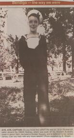
Newspaper - JENNY FOLEY COLLECTION: AYE, AYE CAPTAIN
BHS CollectionBendigo Advertiser ''The way we were'' from Monday, July 22, 2002. Aye, aye captain: do you know this sailor? He was an 18 or 19 year old sailor aboard the HMAS Sydney, which was sunk off the Western Australia coast in about 1941. He lived in Golden Square, and is believed to be named James. Photo supplied by E. Walsh. The clip is in a folder.newspaper, bendigo advertiser, the way we were -
 Linton and District Historical Society Inc
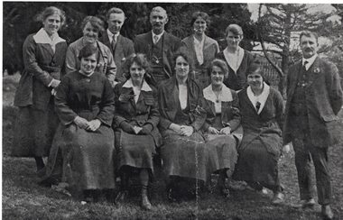
Photograph, Linton Presbyterian Church Choir, circa 1920
Black and white photograph which was copied from the Presbyterian Church "Diamond Jubilee" booklet (see Registration no. 1645). Photograph shows members of the Linton Presbyterian Church choir with their conductor, Mr Maddock. The photograph includes the caption from the original publication. This identifies members of the choir by their surnames only. Additional names, including first names, were provided at the time the photograph was copied for LDHS.presbyterian church choir, choirs, gertrude cox, jean cox, cassie mcbeath, alex mcbeath, george bennett, mary hitchins (née rankin), miss johnston, miss gascoigne, miss maddock, miss wishart, mr maddock [choir conductor] -
 Linton and District Historical Society Inc
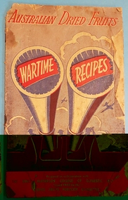
Recipe book, Australian Dried Fruits Wartime Recipes
16-page recipe booklet, no illustrations. Produced during World War II by the Dried Fruits Publicity Committee (acting on behalf of various Australian dried fruits industry bodies) "to assist the housewife in the preparation of attractive cakes, puddings etc", at a time when supplies of foodstuffs were restricted through rationing. Prepared in collaboration with the Emily McPherson College of Domestic Economy. Pages 16recipe books, cookery books, recipes, dried fruits, world war 1939-1945, rationing -
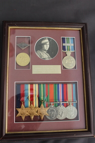 Dandenong/Cranbourne RSL Sub Branch
Photograph - Framed photograph and medals
Photograph of PTE. Alfred Claude Westray. VX52881. Army Ordnance Corps . Mounted in picture frame with - 39-45 Star, Africa Star, Pacific Star, Defence Medal, War Medal 39-45, Australian Service Medal 45-75, Service Medal with Bar. 2005 60th Anniversary of the End of WW II Service to Australia Medal. Medals were mounted in 2005 and 2007. -
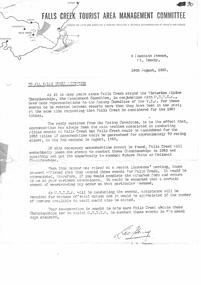 Falls Creek Historical Society
Letter - Accommodation During Victorian Alpine Championships
Bob (Herman) Hymans (a former member of the Royal Netherlands Navy) was born in Bloemendaal, Holland on 30th September 1922. During World War II he fought against the Japanese in the Dutch East Indies (now Indonesia) and was imprisoned in Changi and on the Burma Railway. After gaining qualifications as a Ski Instructor, Bob arrived in Falls Creek in July 1950. Working as an Instructor and Supervisor at Bogong Lodge, Bob decided his future was in accommodation. He was successful in negotiating an indenture for land from the State Electricity Commission (SEC). It took Bob two years to build his Grand Coeur Chalet but, tragically, it was burned down in August 1961. Bob also built the first Chairlift in Australia. This was a single chairlift and the structure was built from wooden electricity poles. He was constantly full of new ideas and proposals for the village. Bob Hymans died on 7th July 2007. This Collection of documents and letters tells the story of Bob's endeavours to develop Falls Creek into the ski village it is today.This letter is significant because it documents developments made or endorsed by the Falls Creek Tourist Area Management Committee.A letter from the Falls Creek Tourist Area Management Committee to all Licensees requesting support in an attempt to gain the right to stage the Victorian Alpine Championships in August 1963. In order to be successful an assurance of adequate availability of accommodation was needed. Licensees were asked to indicate how much accommodation they would have available as well as the number of persons they would have available to assist in the running of the event.falls creek tourist area management committee, falls creek administration, falls creek accommodation, ski championships -
 Linton and District Historical Society Inc
Photograph, Linton State School Pupils, 1969
Back row from left: David Sturni, Brendan Greenbank, Terry Grigg, BARBARA NEWELL, Sally Birnie (nee Caldow), JANINE STONEY, CATHERINE DEAN, LEN/ GARY TURNER NEXT LINE: GLENDA CLUFF, BARBARA OLDAM, ELIZBABETH DARK, JUNE JACKSON, MAYBE A MATTHEWS, KEVIN UREN, GEOFF CHING. NEXT LINE: RICKY LAWSON, COLIN STONEY, GAVIN STURNI, ROBERT JACKSON, GARY MATTHEWS, GERARD WILKIE, PETER GRIGG. FRONT ROW: JANET UREN, ELIZABETH CHING, SHERYL MCDONALD, DEBBIE CHENERY, JEANETTE JACKSON, SANDRA CHING, ANNE MCDONALD, FELICITY DEAN ON THE END.Enlarged copy of black and white photograph, mounted on white card. Pupils and teacher are shown outside the new school building, opened in 1969 to replace the original building which had been declared unsafe. Teacher was Mr V. H. Reynolds, who was Head Teacher 1969-1971, and taught grades 4-6. Pupils were identified in 2022 by Sally Birnie, née Caldow.linton state school no. 880 -
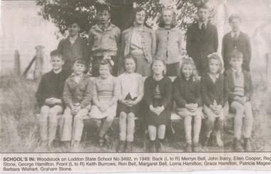 Bendigo Historical Society Inc.
Newspaper - JENNY FOLEY COLLECTION: SCHOOL'S IN
BHS CollectionBendigo Advertiser ''The way we were'' from 2003. School's in: Woodstock on Loddon state school no. 3492, in 1949. Back left to right: Merryn Bell, John Barry, Ellen Cooper, Reg Stone, George Hamilton. Front: Keith Burrows, Ron Bell, Margaret Bell, Lorna Hamilton, Grace Hamilton, Patricia Magee, Barbara Wishart, Graham Stone. The clip is in a folder.newspaper, bendigo advertiser, the way we were -
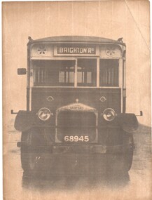 Melbourne Tram Museum
Photograph - Black & White Photograph/s, Melbourne & Metropolitan Tramways Board (MMTB), 1925
Black and white photograph, front on of Garford Bus, with registration No. 68945 and the destination Brighton Road. Rod Atkin advised by email of 25/9/17 that was MMTB Bus No. 45 One of two Gardford HL model buses (45 & 46) which entered service in 1925 and were both out of use by 1935 when the chassis was disposed of and the bodies modified for reuse on new chassis.trams, tramways, mmtb, buses, brighton rd, garford -
 Melbourne Tram Museum
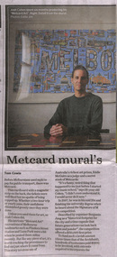
Newspaper, The Age, “Metcard mural's long and winding journey”, 17/04/2020 12:00:00 AM
Newspaper clippings titled: “Metcard mural's long and winding journey” by Tom Cowie Newspaper clipping from the Age 17/04/2020 Josh Cohen has created "Metcard Art", recreations of Melbourne's landmarks using Metcards. Metcards were sourced from personal collection, friends and eBay and artwork took 6 months to produce. Created for the Signature of M art competition in 2007.trams, tramways, metcard, melbourne, art -
 Melbourne Tram Museum
Negative, Ellis Collection, 1940
Negative (120) of a cable tram grip car and saloon car northbound in Nicholson St between Victoria Parade and Gertrude St. Has the Salisbury Place (34 Nicholson St) block in the view. Photo 1940 based on the date that other photos were taken in the area - See Reg Item 3593. Hi Res image filed in the dbtext/hawthtramcoll/Large Images/htd3593large.jpgtrams, tramways, cable trams, nicholson st, cable trams -
 Melbourne Tram Museum
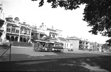
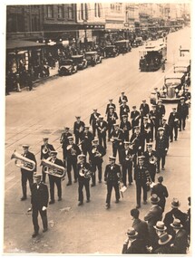
Photograph - Black & White Photograph/s, mid 1930s
Black and white photographs of a band marching across the intersection of Bourke and Swanston about mid-1930. Has a cable set descending the hill. In the background is a number of parked motor vehicles. The band is followed by a number of cars and is being watched by some people on the corner. The buildings on the top left were later demolished to make way for the Foys building. The arches of the Esquire cinema in the background are visibletrams, tramways, bourke st, bands, swanston st, cable trams -
 Bendigo Historical Society Inc.
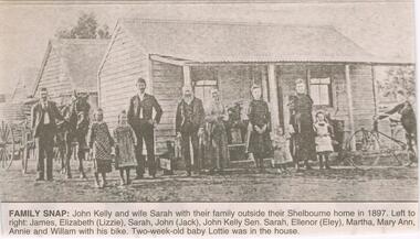
Newspaper - JENNY FOLEY COLLECTION: FAMILY SNAP
John Kelly (1859-1941) was born at Lockwood, the son of Patrick and Ann Kelly. In 1873 he married Sarah Ann Nievandt and they had 11 children. John Andrew (Jack) 1874-1952; James 1877-1878; James (1878- ); Mary Ann (1880- ); Eleanor Harriet (1883-1982); William Patrick (1885-1965); Elizabeth Margaret (1887- ); Sarah Louise (1889- ); Annie (1892-1902); Lottie (1897- ) . Eleanor married George James Lakey in 1904. No birth record found for Martha. This photo can be dated to 1897/98Bendigo Advertiser ''The way we were'' from 2003. Family snap: John Kelly and wife Sarah with their family outside their Shelbourne home in 1897. Left to right: James, Elizabeth (Lizzie), Sarah, John (Jack), John Kelly Sen., Sarah, Ellenor (Eley), Martha, Mary Ann, Annie and William with his bike. Two-week old baby Lottie was in the house. The clip is in a folder.newspaper, bendigo advertiser, the way we were -
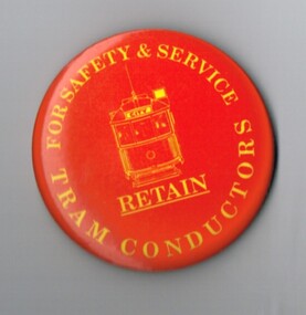 Melbourne Tram Museum
Ephemera - Badge/s, Patrick Bros Melbourne, "Retain Tram Conductors", Jan. 1990
Badge - featuring the front of a W class tram with the destination of city, yellow on a red background, with the words "For Safety and Service, Retain Tram Conductors" Has a pin on the rear to enable to be fixed to an item of clothing. Has manufacturer's name stamped in rear of badge - Patrick Bros Melbourne. Advised by Neil Elphick 23/6/2018 that they were made at the time of the big strike - January 1990.trams, tramways, the met, conductors, melbourne, badges -
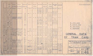 Melbourne Tram Museum
Document - Tramcar Data Sheet, Melbourne & Metropolitan Tramways Board (MMTB), "General Data of Tram cars", c1920's
Dyeline print of Drawing R1146, "General Data of Tram Cars", listing tram car number, type of body, seating capacity, truck wheel base, Motors, Horse Power, Tare tons, controllers and compressor type. Has an amendment date of 24.9.1924. Lists tramcars through to X 218, cable cars, W 338 and depot allocation if they were Coburg, Hawthorn or Footscray.trams, tramways, tramcars, mmtb, lists -
 Bendigo Historical Society Inc.
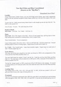
Document - NEW RED, WHITE & BLUE CONSOLIDATED MINE - NOTES ON THE NEW RED, WHITE & BLUE CONSOLIDATED MINE
One handwritten and five typed copies of notes on the New Red, White & Blue Consolidated Mine on the Sheepshead Line of Reef. Notes include locality, depth of shaft, plant, early history, leading mine, prominence, untimely end, gold production and a note referring to the poppet legs from the main shaft which were removed to the Central Deborah Mine. Albert Richardson Collectiondocument, gold, new red, white & blue consolidated, new red, white & blue consolidated mine, notes on the new red, white & blue consolidated mine, the union, new red white & blue mine, mr george lansell, central deborah mine, special edition australian mining standard 1/6/1899, mines dept booklet 'bendigo goldfield' 1936, mines dept annual and quarterly reports, annals of bendigo mining section 1889 - 1935 inclusinve, a richardson -
 Bendigo Historical Society Inc.
Newspaper - JENNY FOLEY COLLECTION: POSE
The Inglewood Hospital was established in 1863. The need arose as previously patients had to travel 30 miles (48km) to Dunolly for treatment.Bendigo Advertiser '' The way we were'' from 2002. Pose: some of the staff at Inglewood Hospital, 1932. From left: R. Newton, V. Hancock, C. Meaney, Matron M. Lyons, I. Innes, M. McLyndon, M. Donaldson and J. Newton. The clip is in a folder. (18 March 2021 The copy of this item was not present in the folder and therefore cannot be recorded against this catalogue sheet).newspaper, bendigo advertiser, the way we were