Showing 174327 items matching "1200-mair-street"
-
 Eltham District Historical Society Inc
Photograph, Looking north near 76 Bible Street, Eltham, c.September 1966, 1966c
Black and white photographic printOriginally located in a Filmpro King Size Prints processing envelope $3.01 Shire of Eltham 9/9/66 and noted as Calrossie Ave area and crossed out Eltham-Yarra Glen Road, Bridge Street to Elsa Court existing conditions mid 1967bible street, road construction, streets -
 Eltham District Historical Society Inc
Photograph, Looking east along Pitt Street, Eltham, c. September 1966, Stebbing Cottage on right, 1966c
Stebbing cottage on rightBlack and white photographic printOriginally located in a Filmpro King Size Prints processing envelope $3.01 Shire of Eltham 9/9/66 and noted as Calrossie Ave area and crossed out Eltham-Yarra Glen Road, Bridge Street to Elsa Court existing conditions mid 1967pitt street, road construction, stebbing cottage, streets -
 Eltham District Historical Society Inc
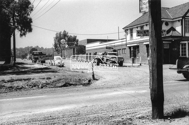
Photograph, Eltham Hotel, corner of Pitt Street and Main Road, c. September 1966, 1966c
Black and white photographic printOriginally located in a Filmpro King Size Prints processing envelope $3.01 Shire of Eltham 9/9/66 and noted as Calrossie Ave area and crossed out Eltham-Yarra Glen Road, Bridge Street to Elsa Court existing conditions mid 1967eltham hotel, main road, pitt street, road construction, streets -
 Eltham District Historical Society Inc
Photograph, Looking west along Brougham Street near No. 101, Eltham, c. September 1966, 1966c
Black and white photographic printOriginally located in a Filmpro King Size Prints processing envelope $3.01 Shire of Eltham 9/9/66 and noted as Calrossie Ave area and crossed out Eltham-Yarra Glen Road, Bridge Street to Elsa Court existing conditions mid 1967brougham steet, road construction, streets -
 Eltham District Historical Society Inc
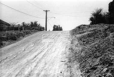
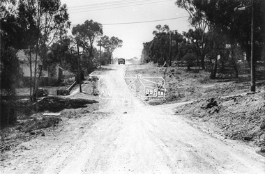
Photograph, Looking north along Bible Street, Eltham near No. 11, c. September 1966, 1966c
Black and white photographic printOriginally located in a Filmpro King Size Prints processing envelope $3.01 Shire of Eltham 9/9/66 and noted as Calrossie Ave area and crossed out Eltham-Yarra Glen Road, Bridge Street to Elsa Court existing conditions mid 1967bible street, road construction, streets -
 Eltham District Historical Society Inc
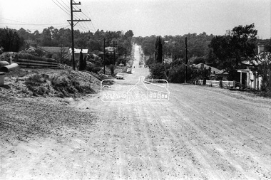
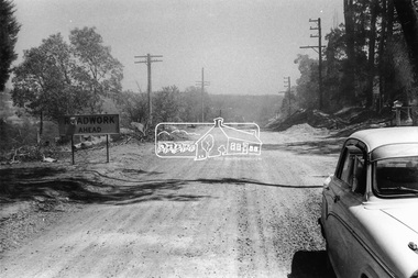
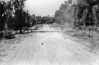
Photograph, Brougham Street, Eltham, c. Sep. 1966
Taken from alongside the Justice Precinct looking east. In the distance on the right hand verge there is a large Eucalyptus tree with a branch growing out over the road. That tree still stands today and is outside No. 102. The two houses on the right are possibly numbers 94 and 96.Black and white photographic printOriginally located in a Filmpro King Size Prints processing envelope $3.01 Shire of Eltham 9/9/66 and noted as Calrossie Ave area and crossed out Eltham-Yarra Glen Road, Bridge Street to Elsa Court existing conditions mid 1967brougham street, eltham, infrastructure, road construction, roads -
 Eltham District Historical Society Inc
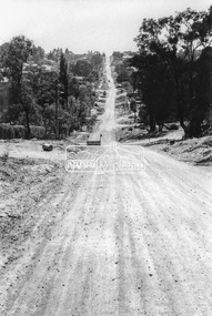
Photograph, Brougham Street, Eltham, c. Sep. 1966
Large tree on left near truck still standing today outside No. 121.Black and white photographic printOriginally located in a Filmpro King Size Prints processing envelope $3.01 Shire of Eltham 9/9/66 and noted as Calrossie Ave area and crossed out Eltham-Yarra Glen Road, Bridge Street to Elsa Court existing conditions mid 1967brougham street, eltham, infrastructure, road construction, roads, bible street -
 Eltham District Historical Society Inc
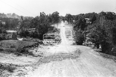
Photograph, Brougham Street, Eltham, c. Sep. 1966
Looking east No. 117. Large tree on left near electric pole still standing today in front of No. 121.Black and white photographic printOriginally located in a Filmpro King Size Prints processing envelope $3.01 Shire of Eltham 9/9/66 and noted as Calrossie Ave area and crossed out Eltham-Yarra Glen Road, Bridge Street to Elsa Court existing conditions mid 1967brougham street, eltham, infrastructure, road construction, roads -
 Ringwood and District Historical Society
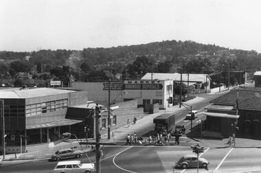
Photograph, Ringwood Street at corner of Maroondah Highway Ringwood - 1969
Black and white photograph of Ringwood St. at corner of Maroondah Highway, 1969. Old post office on right and Loughnans Hill in background. (2 images)Written on back of one photograph (MHW 52): "Dec 1969, Ringwood Street. Taken from clock tower. Old P.O. on right corner. New P.O. occupies vacant block in Ringwood Street." Typed under second photograph (MHW 52a): "Ringwood St at cnr of Maroondah Hwy, 1969. Old Post Office on right and Loughnans Hill in background. The vacant block on Ringwood St can be seen where our 4th Post Office now stands. Old telephone exchange and site of new one can be seen at corner of Charter St. Dec 1969." -
 Kew Historical Society Inc
Photograph, Stuart Tompkins Studio, Electricity Supply Poles, Warrigal Road, Ashwood, 1965
Research provided by Stuart Tompkins Studio, Box Hill, into alternatives for median strip street lighting to be used in Burke Road, Kew. The photographers identified variants in different suburbs appropriate to Kew's needs.The series from which the photograph is drawn provides a snapshot by a commercial photographic studio of each named vicinity in 1965 as well as providing examples of public works infrastructure being commissioned by local government in the 1960s. The photos originally formed part of the Engineering Department's files in the City of Kew before being donated to the kew Historical Society.Electricity Supply Poles, Warrigal Road, Ashwood, 1965. Stuart Tompkins Studio provided this photograph for the Kew City Council. The photograph, taken at the intersection of Warrigal Road and High Street South, Ashwood looks north along High Street Road. The intent of the photograph was to provide the Council with models of electricity supply poles. In the photo, wooden and steel poles can be seen in the median strip. The photograph also includes the shops bordering High Street Road during this period. [There are three copies of this photograph in the Collection.]. Typed inscription on reverse: "Electricity Supply Poles. Photographed for Kew City Council 8/2/65. No.4 Warrigal Road - Ashwood. South of High Street Road looking north. Wooden and steel poles with different brackets in median strip." Studio stamp: "Stuart Tompkins Studio. 547 Station Street, Box Hill. WX1439."electric light poles, public works -- 1960s, civic infrastructure -- 1960s -
 Kew Historical Society Inc
Photograph, Stuart Tompkins Studio, Electricity Supply Poles, Warrigal Road, Ashwood, 1965
Research provided by Stuart Tompkins Studio, Box Hill, into alternatives for median strip street lighting to be used in Burke Road, Kew. The photographers identified variants in different suburbs appropriate to Kew's needs.The series from which the photograph is drawn provides a snapshot by a commercial photographic studio of each named vicinity in 1965 as well as providing examples of public works infrastructure being commissioned by local government in the 1960s. The photos originally formed part of the Engineering Department's files in the City of Kew before being donated to the kew Historical Society.Electricity Supply Poles, Warrigal Road, Ashwood, 1965. Stuart Tompkins Studio provided this photograph for the Kew City Council. The photograph, taken at the intersection of Warrigal Road and High Street South, Ashwood looks north along High Street Road. The intent of the photograph was to provide the Council with models of electricity supply poles. In the photo, wooden and steel poles can be seen in the median strip. The photograph also includes the shops bordering High Street Road during this period. [There are three copies of this photograph in the Collection.]. Typed inscription on reverse: "Electricity Supply Poles. Photographed for Kew City Council 8/2/65. No.4 Warrigal Road - Ashwood. South of High Street Road looking north. Wooden and steel poles with different brackets in median strip." Studio stamp: "Stuart Tompkins Studio. 547 Station Street, Box Hill. WX1439."electric light poles, civic infrastructure - 1960s, public works -- 1960s -
 Kew Historical Society Inc
Photograph, Stuart Tompkins Studio, Electricity Supply Poles, Warrigal Road, Ashwood, 1965
Research provided by Stuart Tompkins Studio, Box Hill, into alternatives for median strip street lighting to be used in Burke Road, Kew. The photographers identified variants in different suburbs appropriate to Kew's needs.The series from which the photograph is drawn provides a snapshot by a commercial photographic studio of each named vicinity in 1965 as well as providing examples of public works infrastructure being commissioned by local government in the 1960s. The photos originally formed part of the Engineering Department's files in the City of Kew before being donated to the kew Historical Society.Electricity Supply Poles, Warrigal Road, Ashwood, 1965. Stuart Tompkins Studio provided this photograph for the Kew City Council. The photograph, taken at the intersection of Warrigal Road and High Street South, Ashwood looks north along High Street Road. The intent of the photograph was to provide the Council with models of electricity supply poles. In the photo, wooden and steel poles can be seen in the median strip. The photograph also includes the shops bordering High Street Road during this period. [There are three copies of this photograph in the Collection.]. Typed inscription on reverse: "Electricity Supply Poles. Photographed for Kew City Council 8/2/65. No.4 Warrigal Road - Ashwood. South of High Street Road looking north. Wooden and steel poles with different brackets in median strip." Studio stamp: "Stuart Tompkins Studio. 547 Station Street, Box Hill. WX1439."electric light poles, public infrastructure -- 1960s, civic works -- 1960s -
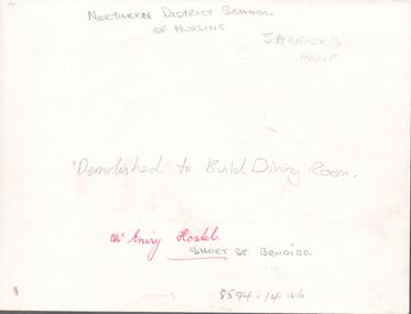 Northern District School of Nursing. Managed by Bendigo Historical Society Inc.
Photograph - Nurses hostel "McEniry"
The Northern District School of Nursing opened in 1950 in to address the issues around nurse recruitment, training and education that had previously been hospital based. The residential school was to provide theoretical and in-house education and practical training over three years. The students would also receive practical hands-on training in the wards of associated hospitals. The Northern District School of Nursing operated from Lister House, Rowan Street, Bendigo. It was the first independent school of nursing in Victoria and continued until it closed in 1989.NDSN McEniry House, Short Street Bendigo, demolished to build dining room. Photo has two names Sander's House and McEniry House, further research required.NDSN McEniry House, Short Street Bendigo, demolished to build dining room.ndsn, nursing -
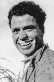 Eltham District Historical Society Inc
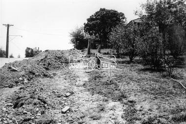
Photograph, Maurie Fabbro at age 20 at Fabbro's farm in Bell Street, Eltham, 1940, 1940
The site of the Fabbro farm (Diamond Creek side land) is now called Barrack Bushlands. It is doubtful that Fabbro's farm holding was ever called Barrak Park, This title is fairly recent after the Shire of Eltham purchased the land, including the last section in 1993/94. About this time the area on the west side of Falkiner Street was purchased by a private developer and developed as housing. The area in Bell Street opposite the Eltham High School was purchased by the State Government is recent years and is called Fabbro Fields. The Fabbro Family operated their farm in Bell Street, Eltham. Maurice Joseph Fabbro (Mario) was born 19 January 1920 and passed away 19 November 20091 black and white photographfabbro's farm, maurice fabbro -
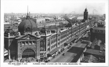 Melbourne Tram Museum
Postcard, Rose Stereograph Co, "Flinders Street Station and the Yarra, Melbourne", late 1920s
Rose Series postcard No. P 1666, titled "Flinders Street Station and the Yarra, Melbourne". This photo is looking southwest from St Paul's Cathedral over the station building along the Yarra river. The St Kilda/Port Melbourne and Queens bridge are in view, but not the Spencer St bridge which was built during the late 1920s. The AW Allen's Limited Confectionary Factory constructed in 1923-24 on Riverside Avenue dominates the landscape on the south side of the river directly behind the dome of the Flinders Street railways station. One very long set of horse-drawn carts can be seen alongside the center entrance to the railway station building in Flinders Street.Yields information about an aerial view of Melbourne late 1920sPostcard - printed real photograph with Rose Stereograph Co. name on the rear.tramways, trams, flinders st station, yarra river, bridges, railways, flinders st -
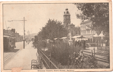 Ballarat Tramway Museum
Postcard, R.E.M Series Melbourne, "Shoppee Square Sturt Street Ballarat", c1915
Photograph - looking east along Sturt Street between Doveton and Armstrong Streets, shows an ESCo tram eastbound. On the right is the Shoppee Square "market" place with awnings open. Wal Jack's note: "Part of the old type trams on the "up" track or north side of Sturt St from Doveton St. Date about 1914-16 period. Iron railings have long disappeared"Yields information about the streetscape of Sturt St and Lydiard Streets c1915.Postcard black and white, divided back, used, REM SeriesSee image 2 for Wal Jack's notes on the image. tramways, trams, esco, sturt st, shoppee's square -
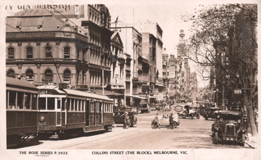 Melbourne Tram Museum
Postcard, Rose Stereograph Co, "Collins Street (The Block) Melbourne Vic.", c1940
Rose Series postcard No. P 3032, titled "Collins Street (The Block) Melbourne Vic.", looking west from near Swanston Street. Has W2 class tram No 522 (City) and part of W class No. 267 in the view. Several cars are waiting to do a hook turn. The Australian Provincial Assurance (APA) Association Ltd tower is in the final stages of construction; completed in 1929. Yields information about Collins Street from Swanston Street 1929cPostcard - printed real photograph with Rose Stereograph Co. name on the rear. UsedHas a letter to "Aunty" from Carolyn in Albury, undated. Has the Ken Magor stamp on the top edge.trams, tramways, tram 522, tram 267, collins st, w class, w2 class -
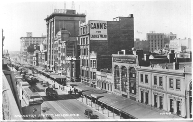 Melbourne Tram Museum
Postcard, Valentine's, "Swanston Street Melbourne", early 1930s
Valentine's postcard titled "Swanston Street Melbourne", Number V49, looking south along Swanston St from Bourke St, Has about 9 W2 class trams in the view. Taken prior to the construction of the Manchester Unity building on the corner of Collins and Swanston Streets. The Capitol building, Cafe Frances, Cann's Ladies Wear, Gasava Health Cooker, Cafe National and Kodak are in the view.Yields information about Elizabeth St, during the early 1930s.Postcard - printed, unused, Valentine Series - with a perforated edge on the left hand side.trams, tramways, swanston st, w2 class -
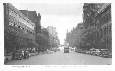 Melbourne Tram Museum
Postcard, Rose Stereograph Co, "Collins Street looking east, Melbourne", late 1940s
Rose Series postcard No. P 2618, titled "Collins Street looking east, Melbourne", Photo shows W2 class tram 543 about to arrive at its Collins and Spencer Streets destination. The return destination has been reset to Kew route 42. Another W2 is in the far distance. The McPherson’s Pty Ltd. building on the left was built 1934-37. Photo late 1940sYields information about the west end of Collins St late 1940s.Postcard - printed real photograph with Rose Stereograph Co. name on the rear.tramways, trams, collins st, w2 class, tram 543, route 42 -
 Melbourne Tram Museum
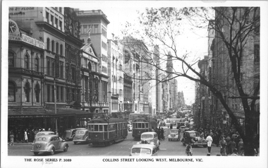
Postcard, Rose Stereograph Co, "Collins Street, looking west, Melbourne", late 1940s
Rose Series postcard No. P 3089 titled "Collins Street, looking west, Melbourne" looking west from Swanston Street with W2 class trams 397 (City, route 47) and 569 (West Preston route 10) in the view. In the background are a further four trams. Alongside 569 is the Safety Zone for the eastbound tram stop. The photo shows a busy traffic and pedestrian scene.Yields information Collins St late 1940s.Postcard - printed real photograph with Rose Stereograph Co. name on the rear.tramways, trams, collins st, w2 class, tram 397, tram 569, route 47, route 10 -
 Melbourne Tram Museum
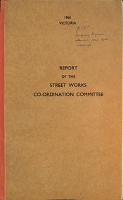
Document - Report, Victorian Parliament, "Report of the Street Works Co-ordination Committee", 1966
Report - titled "Report of the Street Works Co-ordination Committee", includes a table of contents and drawings of street cross-sections. Details the committee members, meetings, terms of reference, suggested legislation, summary of conclusions and recommendations, including previous reports and conference and typical cross sections. Dated 1966, for presentation to the then premier Mr Hamer. Looks at the co-ordination road works by authorities including the tramways.Yields information about an investigation into co-ordination of tram track and other road works.Report - approx 50 pages - side stapled, card covers, cloth side binding."KCP Designing Engineer attended some later meetings"tramways, mmtb, tram tracks, parliament, road works -
 Vision Australia
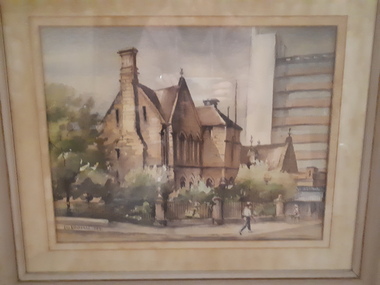
Painting - Artwork, Lin Ditchfield, Sydney Industrial Blind Institution in William Street, 1971
Watercolour by Lin Ditchfield of the Royal Blind Society of New South Wales (formerly the Sydney Industrial Blind Institution) in William Street, Sydney. Built in 1880, the Edmund Blacket designed building was eventually sold in 1971. Located on the corner of William Street and Boomerang Place, the site was keenly sought by developers as the city landscape transformed into high rise office builidings, as evidenced in the background of this painting.1 water colour in beige frameLin Ditchfield 1971royal blind society of new south wales, lin ditchfield -
 Eltham District Historical Society Inc
Negative - Photograph, J.A. McDonald, Eltham, Cecil Street, Sep. 1959
Stabilising junction with Eltham-Yarra Glen Road View looking west across Main Road to Diamond Street railway crossingRecord of various Shire of Eltham infrastructure works undertaken during the period of 1952-1962 involving bridge and road reconstruction projects, sometimes with Eltham Shire Council Project Reference numbers quoted. It was during this period that a number of significant improvements were made to roads and new bridges constructed within the shire that remain in place as of present day (2022). In many situations, the photos provide a tangible visible record of infrastructure that existed throughout the early days of the Shire. The album was put together by or under the direction of the Shire Engineer, J.A. McDonald.infrastructure, shire of eltham, road construction, cecil street, diamond street, eltham, eltham-yarra glen road, main road, railway crossing, 1959-09 -
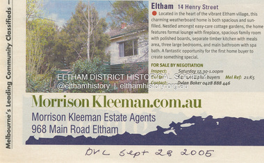 Eltham District Historical Society Inc
Document - Property Binder, 14 Henry Street, Eltham
1. Advertisement: Eltham 14 Henry Street, Morrison Kleeman Estate Agents, Diamond Valley Leader, September 28, 2005eltham, 14 henry street, house, property -
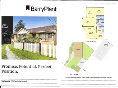 Greensborough Historical Society
Advertising leaflet, Barry Plant Watsonia, 22 Kardinia Street Watsonia, 2019
Sale leaflet for 3 bedroom single storey house, 22 Kardinia Street Watsonia, sold for $642,000 23/11/20202 p. cardboard leaflet printed in colour both sides, folded twicekardinia street watsonia -
 Greensborough Historical Society
Photograph - Photograph - Digital Image, Main Street bridge Greensborough 1970s, 1970s
A colour photograph of the corner of Para Road and Main Street Greensborough in the 1970s, during the duplication and construction of the bridge over the Plenty River.Digital copy of colour photograph.main street greensborough, para road greensborough, plenty river bridge -
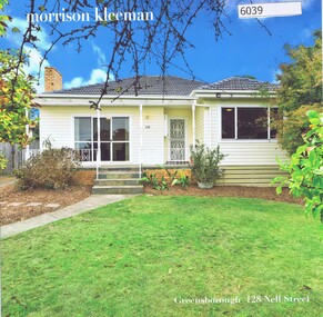 Greensborough Historical Society
Advertising Leaflet, 128 Nell Street Greensborough, 28/05/2018
128 Nell Street Greensborough. 3 bedroom unit. Sold May 2018 for $860,000. Previous sales: November 2005 for $298,000.Real Estate advertising leaflet,1 sheet folded into 4 pages, printed in colour both sides.nell street greensborough -
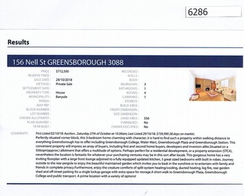 Greensborough Historical Society
Advertising Leaflet, Barry Plant Greensborough, 156 Nell Street Greensborough, 29/10/2018
Real estate advertisement for 156 Nell Street Greensborough, a 3 bedroom house. This house was sold on 29/10/2018 for $713,000. Real estate advertisement black text and colour photographnell street greensborough -
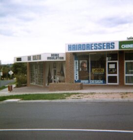 Greensborough Historical Society
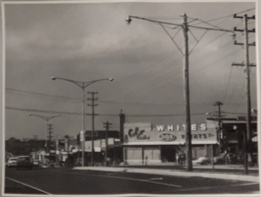
Photographs, Were Street Montmorency shops. 1983-1985, 1983-1985
9 photographs of the Montmorency shopping strip in Were Street and petrol station corner of Rattray Road, taken between 1983 and 1985.9 colour photographs, with 2 copies of some..peter graham, montmorency, were street montmorency, rattray road montmorency