Showing 23764 items
matching matthew-creek
-
 Hume City Civic Collection
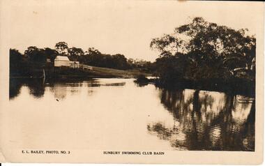
Photograph, 1930-1939
The Sunbury Swimming Club held their events at the Sunbury Swimming Club. The narrow part of the creek was known as 'the Nook' where children had to swim across to get their swimming certificates.A sepia photograph of Sunbury Swimming Club, the building in the background is the ladies change room. Unmounted postcardsunbury swimming club, the nook, sunbury swimming pool, swimming pools, gregor, alex, billinghurst, beryl, francey, sandra, sport, george evans collection -
 Clunes Museum
Photograph - PHOTOGRAPHY, PUBLISHED BY E. BARNETT, SNAPSHOTS OF CLUNES
THE PHOTOGRAPHS ARE; SOLDIERS MONUMENT, PORT PHILIP GOLD MINE, TULAROOP CREEK, TOWN HALL, PANORAMA, QUEEN'S WALK, BRIDGE, POST OFFICE,&TOWN HALL,STATE SCHOOL.9 FOLD OUT SNAP SHOTS OF CLUNES, PRESENTED IN FOLDERlocal history, photography, photographs, clunes township -
 Torquay and District Historical Society
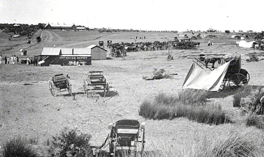
copy photo, Torquay History Exhibition 2016, Produced for exhibition 2016
Photo shows Edward Molyneux's first Hot Water Depot on Spring Creek, Torquay, with the Coffee Palace, which became the Palace Hotel on the hill (Bell Street) in the background.Evidence of the beginnings of a service industry for residents and tourists. Note the absence of any motor vehicles.Black and white copy photo -
 Sunbury Family History and Heritage Society Inc.
Photograph
The photograph was taken when some work was being carried out on one of the arched railway bridges on the Sunbury line. The bridge spans the Jackson Creek and across the Rupertswood viaduct. The bridge over the Rupertswood Viaduct is one of the five significant bridges which span the railway line between Diggers Rest and Clarkfield.A black and white photograph of a bridge with scaffolding erected around the base of the arches.bridges, rupertswood viaduct, railway bridges -
 Falls Creek Historical Society
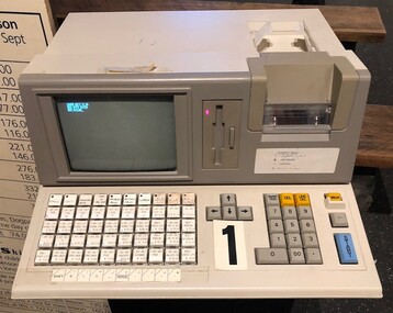
Machine - Cash register and ticket machine
This Cash Register was used for the sale and production of lift tickets, lessons and packages during the 1990s at Falls Creek. The employees who operated the machine were called 'Ticket Tarts'. This item is significant because it was a critical part of the everyday operation of the chair lifts at Falls Creek.A large square cash and ticket machine with buttons and slots for the production of lift tickets. Long cable connected to the back. snow, ski season, ski pass, ski lessons, ticketing, sales -
 Sunbury Family History and Heritage Society Inc.
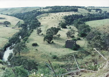
Photograph, Lochton Mill at Bulla, C1980s
The building in the photograph is a present day view of the former Lochton Mill which was built on a bend of Deep Creek in Bulla on 1856 on property owned by Captain William Morrison Hunter. Lochton Mill was one of a few mills that were set-up on the banks of Deep Creek in Bulla and Jacksons Creek in Sunbury.A non-digital coloured photograph of the ruins of a bluestone mill that was built on a bend of a river. It is an elevated view and clearly shows the river's course in the deep valley as well as the surrounding hilly countryside. lochton mill, bulla, deep creek, captain william morrison hunter, milling -
 Falls Creek Historical Society
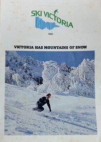
Magazine - Ski Victoria - Victoria has mountains of snow
Ski Victoria Booklet from 1980 featuring 48 pages containing all information required for the ski resorts of Victoria. Falls Creek is featured on pages six to eleven. This item is important as it documents seasonal activities at Falls Creek Alpine ResortMagazine with white front cover, featuring a large square image of a person in black and white ski clothes skiing down hill surrounded by snow and blue sky. Centred above image is Ski Victoria in green with a ski figure in same green, a blue vertical line illustration of the state of Victoria. 1980 is written in smaller black letters underneath with Victoria Has Mountains of snow below text and above image in black capital letters. 'SKI VICTORIA / 1980 / VICTORIA HAS MOUNTAINS OF SNOW'skiing, snow field, snow victoria, tourism victoria, ski victoria, snow, winter, winter tourism -
 Ringwood and District Historical Society
Flyer, Land Sale Advertisement and auction notice - Range View Estate, Ringwood, Victoria - 1920
Advertisement for sale of 150 residential allotments with terms of sale, summary of local features and services, and map showing location and layout of subdivision within the boundary of Mitcham to the west of Ringwood, Victoria. Copy of newspaper advertisement (The Herald, Melbourne, Wednesday 3 March, 1920) refers to public auction date for Range View Estate Ringwood - Saturday, 27th March, 1920.Subdivision includes Deep Creek Road, Range View Grove, Warnes Road, Tarrangower Avenue, Prince Edward Avenue, James Avenue, and White Horse Road, Mitcham. Agents - Phillips & Nicholson, 281 Collins Street, Melbourne, Telephone Central 10907. -
 Hume City Civic Collection
Photograph
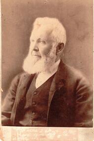
A sepia mounted photographOn back: John Eadie, Esq, JP, FOUNDER OF THE PIONEER FLOUR MILL (WATER WHEEL DRIVEN) / BEN EADIE, SUNBURY / THE FLOUR MILL WAS BUILT ON JACKSON'S CREEK IN 1861, HE ALSO HAD AN ORCHARD AND VINEYARD AND THE WINE CELLAR STILL STANDS 1966eadie, john, pioneer flour mill, water wheels, ben, sunbury, jackson's creek, vineyards, orchards, george evans collection -
 Eltham District Historical Society Inc
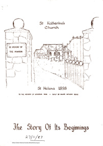
Folder, St Katherine's Church, 1999
Two brochures about the history of St Katherine's Anglican Church and its role in the Anglican Parish of Diamond Creek. One dated by hand 1983 and one dated by hand 2013.5 pages. Two brochures.HG Booklet 26harry gilham collection, st helena, st katherine's church -
 Greensborough Historical Society
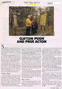
Newspaper Clipping, Jane Freeman, Clifton Pugh and Prue Acton, by Jane Freeman, 20/08/1989
Relationship between Clifton Pugh and Prue Acton based on their common interest in painting. Clifton Pugh lived at 'Dunmoochin' on the Cottles Bridge-Strathewen Road between Hurstbridge and Arthur's Creek.Text and col. photographclifton pugh, prue acton, painters, hurstbridge -
 Greensborough Historical Society
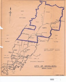
Map, City of Heidelberg, City of Heidelberg, 1962, 02/02/1962
Map of City of Heidelberg showing boundaries of its six wards; North Ward is highlighted, covering Watsonia, Greensborough, part Bundoora, St Helena, Plenty, Yarrambat and Diamond Creek.Blue print mapCity of Heidelberg Scale: 1" to 1 ml. G.M.H. 2.2.62city of heidelberg, heidelberg - maps -
 Greensborough Historical Society
Photograph - Digital Image, View from Sondemeyers, 1925c
Photograph shows a view of Greensborough from 'Sondemeyers Hill' located near the corner of St Helena and Diamond Creek Roads. It looks south towards the township of Greensborough. It is a rural scene.Digital copy of black and white photograph.st helena road, diamond creek road, sondemeyers hill, greensborough -
 Greensborough Historical Society
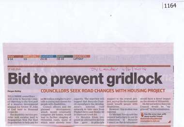
Newspaper clipping, Bid to prevent gridlock, 11/06/2014
Concerns are raised over possible traffic problems when the new housing estate is built on land previously owned by St John of God Accord in Diamond Creek Road Greensborough.News clipping, black and red text.DV Leader and date written on page.st john of god accord, town planning, traffic, greenhills -
 Greensborough Historical Society
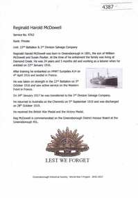
Article, Greensborough Historical Society et al, Reginald Harold McDowell, 1914-1918
A short article about Reginald Harold McDowell and his service in World War 1. Reg McDowell was born in Greensborough and at the time of his enlistment he was living at Diamond CreekOne page, text and colour images.world war 1 project, reginald harold mcdowell -
 Greensborough Historical Society
Letter, Brian Blackburn to Faye Fort, 1942o
Letter from Brian Blackburn to Faye Fort, reminiscing about his childhood in Greensborough living on the property 'Hillside' at 3 St Helena Road [on the Corner with Diamond Creek Road].A personal memory of life in Greensborough, mid 20th century.Text of letter, typescript, 2 pages.greensborough, faye fort, brian blackburn -
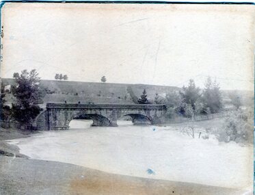
 Eltham District Historical Society Inc
Photograph, Hurstbridge - Construction of new bridge
In early November 1917 the new reinforced concrete bridge across the Diamond Creek at Hurstbridge was officially opened with "some 500 spectators", some who had arrived by train for the occassion.This photo forms part of a collection of photographs gathered by the Shire of Eltham for their centenary project book, "Pioneers and Painters: 100 years of the Shire of Eltham" by Alan Marshall (1971). The collection of over 500 images is held in partnership between Eltham District Historical Society and Yarra Plenty Regional Library (Eltham Library) and is now formally known as 'The Shire of Eltham Pioneers Photograph Collection.' It is significant in being the first community sourced collection representing the places and people of the Shire's first one hundred years.Digital imagesepp, shire of eltham pioneers photograph collection, hurstbridge, bridge, bridge construction -
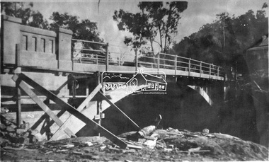
 Sunbury Family History and Heritage Society Inc.
Photograph, 1916 - 1917
The Jacksons Creek is prone to flooding when rainfall is very heavy. The flood pictured in the photograph occurred either in 1916 or 1917 and reached at a level close to the arches on the Macedon Street bridge.A sepia photograph backed on cardboard of a two arched bridge with a river in flood.floods, jacksons creek, macedon street bridge -
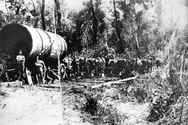 Stawell Historical Society Inc
Photograph, Large Boiler being transported by Horses from the Magdala Mine Site in Stawell to the Heatherlie Quarry
Large Boiler being transported by Horses probably in location of Fyans Creek. Boiler being transported from the Magdala Mine Site in Stawell to the Heatherlie Quarry to replace unserviceable Boiler.stawell industry mining -
Greensborough Historical Society
Newsletter, Greenhills and North Greensborough Progress Association, Community News: official journal of the Greenhills and Nth. Greensborough Progress Association and the Apollo Parkways Progress Association. December 1979, 12/1979
G.A.G.P.A. alive and well, The F5/F18 freeway and Diamond Valley Council, Diamond Creek road... what next??, Chain-sore reaction!!, Kinder news, Diamond Valley Repertory.Newsletter, 4 p.greenhills and north greensborough progress association, greenhills, apollo parkways progress association, apollo parkways -
 Clunes Museum
Container - CHURCH COLLECTION PLATE
USED IN THE FREE PRESBYTERIAN CHURCH. GLENDONALD CHURCH, ONCE ON THE PROPERTY NOW KNOWN AS SNIZORT. CHURCH WAS PULLED DOWN ABOUT 1925 AND THE CONGREGATION TRANSFERRED TO ST. DAVID'S, COGHILLS CREEK.ROUND WOODEN COLLECTION PLATE ON TURNED COLUMN AND BASE, PRE 1884IN PEN ON BASE: COLLECTION PLATE GLENDONALD CHURCH PRE 1884local history, handcrafts, woodwork -
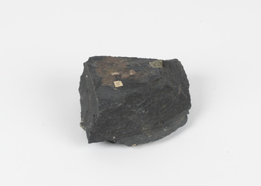 The Beechworth Burke Museum
Geological specimen - Slate with Iron pyrites
This specimen was recovered from Moonambel, Donkey Hill, Victoria. Established in the early 1860's, Moonambel is a small town in the Pyrenees region of the Australian state of Victoria. In the 1850s the location of Moonambel was part of the ‘Mountain Creek’ pastoral run, but in 1860 reports began to appear of a gold-rush at McKinnon’s ‘Mountain Creek’ station. By 1861, a township had developed on the diggings site, and on 21 October 1861 the “municipal district of Moonambel, on Mountain Creek” was proclaimed. The name 'Moonambel' is believed to be an aboriginal word meaning 'hollow in the hills'. Slate is a stone with a fine grain that is noted for its persistent strength and ability to naturally split into slabs. It forms under low temperatures and is most often created from clay. Pyrite is a crystallising compound that occurs naturally in grey and blue-black slate that is colloquially referred to as slate-rust as it resembles regular rust. This specimen is part of a larger collection of geological and mineral specimens collected from around Australia (and some parts of the world) and donated to the Burke Museum between 1868-1880. A large percentage of these specimens were collected in Victoria as part of the Geological Survey of Victoria that begun in 1852 (in response to the Gold Rush) to study and map the geology of Victoria. Collecting geological specimens was an important part of mapping and understanding the scientific makeup of the earth. Many of these specimens were sent to research and collecting organisations across Australia, including the Burke Museum, to educate and encourage further study.Pyrite is iron sulphide (also known as “fool's gold”) which is commonly found in slates.Existing label: 53 /moonambel, slate, pyrite, burke museum, beechworth, indigo shire, beechworth museum, geological, geological specimen, mineralogy, victoria -
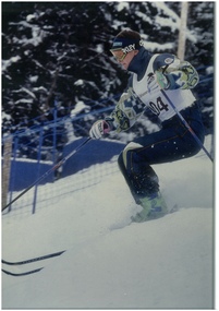 Falls Creek Historical Society
Photograph - Paul Costa in action
Paul Costa is the eldest of four brothers who grew up at Falls Creek, attended school there and at Mt Beauty and were members of the Falls Creek Race Club. He originally raced in alpine skiing but changed to mogul skiing at the age of 16. His first event was the Falls Creek Summit Masters, where he finished second in the Open Class. In 1993 Paul Costa placed fourth at the FIS Freestyle World Championships in Altenmarkt-Zauchensee, Austria. He was selected to represent Australia in the Winter Olympics at Lillehammer in 1994, joining his brother Adrian in that team. During his mogul skiing career, Paul Costa collected 26 World Cup starts. At the end of his competitive career he took up coaching junior teams and was part of the moguls coaching staff for the 2006 Torino Olympics.This image is significant because it depicts an Australian Winter Olympian and former member of the Falls Creek Race Club.Coloured image of Paul Costapaul costa, australian olympians -
 Stawell Historical Society Inc
Photograph, Concongella Home Station 1866
Concongella Home Station. Part of a collection of Photographs by Mr. O.G. Armstrong as commissioned by the Shire of Stawell for the Inter-colonial and Paris Exhibition in Melbourne in 1866. The Concongella Station consisted of 57,000 acres along the Concongella Creek. It was first part of Allanvale, taken up by John Allan in 1841. Allen's right to the 137,000 acres of Allanvale was contested and as a result, the northern section of 57,000 acres was renamed Concongella. Concongella Run, with the homestead on the creek of the same name just east of Stawell, occupied the lands between the later named Deep Lead and Great Western. It was on this station that William McLaughlin a sheep minder discovered gold at Pleasant Creek in 1853. Doctor Blundell held Concongella under licence at this time and through until 1858. The homestead has been gone for many years and only some lonely graves remain at this vicinity. stawell -
 Federation University Historical Collection
Exercise book, Jean Mather, Geology
Brown hardcover exercise book, some handwriting in pencil and some in ink by Jean Mather. These writings describe geological conditions such as faults, goldfields, Reedy Creek (Broadford) and other Goldfields, Maldon Dykes, Bendigo Dykes, Wood's Point, Walhalla-Wood's Point Belt, Sir Donald Douglas Mather, The New Miner's Right (1977), ordivician, gabbro. jean mather, geology, trough faults, bendigo, ballarat, goldfields, dykes, minerolgy, reedy creek goldfield -
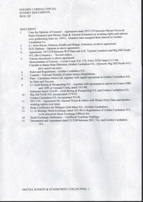 Bendigo Historical Society Inc.
Document - MCCOLL, RANKIN AND STANISTREET COLLECTION: GOLDEN CARSHALTON NO LIABILITY, 1934-1960
Documents; Bundle of documents tied with string, Cert of Inspection for Boiler, Electricity Agreement, Scrip Certificates, Commonwealth Bank Pass Book for (pounds)10 deposit for PMG charges, Lease Agreement, Name change from Big Hill North N.L., Lease agreement Tennant Creek, Insurance documents, Rules. Legal Opinion Document. Golden Carshalton N.L.MCCOLL RANKIN & STANISTREETorganization, business, golden carshalton nl, mccoll rankin & stanistreet -
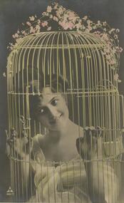 Bendigo Historical Society Inc.
Postcard - GLADYS DEAN COLLECTION: POSTCARD, 1906 - 1908
Postcard with photograph of a smiling young lady dressed in soft draperies in sepia tones. She is inside a birdcage coloured gold, with sprays of pink flowers on top. In the bottom left hand corner is a triangle with the letters PH inside and the numbers 869-1 underneath. On the reverse it is addressed to Mrs Babsillik P O Diamond Creek. The salutation reads Dear Glad.postcard -
 Bendigo Historical Society Inc.
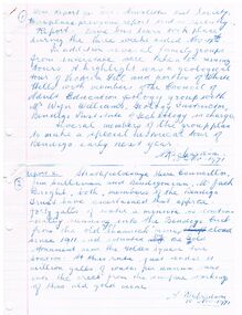
Document - REPORT 1 & 2 HISTORY TOURS
Handwritten copies of Report 1 and Report 2, signed by A. Richardson and dated 15 Nov. 1971. Report 1 mentions five bus tours and tours of Victoria Hill and a portion of White Hills. Report 2 mentions the amount of water running from the old Shamrock Mine into the Bendigo Creek. Also an estimation of the number of gallons per annum.document, report 1 & 2 history tours, historical society, victoria hill, white hills, the council of adult education, mr wyn williams, bendigo institute of technology, a richardson, jim sullivan, mr jack bright, bendigo trust, shamrock mine, gold monument, golden square fire station -
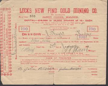 Bendigo Historical Society Inc.
Document - KELLY AND ALLSOP COLLECTION: SHARE CERTIFICATE - LOCKS NEW FIND GOLD MINING CO, 23/01/1911
Document. KELLY & ALLSOP COLLECTION. One Share Certificate issued by Locks New Find Gold Mining Co., Sandy Creek, Maldon, representing 100 shares at 10 shillings each. Capital raised was 18,000 Pounds from 36,000 shares. Certificate No. 910 issued to J.Bright of Bendigo on 23 Jan 1911. Certificate signed by Sidney J.Plain, Manager.Locks New Find Gold Mining Co.business, stockbroker, kelly & allsop, kelly & allsop collection, locks new find gold mining co., maldon, share certificate, j. bright, sidney j.plain -
 Whitehorse Historical Society Inc.
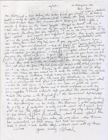
Letter - Correspondence, Sale of Schwerkolt Cottage to the City of Nunawading, 1964
Photocopies: 1. Letter to Mary Schwerkolt from Charles C. Schwerkolt dated 24 September 1964 re sale of property to the City of Nunawading. 2. Letter to Charles C. from estate agent C.E.Carter and Son, estate agent, dated 23 March 1964 confirming verbal agreement with Town Clerk in respect of the property in Deep Creek Road.schwerkolt cottage, city of nunawading, schwerkolt, mary, schwerkolt, charles clarence victor, c.e. carter and son