Showing 7103 items matching "snowy-river"
-
 Bendigo Historical Society Inc.
Document - MALONE COLLECTION: GREETING CARDS, 29/1/1910
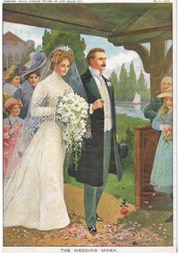
Coloured picture of a bride and groom in a garden house. The bride is wearing a long sleeve, long gown and veil and carrying a bouquet of white flowers with green leaves. The groom is wearing a long black coat, grey trousers with white shirt & waistcoat with gold chain. He is carrying a top hat. A girl, dressed in a blue dress is throwing pink petals before the couple. There are people following the bride & groom. In the background is a lake with a sailing boat on it. At the top is printed 'Horner's Penny Stories 'River of Life' Series No 3. 29. 1. 1910. On the back is written in ink - MP 276. The picture is titled 'The Wedding Morn'.MP276personal effects, greeting cards, malone collection, malone collection, greeting cards, horner's penny stories 'river of life' series no 4 -
 Kew Historical Society Inc
Photograph - Acheron Way, c.1926
Henry Beater Christian (1886-1962) , was a descendant of one of the earliest settler families in Kew. Employed at the Kew Asylum as a 'public servant', he was a skilled amateur photographer, photographing numerous scenes in Kew and on his travels around Victoria. The majority of his photographs date from 1916 to 1929. His finest photographs are housed in two photograph albums. Digital copy of a photograph from page 18 of the 47-page photograph album containing 261 gelatinous silver images, loaned by Diane Washfold with permission given to digitise and hold a copy in our collection. This photograph, dating from c.1926, forms part of a group of photos taken on a bushwalking trip to Marysville, Victoria. John Chapman has written in 'Bushwalking Clubs - A Brief History', about the establishment in Victoria of the first bushwalking club in 1888, and the popularisation of bushwalking during the interwar period. The photographer contrasts the rapid flow of the water of a river through the rapids with the stillness of the surrounding tree ferns and trees."Spur" [illegible ink inscription]henry beater christian (1886-1962), landscape photography, kew (vic.) — yarra river, christian-washfold collection, photograph albums, bushwalking -- victoria, strickland spur track -
 Kew Historical Society Inc
Photograph - Marysville, c.1926
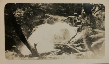
Henry Beater Christian (1886-1962) , was a descendant of one of the earliest settler families in Kew. Employed at the Kew Asylum as a 'public servant', he was a skilled amateur photographer, photographing numerous scenes in Kew and on his travels around Victoria. The majority of his photographs date from 1916 to 1929. His finest photographs are housed in two photograph albums. Digital copy of a photograph from page 19 of the 47-page photograph album containing 261 gelatinous silver images, loaned by Diane Washfold with permission given to digitise and hold a copy in our collection. This photograph, dating from c.1926, forms part of a group of photos taken on a bushwalking trip to Marysville, Victoria. John Chapman has written in 'Bushwalking Clubs - A Brief History', about the establishment in Victoria of the first bushwalking club in 1888, and the popularisation of bushwalking during the interwar period. In this photo, the photographer focusses on a waterfall, probably on the Steavenson River at Marysville, which is surrounded by dense native vegetation. "Marysville" [date illegible]henry beater christian (1886-1962), landscape photography, kew (vic.) — yarra river, christian-washfold collection, photograph albums, bushwalking -- victoria, marysville (vic.) -
 Kew Historical Society Inc
Photograph - Marysville, c.1926
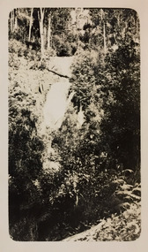
Henry Beater Christian (1886-1962) , was a descendant of one of the earliest settler families in Kew. Employed at the Kew Asylum as a 'public servant', he was a skilled amateur photographer, photographing numerous scenes in Kew and on his travels around Victoria. The majority of his photographs date from 1916 to 1929. His finest photographs are housed in two photograph albums. Digital copy of a photograph from page 20 of the 47-page photograph album containing 261 gelatinous silver images, loaned by Diane Washfold with permission given to digitise and hold a copy in our collection. This photograph, dating from c.1926, forms part of a group of photos taken on a bushwalking trip to Marysville, Victoria. John Chapman has written in 'Bushwalking Clubs - A Brief History', about the establishment in Victoria of the first bushwalking club in 1888, and the popularisation of bushwalking during the interwar period. This photograph is of a waterfall, probably on the Steavenson River, at Marysville. Typically Henry Christian focusses on landscape rather than built structures or people. henry beater christian (1886-1962), landscape photography, kew (vic.) — yarra river, christian-washfold collection, photograph albums, bushwalking -- victoria, marysville (vic.) -
 Kew Historical Society Inc
Photograph - Marysville, c.1926
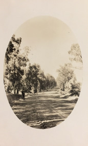
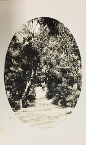
Henry Beater Christian (1886-1962) , was a descendant of one of the earliest settler families in Kew. Employed at the Kew Asylum as a 'public servant', he was a skilled amateur photographer, photographing numerous scenes in Kew and on his travels around Victoria. The majority of his photographs date from 1916 to 1929. His finest photographs are housed in two photograph albums. Digital copy of a photograph from page 21 of the 47-page photograph album containing 261 gelatinous silver images, loaned by Diane Washfold with permission given to digitise and hold a copy in our collection. This photograph, dating from c.1926, forms part of a group of photos taken on a bushwalking trip to Marysville, Victoria. John Chapman has written in 'Bushwalking Clubs - A Brief History', about the establishment in Victoria of the first bushwalking club in 1888, and the popularisation of bushwalking during the interwar period. This photograph is of a stretch of the river at or near Marysville. The photographer has blocked out the edges to create an oval framing of the scene.henry beater christian (1886-1962), landscape photography, kew (vic.) — yarra river, christian-washfold collection, photograph albums, bushwalking -- victoria, marysville (vic.) -
 University of Melbourne, Burnley Campus Archives
Album - 35mm Colour slides, Miscellaneous, 1967
1. "Drive (After) from P.R.I" Feb 67. 2-5. Students learning how to use a machine in the Orchard, 6, 7.Former Nursery, 8. Garden view. Mar 67. 9-14. Emily Gibson beds. Jun 67. 15, 19,26, 27. Plant Research Institute. "June.5.1967" 16, 17. Pruning Day 1`967. 18.Unidentified development on Campus Jul 67. 20. "Nangiloc - Fixed Sprinkler Rock Melons" Oct 67. 22. Yarra River.24. Former Rose garden (now Herbaceous Border.) 28-35 Wilson's Promontory.students, machine, garden views, campus, entrance, plant research institute, old rose garden, nursery, nangiloc, fixed sprinkler, rock melons, wilson's promontory, seed testing station, pruning day, emily gibson beds -
 University of Melbourne, Burnley Campus Archives
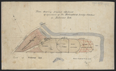
Plan, John S. Jenkins, Plan showing proposed adjustment of boundaries of the Horticultural Society's Gardens in Richmond Park, c.1880-1884
Plan on linen fibre cloth. Shows layout of Burnley bound by Swan St., Yarra River and part of Richmond Park, coloured areas showing proposed area to be added to Park, the old road, shrubbery, new hall, old garden, recent extension and proposed further extension (crossed out in red ink). Scale 4 chains:1 inch. Probably drawn by John S. Jenkins, Town Surveyor, Richmond. Has been photographed so that additional copies can be made. On a CD plus 3 negatives, plus small coloured print. (Also copy glazed and framed for Centenary Exhibition - B92.0540.)john s. jenkins, gardens, richmond, hoticultural society of victoria -
 Melbourne Tram Museum
Document - Photocopy, The Commonwealth Engineer, "Electric Lighting of Melbourne Cable Cars", "Electric Lighting for Melbourne Trams", 1917
Photocopy of an article from The Commonwealth Engineer, dated 1/8/1917, titled "Electric Lighting of Melbourne Cable Cars". Describes the battery system, the number of cars, the use of a motor generator at each depot, the lamps and the system on each car. Also has a start of a short item on the Kalgoorlie Electric Tramways Annual report. Short report in the same journal, 1/11/1917 titled Electric Lighting for Melbourne Trams", about a contract issued by the Tramway Board to the General Electric company for approximately 40,000 pounds. Also has an item about King River hydro electric power and the standardisation of the electrical industry.trams, tramways, cable trams, tramcars, lights, depots, general electric -
 Federation University Historical Collection
Book, Final recommendations Ballarat Study Area Land Conservation Council, Victoria, 1982, 1982
Yellow soft covered report of 95 pages . The contents of the report include: Parks, reference areas, wildlife reserves, water production, hardwood production, softwood production, flora Reserves and Flora and Fauna reserves, bushland reserves, historic area and reserves, rivers and streams, Roadside conservation and Highway parks, Education areas and School Plantations, Lake Reserves, geological reserves, recreation, scenic reserves, agriculture, mineral and stone production, utilities and survey, township land, Uncommitted Land, military training, other reserves and public land. Maps include: The Study area 1: 250 000 Supplementary Mapsland conservation authority, ballarat, endowment plantations, pine plantations, langi ghiran state park, mount buangor state park, enfield state park, ballarat-creswick regional park, rossbridge, black lake, flax mill swamp, dereel lagoon, lake bolac, lake wongan, langi ghiran reservoir, gong gong reservoir, pincotts reservoir, beales reservoir, wilsons reservoir, moorabool reservoir, korweinguboora, korweinguborra reservoir, learmonth bores, sago hill, illabarook reservoir, ballarat water commission, dunneworthy, mount cole, mont lonarch, ben major, waterloo, trawalla, linton, ross creek, canadian, shepherds flat, lal lal, mount doran, raglan, chute, carngham, buninyong, watsons hill, enfield, cape clear, illabrook, rokewood junction, mount warrenheip, nerrina, jubilee, golden stream, australasian deep lead mine, happy valley school, piggoreet, berringa, bulldog, ballarat common, wildlife, water, timber, flora, rivers, geology, agriculture, warrenheip, biodiversity -
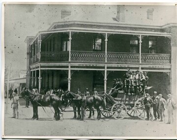 Orbost & District Historical Society
black and white photograph, C 1890s
The first hotel built in Orbost was the Club in 1885 an old wooden place on the corner built for J. A. Petersen of the Mitchell Hotel Bairnsdale, with the licence in the name of Mr Thomas Maguire (stepson of Petersen). William Archer was the proprietor at the time of the photograph. The coach driver was Sam Dyer and the coach is leaving for the goldfields at Combienbar. In June 1889 there was a rush to Mackenzie River, about 28 miles from Orbost, on Twelve Mile Creek. An estimated 80 men rushed the ground, but yields were patchy and large numbers eventually left. They were coming and going almost daily.The Club Hotel was the first hotel built in Orbost and remains a significant building in the town. It was an important hub for the township with many whole town meetings held there.A faded black / white photograph (with two copies) with a horse-drawn carriage loaded with men and the Orbost Club Hotel behind them. The photo is on a grey buff card.on back - " H. Adams. Driven by Sam Dyer - Leaving for the Combienbar Goldfields"orbost-club-hotel combienbar-goldfields -
 Orbost & District Historical Society
black and white photograph, 1901
This photograph was taken at the "old station" at Corringle near Orbost. It was a popular picnic spot. Late in 1857 Mr Thomas T. Stirling took over Corringle Run ("Corringle" means "shallow water"). Mr Stirling and his family came from the wester district - Winchelsea. He settled at the Old Station. A few people were employed at the Orbost Stationb and there was settlement on the Orbost flats, Mr T. T. Stirling held the land from Lake Tyrers to Bemm River as a cattle run. About 1888 he became Secretary of the new Tambo Shire.This is a contemporary pictorial record of rural family life in Orbost in the early 20th century.A black / white photograph of a group of people sitting in a clearing under some trees having a picnic. On the left - hand side is a young boy on a horse.on back - "Old Station"old-station-orbost family-life -
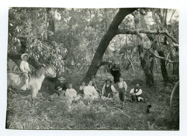 Orbost & District Historical Society
black and white photograph, 1901
The Old Station at Corringle was a popular picnic spot in 1901. Late in 1857 Mr Thomas T. Stirling took over Corringle Run ("Corringle" means "shallow water"). Mr Stirling and his family came from the wester district - Winchelsea. He settled at the Old Station. A few people were employed at the Orbost Stationb and there was settlement on the Orbost flats, Mr T. T. Stirling held the land from Lake Tyrers to Bemm River as a cattle run. About 1888 he became Secretary of the new Tambo Shire.This is a contemporary pictorial record of rural family life in Orbost in the early 20th century.A black / white photograph of a group of early settlers (it appears to be a family group) having a picnic underneath trees. There is a young boy on a horse on the left hand side.on back - "Picnic at the Old Station"family-rural-life-orbost old-station-corringle -
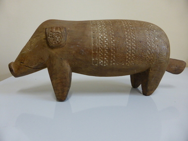 Warrnambool and District Historical Society Inc.
Artefact, Wooden Pig
Oral tradition suggests that this pig came from Papua/New Guinea and was probably in the old Warrnambool Museum which was situated in the Mechanics Institute Building and closed in the 1960s (site of Warrnambool Library today). Illustrations have been found of similar carved pigs originating from the Sepik River area (Tambanum Village) of Papua/New Guinea and of similar items collected early in the 20th century. It is known that the old Museum had a considerable collection of South Sea Islands material but those items appear to have been mainly collected from the Fiji area. If the possible provenance of this item (Papua/New Guinea and old Museum) can be proved then it is a significant item as an example of an indigenous carving which may be more than 60 years old. The pig is very important in Papua/New Guinea as a source of food and a barter/currency item. Otherwise, with provenance not established, the item is useful for displayA brown coloured pig carved out of wood with several cracks on rear and front leg. White coloured incisions on snout, back and ears in patterns reminiscent of Pacific Island indigenous carvings. One ear broken and mended and the other with the top piece missing. Incised with patterns as described abovewarrnambool, old warrnambool museum, papua/new guinea culture -
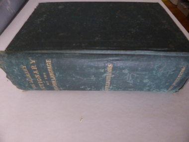 Warrnambool and District Historical Society Inc.
Book, The library dictionary of the Eng language
This dictionary belonged to John Brass, an early settler in South Warrnambool. He owned several block of land and operated a lighterage business with John Young. As a lighterman and boatman he was well-known in Warrnambool. He was drowned in March 1895 while attempting to cross a temporary foot bridge across the Merri River. His house (probably in Stanley Street) was built in 1868 and remained as an interesting example of a lighterman’s cottage until1974. The dictionary probably became the property of W. Macdonald after John Brass’ death. No information has been found on this W. Macdonald. This book is of interest as it belonged to John Brass, an important early settler in South Warrnambool. This is a hard cover book of 974 pages. The cover is green with embossed patterning and lettering on the front cover and gold lettering on the spine. The book has a Preface, a Contents page, the Dictionary entries and an Appendix. There are many illustrations, from engravings on wood, scattered throughout the text. The cloth binding is coming loose and there are several loose pages. The last page is missing. The inscriptions are written in pencil and in blue ink and there are red stamps of John Brass. The cover is stained and faded. ‘John Brass, South Warrnambool, Victoria, Aust- 1893’ ‘June 5 x 6 x 93’ ‘J.Brass, Jetty’ Stamps – ‘John Brass, South Warrnambool’ ‘W.J. Macdonald, Moyston, Dec.23-11-95’ ‘W.J.McDonald’ john brass, history of south warrnambool, w. macdonald (moyston), warrnambool’s maritime history -
 Warrnambool and District Historical Society Inc.
Medal, Warrnambool R.C Regatta
This Warrnambool Rowing Club medal was awarded to the winners of the Society Fours in 1908. The Friendly Society group that won the race was the Manchester Unity Independent Order of Odd Fellows, a benefit society owned by members who assist other members in times of illness or unemployment. Originally founded in Manchester, England, the M.U.I.O.O.F. started in Melbourne in 1840. The Warrnambool branch was founded in 1860. The Warrnmbool Rowing Club was established in 1873, though there had been several boat clubs associated with the Hopkins River going back to the 1850s. No information has been found on R.Russell. This medal is of interest as a memento of a Warrnambool sporting club award in 1908 and of the winner of the award, a Warrnambool group and a member of that group.This circular brass medal has a shield shaped centrepiece with text on both obverse and reverse surrounded by a plain annulus edged with small scrolls. It has a ring at the top.Obverse- W.R.C. Regatta 1908 Reverse SOCIETY FOURS Won by M.U.I.O.O.F.R RUSSELL. A maker's hallmark.warrnambool rowing club, the friendly society, m.u.i.o.o.f. -
 Warrnambool and District Historical Society Inc.
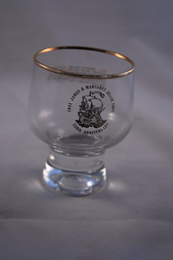
Household, Jellie Souvenir Glass
souvenir glass was produced to commemorate the 1841 arrival in Australia from Ireland of James and Margaret Jellie . They were early settlers in the Warrnambool district, settling first at Port Fairy and then acquiring property along the Merri River in the Warrnambool area. Their children and families were prominent in the 19th and 20th centuries in the Warrnambool district as pastoralists, particularly in the Grasmere area. One son, James had an auctioneering firm in Warrnambool in the late 19th century and two of James’ and Margaret’s granddaughters, Mary and Dorcas. were well-known as teachers at the Warrnambool State School in the 20th century. This glass is of interest as a memento of the Jellie families who have been so prominent in the history of Warrnambool and district.This is a glass tumbler with a rounded base and a rounded body with a gilt rim around the top of the glass. An image of a ship and gold lettering have been impressed on both sides of the glass. ‘James & Margaret Jellie 1841-1991 150th Anniversary’ ‘To commemorate the arrival of James & Margaret Jellie and their children on the Thomas Arbuthnot at Hobson’s Bay, Port Phillip District of New South Wales on 2 October 1841 and their journey to Port Fairy in early 1842’ jellie families, warrnambool, history of warrnambool -
 Eltham District Historical Society Inc
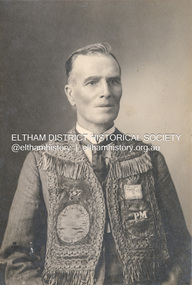
Photograph, The Allan Studio, Thomas Edmund Fielding in his IOOF uniform, c.1901
Independent Order of Odd Fellows (IOOF) https://en.wikipedia.org/wiki/Independent_Order_of_Odd_Fellows Thomas Edmund Fielding (1874-1957) was a significant member of the Diamond Creek Footbal Club during the early 1900s. Son of Robert Fielding (1820-1891) and Jemima Whatmough (1840-1926) and grandson of Plenty River pioneers Robert Whatmough (1815-1887) and Mary Hill (1813-1881) Photo: The Allan Studio, 318 Smith Street, Collingwood Mark Joshua Allan, Photographer operated fropm 318 Smith Street Collingwood from 1887 to 1901thomas edmund fielding, tom fielding collection, independent order of odd fellows (ioof), m.j. allan photographers 318 smith st collingwood -
 Running Rabbits Military Museum operated by the Upwey Belgrave RSL Sub Branch
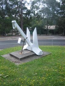
Anchor, Anchor from HMAS Parramatta
HMAS PARRAMATTA had active service during the Vietnam War,escorting the troop transport HMAS SYDNEY to Vietnam in 1965,1968 and 1971. She also served on patrol duties between 1964 and 1966 during the Indonesian Confrontation. In July 1976 PARRAMATTA was diverted to the Indonesian of Bali to provide humanitarian relief following an earthquake which killed over 500 Balinese and injured another 3,000. PARRAMATTA was decommissioned in 1991 as the River Class Destroyer Escorts were replaced by the Adelaide Class Guided Missile Frigates. She was sold to a Pakistani company in 1991 to be broken up.anchor parramatta escort -
 Greensborough Historical Society
Map, Melbourne and Metropolitan Board of Works. Survey Division, MMBW, Yarra 2500 / 12.22. Watsonia North, 1978_03
Melbourne and Metropolitan Board of Works. Yarra 2500 [base map]. 12-22, Parishes of Keelbundora 2856, Municipalities of Whittlesea 239 and Diamond Valley 257. Shows street names, easement sizes, lot numbers, lodged plan numbers, names of prominent features, contour values, creek or river names. Watsonia Railway Station and environs. Prominent streets: Edmund Rice Parade and Macorna Street. Includes Christian Brothers Edmund Rice College and Janefield Special School sites and "proposed future freeway" (now Metropolitan Ring Road).MMBW Map in 1:2500 [scale] series. Cream parchment with green tape reinforcing on edges and punched holes on left edge.mmbw, melbourne and metropolitan board of works, shire of diamond valley, watsonia - maps, bundoora - maps -
 Orbost & District Historical Society
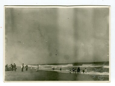
black and white photograph, January 1901
This photograph was taken at the "old station" at Corringle near Orbost. It was a popular picnic spot. Late in 1857 Mr Thomas T. Stirling took over Corringle Run ("Corringle" means "shallow water"). Mr Stirling and his family came from the wester district - Winchelsea. He settled at the Old Station. A few people were employed at the Orbost Stationb and there was settlement on the Orbost flats, Mr T. T. Stirling held the land from Lake Tyrers to Bemm River as a cattle run. About 1888 he became Secretary of the new Tambo Shire.This is a contemporary pictorial record of rural family life in Orbost in the early 20th century.A black / white photograph showing people on a beach with some in the water. those on the sand are dressed formally - men wearing suits and hats, the ladies in long dresses and hats.on back - "Picnic at OLD STATION Jan 1901"orbost-station orbost-family-life recreation -
 Orbost & District Historical Society
black and white photographs, January 1934
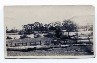
These are photographs taken during the 1934 flood at Orbost. From The Argus (Melbourne) on January 10 1934 "Damage estimated at £500,000 has been caused by the floods in the Orbost district. No loss of life occurred, largely owing to the heroic efforts of rescue parties. Many families spent Monday night on the roofs of houses or in trees, surrounded by deep, rushing flood waters." This 1934 flood was devastating, destroying a section of the 1922 Orbost bridge - the centre span was washed away -. wrecking fences, bridges and roads, dumping silt and debris on the rich river flats and drowning cattle.These photographs are pictorial records of the 1934 floods at Orbost, a significant event in the history of Orbost.Nine small black / white photographs of flood damage,3253.2 on back - "Waters rushing down Princes Highway and....of......where you see the waves" 3253.3 on back - "rushing flood waters over Lochiel Park Bridge approach at the rear of picture 1934"orbost-flood-1934 flood-orbost -
 Ballarat and District Irish Association
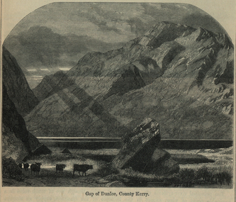
Image, Gap of Dunloe, County Kerry, c1864
The Gap of Dunloe is a narrow mountain pass between Macgillycuddy's Reeks (west) and Purple Mountain (east) in County Kerry, Ireland. It is about 11 km (6.8 mi) from north to south. Within it are five lakes: Coosaun Lough, Black Lake, Cushnavally Lake, Auger Lake, and Black Lough (north to south). These lakes are connected by the River Loe. Between the first two lakes is an old arch bridge called the 'Wishing Bridge' so named because it is said that wishes made while upon it are destined to come true. (http://en.wikipedia.org/wiki/Gap_of_Dunloe)Image of a mountain range in County Kerry, Ireland. Cattle feature in the foreground. ballarat irish, dunloe, gap of dunloe, county kerry -
 Bendigo Historical Society Inc.
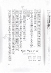
Document - James Tyson
James Tyson was born in Sydney in 1823. Along with his brother the operated a wholesale and retail butchery in 1852, slaughtering cattle from their property near Balranald. He had worked his way up from farm labouring to droving cattle and initially had a property at the junction of the Lachlan and Murrumbidgee Rivers in 1846. With the discovery of gold he began droving cattle to Bendigo in 1851. He extended his holdings throughout NSW, Gippsland and then into Queensland where he died in 1898. Along the way he had become a millionaire.Nineteen pages of research on James Tyson and family.james tyson, tyson family history -
 Kew Historical Society Inc
Photograph, Willsmere Bridge, 1934
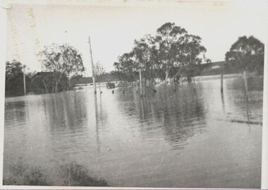
Several boathouses were built in Kew and Fairfield in the late 19th and early 20th centuries. They included Chipperfield’s ‘Moorings’ and floating pontoon. The substantial two-storey house was named the Moorings, and incorporated an upper storey residence. The Moorings was almost washed away in the 1916 floods, and in 1934 almost totally submerged when the Yarra River rose 26 feet in 14 hours. Following the 1934 flood, the house was restored. The floating pontoon, sometimes referred to as a ‘kiosk’ or ‘canteen’, was used to store canoes. Both were removed in 1972 for the construction of the Eastern Freeway.This work forms part of the collection assembled by the historian Dorothy Rogers, that was donated to the Kew Historical Society by her son John Rogers in 2015. The manuscripts, photographs, maps, and documents were sourced by her from both family and local collections or produced as references for her print publications. Many were directly used by Rogers in writing ‘Lovely Old Homes of Kew’ (1961) and 'A History of Kew' (1973), or the numerous articles on local history that she produced for suburban newspapers. Most of the photographs in the collection include detailed annotations in her hand. The Rogers Collection provides a comprehensive insight into the working habits of a historian in the 1960s and 1970s. Together it forms the largest privately-donated collection within the archives of the Kew Historical Society.A view of flooded areas in North Kew in the flood of 1934.Willsmere Bridge. Chipperfields. 1934 floodwillsmere, flood, yarra flood, chipperfields, chipperfields boathouse, north kew -
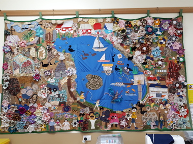 Vision Australia
Textile - Image, 2001 Year of the Volunteer wall hanging, 2001
To celebrate the 2001 International Year of the Volunteer, each Vision Australia Foundation site constructed a wall hanging. These were proudly displayed in the various offices until refurbishments and reduction of physical office space reduced the ability to do this. Various hangings have been stored by volunteers or former staff members, however digital images were secured where possible. Ballarat's wall hanging shows Lake Wendouree and the Ballarat area around it. Mildura's wall hanging shows paddleboats on the Murray River, with grapes, a hot air balloon and a large sun.Cloth banner made by volunteers to celebrate 2001vision australia foundation, volunteers -
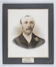 City of Greater Bendigo - Civic Collection
Photograph - Portrait of Councillor Orr, The Yeoman Studios, Ex. Councillor / F. Orr / Eppalock
The district of Strathfieldsaye was proclaimed in 1861 and named a Shire on the 17th September in 1866. It remained a shire until amalgamation in 1994 when it became part of the City of Greater Bendigo. The shire was located 8 km to the south- east of Bendigo and covered an area of 601 square kilometres and extended from the Calder Highway to the Coliban and Campaspe Rivers. The shire's administration centre was in Strathfieldsaye until 1972 when new offices were opened in Kennington. Eppalock Ward is one of three wards in the Greater Bendigo municipality which includes the former Strathfieldsaye Shire. Framed black and white head and shoulder portrait with hand coloured detail. Man with profile slightly to right, walrus moustache, image encircled. Photograph is attached to mount card. Hand written title lower centre.Ex. Councillor / F. Orr / Eppalock / The / Yeoman / Studiosshire of strathfieldsaye, councillor orr -
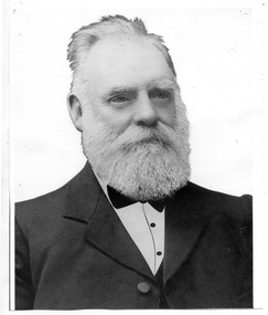 Tarnagulla History Archive
Photograph of John Shields Simpson, circa 1880s
Murray Comrie Collection. Information written by Murray Comrie: John Shields Simpson was born in Scotland in 1831, came to Victoria in 1853 and after mining for a time took up land at what was later to be the Nick O'Time Lead at Poseidon. He took up a store at Newbridge and in 1905 built a hotel alongside the store. Both were severely damaged in floods of the Loddon River in 1909. He was elected to the Tarnagulla Borough Council in 1882 and retained his seat until 1915 when he resigned. He was Mayor of the Borough on five occasions. Monochrome photographic portrait of a bearded man.Accompanying note identifies subject as John Shields Simpson.borough of tarnagulla, john shields simpson, mayor, council, local government, local people, newbridge, store, hotel -
 Bendigo Military Museum
Administrative record - Royal Australian Survey Corps - Central Command Operation Order C/1/61 Northern Territory 1961, DAD Svy, HQ Central Command , Keswick Barracks, SA, 1961
This is a Central Command Operation for the Royal Australian Survey Corps to conduct a Survey Operation in Northern Territory in 1961. The task is to acquire Survey Control for the production of maps coving the following 1:250 000 map areas of Alligator River, Mt Evelyn, Coburg Peninsula, (including the offshore Islands, Melville Island and Bathurst Island. The Operation Order details the tasks for the 6 x Officers (or equivalent) and 34 x OR's (or equivalent) and the support that was allocated including Frigate HMAS Gasgoyne, LSM landing craft, Trucks amphibian (DUKW), Helicopter and Cessna aircraft.A 11 x page foolscap size paper report and 1 x foldout map Annex held together with a paper clip. Two hole punched.Hand written File Number in top RH Corner "101-310-4". Distribution stamp in top LH Corner. Hand written No7 in Top RH Corner.royal australian survey corps, rasvy, fortuna, army survey regiment, army svy regt -
 Bendigo Historical Society Inc.
Map - Laminated map of Lake Eppalock at full capacity. Map 'E'
John Perry Collection. Laminated map of Lake Eppalock at full capacity. Black and white. The dam was built by the State Rivers and Water Supply Commission of Victoria. The dam wall height is 45 metres (148 ft) and the main embankment is 1,041 metres (3,415 ft) long. At 100% capacity the dam wall was designed to hold back 304,651 megalitres (6.7014×10¹⁰ imp gal; 8.0480×10¹⁰ US gal) of water. The surface area of Lake Eppalock is 3,011 hectares (7,440 acres) and the catchment area is 2,124 square kilometres (820 sq mi). The controlled spillway is capable of discharging 8,040 cubic metres per second (284,000 cu ft/s). Lake Eppalock supplies both stock and domestic water to the Campaspe irrigation district. It also serves as a water supply to Bendigo and Heathcote and, in more recent times, Ballarat. The lake is a major attraction for those engaging in watersports, with a number of tourist parks and accommodation facilities available. Permissible activities on the lake include high-speed boating, water skiing, sailing, canoeing, fishing and swimming. The lake's water levels were low for approximately eight years between 2002 and 2010 during a prolonged drought, which restricted the amount of recreational activity until rainfall in the latter half of 2010 returned the lake to 100 percent capacity. Built between 1961 and 1964, Lake Eppalock remains the only water storage on the Campaspe River system.map, eppalock, water, dam, reservoir -
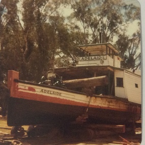 Port of Echuca
Photograph, 1984
The P.S Adelaide was launched on 21st July 1866. It was owned by J.G.Grassie from Poon Boon Station and the Officer Family of Murray Downs Station Swan Hill. The Adelaide was named after the niece of the Officer Bros, Adelaide Blackwood. The shipwright who built her was George Linklater. The Adelaide brought wool and passengers from the wool stations on the Murray and Darling Rivers down to the Echuca Wharf. In 1872 she was sold to David Blair & Sons. She was used to bring timber from the Barmah Forest to the Echuca Wharf. She did this work for the next 80 years. In 1953 she was tied up near the Mill and left. In 1958 she went to Paringa South Australia to work in the sawmill industry again. In 1960 the Echuca Apex Club and The Echuca Historical Society raised enough funds to buy the P.S. Adelaide and return her to Echuca. In November 1963 she was lifted out of the water and placed in Hopwood Gardens as this was thought to be a way of preserving her. In 1984 it was decided to return her to the water to resume work as a passenger vessel. In that time the Port of Echuca and the Echuca Wharf had been restored as a Tourist Precinct. This photograph shows the beginning of the task to return her to the river. It took several weeks in March and April 1984.The P.S Adelaide is extremely significant as it it the oldest known wooden hulled paddle steamers in the world. She was built in Echuca in 1866 and still operates on the Murray River today. She has worked in the Wool Industry, the Timber Industry and the Tourist Industry.Colour photograph of the P.S Adelaide, having been hauled out and dry-docked. The P.S Adelaide is resting on a log platform with a winch attached to the front.p.s. adelaide, grassie, j.g, port of echuca, linklater, george, poon boon station, blair, david, murray river, darling river, logging industry, officer brothers., barmah forest, fulton & shaw, hutchinson, kevin, murray downs station, blackwood, adelaide, 1866, 1984