Showing 498 items
matching gum trees
-
 Mordialloc College Alumni Association Inc (MCAA)
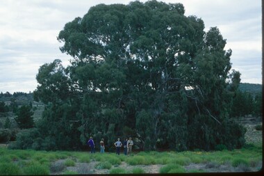
Photograph, 1979 Wyperfeld Old Be-al River Red Gum Tree, 1979
... 1979 Wyperfeld Old Be-al River Red Gum Tree... of the most magnificent River Red Gums in the land. This glorious tree ...1979 - Mordialloc-Chelsea High School students standing in front of “Old Be-al” in Victoria’s Wyperfeld National Park, near Outlet Creek. It has been described as one of the most magnificent River Red Gums in the land. This glorious tree with foliage hanging to the ground escaped the fire of 1959 but not the fire of 1982 that damaged it badly. It lives on but has also suffered from lack of water and is now inaccessible to the public in a reference area. The MCAA has provided this image to the Friends of Wyperfeld National Park. Mordialloc-Chelsea High School students visited the Wyperfeld National park annually for the biology and geography Year 11 school camp.Example of a River Red Gum at Wyperfeld National Park.Digital image reproduced from colour slide.big desert fire 1959, mordialloc-chelsea high school camp, wyperfeld national park, fire 1982, old be-al river red gum -
 Wodonga & District Historical Society Inc
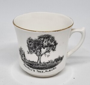
Souvenir - Cup Hovell's Tree, Albury
This souvenir represents the Hovell Tree, a local historic landmark in Albury, NSW. This item is from a collection donated by descendants of John Francis Turner of Wodonga. The Hovell Tree commemorates the exploration and naming of the Hume River (now the Murray) by Hume and Hovell`s expedition of 1824. In 1824, Governor Brisbane asked Hume to join forces with an English sea captain, William Hovell, to go from Lake George to the Spencer Gulf in South Australia. The Hovell Tree, marked by William Hovell on November 17, 1824 was flanked by another tree marked by Hamilton Hume which was destroyed by fire in the 1840's. The river gum was marked by William Hovell when discovering river. Hume and Hovell travelled from the Yass area and after crossing the Murray River where Lake Hume now is, they crossed the Mitta Mitta River and proceeded to Corio Bay, Westernport.This item is representative of souvenirs produced to represent key buildings and historic landmarks in the Albury-Wodonga district.A white cup with gilt trim around the lip. It bears an image of the Hovell Tree in Albury, NSWBeneath image: "HOVELL'S TREE, ALBURY."albury souvenirs, hovell tree, hume and hovell, australian exploration -
 Wangaratta RSL Sub Branch
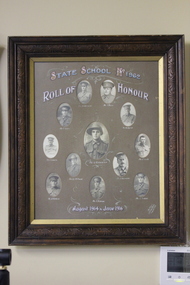
Photograph - Framed photographs, Courtney's Thelma Studio, Wangaratta, WWI Honour Roll State School No 1962 (Dockers Plains)
... of gum trees was planted by schoolchildren and residents, along ...A framed collection of their photographs was donated by Mrs. J.B. Richardson. These were unveiled in a special ceremony at the school on the 17th October 1921. Also in 1921 an Avenue of Honour of gum trees was planted by schoolchildren and residents, along both sides of the Boorahaman road in front of the school. I do not know the exact date most of these trees remain. When the school was closed in 1949, local residents were invited to remove what ever they fancied, so Mr W.B. Richardson chose the two above mentioned items. After the death of both parents - last one in 1977 - Clarice Tobias and her Husband Jim took care of the shield and the photo`s. During 2002 the photo`s were presented to Wangaratta R.S.L. Sub/Branch,Timber frame with ornate edging containing 12 oval framed photographs of men in uniform with writing above and below. At top - State School No 1962 Roll of Honour Below - August 1914 - June 1916 The following soldiers are depicted from top left to right: Pte S Grossman, Pte S Plum, Pte W Byrne, Pte C Smith, Pte B Cummins, Pte H Perkins, Pte F Perkins, Pte A Perkins, Pte A C McDonald, Pte F Vonarx, Pte T Frasca, Pte G Richardson (centre)frasca, francis john vonarx 1981, william thomas byrne 5692, stanley w grossman, alexander mcdonald, richard cummins, sydney plum, leslie richardson, john claude smith, albert perkins, harry perkins, frederick perkins -
 Heidelberg Golf Club
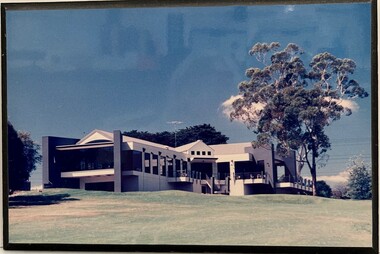
Photograph, Heidelberg Golf Club: Clubhouse and gum tree
... Heidelberg Golf Club: Clubhouse and gum tree... timber. Heidelberg Golf Club: Clubhouse and gum tree Photograph ...Clubhouse and lemon scented gum at Heidelberg Golf ClubColour photo, mounted on black timber.heidelberg golf club, new clubhouse 1998 -
 Heidelberg Golf Club
Painting - Framed Painting, Joy Kirwan, Gum tree at Heidelberg Golf Club by Joy Kirwan, 1978
... Gum tree at Heidelberg Golf Club by Joy Kirwan... Signed "Joy Kirwan" Oil painting with timber frame Gum tree ...Oil painting of a lemon-scented gum at Heidelberg Golf Course, painted by Joy Kirwan. The corner of the old pro shop is on the right, the putting green in foreground.An original painting of part of the HGC groundsOil painting with timber frame Signed "Joy Kirwan"heidelberg golf club, joy kirwan, oil paintings -
 Eltham District Historical Society Inc
Photograph - Digital Photograph, Marguerite Marshall, Hawthorn hedges, Eltham-Yarra Glen Road, Kangaroo Ground, 3 October 2006
Hawthorn hedges are important reminders of Kangaroo Ground's Scottish heritage. They are Registered on the Victorian Heritage Register. They are "historically significant because the planting of hawthorn hedges reflects the adoption of Eurorpean farming techniques by the Kangaroo Ground population in the period following settlement and because the grid pattern of paddocks that the Hawthorn hedges define is very different to today's farm landscapes." Covered under Heritage Overlay, Nillumbik Planning Scheme. Published: Nillumbik Now and Then / Marguerite Marshall 2008; photographs Alan King with Marguerite Marshall.; p21 Hawthorn hedges bordering Kangaroo Ground’s gently rolling farmlands are important reminders of its Scottish heritage and are rare so close to Melbourne.1 As early as the 1840s newly arrived farmers from Scotland planted hawthorn hedges around their properties, to protect crops from the numerous kangaroos and wallabies. Many of these hedges survive today. These farmers had the good fortune to settle some of the most fertile land available for cropping in the Colony of Victoria. At that time the black volcanic soil could sustain an amazing two crops a year. By the mid 1850s, 500 acres (202ha) of wheat were growing in Kangaroo Ground. But the crops were threatened by kangaroos, which were so plentiful, that Surveyor-General, Robert Hoddle, named the district Kangaroo Ground in 1838. As post-and-rail fences proved inadequate barriers for the bounding kangaroos, the Scots planted hawthorn hedgerows as they had done in Scotland. Some also used the hedges to net birds, presumably for the table. Interestingly the farmers in the bordering townships of Panton Hill and Christmas Hills, did not plant hawthorn hedges around their properties. Perhaps it was because by the time they settled in the 1860s and 1870s most of the wildlife had been gunned down by residents.2 The canny Scots planted the hedges on public land outside their own farms, as the hedgerows could spread to about five yards (five m) in width. With this impenetrable barrier Kangaroo Ground’s industrious farmers flourished to gain the economic power that saw the Shire of Eltham governed from Kangaroo Ground for 79 years (1858-1937). The Scots jealously guarded their land, so hard to get in Scotland. That is why they refused to release any of it ‘for local roads to follow easier grades as was the case in surrounding districts where roads generally followed ridgelines or streams’.3 Instead the roads were built in accordance with the magnetic bearings of their first survey in 1847 whether that suited the steep topography or not. This could force traffic to diverge when wet through Greensborough and Diamond Creek. Until 1921, the Eltham-Yarra Glen Road beside Wellers Restaurant, ‘dipped down into the upper reaches of Stony Creek’.4 Later some corners were compulsorily cut for the increasing motor traffic. As late as the 1960s, corners were cut to form sweeping curves above and alongside the Kangaroo Ground Cemetery and opposite the Emergency Operations Centre. In the latter case, the farmers – understanding their hedgerows as important heritage – insisted upon their reinstatement to conform to the altered road alignment. Kangaroo Ground’s ancient manna gums also point to the district’s history and to that of the hedgerows. The Aboriginal people had transformed the original forests into grasslands with the fires they lit to attract kangaroos, (which the Scots were to exclude by planting hedgerows). But the Wurundjeri hunters left the gums (Eucalyptus vimminalis cygnetensis), on the grasslands as ‘stalking trees’ to hunt kangaroos. The hawthorn hedges in Kangaroo Ground were neglected for around 60 years from about the middle of the 20th century. Bushfires had created gaps and the hedgerows were not trimmed. Then in late 2005, local historian Mick Woiwod, formed a group to lobby the Nillumbik Shire to restore the hedges, which could last for many centuries. Some hedges in parts of Britain date back to AD 800.5 Although the original Scottish farmers have gone, the hedges are a reminder of when they flourished in the district, which has changed little in 150 years.This collection of almost 130 photos about places and people within the Shire of Nillumbik, an urban and rural municipality in Melbourne's north, contributes to an understanding of the history of the Shire. Published in 2008 immediately prior to the Black Saturday bushfires of February 7, 2009, it documents sites that were impacted, and in some cases destroyed by the fires. It includes photographs taken especially for the publication, creating a unique time capsule representing the Shire in the early 21st century. It remains the most recent comprehenesive publication devoted to the Shire's history connecting local residents to the past. nillumbik now and then (marshall-king) collection, eltham-yarra glen road, hawthorn hedgerow, kangaroo ground -
 Glenelg Shire Council Cultural Collection
Painting, Julie Kent, Bailey's Rocks, n.d
... . Trunks of trees are ghost gum grey with various greenery... shaped boulders set in amongst a bush backdrop. Trunks of trees ...Oil on canvas. Depiction of Baileys Rocks Casterton. Stacked circular shaped boulders set in amongst a bush backdrop. Trunks of trees are ghost gum grey with various greenery and hints of a blue sky through the trees. Yellow spatters in the in the bottom right quadrant. Black signature bottom right corner. 'Julie Kent' -
 Bendigo Historical Society Inc.
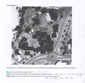
Photograph - Site Diagram of the Bendigo East Primary School
The sheet of photocopied A4 size paper shows an aerial photograph of the Bendigo East State School and the location of significant trees on school property. The trees have been numbered and colour-coded. Blue: Avenue of Honour Sugar Gums, Green: Commemorative Sugar Gums planted on school grounds. Red: Indigenous trees which are not associated with commemorative plantings. Gemma Starr Collectionbendigo east state school, bendigo schools, gemma starr collection, school avenue of honour -
 Phillip Island and District Historical Society Inc.
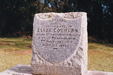
Photograph Album, Kodak, Phillip Island Cemetery, c 1990
The Album was compiled by Nancy McHaffie late 1990's, with the assistance of Edith Jeffery's, with her book "Garden of Memories" and extensive knowledge of Phillip Island. The Cemetery lies back from the road and is surrounded by Manna Gums, rare Peppermint Gums, Blackwoods and other native trees. In all 25 acres of land were set aside as Crown Land in the land settlement of 1868. There are 6.2 acres of wetlands near the cemetery entrance.a) Grave stone of Eliza Coghlan b) Grave stone of Eliza Coghlan with Edith Jeffery standing beside. Eliza was born in West Heath, Ireland. She arrived in Australia on the immigrant ship "Thomas Arbuthnot". She came to Phillip Island as house-keeper to James Duffus and served for 40 years. She was often seen walking to Cowes, about five miles, carrying a heavy turkey. The main road to the cemetery was named in her honour. It has been claimed that Eliza with the oldest subject of Queen Victoria. She died in February 1910, at the age of 113.phillip island cemetery, nancy mchaffie, edith jeffery -
 Federation University Historical Collection
Map, Ballaarat Gold Field, 1861, 1861
... gum tree flat... hill clayton hill soldiers hill golden point gum tree flat ...A party of surveyors camped by Yuille's Swamp (later Lake Wendouree) and surveyed the countryside for a map to be produced by the Geological Survey of Victoria. In November 2004 the Central Highlands Regional Library presented a special edition of 200 copies of the 1861 map reproduced from a copy in their collection. Original 1861 map of Ballarat showing streets and leads. Blue dots indicate gold leads, and red lines indicate auriferous quartz reef and outcrops of quartz veins."Compiled & Drawn from the Survey of Mining Surveyors Davidson, Fitzpatrick and Cowan & the Plans in the Surveyor General's Office by J. Brahe, 21st October 1861. R. Brough Smyth, Secretary for Mines. The Honourable J.B. Humffray, M.L.A. Commr of Mines.”ballarat, map, ballarat east, lake wendouree, survey, mines, robert davidson, ballarat gold field 1861, yuille's swamp, wendouree swamp, little bendigo diggings, gold leads, old post office hill, specimen hill, bakery hill, black hill, dead horse creek, brown hill, pennyweight hill, clayton hill, soldiers hill, golden point, gum tree flat, white flat, poverty hill, chinese village, robert brough smyth, ballarat map 1861, ballaarat vineyard, dead horse gully, deadhorse creek, invermay, black hill flat, gaelic church, police reserve, magpie range, dalton's flat, caadian lead, rifle butts, powder magazine, bathing house, government camp, gold office, chinese, llanberrris, victoria theatre, charlie napier hotel, united states hotel, grape's hoel, clayton's hill, cattleyard hill, free trade hotel, esmond lead, bakery hill, black hill lead, juvenile reformatory, ballarat orphanage, lady barkly lead, triffet's slaughter yard, little bendigo, melbourne road, t. cowan, thomas cowan -
 Ballarat Heritage Services
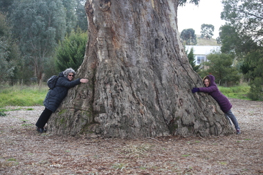
Photograph - Photograph - Colour, Clare Gervasoni, Clare Gervasoni and Ann Gervasoni at the Guildford Big Tree, 2017, 16/07/2017
... A photographs of Guildford's Big Tree - a River Red Gum... guidlford river red gum A photographs of Guildford's Big Tree ...The Big Tree is listed a a tree of State significance on the National Trust's Register of Significant Trees of Victoria for its outstanding size, curious fusion of branches, as an outstanding example of the species and as an important landmark.A photographs of Guildford's Big Tree - a River Red Gum (Eucalyptus camaldulensis). The tre-es is believed to be one of the largest examples of the species in Victoria, and has been recorded as having a height of 30 metre, a canopy spread of 34 metres, and a trunk circumference of 9.35 metres. The tree was already an ancient giant when white settlers first arrived in the 1840s. On Saturday evening, February 28th 2015, just as dusk was falling, Guildford was hit hard by tornado-like winds, felling the big cottonwood tree down by the river, and tearing limbs from the iconic Big Tree, reducing it by an estimated one third. The debris has been cleared since then and the tree seems to have survived its ordeal, though its size is certainly diminished.big tree, guidlford, river red gum -
 Ballarat Heritage Services
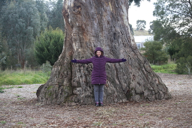
Photograph - Photograph - Colour, Clare Gervasoni, Ann Gervasoni at the Guildford Big Tree, 2017, 16/07/2017
... A photographs of Guildford's Big Tree - a River Red Gum... guidlford river red gum A photographs of Guildford's Big Tree ...The Big Tree is listed a a tree of State significance on the National Trust's Register of Significant Trees of Victoria for its outstanding size, curious fusion of branches, as an outstanding example of the species and as an important landmark.A photographs of Guildford's Big Tree - a River Red Gum (Eucalyptus camaldulensis). The tre-es is believed to be one of the largest examples of the species in Victoria, and has been recorded as having a height of 30 metre, a canopy spread of 34 metres, and a trunk circumference of 9.35 metres. The tree was already an ancient giant when white settlers first arrived in the 1840s. On Saturday evening, February 28th 2015, just as dusk was falling, Guildford was hit hard by tornado-like winds, felling the big cottonwood tree down by the river, and tearing limbs from the iconic Big Tree, reducing it by an estimated one third. The debris has been cleared since then and the tree seems to have survived its ordeal, though its size is certainly diminished.big tree, guidlford, river red gum -
 Eltham District Historical Society Inc
Work on paper - Folio, Register of Significant Trees, Shire of Eltham, c.1993
In 1983, the National Trust advised the Shire of Eltham that it was investigating a number of trees within the shire which had been nominated for recording the Register of Significant Trees of Victoria. The trees involved were described in the Shire of Eltham Historical Society Newsletter No. 29, March 1983 as follows:- 1. Eucalyptus melliadora (Yellow box) . a) An outstanding mature specimen 42 metres high in Laughing Waters Road, Eltham. b) Another mature specimen in Arthurs Creek road, Hurstbridge is reported to be the tree under which the bushranger Robert Bourke was tied after he shot and killed Henry Hurst in 1866 . 2. Quercus robur (English Oak). a) "Donaldson's Oak", Donaldsons Road, Kangaroo Ground was planted by John Donaldson from seed collected from Windsor Great Park in 1878. b) "Wippells Oak". This now misshapen tree is located on the St. Andrews Road near the Kangaroo Ground Fire Station. Its origins may have been similar to Donaldson's Oak, and as a young tree it apparently slipped from higher up the hill during wet weather. Both oaks are of local historical importance. 3. Eucalyptus globulus (Blue Gum). A large mature specimen at the corner of the Kangaroo Ground-St. Andrews Road and Bakehouse Road, Panton Hill. 4. Plantanas acerifolia (Plane tree) A number of trees forming the Avenue of Honour to Eltham's First World War soldiers along Main Road between Dalton and Pitt Streets, Eltham. 5. Pinus canariensis (Canary Island Pine), Pinus pinea, (Stone pine) and Cedras altlantica, (Cedar) These trees are located at the Hurst family graves in the grounds of the Hurstbridge Pre-school Centre. In 1991 the Shire of Eltham introduced controls into its planning scheme to protect sites of architectural, historic or conservation interest and significant trees. The controls were approved by the Minister for Planning and Housing. As advised in the Shire of Eltham Historical Society Newsletter No. 78, May 1991, a planning permit is required to demolish or alter any listed building or to destroy, lop or remove any listed tree. Provision is made for comments to be obtained from the National Trust or Historic Buildings Council in considering any applications. The buildings and trees listed were: Buildings: 250 Bolton Street Eltham (former Walter Withers home) "Rosehill" - Bonds Road Lower Plenty St Andrews Church of England - St Andrews "Montsalvat" - Hillcrest Avenue Eltham St Margarets Church and former vicarage - Pitt Street Eltham Presbyterian Church - Kangaroo Ground Parks and Environment Office (former police quarters) Main Road Eltham Former Court House - Main Road Eltham "Shillinglaw Cottage" - Main Road Eltham "The Robins" - Kangaroo Ground Road Warrandyte Trees: "Donaldsons Oak" - Donaldsons Road Kangaroo Ground Yellow Box - Laughing Waters Road Eltham Yellow Box - Arthurs Creek Road Hurstbridge Wippells Oak - St Andrews Road Kanqaroo Road Pines and Cedar - Hurst family cemetery Greysharps Road Hurstbridge Yellow Box - Parsons Road Eltham A large Blue Gum at Panton Hill has been listed but has recently died (1991). In 1993 work by Council Parks and Environment staff and volunteers resulted in the preparation of a Significant Tree Register listing forty-one trees or groups of trees. According to Shire of Eltham Historical Society Newsletter No. 91, March 1993, a similar number remained to be assessed for inclusion in the register. There is a wide range of indigenous and planted trees on private and public land and extending through the Shire of Eltham from Lower Plenty to Kinglake. Most can be viewed from publicly accessible locations. The Significant Tree Register lists 41 trees or groups of trees throughout the Shire. It contains a wide range of naturally occurring and planted trees. They have been assessed according to eleven criteria including size, age, rarity, historical value and the like. The list includes large old Red Gums at Lower Plenty, historic Oaks at Kangaroo Ground and Mountain Ash at Kinglake. The register includes a set of slides showing each tree. Garry Bartlett of the Council's Parks and Environment Section and Faye Shepherd were extensively involved in establishment of the register (Newsletter No. 93, November 1993). In 1999 Niliumbik planners prepared an amendment to the Planning Scheme to provide protection for approximately 200 of the places listed in the heritage studies and also in the Significant Tree Register commenced by the Eltham Council (Eltham District Historical Society Newsletter No. 127, July 1999. In 2004, The Register of Significant Trees was presented to the Eltham District Historical Society by Nillumbik Shire Council as part of a wider collection of of its memorabilia of the former Eltham Shire Council (EDHS Newsletter No. 159, July 2004. Album of loose handmade paper sheets contained within a handmade slip cover constructed of handcrafted card with encapsulated flora material (flowers, vines, ferns) and tinted. Each page also contains an embedded/adhered fern leaf also tinted with lacqueur or similar, text as appropriate in ink by hand calligraphy. Each page also has a white protective sheet cut to size and adhered to back surface with sticky tape and folded over face of page. Pages variously have photographs and coloured masks adhered with a gum resin. Over time much of this resin has let go and photos/masks have been reattached using acid free archival safe adhesive. 15 pages 41 x 29 cm inclusive of 3 blank pages. Slip case 42 x 30 x 1 cm; face cover of slip case has broken off at left hand margin as insufficient depth/flexibility for contents.arthurs creek road, blue gum (eucalyptus globulus), canary island pine (pinus canariensis), couties road, donaldsons oak, donaldsons road, eltham, english oak (quercus robur), eucalyptus melliodora, graysharps road, hurst tree, hurstbridge, ironbark (eucalyptus tricarpa), ironbark hill, kangaroo ground, kangaroo ground-kinglake road, laughing waters road, panton hill hotel, panton hill, parsons road, significant trees register, sonia van bodegraven, sonjart, stone pine (pinus pinea). atlantic cedar (cedrus atlantica), wippells oak, yellow box gum (eucalyptus melliodora), yellow box gum -
 University of Melbourne, Burnley Campus Archives
Album - Colour prints, Stuart Miller, Garden Views, 1983
Colour photographs. (1) Herbaceous Border 1984-5 (pre-Rainforest) #277. (2) View Admin Building from between Emily Gibson Beds. (3) Admin Building. (4) View of Bull Paddock, Dairy and beyond from roof of Admin Building. (5) Rear of Burnley. Tennis Court replaced by PSL 4-6 (DA) (6) Shady Walk Mondograss (Ophiopogon japonicus) Umbrella Grass (Cyperus alternifolius) (David Aldous). (7) Admin Building and Student Amenities Building. (8-10) Luffmann Ponds. (11) Frank's/Rock Point. (12-13) Oak Lawn. (14) Oak Tree lawn on reverse "Please return to Stuart Miller, Burnley College." (15) E. cladocalyx. (16) The Victorian College of Agriculture & Horticulture-Burnley Campus. U. procera to the left E. cladocalyx to the right DA. (17) Sugar Gum E. cladocalyx Burnley Gardens 1989 DA. (18) Burnley College in background DA Crack Willow in winter. (19) Tree unidentified. DA (20) DA View of trees behind Luffmann Ponds. (21) View of Burnley Gardens Pinus canariensis to the left Agathis robusta centre and sequoia sempervirens to the right DA. (22) Students in Citriodora Courtyard. (23) View of Emily Gibson Beds from roof of Admin Building. (24) Admin Building from Oak lawn. Annotated by David Aldous and Stuart Miller. herbaceous border, administration building, emily gibson beds, bull paddock, dairy, tennis court, shady walk, luffmann ponds, oak lawn, david aldous, stuart miller, student amenities building, sugar gum, citriodora courtyard, lily ponds -
 Port of Echuca
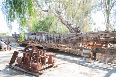
Paddlesteamer hull, Westgood & Air, Success, 1877
The PS Success was built in Moama in June 1977 by GB Air for Westwood & Air. It was built to tow barges of cargo along the Darling and Murray rivers, as well as running as a passenger boat from Swan Hill to Mildura during 1915-16. The Success was the last paddlesteamer actively working on the river when she performed several rescue voyages to flood bound properties along on the Darling River, rescuing sheep and a large cargo of wool. The vessel ended her working life in 1957 and was put up on the bank at Ned's corner, 80km west of Mildura. In 1996, the Pollard family donated the vessel to the Riverboat Historical and Preservation Society of Mildura with plans to restore her to her former glory. This project became increasingly difficult for the dedicated volunteers to handle and the Port of Echuca took ownership in 2009 in the hopes that further restoration work can be done at the Port. The Succes is currently on static display at the northern end of the Port of Echuca. The PS Success had a long, colourful history towing barges on the Murray River and in particular in the Mildura, Wentworth and Ned's Corner regions. She was the last paddlesteamer to be working on the river system right up until the 1956 floods towing the barge Vega, where at one point both boat and barge smashed into trees on a wild, uncontrolled journey downstream where she was damaged and later lay stranded on Ned's Corner.Composite timber hull, 3-inch red gum planks on angle iron frames. Carvel built with counter stern and straight stem. Originally had a round keel and a pair of 35hp engines. Success paddle steamers, echuca boat builders, westwood & air -
 Bendigo Historical Society Inc.
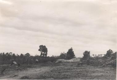
Photograph - Napoleon Reef Gold Mine Battery Site, 1936
The Napoleon (BML) gold mine (1932) was located beside McDougall Road, Golden Gully, between Martin and Hattam Street. It had a depth of 921 feet. It was one of the latest and most lavish of Bendigo's mines. Plant and equipment were electrically driven. The four-compartment shaft, extra large by goldfield's standards, measured 17 feet 6 inches by 5 feet 2 inches and was cement lined below 900 feet instead of being red gum boxed as was the usual practice. The workshop was equipped to carry out all repairs for the equally lavish BML mines on the Nell Gwynne and Carshalton reefs. (The Gold Mines of Bendigo, Book 2, Arthur Victor Palmer)Significant to mining history of Bendigo.Black and white photograph. Image shows flat, open landscape with four large eucalypt trees in centre of image. Four men working with shovels on left hand side of image, one man with wheelbarrow and dog alongside. Wooden framed structure on right hand side. Written in pencil on back of photograph: ' Battery excavations started 22/9/36' and 'excavations started'.napoleon gold mine, napoleon reef gold mine -
 Bendigo Historical Society Inc.
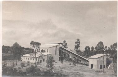
Photograph - Napoleon Mine Battery, 1936
The Napoleon (BML) gold mine (1932) was located beside McDougall Road, Golden Gully, between Martin and Hattam Street. It had a depth of 921 feet. It was one of the latest and most lavish of Bendigo's mines. Plant and equipment were electrically driven. The four-compartment shaft, extra large by goldfield's standards, measured 17 feet 6 inches by 5 feet 2 inches and was cement lined below 900 feet instead of being red gum boxed as was the usual practice. The workshop was equipped to carry out all repairs for the equally lavish BML mines on the Nell Gwynne and Carshalton reefs. (The Gold Mines of Bendigo, Book 2, Arthur Victor Palmer)Significant to mining history of Bendigo.Black and white photograph: landscape view of mine sheds. Battery shed fully completed with trestleway to another shed. Trees in background. Written in pencil on back of photograph: 'completed battery 5/12/36'napoleon gold mine, napoleon reef gold mine -
 Hymettus Cottage & Garden Ballarat
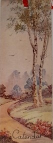
Work on paper - Bookmark, Calendar Bookmark
... Gum Tree... Calendar Gum Tree Printed on front the word Calendar ...John Sands were the first stationers established in Australia c. 1837 and by the 1920s were producing a range of greeting cards and bookmarks.John Sands were the first stationers established in Australia c. 1837 and by the time of the Great War the firm was producing a range of greeting cards as well as bookmarks such as this calendar bookmark.Printed on front the word Calendar and on the reverse the John Sands Hourglass logo.john sands, bookmark, calendar, gum tree