Showing 1520 items matching " sand"
-
 Queenscliffe Maritime Museum
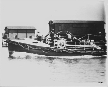
Photograph - Photo of the Lifeboat QUEENSCLIFFE after launching, Photograph of lifeboat QUEENSCLIFFE, circa 1930's
The QUEENSCLIFFE lifeboatLifeboatsblack & white photograph of the Lifeboat QUEENSCLIFFE post launch, probably after the early 1930'sReverse - "Fisherman's Pier (demolished about 1955 - lifeboat shed before moved to new pier because of sanding up - [c.1947 or 49] - P&H (Ports and Harbour) shed on left (on S arm of Fisherman's Pier) - see 1986-086"community information, the queenscliffe lifeboat -
 Puffing Billy Railway
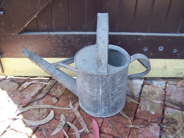
Watering Can with a large spout
Watering Can A watering can, with a large spout. Its former use is currently no known, but may have been used for oil, chemicals or even sand.Historic - Railway Permanent Way and Works - track equipment - Watering CanWatering Can with a large spout made of tin puffing billy, watering can -
 Tatura Irrigation & Wartime Camps Museum
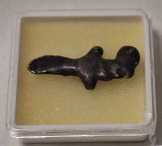
Memorabilia - Dagger, WW2
Made by the brother of Bruno Weinmann. The camp children collected toothpaste tubes, melted them down and poured into moulds carved out of wood, sand and clay.Small zinc dagger made from a melted toothpaste tube and cast into a mold. Housed in a 4 cm square plastic container with lid and sitting on yellow foam.bruno weinmann, dagger, toothpaste tubes -
 Bialik College
Photograph (Item) - Kinder Days
Kinder children at Bialik are shown at various events, partaking in sand play, birthday celebrations, and reading time. c1993 For inquiries or access contact [email protected], 1993, school, jewish school, bialik college, photographs -
 Bendigo Historical Society Inc.
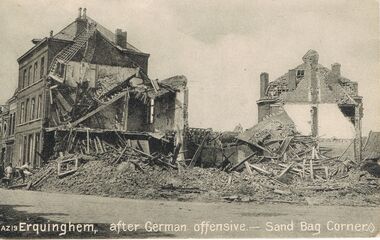
Postcard - ACC LOCK COLLECTION: ERQUINGHEM, AFTER GERMAN OFFENSIVE - SAND BAG CORNER, POSTCARD, 1914-1918
Postcard, WW1, B&W image of two ruined buildings at so called Sand Bag Corner at Erquinghem after a German offensive. Three figures and a wheelbarrow on the left. Published by J.M.Hamilton & Coy. Sydney, Australia Copy AZ 19 See also copy 1401.106postcard, postcard, ww1, france, erquinghem, sand bag corner -
 South Gippsland Shire Council
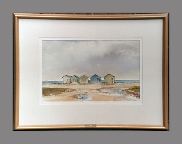
Painting, Watercolour, After the Rain, 1989
Framed watercolour titled: "After the Rain" by Julie Lundgren Coulter. Set in cream window mount with engraved brass plaque affixed to lower edge. Brown painted wood frame. Features five bathing boxes on beach with grey clouds in sky and water pools in sand. -
 The 5th/6th Battalion Royal Victoria Regiment Historical Collection
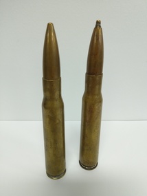
Weapon - Explosive Ordnance-Inert, 12.7mm Rounds
2 x 12.7mm rounds ( .50 cal ) with projectiles attached. One has been put into a tap and dye and has a threadded head, possibly for ysing as a second cocking handle on a Browning M2 MG, the other has had the base sanded to remove any markings SL 4 ? inert 400 june 94 wark vc club, ammunition, 12.7mm, m2, 50 cal, inert -
 Lakes Entrance Historical Society
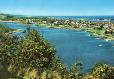
Postcard - Lakes Entrance, Engelander John & Co Pty Ltd, 1980c
Panoramic view of Lakes Entrance taken by Melbourne firm for West Germany A.F.K. International Publishers of world's most famous beauty spotsColour postcard with serrated edge, of the township, situated between Cunninghame Arm and North Arm. Boats moored at jetties and beside boat ramps in North Arm. Photo taken from Kalimna Heights. Dredged sand dumped in North Arm bight. Lakes Entrance VictoriaLakes Entrance, Victoria, Australia (on back) waterways, topography, township -
 Lakes Entrance Historical Society
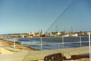
Photograph - Lakeside, Holding George, 1984c
Part of a series of seven colour photographs taken from same spot on the same dayColor photographs showing progress of extension to lakeside at the West boat Harbour, taken from the car park, showing many moored vessels. In the foreground the sand dredged from other areas and dumped in order to extend the car park and lakeside walkways. Lakes Entrance Victoriawaterfront, boats and boating -
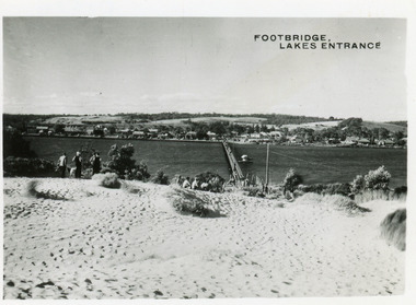 Lakes Entrance Historical Society
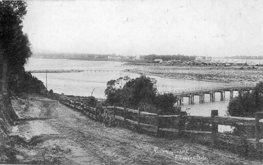
Postcard - Township, 1950c
2 copies 6 x 9Black and white small format postcard of footbridge over Cunninghame Arm. It shows people on bare sand dunes in foreground boat moored beside bridge, motor vehicles parked along retaining wall on North shore with town buildings in background. Lakes Entrance VictoriaFootbridge Lakes Entrancebridges, waterways, township, people -
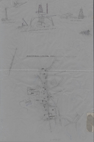 Bendigo Historical Society Inc.
Document - DEVONSHIRE & MUNGO MINES - LOCATIONS OF THE DEVONSHIRE & MUNGO MINES
Tracing of streets, school sand heaps and dam at Eaglehawk titled Devonshire & Mungo Mines. At the top of the page is sketches of the chimney of the 'Big 180', Old Chum Mine, United Devonshire and Old St Mungo Mines. Also, a sketch of a windlass, whip & remains of whim. Eaglehawk.mine, gold, devonshire & mungo mines, devonshire & mungo mines, locations of the devonshire & mungo mines, eaglehawk, chimney of the big 180, old chum mine, united devonshire, old st mungo -
 Lakes Entrance Historical Society
Photograph, Glenice Soderlund, Lady Harriet barge, Lakes Entrance Victoria, 1/06/1989 12:00:00 AM
Colour photograph showing Lady Harriet barge moored at wharf in Cunninghame Arm mast and rigging intact. Bullock Island and sand dunes in background Lakes Entrance Victoria. Also an enlarged colour lamenated photograph almost identical 04673.1 29 x 19.5 cmbarges, boats and boating -
 Lakes Entrance Historical Society
Postcard, Lakes Entrance 1930, 1930 c
Black and white postcard showing view from top of hill north of Lakes Entrance shows North Arm with west end of town Cunninghame Arm and sand dunes in distance. Track in foreground Myers Street known as Allens Hill in 1930 Lakes Entrance Victoriatownship, waterways, roads and streets -
 Flagstaff Hill Maritime Museum and Village
Leisure object - Tobacco Pipes, circa 1869
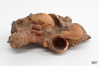
This concretion of tobacco pipes is one of a group of artefacts in the McCulloch Collection. It was recovered from the shipwreck of the Victoria Tower. The pipes may have been amongst the ship's cargo but could have been included in a passenger’s personal effects. The object is now one of the shipwreck artefacts in Flagstaff Hill’s Mc Culloch Collection, which includes items recovered from the wrecks of the Victoria Tower (wrecked in 1869) and Loch Ard (wrecked in 1878). They were salvaged by a diver in the early 1970s from the southwest coast of Victoria. Advanced marine technology had enabled divers to explore the depths of the ocean and gather its treasures before protective legislation was introduced by the Government. The artefacts were donated to Queensland’s Department of Environment and Heritage Protection (EHP) by a passionate shipwreck lover and their locations were verified by Bruce McCulloch. In 2017 the Department repatriated them to Flagstaff Hill where they joined our vast collection of artefacts from Victoria’s Shipwreck Coast. The Victoria Tower: - The three-masted iron clipper ship was built in 1869 in Liverpool, England, as a passenger and cargo ship for the Australian trade. She was named after one of the two towers of the British Houses of Parliament and owned by the White Star line. The Victoria Tower sailed under the command of Captain Kerr from Liverpool towards Melbourne on her maiden voyage. She carried 34 passengers and 16 crew plus a general cargo including bottled beer, slates, iron pipes and hardware. She was almost at her destination when she was wrecked on 17th October 1869 at Point Impossible, west of Thompsons Creek, Breamlea. The shipwreck is a very popular dive site.The artefact is an example of cargo or personal items on board a ship in 1869. It provides a reference point for classifying and dating similar items. The artefact is significant for its association with the clipper ship Victoria Tower, which is listed on the Victorian Heritage Register as S698. The Victoria Tower is recorded as the most intact historic shipwreck accessible between Point Lonsdale and Cape Otway. The Victoria Tower is one of only seven shipwrecks in Victoria that have had more than 100 objects recovered from them reported as a result of the Commonwealth Amnesty held in 1993-94.Concretion of clay tobacco pipes. Bowls and stems of several broken orange tobacco pipes are joined together in ac irregularly shaped clump of concretion from the sea. The concretion also contains stones, shells, sand and particles of seaweed. It was recovered wreck of the ship Victoria Tower.flagstaff hill, warrnambool, maritime village, maritime museum, flagstaff hill maritime museum and village, shipwreck coast, great ocean road, shipwreck artefact, wreck dive, mcculloch collection, bruce mcculloch, white star line, victorian heritage register, clipper ship, victoria tower, captain kerr, shipwreck victoria tower, migrant ship 1869, cargo ship 1869, iron clipper, british clipper ship, 1869, cargo imported to australia, pipe cluster, concretion of pipes, pipe, ceramic pipes, tobacco pipes, smoker's pipes -
 Melbourne Tram Museum
Newspaper, Newcastle Herald Newspaper, "Trams may give electric shocks", 13-6-2000
Newspaper cutting about the possibility of electric shocks from tramcars due to the application of too much sand on the tracks, and not allowing the return current. Tram becomes insulated.Yields information about the possibility of electric shocks from tramcars if excessive sand applied to tracks.Newspaper cutting from the Newcastle Herald, NSW newspaper titled "Trams may give electric shocks""NH 13.6.00"trams, tramways, melbourne, electrical engineering, tramcars, electricity, safety -
 Stawell Historical Society Inc
Photograph, Stawell Cricket Club 1913
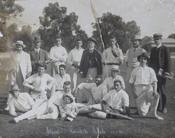
Cricket Stawell Club 1913. Taken at Central Park with Curators Cottage in background. There is a granite sand bike track outside the grass oval inside a picket fence.B/W Photo: with 16 People in three rows, Back Row Standing, centre row seated, front row laying down man on right is wearing cricket pads and has a bat over one leg, the man on the right has a young child in front of him. 8 of th emen are wearing hats.Stawell Cricket Club 27.1.13stawell sport -
 Flagstaff Hill Maritime Museum and Village
Instrument - Hourglass
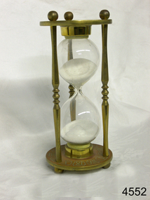
An hourglass or sandglass is an instrument for measuring a defined time and can be used perpetually by simply turning it over immediately the top bulb empties. The clear blown glass is shaped into two equal sized bulbs with a narrow passage in the centre and contains uniform sized sand or glass particles in the lower bulb. The width of the neck regulates the constant flow of the particles. The glass is held in a stand with top and bottom of equal shape and size. Hourglasses can measure an infinite variety of time by gauging the size of the particles, the shape and size of the bulbs and the size of the passage between the bulbs, thus measuring hours or minutes or even seconds. Generally an hourglass sits between discs of wood at the ends, which are joined by long wooden spindles between the ends and tightened by screw caps. The length of time can be adjusted by adding or removing sand particles. The use of the marine sandglass (or hourglass) has been recorded in the 14th century in European shipping. A one minute sandglass was used in conjunction with the ship’s log for ‘dead reckoning’, (see below) that is, for measuring the ship’s speed through the water. They were also used to regulate ringing the ship’s timetable; for example a 4 hour sandglass was used for the length of the sailors’ watch, and a half hour timer for taking of readings for the ship’s log; the ship’s bell would be rung every half hour. It was usually the role of the cabin boy to watch and turn the sandglasses over at the exact time of them emptying their upper chambers and to ring the ship’s bell. Hourglasses have been used historically for many hundreds of years. Some have been used for timing church sermons, in cooking, in industry and at sea. Even today they are used for measuring the cooking time of eggs and timing a player’s turn in games such as Boggle and Pictionary. The sandglasses at sea were gradually replaced in the late 1700’s to early 1800’s by the more accurate chronometers (marine clocks) when they became reliable instruments. DEAD RECKONING (or Deduced Reckoning) Dead reckoning is the term used to describe the method of calculating the ship’s position from its speed and direction, used in early maritime travel, mostly in European waters. Both the (1) speed and the (2) direction of travel were recorded on a Traverse Board at half-hourly intervals during a helmsman’s watch of 4 hours. The navigator would record the readings in his ship’s log, plot them on his navigational chart and give his updated course directions to the next helmsman on watch, along with the cleared Traverse Board. This was a very approximate, but none-the-less helpful, method of navigation. The wooden Traverse Board was a simple pegboard with a diagram of a compass with eight peg holes along the radius to each of the compass points, plus a grid with ascending half hours in the left column and increasing ship’s speed in knots in a row across the column headings, with a peg hole in each of the intersecting cells. A number of wooden pegs were attached to strings on the board. By placing one peg consecutively in the direction’s radius hole, starting from the centre, and the speed holes when the half hourly reading was taken, a picture of speed and direction for the whole 4 hour watch was created. (1) To measure the ship’s speed a one minute hourglass timer was usually used to measure the ship’s speed through the water and help to calculate its longitude. A rope, with knots at regular standard intervals and a weight such as a log at the end, would be thrown overboard at the stern of the ship. At the same time the hourglass would be turned over and a seaman would start counting the number of knots on the rope that passed freely through his hands as the ship travelled. When the timer ran out the counting would be stopped. A timer of one minute (one-sixtieth of an hour), knots spaced one-sixtieth of a nautical mile apart, and simple arithmetic easily gave the speed of the ship in nautical miles per hour ("knots"). This would be recorded every half hour. The speed could however be inaccurate to the travel being affected by ocean currents and wind. (2) To calculate the ship’s direction a compass sighting would be recorded each half hour.Marine hourglasses or sandglasses were used from around the 14th to 19th century during the time of sailing ships. This hourglass is representative of that era, which is during the time of the colonisation of Australia. Hourglass or sandglass; an instrument used to measure time. Two equal sized clear glass bulbs joined with a narrow passage between them, containing equal sized particles of sand grains in lower bulb. Glass sits in a brass collar at each end, in a frame comprising 3 decorative brass columns or posts, each attached top and bottom, using round screw-on feet, to round brass discs. Disc have Roman numerals for the numbers 1 - 12 pressed into their inner surfaces and hieroglyphics on the outer surfaces. Roman numerals on inner surface of discs " I II III IV V VI VII VIII IX X XI XII " Hieroglyphics impressed on outer surface of discsflagstaff hill, warrnambool, shipwrecked coast, flagstaff hill maritime museum, maritime museum, shipwreck coast, flagstaff hill maritime village, great ocean road, horology, hourglass, hour glass, sandglass, sand glass, timing instrument, dead reckoning, deduced reckoning, finding latitude at sea, sandglass with hieroglyphics and roman numerals, hourglass with hieroglyphics and roman numerals, brass hourglass -
Glenelg Shire Council Cultural Collection
Photograph - Photograph - Bridgewater Hotel, Victoria, n.d
Black and white photo of the Bridgewater Hotel, front view. Double storey building, front verandah, tin roof, chimney each side of building. Three windows on first floor, window either side of door, ground floors, picket fence with gate; sand dunes behind.Back: 'BRIDGEWATER HOTEL' -printed in capitals, blue biro -
 Queen Victoria Women's Centre
Photograph, c.1996
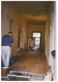
Colour photograph. First floor corridor. Looking south to the women's lounge and what is the Fitted or Work office in 2015. The left door entrance was into the former matron's office of the hospital. Man in blue shirt sanding the floor faces away from the camera. Taken during restoration inspection.building construction, historic buildings -
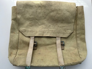 Moorabbin Air Museum
Equipment (item) - Haversack WW1 Pattern
-
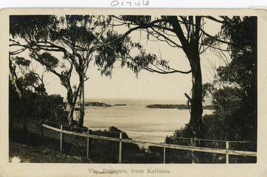 Lakes Entrance Historical Society
Postcard - The Entrance
Black and white postcard of the man made entrance through the sand hummocks, taken from Kalimna cliff top. In the foreground native vegetation on the cliff top behind simple timber and wire netting boundary fence topped with a single strand of barbed wire. Lakes Entrance VictoriaThe Entrance from Kalimnawaterways, topography, islands -
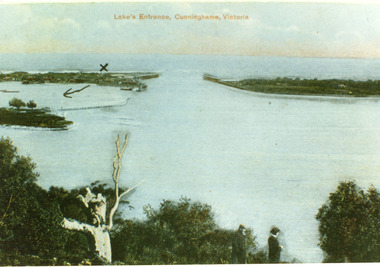 Lakes Entrance Historical Society
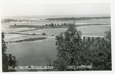
Postcard - The Entrance, 1900c
Also copy tinted postcard 10 x 15Coloured post card of the man made entrance through the sand dunes, taken from Jemmys Point. It shows the works and settlement at the entrance, Bullock Island and groynes to direct flow of lake waters towards entrance. Two men standing on Jemmys Point. Lakes Entrance VictoriaLakes Entrance, Cunninghame, Victoriaislands, waterways, topography -
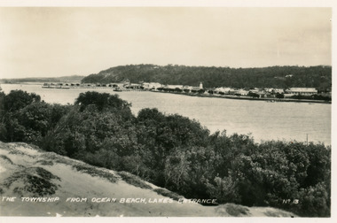 Lakes Entrance Historical Society
Postcard - Township, 1935c
Black and white small format postcard of town, taken from south shore of the lake. It shows a panoramic view of Esplanade and buildings, jetties, Great War Memorial cypress trees, Jemmys Point and Kalimna Heights in background. Vegetation of sand hummocks in foreground. Lakes Entrance VictoriaThe Township from Ocean Beach Lakes Entrance No 13memorials, vegetation, waterfront, township -
 Lakes Entrance Historical Society
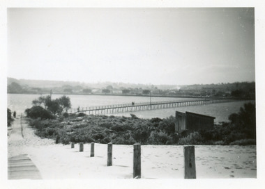
Photograph - Footbridge, Todd Della, 1945c
Black and white photograph of the footbridge over the Cunninghame Arm. It shows a sand covered wooden ramp leading from footbridge to ocean, shed in scrub covered southern shore, two people on bridge, distant view of town and trimmed memorial Cyprus trees. Lakes Entrance Victoriabridges, waterways -
 Lakes Entrance Historical Society
Postcard - Bullock Island, The Lakes Studio, 1920c
One black and white copy 17 x 25Black and white postcard showing North Arm Bridge, Bullock Island and foot bridge northern end of piers at entrance to Bass Strait and sand dunes. Left foreground shows power pole and water bore and telephone poles along Princes Highway Lakes Entrance Victoria.The Entrance, Bullock Island, Lakes Entranceislands, bridges, waterways, topography -
 Lakes Entrance Historical Society
Postcard - Cunninghame township, Lakes Entrance Victoria c1905, 1905c
Also Black and white copy 12.5x20.5 Good condition P01146.1Black and white postcard of Cunninghame township, mud flats, North Arm Bridge, wooden bridge to mud island in North Arm, post and rail fence, beside main road. Road appears to have a sand surface. Bicycle leaning against fence. Lakes Entrance Victoriabridges, fences, topography, roads and streets -
 Ballarat Tramway Museum
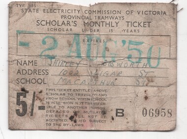
Ephemera - Ticket - Scholars Montly ticket - 1950, State Electricity Commission of Victoria (SECV)
Cloth backed off white paper ticket with black printing, used for a Scholar's under 15 years, monthly tickets with a large rectangle for an expiry date stamp and printed conditions of use. Has space for the student's name, address and school to be written in. Used by Shirley Bosworth. The ticket was found behind a tram sand box and was most likely lost by the holder. It was in an almost inaccessible position and recovered when the sand box had to be removed for maintenance, along with other tickets. Was designed to be folded.Yields information about the use of SEC Ballarat Scholar tickets.Orange cloth backed paper ticket- 5/-. Scholar's monthly ticket, dated to expire 2 Aug 50. Ticket No. 06958trams, tramways, tickets, school tickets, scholar tickets, sec tramways -
 Phillip Island and District Historical Society Inc.
Photograph, Phillip Island Bridge
Glimpse of arched bridge between trees from left to right of photograph. Scrubby low bush in foreground. Tranquil water behind and under bridge to Newhaven sand beyond.Glimpse of bridge, San Remolocal history, photographs, bridges, san remo, black & white photograph, mona condrick -
Federation University Historical Collection
Book, The College of Domestic Economy Prospectus, 1944, 1914
The College of Domestic Economy was located at 450 Lonsdale Street, Melbourne. In 1914 the superintendent was Miss M. Sandes. The Training College and University of Melbourne proveded instructors for some courses.Brown soft covered book of 32 pages. Includes four photographs of work on display.college of domestic economy, m. sandes, donald clark, a,c. mountain, jean greig, constance ellis, marjory robertson, mabel sandes, e eddie, mrs storer, miss vieusseux, miss williams, mr graham, mr varey, prof berry, prof spencer, dr bull, prof osborne, university of melbourne, training college, elementary drawing, designs, form and colour, first aid, care of children, applied hygiend, dr jean greig, dr eileen fitzgerald -
 Bendigo Historical Society Inc.
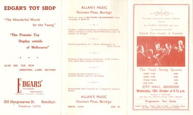
Document - MUSICAL VIVA SOCIETY OF AUSTRALIA, CITY HALL, BENDIGO, 18 Ocotber, 1967
4341. Musical Viva Society of Australia, City Hall, Bendigo. The Music Advancement Society of Bendigo Presents the FOURTH CONCERT 1967 series by arrangement with Musical Viva Society of Australia. The Vegh String Quartet: Sandor Vegh - violin, Sandor Zoldy - violin, Georges Janzer - viola, Paul Szabo - cello. Wednesday, 18th, October, 8-15pm. Photo of quartet on cover. President: E Beilharz. Joint Hon. Secs. Madge Edgar, Emily Bright. Programme Ten Cents. Annual Meeting, Friday 24th November, Committee Room, City Hall. All Subscribers are invited to attend. Advetisements: Hesse Bros, Edgars, Allan's Music.entertainment, theatre, music advancement society of bendig, musical viva society of australia, city hall, bendigo. the music advancement society of bendigo fourth concert 1967 series musical viva society of australia. vegh string quartet: sandor vegh - violin, sandor zoldy - violin, georges janzer - viola, paul szabo - cello. wednesday, 18th, october, 8-15pm. photo of quartet on cover. president: e beilharz. joint hon. secs. madge edgar, emily bright. annual meeting, 24th november, committee room, city hall. advetisements: hesse bros, edgars, allan's music.