Showing 1292 items
matching urban
-
 Federation University Art Collection
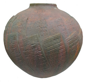
Ceramic - Artwork - Ceramics, High Rise by Grant Finck, c1987
Grant FINCK Grant Finck graduated from the Victorian College of the Arts in 1991. He started a professional career as a sculptor and ceramicist in the late 1970s, From 1993 Finck coordinated and was a design participant in a regionally based urban design program. From 1996 he has completed a substantial number of public sculpture commissions. In 1987 Grant Finck has a solo exhibition at the Switchback Gallery, Churchill.Earthernware dry glaze orb pot.ceramics, jan feder memorial ceramics collection, gippsland campus, grant finck, churchill -
 Wodonga & District Historical Society Inc
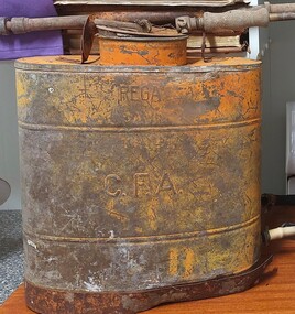
Equipment - Fire Fighting Knapsack, REGA Products Ltd, c1945
The spraying units were manufactured in Australia by REGA Products. Ltd. in 1926. They established themselves as leaders in the production of agricultural and horticultural spraying machines, including smaller knapsacks. Knapsacks were quickly adapted to a range of applications and were widely used by the C.F.A (Country Fire Authority). They were also widely used for defence during World War II. REGA was later purchased by the Garrard family and still operate as part of Garrads Pty Ltd. This sprayer was one of the units used by the C.F. A. in Wodonga. The Country FIre Authority was established in 1945 following a Royal Commission into the 1939 Black Friday fires which recommended a single firefighting authority for country Victoria, bringing together the Bush Fire Brigades, Country Fire Brigades and Forest Commission. The first fire brigade, the Wodonga Urban Fire Brigade was formed in 1891 and registered in May 1893. Since that time its volunteers have provided ongoing support to the Wodonga and District communities through events such as urban fires, bushfires and other emergency situations. This item is representative of the Wodonga Country Fire Authority and its many volunteers.A knapsack sprayer designed to be used for spraying insects. The unit includes brass fittings, leather straps and a spray arm and nozzle attached. It was also adapted to be widely used by firefighters.On front: REGA / C.F.A. Around lid: REGA SPRAYERSrega sprayers, cfa region 24, cfa volunteers, cfa wodonga, wodonga urban fire brigade, fire fighting equipment -
 Rutherglen Historical Society
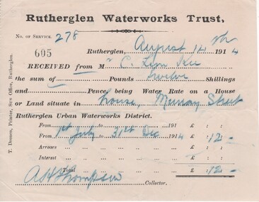
Financial record - Receipt, T. Drenen, 14/8/1914 (Exact)
It is believed that the C. Lim Kee who was paying these rates was Charles Lim Kee. According to the Rutherglen Sun September 11, 1896 he was starting a business known as the Cash Bakery in premises previously occupied by Conrad Huhs. In 1903 he moved to new premises next to the Bank of Victoria. By 1908 he had a shop and rooms in Main Street, and houses in Wallace Street and Murray Street. Part of a collection of business documents found under the floor of a building in Main Street when it was being renovated. At that time the owner was Don Chambers, and the premises was occupied as the Chambers Riteway Supermarket. The location (134 Main Street) is currently (2022) occupied by Miegel’s Pharmacy Rutherglen. Receipt from Rutherglen Waterworks Trust for water rates for a house in Murray Street. The form is printed on paper with hand written details reproduced with carbon paper.,"Rutherglen Waterworks Trust, No. of service 278. [receipt no.]: 605. Rutherglen, August 14th 1914. Received from Mr C. Lim Kee the sum of --- Pounds twelve Shillings and --- Pence, being Water Rate on a House or Land situate in house, Murray Street Rutherglen Urban Waterworks District. From 1st July to 31st Dec 1914." Signed A.H. Thompson, Collector.lim kee, rutherglen waterworks trust, water rates, business documents, 134 main street, chambers riteway supermarket -
 Kew Historical Society Inc
Photograph, J E & B L Rogers, Stables, 'Roseneath', Pakington Street, c.1959
This work forms part of the collection assembled by the historian Dorothy Rogers, that was donated to the Kew Historical Society by her son John Rogers in 2015. The manuscripts, photographs, maps, and documents were sourced by her from both family and local collections or produced as references for her print publications. Many were directly used by Rogers in writing ‘Lovely Old Homes of Kew’ (1961) and 'A History of Kew' (1973), or the numerous articles on local history that she produced for suburban newspapers. Most of the photographs in the collection include detailed annotations in her hand.The Rogers Collection provides a comprehensive insight into the working habits of a historian in the 1960s and 1970s. Together it forms the largest privately-donated collection within the archives of the Kew Historical Society.'Roseneath' was constructed in stages in the I850s by John Ambrose Kitchen, a soap-maker. In 1870 the brick house received an N.A.V. of £60 while in 1885 it was purchased by Edward John Dunn, a geologist. A new wing was built at the right side of the house and several rooms as well as the coach house, loft and groom's quarters were added. In 1903, during Dunn's ownership, the property was described as having eight roorns. The garden is recorded as having been designed by Baron von Mueller who was the Government Botanist from 1853. Source: City of Kew Urban Conservation Study, 1988"32"historic houses -- kew (vic.), roseneath -- pakington street -- kew (vic.) -
 Kew Historical Society Inc
Map, MMBW, MMBW Town of Kew, 1910-21
The Melbourne and Metropolitan Board of Works (MMBW) was established by an act of the Victorian Parliament in 1890 to prepare for and to implement a sewerage and water reticulation system across what was then inner Melbourne, its surrounding and middle distance suburbs, including Kew. The MMBW was disbanded in 1991.The map collection of the Kew Historical Society has at its core the historic maps assembled and originally stored in the City Engineer's Department of the City of Kew. These include maps in a number of scales. The vast majority of maps were produced by the MMBW in the first two decades of the twentieth century, and are solid working maps, backed by linen for durability. These maps are historically significant to Kew, the City of Boroondara and to the history of the development of state utilities in Victoria. A number of the Kew maps have additional details added by former municipal officers, including the levels reached by various floods. As these were working documents, information was added to them long after the period of their initial production and distribution.Early map of the Town of Kew, created after 1910, at a scale 440 ft to 1 inch. The 'assembled' map by the City of Kew Engineer's Department includes scaled down copies of The Melbourne and Metropolitan Board of Works maps, Nos. 39, 40, 64, 65, 66, 67, 68, and 117. The map covers the entirety of the Town of Kew, bordered on its north and west by the River Yarra, by Burke Road in the East and Barkers Road in the south. The map shows the extent of urban development by that time, prominent institutions and the outlines of built structures in the municipality. TOWN OF KEW / SCALE 400 FEET TO 1 INCHmelbourne & metropolitan board of works, mmbw maps, mmbw plans, town of kew, cartography -
 Kew Historical Society Inc
Map, MMBW, MMBW Plan No.40 Collingwood & Kew, 1900-1910
The Melbourne and Metropolitan Board of Works (MMBW) was established by an act of the Victorian Parliament in 1890 to prepare for and to implement a sewerage and water reticulation system across what was then inner Melbourne, its surrounding and middle distance suburbs, including Kew. The MMBW was disbanded in 1991.The map collection of the Kew Historical Society has at its core the historic maps assembled and originally stored in the City Engineer's Department of the City of Kew. These include maps in a number of scales. The vast majority of maps were produced by the MMBW in the first two decades of the twentieth century, and are solid working maps, backed by linen for durability. These maps are historically significant to Kew, the City of Boroondara and to the history of the development of state utilities in Victoria. A number of the Kew maps have additional details added by former municipal officers, including the levels reached by various floods. As these were working documents, information was added to them long after the period of their initial production and distribution.Early map of part of the Borough of Kew, created in the first decade of the twentieth century, at a scale 160 ft to 1 inch. The map covers what was then the south western section of Kew, bordered on its north by Studley Park Road, in the west by Walmer Street and the River Yarra, by High Street South and Princess Street in the East and Barkers Road in the south. The map shows the extent of urban development by that time, prominent institutions and the outlines of built structures in the municipality. Contour lines and historic flood levels were added in ink to the map at a later stage.MELBOURNE AND METROPOLITAN BOARD OF WORKS / PLAN NO. 40 / COLLINGWOOD & KEWmelbourne & metropolitan board of works, mmbw maps, mmbw plans, borough of kew, cartography -
 Melbourne Tram Museum
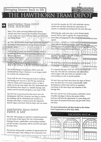
Document - Report, Minister of Transport, "Bringing history back to life - The Hawthorn Tram Depot", Aug. 1998
Report - consultation document titled - "Bringing history back to life - The Hawthorn Tram Depot", 7 A4 sheets, photocopied, outlining the joint Public Transport Corporation (PTC) and Urban Land Corporation (ULC) study into the future of the Hawthorn Tram Depot. Includes a site plan or location map, consultation proposals, news release from the Minister for Transport - Mr Robin Cooper - dated 12/8/1998 and background document providing details of some of the heritage trams - both the PTC and the TMSV. Two copies held - one stapled. Imaged as a pdf file.trams, tramways, hawthorn depot, heritage, minister for transport, tram depot -
 The Beechworth Burke Museum
Photograph, Unknown
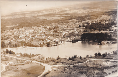
Aerial view of Lake Sambell, Beechworth with town views. Lake Sambell is a beautiful Victorian recreation lake and urban park with a unique history. It was created in the mid-1800s by the Rocky Mountain Mining company during the gold rush era and used as a mining site until the early 1900s, which brought Europeans into the area. It was turned into a reserve for residents in 1920 and is considered an icon of Beechworth as it represents the development of the community, human endeavour, and the spirit of the landscape.This photograph represents Lake Sambell with town views.Black and white reproduced rectangular photograph print on paper.Reverse: Stampbeechworth lake, lake sambell, aerial photo, construction, australian landscape, #beechworth, victoria -
 The Beechworth Burke Museum
Photograph, 1960
Taken in 1960, depicted is an aerial view of Lake Sambell and the surrounding township. Lake Sambell is a beautiful Victorian recreation lake and urban park with a unique history. It was created in the mid-1800s by the Rocky Mountain Mining company during the gold rush era and used as a mining site until the early 1900s, which brought Europeans into the area. It was turned into a reserve for residents in 1920 and is considered an icon of Beechworth as it represents the development of the community, human endeavour, and the spirit of the landscape.This photograph represents what Lake Sambell looked like in 1960.Black and white reproduced rectangular photograph print on paper.lake sambell, #beechworth, beechworth 1960s, lake, victoria, australian landscape, mining, rocky mountain mining company -
 The Beechworth Burke Museum
Photograph, 1960
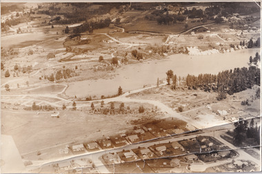
Taken in 1960, depicted is the construction of Lake Sambell, looking west across the lake. Lake Sambell is a beautiful Victorian recreation lake and urban park with a unique history. It was created in the mid-1800s by the Rocky Mountain Mining company during the gold rush era and used as a mining site until the early 1900s, which brought Europeans into the area. It was turned into a reserve for residents in 1920 and is considered an icon of Beechworth as it represents the development of the community, human endeavour, and the spirit of the landscape.This photograph represents additional construction to Lake Sambell as a recreational reserve.Black and white reproduced rectangular photograph print on paper.beechworth lake, lake, lake sambell, construction, #beechworth, australian landscape, beechworth 1960s, victoria -
 Eltham District Historical Society Inc
Photograph, Barak Bushlands Reserve, Eltham, March 2003, 2003
This area is urban and wetlands west of the Eltham gateway approach near the bridge over Diamond Creek and forms part of a walking trail. On 15 August 2004, the Shire of Nillumbik officially named the area "Barak Bushlands" as part of its commitment to Aboriginal reconciliation. The naming day memorialised the one hundred and first anniversary of the death of the last full-blood Yarra Aboriginal leader, William Barak. Source: Aboriginal reconcilation events in Nillumbik, Ken Eckersall, 2006.Digital scan from borrowed photobarak bushlands reserve, eltham, walking trail -
 Kew Historical Society Inc
Flyer - 60 Pakington Street, Kew
Subdivision plans and real estate flyers/brochures reveal a number of aspects of urban development and history. The Kew Historical Society's collection of these plans, as well as advertisements extracted from magazines, cover key aspects of community development and architectural history of Kew and Kew Eat as well as surrounding suburbs. While most of the plans in the collection were gifted to the Society by the former City of Kew, a number of other plans and advertisements have been donated by individuals, of which this is an example. Single page illustrated flyer, advertising 60 Pakington Street, Kew for sale. Annotation in pen and ink at right.neville collection, 60 pakington street -- kew (vic.), real estate advertisements -- kew (vic.) -
Kew Historical Society Inc
Flyer - 45 Pakington Street, Kew
Subdivision plans and real estate flyers/brochures reveal a number of aspects of urban development and history. The Kew Historical Society's collection of these plans, as well as advertisements extracted from magazines, cover key aspects of community development and architectural history of Kew and Kew Eat as well as surrounding suburbs. While most of the plans in the collection were gifted to the Society by the former City of Kew, a number of other plans and advertisements have been donated by individuals, of which this is an example.Single page illustrated real estate flyer advertising 45 Pakington Street, Kew for sale by auction. Annotation in pen and ink at rightpeter neville, real estate advertisements -- kew (vic.), 45 pakington street -- kew (vic.) -
Kew Historical Society Inc
Plan - Tramway Estate, Camberwell North, 1937
Subdivision plans and real estate flyers/brochures reveal a number of aspects of urban development and history. The Kew Historical Society's collection of these plans, as well as advertisements extracted from magazines, cover key aspects of community development and architectural history of Kew and Kew Eat as well as surrounding suburbs. While most of the plans in the collection were gifted to the Society by the former City of Kew, a number of other plans and advertisements have been donated by individuals, of which this is an example.Single page subdivision plan listing properties for sale in the Tramways Estate, Camberwell North. The large estate was bounded by Doncaster Road, Burke Road, Marwan Avenue, Maud Street, Severn Street, and extended over Glass's Creek at Mayland's Avenue. Within the plan, lots 3 to 342 are listed as lots. The plan includes annotations in ink indicating the prices realised by a number of lots. A key explains that lots with an 'H' represent a house, whereas the 37 shaded lots represent those being offered by this agent. subdivision plans -- camberwell (vic.), tramways estate -
Kew Historical Society Inc
Plan - Subdivisional Sale of 11 Villa Sites, East Kew, 1939
Subdivision plans and real estate flyers/brochures reveal a number of aspects of urban development and history. The Kew Historical Society's collection of these plans, as well as advertisements extracted from magazines, cover key aspects of community development and architectural history of Kew and Kew Eat as well as surrounding suburbs. While most of the plans in the collection were gifted to the Society by the former City of Kew, a number of other plans and advertisements have been donated by individuals, of which this is an example.Single page residential subdivision plan advertising house lots for sale, in what was then designated as East Kew but is now Kew, in the following streets: Burke Road, Enfield Street. The flyer includes a smaller locality plan at right. Information on the flyer indicates that the land was previously owned by the Melbourne & Metropolitan Tramways Board.subdivision plans -- kew (vic.), enfield street -- kew (vic.), burke road -- kew (vic.) -
Kew Historical Society Inc
Plan - Camberwell Panorama Estate, 1923
Subdivision plans and real estate flyers/brochures reveal a number of aspects of urban development and history. The Kew Historical Society's collection of these plans, as well as advertisements extracted from magazines, cover key aspects of community development and architectural history of Kew and Kew Eat as well as surrounding suburbs. While most of the plans in the collection were gifted to the Society by the former City of Kew, a number of other plans and advertisements have been donated by individuals, of which this is an example.Promotional brochure for the Camberwell Panorama Estate. The four page bifold handout advertises 216 home sites bounded by Bulleen Road, The Nook, Fortuna Avenue, and Doncaster Road. Other streets in the subdivision include: Sunburst Avenue, The Moor, and Macedon Avenue. The brochure has been damaged at some time in the past and so masking tape obscures the tram on page 1. Page 2 includes the plan of the subdivision, page 3 information about the site and a locality plan, while page 4 includes photographs and terms of sale. subdivision plans -- balwyn north (vic.), camberwell panorama estate -
Kew Historical Society Inc
Plan - Saxonwood Estate, Doncaster [East]
Subdivision plans and real estate flyers/brochures reveal a number of aspects of urban development and history. The Kew Historical Society's collection of these plans, as well as advertisements extracted from magazines, cover key aspects of community development and architectural history of Kew and Kew Eat as well as surrounding suburbs. While most of the plans in the collection were gifted to the Society by the former City of Kew, a number of other plans and advertisements have been donated by individuals, of which this is an example.Undated, multi-page subdivision plan advertising lots for sale bounded by Blackburn Road, George Street, Windermere Avenue, and Saxonwood Drive in what is currently Doncaster East. Other streets in the subdivision include: Mowbray Court, Stafford Court, Rugby Court, and Robin Hood Court. The front page includes a Birdseye view of the estate which identifies existing and projected civic amenities, as well as the estate's relationship to surrounding suburbs and the city centre. Red crosses on the detailed plan of lots on page two indicate those that have been sold. The final page includes a locality plan. saxonwood estate -- doncaster east (vic.), subdivision plans -- doncaster east (vic.) -
Kew Historical Society Inc
Plan - Charteris Estate, Ivanhoe [East], 1927
Subdivision plans and real estate flyers/brochures reveal a number of aspects of urban development and history. The Kew Historical Society's collection of these plans, as well as advertisements extracted from magazines, cover key aspects of community development and architectural history of Kew and Kew Eat as well as surrounding suburbs. While most of the plans in the collection were gifted to the Society by the former City of Kew, a number of other plans and advertisements have been donated by individuals, of which this is an example.Original 4-page bifold handout advertising 43 residential lots for sale in the Charteris Estate subdivision in Ivanhoe [now classified as Ivanhoe East]. This brochure was created to sell the third section of the estate which it labels as 'The Most Superb Section'. Streets within the subdivision include: Burke Road North, McArthur Road, Castella Street, and the Government Boulevard. In addition to the overall plan spread across pages 2 and 3, each page includes a number of interesting photographs including: a number of the new Burke Road Bridge, a sports ground, Hoyts Picture Theatre in Ivanhoe, a croquet ground, and Ivanhoe shopping centre [named Motor Cross Junction].charteris estate - east ivanhoe (vic), subdivision plans -- ivanhoe east (vic.), d.c. mcarthur, charterisville -
Kew Historical Society Inc
Plan - Pointed Firs Estate, Camberwell North, 1936
Subdivision plans and real estate flyers/brochures reveal a number of aspects of urban development and history. The Kew Historical Society's collection of these plans, as well as advertisements extracted from magazines, cover key aspects of community development and architectural history of Kew and Kew Eat as well as surrounding suburbs. While most of the plans in the collection were gifted to the Society by the former City of Kew, a number of other plans and advertisements have been donated by individuals, of which this is an example.Original multi-page sales brochure of the Pointed Firs Estate, advertised as located in Camberwell North, but now in Balwyn North. The 4-page bifold brochure includes promotional material as well as a detailed plan of the 28 lots for sale, a photograph of the locality with the plan overlaying it, as well as aerial photos and street views. The estate included lots in Doncaster Road, Thackeray Street, Houghton Street, an dMaud Street. pointed firs estate -- balwyn north, subdivisions -- balwyn north (vic.) -
Kew Historical Society Inc
Booklet - Old Kew Golf Links Estate, 1926
Subdivision plans and real estate flyers/brochures reveal a number of aspects of urban development and history. The Kew Historical Society's collection of these plans, as well as advertisements extracted from magazines, cover key aspects of community development and architectural history of Kew and Kew Eat as well as surrounding suburbs. While most of the plans in the collection were gifted to the Society by the former City of Kew, a number of other plans and advertisements have been donated by individuals, of which this is an example.8-page brochure advertising 80 residential home sites for sale in a subdivision called the 'Old Kew Golf Links Estate'. These sites had historic importance in Kew's history as they had previously belonged to Kodak Pty Ltd who were refused permission by Kew Council to use the land for industrial development. The estate, advertised was advertised as being within five miles of Melbourne. The brochure is notable as it includes photographs of Kew East Primary School, the former Kew Golf Club clubhouse, and 'The Moorings' Boathouse (aka Chipperfield's Boat House). The aerial photograph, overlaid with names of notable sites, on the final page is of interest as it shows the area before the intrusion of the Eastern Freeway, which resulted in changing the course of a section of the Yarra River. old kew golf links estate, subdivision -- kew (vic.), subdivisions -- kew east (vic), chipperfield's boathouse, kew east primary school, kew golf club -
Kew Historical Society Inc
Plan - Willsmere Park Estate, Kew, 1926
Subdivision plans and real estate flyers/brochures reveal a number of aspects of urban development and history. The Kew Historical Society's collection of these plans, as well as advertisements extracted from magazines, cover key aspects of community development and architectural history of Kew and Kew Eat as well as surrounding suburbs. While most of the plans in the collection were gifted to the Society by the former City of Kew, a number of other plans and advertisements have been donated by individuals, of which this is an example.Original 4-page, bifold subdivision plan of the Willsmere Park Estate, Kew. The 1926 land sale advertised '40 superb villa allotments' on the 'Yarra Heights'. Streets within the subdivision included: Willow Grove, Kilby Road, Elm Grove and Belford Road. The double page spread on pages 2 and 3 shows the detailed plan of the 40 lots, surrounded by public parkland [Willsmere Park] and the Kew Golf Links. By the time that this version of the plan was released, only the lots on Willow Grove and Kilby Road remained. willsmere park estate -- kew (vic.), subdivisions - kew (vic.), subdivisions -- kew east (vic.), willsmere park -- kew east (vic.) -
Kew Historical Society Inc
Booklet - Yarraleen Estate, Bulleen, c.1966
Subdivision plans and real estate flyers/brochures reveal a number of aspects of urban development and history. The Kew Historical Society's collection of these plans, as well as advertisements extracted from magazines, cover key aspects of community development and architectural history of Kew and Kew Eat as well as surrounding suburbs. While most of the plans in the collection were gifted to the Society by the former City of Kew, a number of other plans and advertisements have been donated by individuals, of which this is an example.Original 8-page booklet advertising a new residential development in Bulleen entitled 'Yarraleen'. The glossy multi-colour brochure includes historic and contemporary photographs of the Yarra Valley, graphic designs of potential residential development, photographs of key facilities (Marcellin College, Golf links, local swimming holes, the Beaver Swim School, Carey Grammar School Oval and grandstand, shopping strips, and farmland).subdivisions -- bulleen (vic.), yarraleen estate -
Kew Historical Society Inc
Plan - 30 Choice Home Sites in Kilby Road, Meldrum Street and Fairway Drive, 1965
Subdivision plans and real estate flyers/brochures reveal a number of aspects of urban development and history. The Kew Historical Society's collection of these plans, as well as advertisements extracted from magazines, cover key aspects of community development and architectural history of Kew and Kew Eat as well as surrounding suburbs. While most of the plans in the collection were gifted to the Society by the former City of Kew, a number of other plans and advertisements have been donated by individuals, of which this is an example.Original 4-page, bifold brochure, one of two in the collection, of home sites created following the creation of the Eastern Freeway which separated a section of land owned by the Kew Golf Club from the main course. The new estate featured 30 lots in Meldrum Street, Kilby Road and Fairway Drive. subdivisions -- kew east (vic.), subdivisions -- kew (vic.), kew golf club -
Kew Historical Society Inc
Plan - 30 Choice Home Sites in Kilby Road, Meldrum Street and Fairway Drive, 1965
Subdivision plans and real estate flyers/brochures reveal a number of aspects of urban development and history. The Kew Historical Society's collection of these plans, as well as advertisements extracted from magazines, cover key aspects of community development and architectural history of Kew and Kew Eat as well as surrounding suburbs. While most of the plans in the collection were gifted to the Society by the former City of Kew, a number of other plans and advertisements have been donated by individuals, of which this is an example.Original 4-page, bifold brochure, one of two in the collection, of home sites created following the creation of the Eastern Freeway which separated a section of land owned by the Kew Golf Club from the main course. The new estate featured 30 lots in Meldrum Street, Kilby Road and Fairway Drive.subdivisions -- kew east (vic.), subdivisions -- kew (vic.), kew golf club -
Kew Historical Society Inc
Plan - Burke Road Junction Estate, East Kew, 1940
Subdivision plans and real estate flyers/brochures reveal a number of aspects of urban development and history. The Kew Historical Society's collection of these plans, as well as advertisements extracted from magazines, cover key aspects of community development and architectural history of Kew and Kew Eat as well as surrounding suburbs. While most of the plans in the collection were gifted to the Society by the former City of Kew, a number of other plans and advertisements have been donated by individuals, of which this is an example.Original 4-page bifold brochure advertising the Burke Road Junction Estate in Kew East. Advertised for sale in 1940, the estate comprised 16 'Central Allotments' fronting High Street, Kilby Road, and Glass Street. Pages 1 & 4, the front and back covers, includes a panoramic photograph of the junction which features a number of shops still extant, but also with buildings long demolished and redeveloped. These include the petrol station and the dairy on the southeast and southwest corners of Burke Road and High Street/Doncaster Road. The dairy includes a statue of a cow on its roof. Pages 2 & 3 include a detailed plan of the estate. subdivisions -- kew east (vic.), burke road junction estate -
 Melbourne Tram Museum
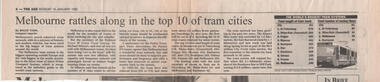
Newspaper, The Age, "Melbourne rattles along in the top 10 of tram cities", 16/1/1995
Newspaper cutting about the position of Melbourne trams in the world in terms of kilometres of track and the number of routes based on Jane's Urban Transport Systems. Has comments from the National Trust, PTUA, and about the tram fleet. Notes the recent growth in the Melbourne system. Item written by Bruce Tobin. How Jane's obtained or intepreted their information is unkinown - a check at the time of cataloguing notes that Prague was 144km and Poznan was about 66km of route - based on their Wikipedia pages. Yields information about Melbourne's position in the world tram list in 1995 - but this is subject to interepretion.Newspaper cutting from The Age 16/1/1995tramways, melbourne, length, routes -
 Eltham District Historical Society Inc
Document - Property Binder, Eltham Mall, 10-18 Arthur Street, Eltham
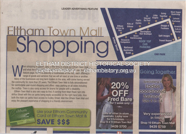
1. Eltham Town Mall Shopping, Diamond Valley Leader, October 26, 2005 [ On reverse - "Red alert for green area by Natalie Birch and Shane Woodrow about a report compiled by Environment Victoria, Melbourne's Threatened Habitats Under Threat: Development Pressures and Conservation Solutions which places the 'Nillumbik Foothills' number seven on list of most endangered by urban sprawl] 2. Advertisement: Huge Bikle Sale, Paul's Cycles, Diamond Valley Leader, February 7, 2007eltham, businesses, eltham town mall, paul's cycles, shops, brushtailed phascogale, click here to add keywords, cr greg johnson, eltham copper butterfly, environment victoria, environmental significance overlay, green wedges coalition, nillumbik shire council, powerful owl, significant landscape overlay, victorian national parks association, aroma's cafe and florist, arthur street, barringtons hair boutique, bowz hairdressing, eltham dress up box, going together, kids of eltham, leisure footwear, little angels, national australia bank, research computers, shoppe 8 fashions, split images, st vincent de paul, travel bound, ward sagar bookshop -
 Robin Boyd Foundation
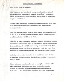
Document - Manuscript, Robin Boyd, New Life For Our Cities, 1965
Boyd asks "What sort of cities do we want?" Various alternatives were discussed at the 14th Royal Institute of Architects convention 1965. The theme of the convention was Civic Development, accompanied by a public exhibition "Man in the Street". A fairly clear definition of the ideal shape for our urban character emerged. It was accepted that congestion, dullness and ugliness would become even more of a problem. Boyd offers a bird's eye view of the nature of our cities as we move progressively outwards.Original manuscript of an article published as ‘New life for Cities. The choice – metropolitan excitement or Canberra order?' in The Australian, 10.4.1965.Typewritten (c copy), quarto, 6 pagesroyal institute of architects convention 1965, australian cities, arthur odell, john overall, robin boyd, manuscript -
Ballarat Tramway Museum
Document - Report, State Electricity Commission of Victoria (SECV), "Creation of a state electricity Commission"
Report titled "Creation of a State Electricity Commission", and "History of Provincial tramways before Act No. 3845 - 1929". Outlines the context of the SEC Act of 1919 which did not include tramway operation by the power or electricity supply authority - was seen as a Municipal concern. Gives the alternatives that were considered, including the agreement with the Municipal Councils of Geelong, Ballarat, and Bendigo. Notes the operation of urban omnibus services and the issues of the lack of municipal supervision, though later on this occurred through the Transport Regulation Board.Yields information about the operation of the Provincial tramways under the control of the SECV.Five foolscap sheets, carbon copycouncils, secv, buses, ballarat, bendigo, geelong, trb -
 Melton City Libraries
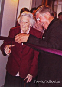
Photograph, Edna Barrie, Unknown
Over 20 years commencing in the 1970s, Edna undertook extensive photographing of the changing streetscape of Melton’s High Street. She anticipated the impact of change on the community during the time of Melton’s rapid transition from a small farming district to a large urban community and this led to her extensively document and photograph many of the structures and landscape features of the township that have since been lost. She also meticulously recorded much of the contemporary life of the town and has left a significant legacy of archival material. Edna Barrie cutting a ribbon to an opening of a eventlocal identities, pioneer families