Showing 1625 items
matching yarra river
-
 Eltham District Historical Society Inc
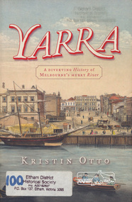
Book, Kristin Otto, Yarra : a diverting history of Melbourne's murky river / Kristin Otto, 2005
... yarra river... the river itself, Yarra is both a fascinating read and a fitting... the river itself, Yarra is both a fascinating read and a fitting ..."It was John Wedge, Batman's private surveyor, who named the Yarra Yarra. In September 1835 he was at the Turning Basin with some Kulin and heard them identify the river as it came over the Falls as, he wrote, 'Yarrow Yarrow'. It was only some months later that Wedge discovered they had been referring to the pattern and movement of water over the Falls, not the river itself. And ever since, it has been the Yarra's fate to be misunderstood: maligned for its muddiness, ill-used as sewer and tip; scooped, sculpted, straightened and stressed, 'cleaned up' to the detriment of its natural inhabitants; built-over, under and beside; worked mercilessly and then bridged almost to maritime extinction. In Kristin Otto's superbly entertaining new history, the whole sorry tale is laid bare. From the creation stories of Kulin owners and geologist blow-ins (and Robert Hoddle's bad-tempered expedition to the headwaters) to the twenty-first-century waterside building boom, Otto traces the course of Melbourne's murky river. Erudite, affectionate and witty, with more meanders and diversions than the river itself, Yarra is both a fascinating read and a fitting tribute to the 'noble stream'." -- Publisher's website.Paperback; [viii], 245 p. : illus., maps ; 24 cm.ISBN 1920885781yarra river -
 Federation University Historical Collection
Book, Beyond Rhetoric: University - Community engagement in Victoria
... on the front cover. Melbourne Arts Centre, Sky view of Yarra River.... Melbourne Arts Centre, Sky view of Yarra River and more. Beyond ...University - Community enagagement partnerships survey analysedRed and black covered book with pictures of buildings on the front cover. Melbourne Arts Centre, Sky view of Yarra River and more.non-fictionUniversity - Community enagagement partnerships survey analysed beyond rhetoric, university community enagagement, alexandra winter, john wiseman, bruce muirhead, anne badenhorst, david birch, catherine burnheim, brian galligan, ann gervasoni, david jones, anne langworthy, john mcdonald, winsome roberts, maureen rogers, keith boast -
 Kew Historical Society Inc
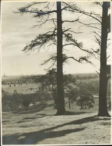
Photograph - Golf course viewed from East Kew, 1940s?
... View of Latrobe Course from the Kew side of the River Yarra... Yarra. River in middle foreground. Aged pine tree central ...Landscape photograph of Kew and Fairfield. Undated but possibly 1930s.View of Latrobe Course from the Kew side of the River Yarra. River in middle foreground. Aged pine tree central foreground. Inscribed reverse: "M Holmes"kew (vic.), latrobe golf course -
 Eltham District Historical Society Inc
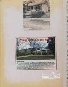
Newsclipping, 24 Antoinette Boulevard, Eltham South and Yarra Braes on the river
... 24 Antoinette Boulevard, Eltham South and Yarra Braes on... Boulevard Yarra Braes Newspaper clippings advertising house auctions ...Contained in Volume 1 of a set of two spiral magnetic photo albums, each containing 10 leaves, 20 pages; Vol. 1 labelled "Houses - Eltham South" and Vol. 2 labelled "Eltham Houses". Newspaper clippings advertising house auctionseltham, eltham south, real estate advertisement, houses, antoinette boulevard, yarra braes -
 Kew Historical Society Inc
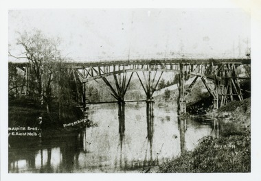
Print, Studley Pk Toll Bridge, July 12 1899
... toll bridges -- river yarra... bridges -- river yarra bridges - yarra river -- kew (vic.) penny ...Black and white print photograph of the wooden 'Penny Bridge' at Studley Park. The name was colloquially arrived at as a penny wa the toll one paid to cross the bridge. The copy of the postcard identifies the photographers as McAlpin Bros, Richmond.Reverse: "Studley Pk Toll Bridge / joining Church Street Abbotsford / Penny Bridge"toll bridges -- river yarra, bridges - yarra river -- kew (vic.), penny bridge -
 Kew Historical Society Inc
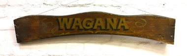
Sign, Wagana, 1920s
... boathouses - river yarra... boats. burns' boatshed thames pulling boats yarra river -- kew ...In the 1920s and 30s, rowing on the Yarra was a very popular weekend pastime. Each of the early boats was individually named in gold letters on its varnished wooden backboard. This is all that remains of one of the Thames pulling boats from Burns' Boatshed at Studley Park which was destroyed by a falling tree in a storm. Their entire fleet of rowing boats has now been replaced by fiberglass boats.Varnished wooden backplate of a rowing boat. The shaped sign is embossed with the name 'Wagana" in gold lettering, outlined and shaded in black paint. Gilt scroll work surrounds the name. The ends of the backplate shows the holes where the plate was once attached to the seat of the boat. The name Wagana means 'to dance' in Wiradjuri language."Wagana"burns' boatshed, thames pulling boats, yarra river -- kew (vic.), boathouses - river yarra -
 Kew Historical Society Inc
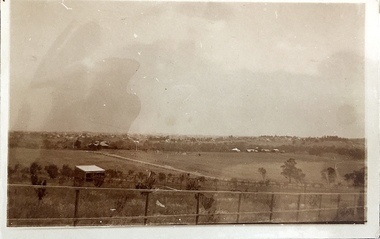
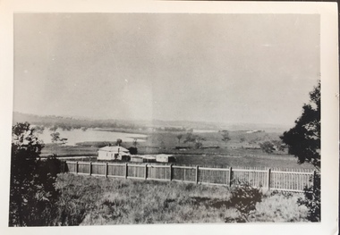
Photograph - Yarra Valley at Kew, 1918
... yarra river... parks. yarra river yarra valley Verso: "Willsmere / East Kew ...During the nineteenth century, the land abutting the south side of the Yarra in Kew was devoted to dairy farming. In the twentieth century, before and after the construction of the Eastern Freeway, much of this low-lying area was used as golf courses and public parks.View of the farmland in the Yarra Valley at what is believed to be East Kew in 1918. Verso: "Willsmere / East Kew? / 1918"yarra river, yarra valley -
 Kew Historical Society Inc
Photograph - Yarra Valley at Kew, 1912
... yarra river... parks. yarra river yarra valley farming -- kew (vic.) Verso ...During the nineteenth century, the land abutting the south side of the Yarra in Kew was devoted to dairy farming. In the twentieth century, before and after the construction of the Eastern Freeway, much of this low-lying area was used as golf courses and public parks.Real-photo postcard of the farmland in the Yarra Valley in what is believed to be North Kew in 1912. Verso: "Willsmere / East Kew / 1912"yarra river, yarra valley, farming -- kew (vic.) -
Port Melbourne Historical & Preservation Society
Photograph - Moreton Bay, outbound in the Yarra, Glen Stuart, 1950s
... in Yarra River... 1950s: Moreton Bay, outbound in Yarra River Photograph Moreton ...One of nine photographs taken of various ships at Port Melbourne and river berths in the early 1950s: Moreton Bay, outbound in Yarra Rivertransport - shipping, moreton bay -
 Federation University Historical Collection
Book - Report, Report of Royal Commission into the Failure of West Gate Bridge, 1971, 1971
... of the Westgate Bridge over the Yarra River. .2) Document relatng... of the Westgate Bridge over the Yarra River. .2) Document relatng ....1) Foolscap soft brown covered report on the failure of the Westgate Bridge over the Yarra River. .2) Document relatng to the collapse of the Westgate Bridgewestgate bridge, bridges, royal commission, c.h. rixon, west gate, engineering -
 Tatura Irrigation & Wartime Camps Museum
Book, The Story of Melbourne, 1934
... discovery scene and Yarra river, Flinders Street, Station and St... and Yarra river, Flinders Street, Station and St. Paul's Cathedral ...Cream, pale green cover. Brown lettering. Sketches of early discovery scene and Yarra river, Flinders Street, Station and St. Paul's Cathedralthe story of melbourne, kenyon af, stewart f, tatura, victorian history, sir gengoult-smith -
Port Melbourne Historical & Preservation Society
Photograph - Queen Street Bridge, Melbourne, 1990s
... , looking towards Queen Street Bridge with the Yarra River... with the Yarra River in foreground and the city skyline in background ...Colour photograph taken from under King Street Bridge, looking towards Queen Street Bridge with the Yarra River in foreground and the city skyline in backgroundbuilt environment, engineering - bridges -
 University of Melbourne, Burnley Campus Archives
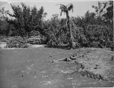
Photograph - Black and white print, A.P. Winzenried, Flood Damage, 1934
... in the Burnley orchards by the 1934 flood of the Yarra River. One large... orchards by the 1934 flood of the Yarra River. One large tree ...Appears as an illustration in, "Green Grows Our Garden," A.P. Winzenried p 66. On p. 66 of the text there is further information about the effects of the flood.Black and white photograph. Destruction caused in the Burnley orchards by the 1934 flood of the Yarra River. One large tree is upside down with its roots in the air.On reverse, "1934."orchard, green grows our garden, a.p. winzenried, flood damage, fruit trees -
 Kew Historical Society Inc
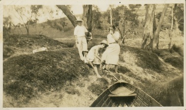
Photograph - Picnic beside the Yarra at Kew, 1938
... River Yarra...Rowing on the River Yarra was a recreational traditional... Rowing on the River Yarra was a recreational traditional pastime ...Rowing on the River Yarra was a recreational traditional pastime for the people of Kew and Melbourne since settlement in the 1830s. Later in the century, boats were frequently hired from boathouses.Three people beside the Yarra. Teenage girl (?) pulling a row boat towards the shore. Photo taken from boat. Sparse riverside vegetation. Reverse: "Jan 38"river yarra, recreation -- rowing -
Port Melbourne Historical & Preservation Society
Plan - Proposed improvements to Hobsons Bay, Melbourne Harbor Trust, The Melbourne Harbor Trust Commissioners - General p`lan shewing proposed harbor improvements 1915, 1915
... into the bay near the river and on the north side of the Yarra River.... the Yarra. The proposals include piers into the bay near the river ...MHT plan of proposed improvements to Hobson's Bay and areas surrounding and bordering the Yarra. The proposals include piers into the bay near the river and on the north side of the Yarra River.melbourne harbor trust - port of melbourne authority, hobson's bay, town planning - proposals shelved -
 Nillumbik Shire Council
Painting: Guy STUART (b.1942 ACT), Guy Stuart, Tunnel by the Yarra, 2004
... An abstract painting of the Yarra River from Pound Bend... of the Yarra River from Pound Bend in Warrandyte. The painting is quite ...An abstract painting of the Yarra River from Pound Bend in Warrandyte. The painting is quite expressive, linear and gestural in style. Muted, neutral tones of greens, browns and reds. -
 Kew Historical Society Inc
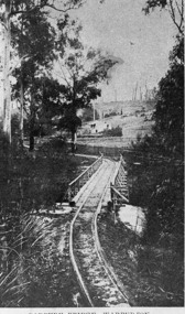
Photograph, Railway Viaduct, c.1900
... Railway viaduct, Yarra River, linking Kew and Fairfield... Mills, Alphington. Railway viaduct, Yarra River, linking Kew ...Railway viaduct, Yarra River, linking Kew and Fairfield. Built by John Monash for the Outer Circle Railway. In 1930 converted into the Chandler Highway Bridge for vehicular traffic. Annotations on reverse: "KH-71. Outer Circle Railway Bridge (over Yarra) looking from Kew side to site of Paper Mills, Alphington.outer circle railway, railway viaduct (kew), john monash, chandler highway bridge -
 Kew Historical Society Inc
Photograph - Yarra in Flood - Belford & Kilby Farms, 1903
... of the Yarra River. This photo is a copy of the original photo... of the Yarra River. This photo is a copy of the original photo ...The Yarra Valley in what was previously called North Kew, but is now East Kew, was frequently subjected to flooding. Apart from some development on higher ground, the City of Kew regularly introduced restrictions on development and the building of housing in the area because of flood levels. Panoramic photographic positive of North Kew where the Belford and Kilby Farms were located on the south side of the Yarra River. This photo is a copy of the original photo in the collection.floods -- yarra -- 1903, kew golf course, greenacres golf course -
 Upper Yarra Museum
Negative Photographic Reproduction, Parbury Bridge Warburton, 14.2.1983
... parbury bridge warburton tramway yarra river... bridge warburton tramway yarra river Parbury Bridge Warburton ...Parbury Bridge Warburton Negative Black white. Scanned at 600 dpi.parbury bridge warburton tramway yarra river -
 Upper Yarra Museum
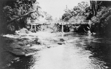
Negative Photographic Reproduction, Bridge over the Yarra
... bridge over yarra river... over yarra river 03050 Bridge over the Yarra. Upper Yarra Shire ...03050 Bridge over the Yarra. Upper Yarra Shire 1888-1988 Centenary collection. Black & white Negative, scanned at 600 dpibridge over yarra river -
 Eltham District Historical Society Inc
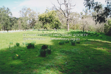
Photograph, Fay Bridge, Griffith Park, Eltham, n.d
... Yarra River... Yarra River 3 images - Scanned from colour prints on loan ...Griffith Park is the former property and home of Cr Fred Griffith in the 1950sfay bridge collection, daffodils, griffith park, yarra river -
 Eltham District Historical Society Inc
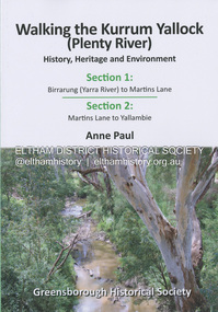
Book, Anne Paul, Walking the Kurrum Yallock (Plenty River), 25 July 2023
... Yarra River... Yarra River Paperback; 74 pages; 17 x 0.5 x 24.4 cm Walking ...Kurrum Yallock - the Plenty River is Melbourne's third river. It is a defining feature of the region weaving its way through local suburbs and parklands. It is often hidden from general view, emerging at bridges and along its extensive trail network. While diminished since European settlement, the River provides an important environmental, wildlife corridor and recreational resource, along with many links to its settlement heritage. The Kurrum Yallock walks aim to guide people along the River Trail, while providing insight into key aspects of our recent history, an opportunity for reflection and an enhanced enjoyment of the River's special environment and landscape.birrarung, greensborough historical society, kurrum yallock, martins lane, plenty river, yallambie, yarra river -
 Eltham District Historical Society Inc
Photograph - Aerial Photograph, Landata, Eltham, Feb. 1956
... Yarra River... Orchard Reynolds Road Sweeneys Lane Templestowe Yarra River ...Centred on present day Culla Hill and Petty's Orchard, Eltham bounded by Brougham Street and Mount Pleasant Road to north, Monckton Road, Templestowe to south, Reynolds Road to east and Eltham Lower Park and Hohnes Road to west. Historic Aerial Imagery Source: Landata.vic.gov.au Aerial Photo Details: Project No :250 Project : MELBOURNE OUTER SUBURBS PROJECT Run : 18 Frame : 92 Date : 02/1956 Film Type : B/W Camera : EAG9 Flying Height : 10000 Scale : 12000 Film Number : 1176 GDA2020 : 37°43'35"S, 145°09'31"E MGA2020 : 337735, 5822959 (55) Melways : 22 B8 (ed. 42)aerial photo, 1956-02, neil webster collection, eltham, brougham steet, culla hill, eltham lower park, hohnes road, melway 22b8, monckton road, mount pleasant road, petty's orchard, reynolds road, sweeneys lane, templestowe, yarra river -
 Eltham District Historical Society Inc
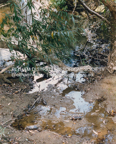
Photograph (Item) - Print, Craig Price, Trees, Water And Beer Bottles - River Bank Eltham, 1988
... Yarra River... Series 35 Craig Price Yarra River Front: Entrant No. and name ...Craig Price 1988 Entrant No. 148 Ref: Series 34, Items 37, 38, 109, 110 No negative (or missing) SHIRE OF ELTHAM COMMUNITY PHOTOGRAPHIC SURVEY Photography is an artform which many of us practice, sometimes purely for artistic pursuit, sometimes to record the people and events in our lives. In 1988, as part of a local Bicentennial project, the Shire of Eltham conducted the Eltham Community Photographic Survey. Up to 100 entries were to be selected by a panel of photographers for entry into the Eltham Photographic Survey Exhibition. Entries had to be submitted by May 13, 1988. Entrants whose images were selected for the exhibition were contacted and requested to further submit an entry form providing entrant’s name, area of residence, age, and proposed captions. These details were then used to produce labels for the exhibition mounts. Where negatives had not been supplied, these were requested to support the display of printed enlargements mounted on 10” x 8” cardboard. The mounted prints were made available post exhibition for sale at $8.50 each for colour prints and $7.00 for B&W prints. Residents in the Shire were invited to collect a free roll of film and take a photograph of what they either liked or did not like about the area. A total of 160 entrants submitted multiple entries for the exhibition. Of those selected for exhibition, entrants ranged in age from 9 to 70 years. All custom colour and black and white printing for the exhibition was completed by Wattle Studios of Eltham. The Eltham Photographic Survey was jointly auspiced by the Shire of Eltham and Wattle Studios, of 953 Main Road, Eltham. The project was greatly assisted by: • David McRitchie, Media Studies Lecturer Victoria College, Rusden Campus. • Ian and Annette Toohill of Wattle Studios • Tracy Naughton, Eltham Community Arts Officer • Neville Emerson Pty. Ltd. • Superior Press, Eltham • Kodak Australasia Pty. Ltd. • Agfa Gevaert Ltd. • Townsend Colourtech Pty. Ltd. • The Australian Bicentennial Authority • Eleanor Bowers, Secretary, Eltham Arts Council The exhibition was placed on display in the Woolworths Arcade, Eltham between Monday June 6th and Saturday June 11, 1988. It was also intended to hold the exhibition at a venue in the Shire’s North Riding from Monday, June 20 to Friday June 24. It was then displayed at the Were Street Theatre, Montmorency from Friday, June 24 to Thursday, July 7. Series 34: Eltham Community Photographic Survey 1988 - Prints & Documentation Series consists of 117 photographs of Shire scenes taken by members of the community. Items I - 41 are larger photographs mounted on card, which were exhibited. Items 42 - 117 are unmounted copies, alternative takes and other entries. Corresponding negatives contained in Series 35: Eltham Community Photographic Survey 1988 – Negatives which consists of 267 colour and B&W negatives and one colour slide of Shire scenes taken by members of the community. The negatives are arranged by the entrant number of the photographer. The Eltham Community Photographic Survey collection is significant to the local community as it was curated by the local community - ordinary people of all ages - representing what they liked and did not like in the area where they lived. It represents an unfiltered representation of the Shire of Eltham as it was in 1988. It also represents one of many projects as part of the national programme of events and celebrations to commemorate the bicentenary. It is a time capsule of life in the 1980s of this urban and rural municipality in Melbourne's north. Front: Entrant No. and name on printed label Rear: Entrant No., name and address on printed label; also 'Series 34' and the 'Item No.' in pencilshire of eltham archives, bicentennial project, eltham, eltham community photographic survey, eltham photographic survey exhibition, series 34, series 35, craig price, yarra river -
 Eltham District Historical Society Inc
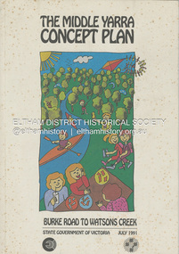
Book, State Government of Victoria, The Middle Yarra Concept Plan: Burke Road to Watsons Creek, July 1991
... Yarra River... melbourne recreation areas regional planning Yarra River Watsons ...A draft concept plan developed for the Middle Yarra River between Burke Road and Watsons Creek which includes planning controls, developed and managed to meet the recreation and landscape objectives whilst protecting the natural resourcesa nd cultural heritage. It established a broad framework for more detailed plans and guidelines. Jointly produced by staff from the Victorian Department of Planning and Housing. July 1991.non-fictionA draft concept plan developed for the Middle Yarra River between Burke Road and Watsons Creek which includes planning controls, developed and managed to meet the recreation and landscape objectives whilst protecting the natural resourcesa nd cultural heritage. It established a broad framework for more detailed plans and guidelines. Jointly produced by staff from the Victorian Department of Planning and Housing. July 1991.recreation areas, regional planning, yarra river, watsons creek -
 Eltham District Historical Society Inc
Document - Folder, McLean, 1984-1999
... Yarra River... Warrandyte Bridge Warrandyte Wingrove park Yarra River EDHS_04789 ...References to McLean family, Hector John McLean and Louisa Frances (nee Green) and six daughters who lived in Eltham during the period 1930 to 1934 inclusive. Lived in the former Evelyn Hotel at the time it was destroyed by fire and being part of the Centenary Parade in 1934 where the family won the Group Section for their entry “Pioneers of Eltham” Reminiscences provided by Edith Jones (nee M1934 flood, ballroom, baptism, barber shop, bittern, boy scouts, bremner's flat, burgoyne's shop, cable tram, cemetery road, centenary celebrations, centenary parade, christening, coach house, collis grocery, dalton street, depression, dole, dorothy jean mclean, edith jones (nee mclean), eltham fire brigade, eltham high school, eltham higher elementary school, eltham lower park, eltham railway station, eltham state school no. 209, evelyn hotel, fire damage - buildings, flinders naval depot, fordham, gladys evelyn mclean, gold mining, gwenneth mae mclean, gwladys evelyn mclean, headmistress, hector john mclean, isherwood house and shop, louisa frances mclean (nee green), metery road, methodist church, miss finnin, miss grant cottage, motor bike races, mrs barrett, mrs bremner, mrs hurley, olive isabel mclean, parade, phoebe lillian mclean, picnic, pioneers of eltham, pitt street, research fire brigade, rev. r.g. arthur, shed, shops, st margarets church hall, st margaret's church, stables, state savings bank of victoria, susso books, todaro, vinnie willet, warrandyte bridge, warrandyte, wingrove park, yarra river -
 Eltham District Historical Society Inc
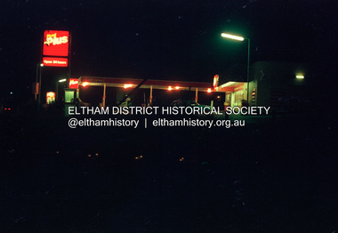
Photograph (Item) - Negative, Mathew Wakefield, Eltham Community Photographic Survey Entry, 1988
... Yarra River... Trail Yarra River Beard Street Food Plus Service Station Colour ...Mathew Wakefield 1988 Entrant No. 40 Ref: Series 34, Items 87, 88 The images in this record were not selected for inclusion. SHIRE OF ELTHAM COMMUNITY PHOTOGRAPHIC SURVEY Photography is an artform which many of us practice, sometimes purely for artistic pursuit, sometimes to record the people and events in our lives. In 1988, as part of a local Bicentennial project, the Shire of Eltham conducted the Eltham Community Photographic Survey. Up to 100 entries were to be selected by a panel of photographers for entry into the Eltham Photographic Survey Exhibition. Entries had to be submitted by May 13, 1988. Entrants whose images were selected for the exhibition were contacted and requested to further submit an entry form providing entrant’s name, area of residence, age, and proposed captions. These details were then used to produce labels for the exhibition mounts. Where negatives had not been supplied, these were requested to support the display of printed enlargements mounted on 10” x 8” cardboard. The mounted prints were made available post exhibition for sale at $8.50 each for colour prints and $7.00 for B&W prints. Residents in the Shire were invited to collect a free roll of film and take a photograph of what they either liked or did not like about the area. A total of 160 entrants submitted multiple entries for the exhibition. Of those selected for exhibition, entrants ranged in age from 9 to 70 years. All custom colour and black and white printing for the exhibition was completed by Wattle Studios of Eltham. The Eltham Photographic Survey was jointly auspiced by the Shire of Eltham and Wattle Studios, of 953 Main Road, Eltham. The project was greatly assisted by: • David McRitchie, Media Studies Lecturer Victoria College, Rusden Campus. • Ian and Annette Toohill of Wattle Studios • Tracy Naughton, Eltham Community Arts Officer • Neville Emerson Pty. Ltd. • Superior Press, Eltham • Kodak Australasia Pty. Ltd. • Agfa Gevaert Ltd. • Townsend Colourtech Pty. Ltd. • The Australian Bicentennial Authority • Eleanor Bowers, Secretary, Eltham Arts Council The exhibition was placed on display in the Woolworths Arcade, Eltham between Monday June 6th and Saturday June 11, 1988. It was also intended to hold the exhibition at a venue in the Shire’s North Riding from Monday, June 20 to Friday June 24. It was then displayed at the Were Street Theatre, Montmorency from Friday, June 24 to Thursday, July 7. Series 34: Eltham Community Photographic Survey 1988 - Prints & Documentation Series consists of 117 photographs of Shire scenes taken by members of the community. Items I - 41 are larger photographs mounted on card, which were exhibited. Items 42 - 117 are unmounted copies, alternative takes and other entries. Corresponding negatives contained in Series 35: Eltham Community Photographic Survey 1988 – Negatives which consists of 267 colour and B&W negatives and one colour slide of Shire scenes taken by members of the community. The negatives are arranged by the entrant number of the photographer. The Eltham Community Photographic Survey collection is significant to the local community as it was curated by the local community - ordinary people of all ages - representing what they liked and did not like in the area where they lived. It represents an unfiltered representation of the Shire of Eltham as it was in 1988. It also represents one of many projects as part of the national programme of events and celebrations to commemorate the bicentenary. It is a time capsule of life in the 1980s of this urban and rural municipality in Melbourne's north. shire of eltham archives, bicentennial project, eltham community photographic survey, dalton street, eltham, film - fuji 100, main road, mathew wakefield, scan - 35mm negative, series 35, wiingrove park trail, yarra river, beard street, food plus service station -
 Eltham District Historical Society Inc
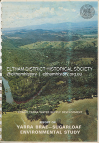
Book, Melbourne Metropolitan Board of Works, Lower Yarra Water Supply DeVelopment: Report on Yarra Brae-Sugarloaf Environmental Study, April 1974
... Yarra River Valley... Yarra Brae Dam Yarra River Valley A4 x 3cm Spiral bound 1 v ...environmental study, melbourne metropolitan board of works, report, sugarloaf reservoir, water catchment area, water supply, yarra brae dam, yarra river valley -
 Eltham District Historical Society Inc
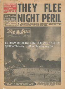
Newspaper - Newspaper articles, Sun News-Pictorial, They Flee Night Peril, The Sun News-Pictorial, Wednesday, January 17, p1, 1962
... Yarra River... Hills Yarra River Mitcham Whitehorse Roiad Donvale Park Orchards ...Various news articles pertaining to the January 1962 Victorian bushfires in the Dandenong and Healesville districts which by the third day had encompassed large areas of the State. Specific Eltham Shire districts mentioned include Panton Hill and Hurstbridge on page 1, Warrandyte on page 2, 3, 4 and 5, Hurstbridge, Smith’s Gully, Kinglake on page 3 and 4, Strathewen, Kangaroo Ground, Panton Hill, St. Andrews, Smith’s Gully on page 4 and Pound Bend, Smith’s Gully and Warrandyte on pages 20-21 • They Flee Night Peril, p1 (Illust.) • Their grim picnic; A flash fire strikes, p2 (Illust.) • Night of terror as towns quitted, p3 • Fought till he dropped, p3 (Illust.) • Rain in fire area, p3 • Wye River town goes, p3 • Black Friday Hero Dies In Fire; with wife, grandsons, p4 • Surrounded!, p4 (Illust.) • Main street houses ablaze, p4 • Hurstbridge is evacuated, p4 • Scores jump in river at Warrandyte, p5 • Hills people leave homes, p5 • “Fire” cry at Parlt., p5 • Blind – he’s safe now, p5 (Illust.) • Police Chief Runs Battle, p7 • From Fire Front: Hospital treats 34, p7 • Firms send help, p7 • Tragedy and Ruin: Third Day; Ferntree Gully; Warrandyte; Pound Bend; Smiths Gully; Escape for 18, pp20-21 (Illust.) • Church was a haven for the hurt, weary, p39 (Illust.) • A home is lost, p40 (Illust.) tom fielding collection, victorian bushfires - 1962, victorian bushfires – 1962, panton hill, hurstbridge, five ways crossroads, warrandyte south, dandenongs, upwey, mt. evelyn, monbulk, olinda, sassafras, st. andrews, warrandyte, christmas hills, yarra river, mitcham, whitehorse roiad, donvale, park orchards, metropolitan fire chief, w.t. aldridge, loughnan’s hill, ringwood, woori yallock, leslie ockwell, linda ockwell, kalorama, healesville, daylesford, fire damage – buildings, wye river, portland, eganstown, ballarat, sherbrooke park forest, forest commission headquarters, kallista, r.t. seaton, montrose, yallourn, central gippsland, smith’s creek, black friday, geoffrey ockwell, ronald ockwell, preston town hall, e.j. tenner, strathewen, kangaroo ground, eric farnsworth, adele farnsworth, robin farnsworth, roy cleland, ann cleland, belgrave, sassfras, kaloramalice commissioner porter, mansfield, box hill hospital, pound bend, ferntree gully, ferntree gully state school, w. carew, ann quinton -
 Eltham District Historical Society Inc
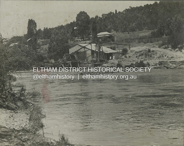
Photograph - Black and White Print, J.E. Barnes, The old water wheel, Warrandyte, c.1920
... Yarra River... Yarra River Black & White / Sepia print mounted on card The old ...Josiah Earl BARNES (Australian, 1858–1921) was a noted WW1 photographer who took many photographs of departing troopships and men. The Australian War Memorial holds around 1,436 negatives and prints by J.E. Barnes. His daughter, D. Barnes (married name Smyth) was also a photographer and lived in Diamond Creek from around 1910 to circa 1940.david smyth collection, warrandyte, warrandyte battery, yarra river