Showing 2589 items matching "aerial"
-
 Glenelg Shire Council Cultural Collection
Photograph - Photograph - Aerial Photo railway line between Heywood and Rennick, 03/05/1952
Victorian Railways aerial survey record print of the railway line between Heywood and Rennick (S.A. border) Black and white, white vertical strip on imageBack: 'Heywood - Rennick 21074 - 19365 235m 55c Heywood' - all black ink. Purple VR aerial survey stamp. '3 May 1952' - black stamp -
Glenelg Shire Council Cultural Collection
Photograph - Photograph - Aerial Photo railway line between Heywood and Rennick, 03/05/1952
Victorian Railways aerial survey record print of the railway line between Heywood and Rennick (S.A. border) Black and white, white vertical strip on imageBack: 'Heywood - Rennick 21223 - 19504 248m 23c Heywood' - all black ink. Purple VR aerial survey stamp. '3 May 1952' - black stamp -
Glenelg Shire Council Cultural Collection
Photograph - Photograph - Aerial Photo railway line between Heywood and Rennick, 03/05/1952
Victorian Railways aerial survey record print of the railway line between Heywood and Rennick (S.A. border) Black and white, white vertical strip on imageBack: 'Heywood - Rennick 21087 - 19378 236m 18c Heywood' - all black ink. Purple VR aerial survey stamp. '3 May 1952' - black stamp -
Glenelg Shire Council Cultural Collection
Photograph - Photograph - Aerial Photo railway line between Heywood and Rennick, 03/05/1952
Victorian Railways aerial survey record print of the railway line between Heywood and Rennick (S.A. border) Black and white, white vertical strip on imageBack: 'Heywood - Rennick 21083 - 19374 235m 78c Heywood' - all black ink. Purple VR aerial survey stamp. '3 May 1952' - black stamp -
Glenelg Shire Council Cultural Collection
Photograph - Photograph - Aerial Photo railway line between Heywood and Rennick, 03/05/1952
Victorian Railways aerial survey record print of the railway line between Heywood and Rennick (S.A. border) Black and white, white vertical strip on imageBack: 'Heywood - Rennick 21388 - 19659 260m 75c Heywood' - all black ink. Purple VR aerial survey stamp. '3 May 1952' - black stamp -
Glenelg Shire Council Cultural Collection
Photograph - Photograph - Aerial Photo railway line between Heywood and Rennick, 03/05/1952
Victorian Railways aerial survey record print of the railway line between Heywood and Rennick (S.A. border) Black and white, white vertical strip on imageBack: 'Heywood - Rennick 21073 - 19364 235m 50c Heywood' - all black ink. Purple VR aerial survey stamp. '3 May 1952' - black stamp -
Glenelg Shire Council Cultural Collection
Photograph - Photograph - Aerial Photo railway line between Heywood and Rennick, 03/05/1952
Victorian Railways aerial survey record print of the railway line between Heywood and Rennick (S.A. border) Black and white, white vertical strip on imageBack: 'Heywood - Rennick 21390 - 19661 261m 12c Dartmoor'' - all black ink. Purple VR aerial survey stamp. '3 May 1952' - black stamp -
Glenelg Shire Council Cultural Collection
Photograph - Photograph - Aerial Photo railway line between Heywood and Rennick, 03/05/1952
Victorian Railways aerial survey record print of the railway line between Heywood and Rennick (S.A. border) Black and white, white vertical strip on imageBack: 'Heywood - Rennick 21076 - 19367 235m 63c Heywood' - all black ink. Purple VR aerial survey stamp. '3 May 1952' - black stamp -
Glenelg Shire Council Cultural Collection
Photograph - Photograph - Aerial Photo railway line between Heywood and Rennick, 03/05/1952
Victorian Railways aerial survey record print of the railway line between Heywood and Rennick (S.A. border) Black and white, white vertical strip on imageBack: 'Heywood - Rennick 21086 - 19386 235m 31c Heywood' - all black ink. Purple VR aerial survey stamp. '3 May 1952' - black stamp -
Glenelg Shire Council Cultural Collection
Photograph - Photograph - Aerial Photo railway line between Heywood and Rennick, 03/05/1952
Victorian Railways aerial survey record print of the railway line between Heywood and Rennick (S.A. border) Black and white, white vertical strip on imageBack: 'Heywood - Rennick 21224 - 19505 248m 31c Heywood' - all black ink. Purple VR aerial survey stamp. '3 May 1952' - black stamp -
Glenelg Shire Council Cultural Collection
Photograph - Photograph - Aerial Photo railway line between Heywood and Rennick, 03/05/1952
Victorian Railways aerial survey record print of the railway line between Heywood and Rennick (S.A. border) Black and white, white vertical strip on imageBack: 'Heywood - Rennick 21150 - 19431 241m 7c Heywood' - all black ink. Purple VR aerial survey stamp. '3 May 1952' - black stamp -
Glenelg Shire Council Cultural Collection
Photograph - Photograph - Aerial Photo railway line between Heywood and Rennick, 03/05/1952
Victorian Railways aerial survey record print of the railway line between Heywood and Rennick (S.A. border) Black and white, white vertical strip on imageBack: 'Heywood - Rennick 21290 - 19562 253m 66c Heywood' - all black ink. Purple VR aerial survey stamp. '3 May 1952' - black stamp -
Glenelg Shire Council Cultural Collection
Photograph - Photograph - Aerial Photo railway line between Heywood and Rennick, 03/05/1952
Victorian Railways aerial survey record print of the railway line between Heywood and Rennick (S.A. border) Black and white, white vertical strip on imageBack: 'Heywood - Rennick 21383 - 19654 260m 39c Heywood' - all black ink. Purple VR aerial survey stamp. '3 May 1952' - black stamp -
Glenelg Shire Council Cultural Collection
Photograph - Photograph - Aerial Photo railway line between Heywood and Rennick, 03/05/1952
Victorian Railways aerial survey record print of the railway line between Heywood and Rennick (S.A. border) Black and white, white vertical strip on imageBack: 'Heywood - Rennick 21355 - 19626 257m 77c Heywood' - all black ink. Purple VR aerial survey stamp. '3 May 1952' - black stamp -
Glenelg Shire Council Cultural Collection
Photograph - Photograph - Aerial Photo railway line between Heywood and Rennick, 03/05/1952
Victorian Railways aerial survey record print of the railway line between Heywood and Rennick (S.A. border) Black and white, white vertical strip on imageBack: 'Heywood - Rennick 21384 - 19655 260m 46c Heywood' - all black ink. Purple VR aerial survey stamp. '3 May 1952' - black stamp -
Glenelg Shire Council Cultural Collection
Photograph - Aerial Survey Railway Record Print – 1952, 03/05/1952
Victorian Railways aerial survey record print of the railway line between Heywood and Rennick (S.A. border) Black and white, white vertical strip on image.Back: 'Heywood - Rennick 21386 - 19657 260m 61c Heywood' - all black ink. Purple VR aerial survey stamp. '3 May 1952' - black stamp -
Glenelg Shire Council Cultural Collection
Photograph - Aerial Survey Railway Record Print – 1952, 03/05/1952
Victorian Railways aerial survey record print of the railway line between Heywood and Rennick (S.A. border) Black and white, white vertical strip on image.Back: 'Heywood - Rennick 21080 - 19371 235m 75c Heywood' - all black ink. Purple VR aerial survey stamp. '3 May 1952' - black stamp -
Glenelg Shire Council Cultural Collection
Photograph - Aerial Survey Railway Record Print - 1952, 03/05/1952
These photos were found in a car that was left for recycling.Victorian Railways aerial survey record print of the railway line between Heywood and Rennick (S.A. border) Black and white, white vertical strip on image.Back: 'Heywood - Rennick 21293 - 19565 254m 10c Greenwald'- all black ink. Purple VR aerial survey stamp. '3 May 1952' - black stampvictorian railways -
Glenelg Shire Council Cultural Collection
Photograph - Aerial Survey Railway Record Print – 1952, 03/05/1952
Victorian Railways aerial survey record print of the railway line between Heywood and Rennick (S.A. border) Black and white, white vertical strip on image.Back: 'Heywood - Rennick 21071 - 19362 235m 39c Heywood' - all black ink. Purple VR aerial survey stamp. '3 May 1952' - black stamp -
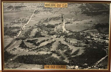 Heidelberg Golf Club
Photograph - Framed Photograph, Heidelberg Golf Club: The old course, 1966c
An aerial photograph of the Heidelberg Golf Course, around 1966 (this date is taken from the road work to build the new bridge over the Plenty River). Known as the 'old course' it was designed by Harry Alexander and was in play until a redesign of the course in 1968. The clubhouse is in top centre of photograph.One of several aerial photogrphs showing the layout of the Heidelberg Golf CourseLarge Black and white aerial photograph, timber frame. Brass plaque top and bottom."Heidelberg Golf Club" "The old course"heidelberg golf club, old course -
Glenelg Shire Council Cultural Collection
Photograph - Photograph - Aerial Photo railway line between Heywood and Rennick, 03/05/1952
Victorian Railways aerial survey record print of the railway line between Heywood and Rennick (S.A. border) Black and white, white vertical strip on imageBack: 'Heywood - Rennick 21452 - 19723 267 m 11 c ' - all black ink. Purple VR aerial survey stamp. '3 May 1952' - black stamp -
Glenelg Shire Council Cultural Collection
Photograph - Photograph - Aerial Photo railway line between Heywood and Rennick, 03/05/1952
Victorian Railways aerial survey record print of the railway line between Heywood and Rennick (S.A. border) Black and white, white vertical strip on imageBack: 'Heywood - Rennick 21291 - 19563 253m 74c Heywood Greenwald ' - all black ink. Purple VR aerial survey stamp. '3 May 1952' - black stamp -
Glenelg Shire Council Cultural Collection
Photograph - Aerial Survey Railway Record Print – 1952, 03/05/1952
Victorian Railways aerial survey record print of the railway line between Heywood and Rennick (S.A. border) Black and white, white vertical strip on image.Back: 'Heywood - Rennick 21221 - 19502 248m 8c Heywood Lyons' - all black ink. Purple VR aerial survey stamp. '3 May 1952' - black stamp -
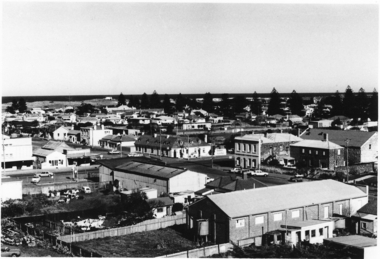
 Orbost & District Historical Society
black and white photograph, February 1971
This photograph is an aerial view of the township of Orbost taken by the Bairnsdale Advertiser newspaper. It was taken from the northern end of the town. The 1971 flood was the the worst flood on record. At Jarrahmond it was at least 11 metres and up to one and a half kilometres wide on the flats causing enormous damage to the flood plain. Records say that "The brown floodwater stain in Bass Strait could be seen from passing airliners." Considerable damage was done to railway infrastructure, roads and farms. More information from the APRIL, 2008 newsletter by John Phillips. (see orbosthistory.com.au)This is a pictorial record of a significant event in the history of Orbost,A black / white aerial photograph of a township with floodwaters in the background.on back - "Note main current through the lagoon 1971."orbost-floods-1971 bairnsdale-advertiser orbost-township -
Whitehorse Historical Society Inc.
Map, Dandenong Ranges Area, 1956
Sheet 1. Parts of Parishes: Nunawading, Warrandyte and Ringwood. Scale: 10 chains : 1 inch. Contour intervals marked and locations of buildings.Sheet 1. Parts of Parishes: Nunawading, Warrandyte and Ringwood. Scale: 10 chains : 1 inch. Contour intervals marked and locations of buildings. Compiled from aerial photographs and cadastral survey information.Sheet 1. Parts of Parishes: Nunawading, Warrandyte and Ringwood. Scale: 10 chains : 1 inch. Contour intervals marked and locations of buildings. maps, ringwood, mitcham, warrandyte -
Glenelg Shire Council Cultural Collection
Photograph - Photograph - Aerial Photo railway line between Heywood and Rennick, 03/05/1952
Victorian Railways aerial survey record print of the railway line between Heywood and Rennick (S.A. border) Black and white, white vertical strip on imageBack: 'Heywood - Rennick 21581 - 19844 279m 70c 62 SA border ' - all black ink. Purple VR aerial survey stamp. '3 May 1952' - black stamp -
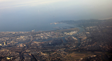 Ballarat Heritage Services
Photograph, L.J. Gervasoni, Mouth of the Yarra River from the air, 2016
Digital Image showing an aerial view of the mouth of the Yarra River from the airaerial, melbourne, mouth, yarra, river, port phillip bay, flemington, docklands, bolte bridge, west gate bridge -
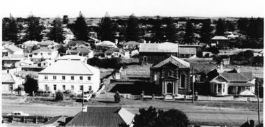
 Port Fairy Historical Society Museum and Archives
Photograph
SE view from St Johns Tower 1973Black and white photograph of aerial view Caledonian & Victoria Hotels centre. Reardon theatre far leftst john's tower, tower, st johns, town, aerial, caledonian, victoria, hotel -
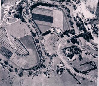 Hume City Civic Collection
Photograph
The aerial photograph shows the market garden situated on the river bend and flat of the Deep Creek at Bulla. In the 19th Century a hotel occupied the site. After World War II the property was owned by the Hughes family, who grew flowers. In 1971 Andrew Vlass purchased the property and it became a market garden until the Vlass family sold it in 1990.A black and white aerial photograph of the river bend and river flat of the Deep Creek at Bulla.scale - 170 feet = 1 inchdeep creek, market gardens, sunbury road, bulla, horticulture, hughes family, vlass, andrew, hotels, george evans collection -
 Port Fairy Historical Society Museum and Archives
Photograph
Views from St Johns 1973Black and white photograph aerial view of Braim House Methodist Church and it's Manse with Sunday school in backgroundphoto, st johns, tower, james street, aerial, methodist, weslyian, braim house