Showing 733 items matching "aerial photo"
-
 Bendigo Military Museum
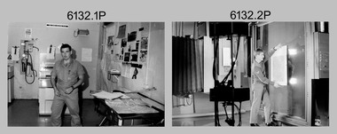
Photograph - Photographic Technicians performing tasks at the Army Survey Regiment, c1970s
These eleven photographs were most likely taken in the 1970s in Lithographic Squadron at the Army Survey Regiment, Fortuna, Bendigo. Although Photo .1P is not annotated the remainder have the technician’s name written on the back. The equipment operated by the technicians is not identified. The dates are unknown but most of these photos were probably taken the late 1970s. The main tasks undertaken by the technicians were most likely enlargements, reductions and duplication of map reproduction material, and aerial photography.This is a set of photographs of technicians operating photographic reproduction equipment at the Army Survey Regiment, Bendigo c1970s. The photographs were printed on photographic paper and are part of the Army Survey Regiment’s Collection. The photographs were scanned at 300 dpi. .1) - Photo, black & white, c1970s, unidentified, Lithographic Squadron .2) - Photo, black & white, c1970s, Gary Drummond, Lithographic Squadron .3) - Photo, black & white, c1970s, John Scott, Lithographic Squadron .4) - Photo, black & white, c1970s, WILD U4A Diapositive Camera, Bob Chamberlain, Lithographic Squadron. 5) - Photo, black & white, c1970s, WILD U4A Diapositive Camera, Zoe (Lisiewich) Ames, Lithographic Squadron .6) - Photo, black & white, c1970s, Garry Hudson, Lithographic Squadron .7) - Photo, black & white, c1970s, Garry Hudson, Lithographic Squadron .8) - Photo, black & white, c1970s, Garry Hudson, Lithographic Squadron .9) - Photo, black & white, c1970s, Mick Ellis, Lithographic Squadron .10) - Photo, black & white, c1970s, Col Darch, Lithographic Squadron .11) - Photo, black & white, c1970s, Phil Beatty, Lithographic Squadron.1P – no annotation .2 to .11 – personnel names (less rank) annotated on back. royal australian survey corps, rasvy, army survey regiment, army svy regt, fortuna, asr, litho -
 Bendigo Military Museum
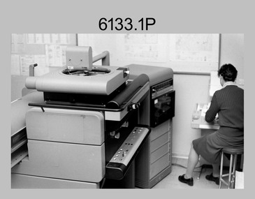
Photograph - Photo Troop, Lithographic Squadron – Army Survey Regiment, Fortuna, Bendigo, 1988
This collection of 10 photos was most likely taken at Lithographic Squadron, Army Survey Regiment, Fortuna, Bendigo in 1988. The main tasks undertaken by technicians in Photo Troop were most likely enlargements, reductions and duplication of map reproduction material, and processing of aerial photography.This is a set of 10 photographs of Photo Troop personnel and equipment from Lithographic Squadron at the Army Survey Regiment, Fortuna, Bendigo, 1988. The photographs were on 35mm negative film and were scanned at 96 dpi. They are part of the Army Survey Regiment’s Collection. .1) - Photo, black & white, 1988, BARCRO work area, SPR Gary Sievers. .2) - Photo, black & white, 1988, KLIMSCH Commodore camera, CPL Mick Gillham. .3) - Photo, black & white, 1988, KLIMSCH Commodore camera, CPL Mick Gillham. .4) - Photo, black & white, 1988, WILD U4A Diapositive Camera, SPR Rob Jones. .5) - Photo, black & white, 1988, WILD U4A Diapositive Camera, SPR Rob Jones. .6) - Photo, black & white, 1988, WILD U4A Diapositive Camera, SPR Rob Jones. .7) - Photo, black & white, 1988, WILD U4A Diapositive Camera, SPR Rob Jones. .8) - Photo, black & white, 1988, WILD U4A Diapositive Camera, SPR Rob Jones. .9) - Photo, black & white, 1988, Photographic camera enlarger, unidentified technician. .10) - Photo, black & white, 1988, SUPER CHROMEGA F Photographic camera enlarger. No personnel are identifiedroyal australian survey corps, rasvy, army survey regiment, army svy regt, fortuna, asr, litho -
 Bendigo Military Museum
Photograph - Orthophotomap Workstation, Lithographic Squadron – Army Survey Regiment, Fortuna, Bendigo, 1988
This collection of four photos was most likely taken at Lithographic Squadron, Army Survey Regiment, Fortuna, Bendigo in 1988. Orthophoto mapping provided the Survey Corps with the capability to produce map products quickly in the event of a crisis. These are four photographs of equipment used by the Army Survey Regiment to produce orthophotomaps. The OR1 orthophoto projector and workstation was introduced in the mid-1980s. It was the second-generation equipment used to orthorectify colour and monochrome film aerial photography, replacing the system introduced in 1973. Orthorectification is the process of removing geometric distortions and scale errors/variations from images. Images have tilt and relief distortions that make it difficult to compare accurately a map and an image of the same geographic area. Once an image is orthorectified, features on the image are shown in their planimetric locations. These four photographs of orthorectification equipment in operation were taken at the Army Survey Regiment at Fortuna, Bendigo, 1988. The photographs were on 35mm negative film and were scanned at 96 dpi. They are part of the Army Survey Regiment’s Collection. .1) to .4) - Photo, black & white, 1988, WILD OR-1 Orthorectification Workstation, SPR Carmel (Butler) Fauth.No personnel are identifiedroyal australian survey corps, rasvy, army survey regiment, army svy regt, fortuna, asr, litho -
 Lara RSL Sub Branch
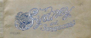
Booklet, Sydney and Surroundings Win and Co Sydney, circa 1945
Photos from 1945 era include Sydney Harbour Bridge, Aerial View looking South East McMahon's Point, Aerial view of Sydney Harbour Bridge looking South West from over Neutral Bay. Top portion of the Bulli Pass. An Entrancing View of the South Coast, from Sublime Point. Government House, Sydney. Central Square Railway Station. Booklet from WW2 era that displays old photographs of the Sydney area circa 1945Sydney and Surroundings Win and Co Sydney containing eight double sided pages of photograph of the Sydney area.Front Cover - Sydney and Surroundings. In bottom left hand corner - Printed by Winn & Co. Sydney, for Murray Views, Gympie, Queensland. Copyright. At top right hand corner in pencil is the price 2/6 On Back Cover - Stamp - Tivoli Bookshop 335 Castlereagh St, Sydney - Books, Magazines, Stamps sydney, winn & company, murray views, gympie, queensland -
 Bendigo Military Museum
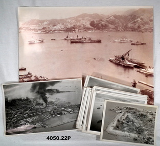
Photograph - PHOTOGRAPHS, KOREA, 1950-1953
... .1) Photo, sepia tone, aerial view over a harbour... shelling. .3) Photo, black & white, aerial view of island ...The photos are a collection held by T. J. IRELAND C/K853677 P.O. STOKER MECHANIC RN while serving on HMS TRIUMPH, Korea 1950-53. Many are of the landings at INCHON, Sept. 1950. .1) Kure Harbour, Japan 1950. Ships assembling for the landings at INCHON, Korea. Ships across the top, left to right: HMAS SYDNEY, Fleet Oiler, VSS ANTIETAM, Hospital Ship & Japanese Coaster. In the foreground on the right, HMS BELFAST, HMS TRIUMPH, HMS CONSORT. On rear most photos are written on in blue pen. .2) INCHON landings Walmi-Do in background and landing barges - could be one I was driving. .3) Island - Walmi-Do - US landing craft. .4) INCHON landings. .5) US landing craft. .6) INCHON oil tanks and military targets on fire. .7) Grounded coaster after an air attack. .8) Two North Korean supply ships hit by rockets. .9) Korean supply vessels camouflaged. .10) Rocket attack on Korean supply vessel. .11) Sunken coaster that was carrying arms and food. .12) Sunken coaster in harbour. .13) & .14) North Korean armour taken from an observation flight. .15) & .16) Chinese tanks and armour. .17) HMS BELFAST, Fleet Oiler, HMAS WARRAMUNGA .18) Targets from rocket attacks. .19), .20) & .21) "Seafires" coming to land on HMS TRIUMPH. .22) Rearming cannon and rockets on a "Seafire'. Photos not written on, information was supplied by T.J. IRELAND. The "Seafire" was a naval adaption of the Supermarine Spitfire for carrier use..1) Photo, sepia tone, aerial view over a harbour with warships, bomb damage foreground, hills and buildings in the distance. .2) Photo, black & white, aerial view of harbour, city with several fires from shelling. .3) Photo, black & white, aerial view of island with landing craft. .4) Photo, black & white, aerial view over ships and harbour. .5) Photo, black & white, aerial view over four landing craft. .6) Photo, black & white, aerial view over city and fires. .7) Photo, black & white, aerial view over islands, boat .... small island. .8) Photo, black & white, aerial view over harbour with two boats on fire. .9) Photo, black & white, aerial view over structures covered. .10) Photo, black & white, aerial view over ship being attacked. .11) Photo, black & white, aerial view over harbour with sunken ship. .12) Photo, black & white, aerial view showing harbour, fire and sunken ship. .13) Photo, black & white, aerial view, five tanks along a road. .14) Photo, black & white, aerial view, same area as .13) showing a wider area. .15) Photo, black & white, aerial view showing tanks and armour. .16) Photo, black & white, aerial view road with armour, vehicles, people and smoke in distance. .17) Photo, black & white, aerial view showing three ships together. .18) Photo, black & white, aerial view showing a road control with targets either side on fire. .19) Photo, black & white, aerial view with aeroplane coming onto the deck of a carrier. .20) Photo, black & white, aerial view of a fighter plane. .21) Photo, black & white, on deck of a carrier. .22) Photo, black & white, rearming a plane with ammunition on carrier deck. Photos are various sizes.photos, korea, rn, inchon -
 Bendigo Military Museum
Photograph, c.WWII
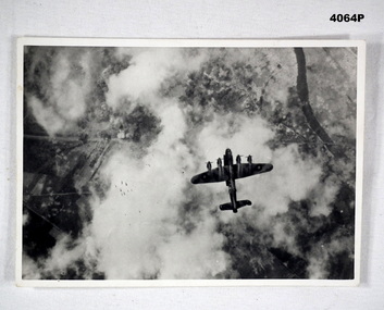
Photograph of a Lancaster bomber on a bombing mission. Bombs released by the aircraft are visible. Part of Frederick Gardner Davey DFC No.410533 RAAF collection. See Cat. No. 3536P for his service record.Photo, black & white, white border, aerial photograph of an aircraft dropping a stick of bombs over a target. Ground target partially visible through clouds.On back, handwritten in blue ink: "I.M. Davey Pres. C.W.A. Strathdale. 'Stick of bombs going down'".bombing run, photography, ww2 -
 Bendigo Military Museum
Photograph - PHOTOGRAPH RAAF WW2, 1939 - 1946
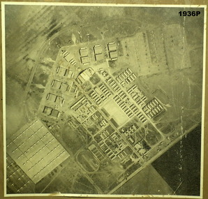
... of site written on rear of photo in biro. photography aerial ...Item in the collection re Maxwell Matheson RAAF. History of site written on rear of photo in biro.Air photo of RAAF base. Mounted on cardboard. No. 6 service flying training school, Mallala SA. Large writer description. Photo shows very large quantity of Avro Ansons, revetments & building.On rear - "No. 6 Service Flying Training School, RAAF, Mallala"photography, aerial photos, mallala -
 Bendigo Military Museum
Photograph - PHOTOGRAPHS, BURMA, 26th Nov 1944
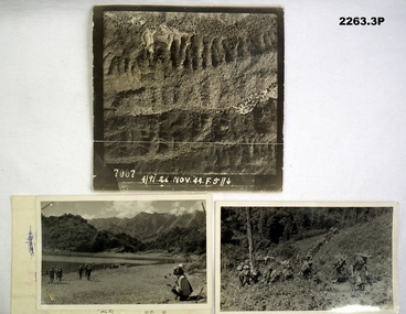
Items in the collection re Ian McLeod RWAFF, refer Cat No 2262.2.1) Aerial Sepia photograph countryside Burma. .2) Black and White photo Burma river, mountains and "kumi" natives. .3) Black and White photograph Burmese Jungle..1) “4191. 26 Nov. 44” .2) “Burmese Campaign 1944” .3) “Burmese Jungle 1944”burma, aerial, photographs -
 Phillip Island and District Historical Society Inc.
Photographs/Slides, Laurie Dixon, 1960's
... photo. 273-02. Aerial view of the old and new bridges looking... up of same photo. 273-02. Aerial view of the old and new ...Four of a collection of slides taken by Laurie Dixon. (Scanned by E Alexander) The new bridge was built in 1968.Four coloured photographs scanned from slides. Three aerial views. 273-01. Aerial view of the old and new bridges and Newhaven, San Remo and Churchill Island - extra close up of same photo. 273-02. Aerial view of the old and new bridges looking towards Cape Woolamai on the top right. 273-03. Aerial view of the Cowes Pier and township - extra close up of same photo. 273-04. Looking down the Cowes Pier towards the township with Isle of Wight Hotel in the background.273-03. Inscription on the slide: Cowes from the air Jan 1968.phillip island suspension bridge, two bridges phillip island, san remo, newhaven, laurie dixon, cowes pier, cowes pier phillip island -
 Phillip Island and District Historical Society Inc.
Photographs, Kodak, Early 20th Century to mid 20th Century
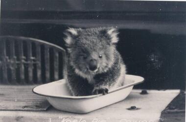
A collection of a group of photographs donated to the Society by Lun Blom, from the Photo Shop in Thompson Avenue, Cowes (was opposite the museum)A collection of 19 photographs of Phillip Island and surrounds. 293-01. Koala sitting in enamel bowl on table 293-02. 20 farmers having a break. 293-03. Reproduction of painting of The Nobbies. 293-04. Photograph of a Trophy for 1st prize for ploughing won by Mr L Morrison 1859. 293-05. Photograph of three men standing in front of a motor vehicle. 293-06. Photograph of view of Cleeland's House at Cape Woolamai. 293-07. Photograph of a whale beached on Phillip Island with people standing around it. 293-08. Photograph of a family and children in front of car - unknown. 293-09. Photograph of a painting of "Innishowen" Harbison's Property. Mr Harbison's portrait inset on the painting. 293-10. Photograph of an early map - possibly drawn by Bass & Flinders. 293-11. Photograph of the San Remo-Westernport Hotel, with vehicles in front. 293-12. Photograph of a fishing boat at the San Remo Jetty with the township in the background. 293-13. Photograph of a couta boat under full sail in Westernport. 293-14. Photograph of an aerial view of the Two Bridges taken from San Remo side. 293-15. Photograph of the Mutton Bird Eggers Camp - Bergins Bay Cape Woolamai. 293-16. Photograph of a Steam ferry decorated with flags. 293-17. Photograph of Fisherman's hut at Cowes with pier in the background. Possibly Mr Cox's. 293-18. Photograph of a couple standing on the bridge in Lover's Walk Cowes. 293-19. Photograph of an aerial view of Phillip Island looking towards Mornington Peninsula and the Heads to Port Phillip Bay in the distance.293-01. "Koala Pie" Cowes. 293-06. Mr Cleeland's Station. 293-09. "Innishowen" Mr. Harbison. 293-10. Phillip Island. 293-17. Phillip Island - Fisherman's Hut, Cowes. 293-18. Phillip Island - Lover's Walk, Cowes.wildlife - koala, wildlife - whale, the nobbies, ploughing trophy, cape woolamai - cleeland's house, innishowen, mr harbison, phillip island map, westernport hotel san remo, fishing boat san remo pier, couta boat westernport, the two bridges san remo, mutton bird eggers camp, steam ferry, fisherman's hut cowes, lover's walk cowes, aerial view of phillip island, lyn blom -
 Phillip Island and District Historical Society Inc.
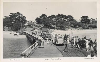
Photograph - Post Cards, A. J. Murray et al, c 1940
... ". Photo 02. Aerial view of "Broadwater" Cowes, Phillip Island.... Aerial view of "Broadwater" Cowes, Phillip Island. No. 146 Photo ...A collection of 6 postcards and 1 photograph taken around Phillip Island. Donated by Julie Barnett.Photograph 228-01. Black & White photograph of the Cowes Pier with vehicles and pedestrians. Rail tracks on pier. Isle of Wight Hotel in background. Sheds at end. Photograph 228-02. Black & White aerial photograph of "Broadwater" Guesthouse, Cowes. Photograph 228-03. Black & White photograph of Cowes Pier with Steamer coming in. Shed at end of Jetty and Cenotaph in the foreground. Looking north. Photograph 228-04. Black & White photograph of a Koala and her young. Photograph 228-05. Black & White photograph looking over the Cowes shoreline near Lover's Walk. Photograph 228-06. Black & White photograph of a group of penguins coming home at dusk at the "Penguin Parade". Photograph 228-07. Black & White photograph of Bert West holding a Shearwater (Mutton Bird) with it's wings outstretched.Photo 01. "Photo Shop Series". "Cowes from the Jetty". Photo 02. Aerial view of "Broadwater" Cowes, Phillip Island. No. 146 Photo 03. "Photo Shop Series". The Jetty. Cowes. Photo 04. "Photo Shop Series". "Koala Bear". Phillip Island Photo 05. "The Rose Series P3416". "Near the Lovers' Walk, Cowes, Phillip Is., Vic. Photo 06. "Penguins, Phillip Island." No. 82. Valentines Series. Photo 07. On Back: Mr West with Mutton bird at Phillip Island.wildlife - koalas, wildlife - penguins, penguin parade, bert west, wildlife - mutton birds, mutton birds, shearwaters, cowes pier phillip island, cowes jetty, lover's walk cowes, broadwater guesthouse cowes phillip island, guesthouses cowes phillip island, julie barnett -
 Phillip Island and District Historical Society Inc.
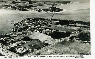
Photograph - Post Card, 1954
One of a collection of photographs donated by Daryl JohnsBlack & White photograph of aerial view over water and land. Newhaven in foreground and San Remo at rear of suspension bridge."The Rose Series P.14000. Aerial view showing Newhaven, San Remo & Suspension Bridge." Airspy Photo.phillip island, newhaven, san remo, daryl johns -
 Phillip Island and District Historical Society Inc.
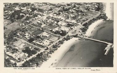
Photograph - Post Card, Unknown
Donated by Stan McFee from the Keith McIlwraith Collection.Black & White postcard showing an aerial view of Cowes Town Centre, beach and pier."The Rose Series P. 1022" "Aerial view of Cowes, Phillip Island." "Airspy Photo".cowes phillip island, cowes foreshore and pier, phillip island, stan mcfee, keith mcilwraith collection -
 Phillip Island and District Historical Society Inc.
Photograph
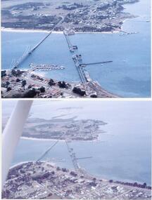
Photograph from The Herald and donated by Jack MorrisonBlack & White Aerial Photograph showing the two bridges between Newhaven and San Remo, the old and the new. (Same photo as 100-09, reduced in size)local history, photography, photographs, slides, film civil engineering, bridges, history of the phillip island bridge, black & white photograph, phillip island bridges -
Phillip Island and District Historical Society Inc.
Photograph
Phillip Island suspension Bridge built 1938/1940 - demolished 1970. Part of an album compiled and donated by Mrs Helen Jansson.Print of Phillip Island Suspension Bridge. Aerial view showing Jetties at left with sweep of sandy beaches middle to top left.No. 1. Phillip Island Bridge, Victoria. Airapy Photolocal history, photography, photographs, slides, film, civil engineering, bridges, jetties, phillip island suspension bridge, black & white photograph, mrs. helen jansson, suspension bridges, phillip island -
 Greensborough Historical Society
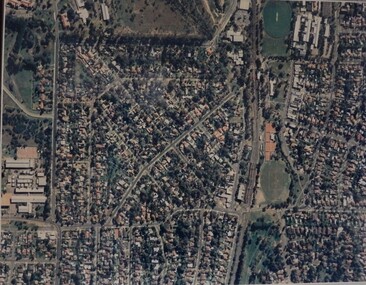
Aerial Photograph, Macleod, 1980c
... of 5994. macleod Laminated colour aerial photograph Macleod Aerial ...Covers Macleod area. Section of 5994.Laminated colour aerial photographmacleod -
 Greensborough Historical Society
Aerial Photograph, Photo-mapping Services Pty Ltd, Macleod, 1980c
... aerial photograph Macleod Aerial Photograph Photo-mapping ...Covers Macleod, Bundoora and Greensborough areasLaminated colour aerial photographmacleod, bundoora, greensborough -
 Greensborough Historical Society
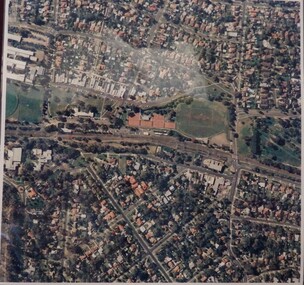
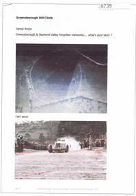
Article and Photograph, Greensborough Hill Climb, 2017_
Information and photos about the Greensborough Hill Climb included a copy of the 1945 aerial survey showing the track.This photograph and text was copied from a Facebook site. Members are people who lived in the Greensborough area and share their reminiscences of the area with others. The site is administered by a GHS member but is not officially affiliated with the Society. Any information is the opinion of the contributor. Article and photograph sourced from social media.greensborough hill climb 1945, bill halliburton -
Glenelg Shire Council Cultural Collection
Photograph - Photograph - Aerial photograph of an area of Portland, Victoria, 1955
Port of Portland CollectionA black and white aerial photograph taken from the N.W. of T.B.& S. abattoir, red brick wool store, petroleum installations, north/central Portland residential areas and Portland Harbour.Front: NOV 1955 'AIRSPY PHOTO' ref NO 2/b/74port of portland -
Glenelg Shire Council Cultural Collection
Postcard - Postcard - Portland Harbour, c. 1970
... Coloured photo postcard, serrated edge. Aerial view... of Portland Harbour' Coloured photo postcard, serrated edge. Aerial ...Coloured photo postcard, serrated edge. Aerial view of Portland and harbour, 1970sBack: Maker details. 'Portland Vic, Aerial view of Portland Harbour'postcard, aerial view of portland harbour -
Glenelg Shire Council Cultural Collection
Photograph - Photograph - aerial view of train track between Heywood and Rennick, 03/05/1952
Black and white aerial photographs (aerial survey record print) of the railway line between Heywood and Rennick (S.A. border) Taken for Victorian Railways, May 1952. Some photos have annotations later added to the front of the image in penVictorian Railways aerial survey record print of the railway line between Heywood and Rennick (S.A. border) Black and white, white vertical strip on imageFront: Annotations in red ink added at a later date Back: 'Heywood - Rennick 21579 - 19842 279m 57c ' - all black ink. Purple VR aerial survey stamp. '3 May 1952' - black stampvictorian railways, train track, transport, travel -
Glenelg Shire Council Cultural Collection
Photograph - Photograph - aerial view of railway between Heywood and Rennick, 03/05/1952
Black and white aerial photographs (aerial survey record print) of the railway line between Heywood and Rennick (S.A. border) Taken for Victorian Railways, May 1952. Some photos have annotations later added to the front of the image in penVictorian Railways aerial survey record print of the railway line between Heywood and Rennick (S.A. border) Black and white, white vertical strip on imageBack: 'Heywood - Rennick 21389 - 19660 261m 3c ' - all black ink. Purple VR aerial survey stamp. '3 May 1952' - black stampvictorian railways, train track, transport -
Glenelg Shire Council Cultural Collection
Photograph - aerial view of train track between Heywood and Rennick, 03/05/1952
Black and white aerial photographs (aerial survey record print) of the railway line between Heywood and Rennick (S.A. border) Taken for Victorian Railways, May 1952. Some photos have annotations later added to the front of the image in penVictorian Railways aerial survey record print of the railway line between Heywood and Rennick (S.A. border) Black and white, white vertical strip on imageFront: Annotations in red ink added at a later date Back: 'Heywood - Rennick 21578 - 19841 279m 49c Rennick ' - all black ink. Purple VR aerial survey stamp. '3 May 1952' - black stampvictorian railways, train track, travel, transport -
Glenelg Shire Council Cultural Collection
Photograph - Photograph - aerial view of the train track between Heywood and Rennick, 03/05/1952
Black and white aerial photographs (aerial survey record print) of the railway line between Heywood and Rennick (S.A. border) Taken for Victorian Railways, May 1952. Some photos have annotations later added to the front of the image in penVictorian Railways aerial survey record print of the railway line between Heywood and Rennick (S.A. border) Black and white, white vertical strip on imageFront: Annotations in red ink added at a later date Back: 'Heywood - Rennick 21577 - 19840 279m 41c ' - all black ink. White sticker, black print 'Rennick' Purple VR aerial survey stamp. '3 May 1952' - black stampvictorian railways, travel, train, transport -
Glenelg Shire Council Cultural Collection
Photograph - Photograph - aerial view of train track between Heywood and Rennick, 03/05/1952
Black and white aerial photographs (aerial survey record print) of the railway line between Heywood and Rennick (S.A. border) Taken for Victorian Railways, May 1952. Some photos have annotations later added to the front of the image in penVictorian Railways aerial survey record print of the railway line between Heywood and Rennick (S.A. border) Black and white, white vertical strip on imageBack: 'Heywood - Rennick 21453 - 19724 267m 19c ' - all black ink. Purple VR aerial survey stamp. '3 May 1952' - black stampvictorian railways, train track, transport, travel -
Glenelg Shire Council Cultural Collection
Photograph - Photograph - aerial view of Portland coastline, c. 1954
... , lower border Black and white aerial photograph of coastline ...Black and white aerial photograph of coastline around Portland. Black border, scale all sides, 5 rows of 3 't' at regular intervals. Buildings visible most areas of photoFront: '607 -107' -- handwritten, white, lower border 'RUN 5' 'PORTLAND', printed, white, lower border -
Glenelg Shire Council Cultural Collection
Souvenir - Tourism Booklet - 'Discovering Portland', Discovering Portland, n.d
Thirteen page booklet 'Discovering Portland', by Carol White. Glossy heavy card covers, lighthouse on front, aerial view of Portland Island, Dorset, UK on back. Coloured photos and descriptions of places of interest on Portland. -
Glenelg Shire Council Cultural Collection
Photograph - Aerial Survey Railway Record Print - 1952, 03/05/1952
These photos were found in a car that was left for recycling.Victorian Railways aerial survey record print of the railway line between Heywood and Rennick (S.A. border) Black and white, white vertical strip on image.Front: 'to Rennick, Heywood from Melbourne' in the white strip Back: 'Heywood - Rennick 21069 - 19360. 235m31c Heywood' - all black ink. Purple VR aerial survey stamp. '3 May 1952' - black stamp -
Glenelg Shire Council Cultural Collection
Photograph - Aerial Survey Railway Record Print - 1952, 03/05/1952
These photos were found in a car that was left for recycling.Victorian Railways aerial survey record print of the railway line between Heywood and Rennick (S.A. border) Black and white, white vertical strip on image.Back: 'Heywood - Rennick 21293 - 19565 254m 10c Greenwald'- all black ink. Purple VR aerial survey stamp. '3 May 1952' - black stampvictorian railways -
Glenelg Shire Council Cultural Collection
Photograph - Photograph - N.W., of T.B.& S. abattoir; red brick wool store; petroleum installations; north/central Portland residential areas and Portland Harbour, 1955
Port of Portland CollectionFront: NOV 1955 'AIRSPY PHOTO' ref NO 2/b/74port of portland archives, portland harbour, portland residential areas, tb and s abattoir, red brick wool store, petroleum installations