Showing 33204 items matching "buildings/streetscapes"
-
 Buninyong & District Historical Society
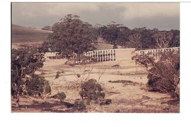
Photograph - Original Photograph, Ballarat Institute of Advanced Education (Federation University), 1969
Colour photograph of construction of first buildings of Ballarat Institute of Advanced Education 1970The construction of the Mt. Helen campus in the 1970s was an important milestone in the expansion of tertiary education in the Central HighlandsColour photograph of Ballarat Institute of Advanced Education 19701969-70 1st buildings at Mt. Helen Campuseducation, mount helen campus, green hill, ballarat institute of advanced education, federation university -
 Peterborough History Group
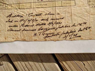
Map - Map of Peterborough House 1921, 1921
This hand drawn map of the buildings and out buildings was done for insurance purposes. It indicates which buildings are covered and which are uninsured. Significant as it shows a plan of the hotel as it was in 1921. Each building is labelled by its purpose, which provides an interesting insight into holidays of the time. For example, 'sleep outs' and external bathrooms. A4 photocopy of a hand drawn map of the buildings and out buildings comprising Peterborough House. Hand drawn map -
 Buninyong Visitor Information Centre
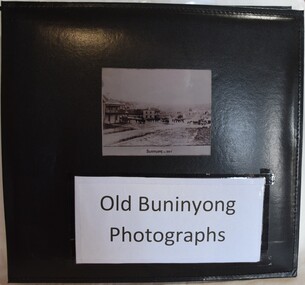
Album - Photograph Album, Old Buninyong Photographs (Early Buninyong)
... Streetscapes ...The album was compiled by Derek Leather using photographic reproductions of images of Buninyong. The album includes early maps, streetscapes, monuments and buildings.Significant images of nineteenth century Buninyong streetscapes.Black, hard-covered album with thirty-two fixed photographs and five lose photographs. Compiled by Derek Leather, former Shire of Buninyong councillor. Old Buninyong Photographsbuninyong, derek leather, streetscapes -
 Bendigo Military Museum
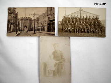
Postcard - POSTCARD, PHOTOGRAPHIC
Postcards of day often held actual photos on front side. Re collection of "John Arthur Remington Alexander" No. 2237, AFC, AIF. Refer Cat 7820 for his service details.1. Black and white postcard photo of the streetscape of "The Bargate, Southampton". On the back is a message from "Andy" to Jack (presumably J.A.R. Alexander). 2. Formal picture of rows of serviceman in uniform in front of some buildings. Postcard space on back is empty. 3. 1. Letter to Jack from Andy. 2. Nil. 3. Says "Love to Daddy from Jack" "Baby held pen to sign above".postcards, ww1, john arthur remington alexander -
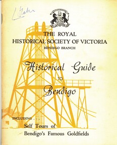 Bendigo Historical Society Inc.
Book - HISTORICAL GUIDE TO BENDIGO, INCLUDES SELF TOURS OF BENDIGO'S FAMOUS GOLDFIELDS, 1968
Historical Guide to Bendigo. Contains Self Tours of Bendigo's Famous Goldfields. Also contained within are photos of Trams, Building, Streetscapes, and Mines. Produced by the Bendigo Branch of The Royal Historical Society of Victoria, which was compiled from material supplied by members.Produced by the Bendigo Branch of The Royal Historical Society of Victoriabendigo, history, city history. the goldfields. -
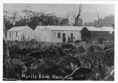 Halls Gap & Grampians Historical Society
Photograph - B/W, C 1912- 1913
... BUILDINGS ...Early stages of buildings with Warren family before becoming Guest HouseBuilding with residents in foreground with additional buildings1 photo mounted on cardboardbuildings, myrtlebank, people, warren -
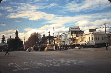 Bendigo Historical Society Inc.
Slide - CASTLEMAINE HISTORICAL SOCIETY COLLECTION, ALEXANDRA FOUNTAIN, 1955
Slide. Alexandra Fountain, Charing Cross, Bendigo. Pall Mall streetscape in background. Dated 28.5.55slide, bendigo, alexandra fountain, castlemaine historical society collection alexandra fountain charring cross bendigo -
 Robin Boyd Foundation
Slide, Robin Boyd, 1969
Colour slide in a mount. Streetscape Victoria St (looking east), corner of Lambert St, Richmond.Made in Australia / 35 / JUL 69M / Encircled 2A (Handwritten)slide, robin boyd -
 Robin Boyd Foundation
Slide, Robin Boyd, 1956-1957
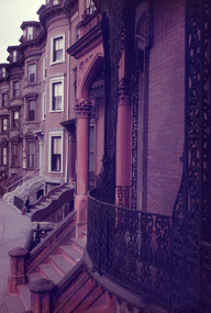
Robin Boyd developed a close friendship with the founder of the Bauhaus in Weimar Germany, Walter Gropius, who had moved to the USA in the 1930s. Through this connection, Boyd was invited to be the Massachusetts Institute of Technology (MIT) Bemis Professor at the School in the North American academic year 1956-7. Robin and Patricia Boyd, with their youngest daughter Suzy, were based in Cambridge, Massachusetts for the year. Boyd gave some lectures at MIT and he was also invited to give lectures at many other universities, allowing him to travel widely within the USA, especially on the East Coast. This gave him the opportunity to meet architects like Frank Lloyd Wright, Eero Saarinen, Paul Rudolph and many others, and visit the offices of Skidmore, Owings and Merrill, and places like Taliesin and the General Motors Technical Center Detroit. On the way home, the Boyds visited London, Berlin, Paris and Le Corbusier’s Ronchamp Chapel in France.Colour slide in a mount. Brownstone streetscape east coast, possibly New York or Boston, USAMade in USA / Patentedmit bemis professorship, mit, robin boyd, slide -
 Ballarat Tramway Museum
Photograph - Black & White Photograph/s, HSN, 20/11/1932 12:00:00 AM
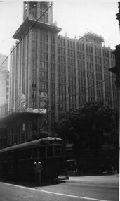
Black and white photograph of a westbound W2 in Collins St. Melbourne at the intersection with Swanston St with the Manchester Unity building in the background and parts of the Melbourne Town Hall alongside. The Manchester Unity building is under construction with the towers being completed. Tram showing destination of "CITY" and has a person standing alongside - see inscriptions.In pencil on the rear - "The escalator building / Ken standing in front of the tram / HSN / 20/11/32"trams, tramways, collins st, swanston st, manchester unity, melbourne -
 Hume City Civic Collection
Photograph, Early 1990's
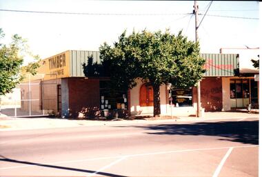
The building suppliers and timber yard has been demolished and a Centrelink Office and car park area has been built on the site. The adjacent shop is now a Youth Resource Centre.A coloured photograph of part of a streetscape on the east side of Evans Street featuring the timber supply yard and 3 other shops. A plane tree has been planted at the edge of the footpath and there are high cyclone gates into the timber yard.building suppliers, timber yards, shopping centres, evans street, george evans collection -
 Kew Historical Society Inc
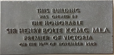
Plaque - Commemorative Plaque, Institute of Early Childhood Development, This building was opened by the Honorable Sir Henry Bolte KCMG MLA, Premier of Victoria, on the 10th December 1969, 1969
The Free Kindergarten Union of Victoria commenced teacher training in 1909. A two year course was run in cooperation with the Education Department in 1910-14, but from 1917 the Union trained its students independently. In 1922 the Kindergarten Training College was established in Mooroolbeek, Kew. In 1965, the institution, as the Melbourne Kindergarten Teachers' College, became an entity separate from the Union, and in 1973 joined the State College of Victoria as the Institute of Early Childhood Development. It subsequently amalgamated with the University of Melbourne to become the Department of Early Childhood Studies and moved from Madden Grove, Kew, to 234 Queensberry St, Carlton, early in July 1997.Metal alloy plaque commemorating the opening of a building by the Premier of Victoria, Sir Henry Bolte, on 10th December 1969This building was opened by the Honorable Sir Henry Bolte KCMG MLA, Premier of Victoria, on the 10th December 1969sir henry bolte, commemorative plaques - kew (vic), institute of early childhood development -
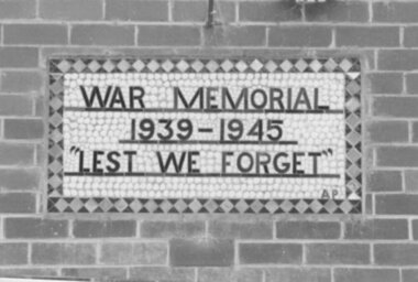 Clunes Museum
Photograph, PLAQUE AT SWIMMING POOL, 1987
WAR MEMORIAL PLAQUE DESIGNED AND MADE BT ARTHUR PICKFORD, BUILD INTO WALL OF ORIGINAL DRESSING ROOM AT VICTORIA PARK BUILDING DEMOLISHED FEB. 1987 TO PREPARE SITE FOR COMMUNITY COMPLEX.COLOUR PHOTOGRAPH PLAQUE AT CLUNES SWIMMING POOL CHANGE ROOMS DEMOLISHED 20/2/1987.BUILDING - FOOTBALL / CRICKET CLUB AT VICTORIA PARK.photographs, plaque at swimming pool -
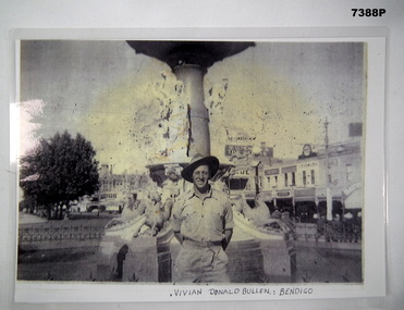 Bendigo Military Museum
Photograph - PHOTOGRAPH, WW2, C. WW2 (ORIGINAL PHOTOGRAPH)
Item in the collection re Vivian BULLEN, refer Cat No 7386 for his AIF & RAAF service details.PHOTOCOPY OF AN ORIGINAL PHOTOGRAPH. PHOTOGRAPH - BLACK AND WHITE ON PHOTOGRAPHIC PAPER WHICH HAS BEEN LAMINATED. Depicts "VIVIAN DONALD BULLEN", Bendigo - Soldier in uniform and slouch hat standing in front of a fountain with streetscape of buildings in the background. Handwritten information below photograph.Below photograph - handwritten, black ink. "VIVIAN DONALD BULLEN: BENDIGO"photograhs, ww2, army, bendigo, vivian donald bullen -
 Tatura Irrigation & Wartime Camps Museum
Booklet, Streetscape, 1998
Printed in 1998 as a record of the exhibition held at Shepparton Art Gallery, July, 1998. Booklet deals with early architecture in Shepparton Region, includes maps, plans, photographic images and catalogue of 100 years of progress. Soft cardboard, light grey background with Shepparton Post Office fascade and first floor plan on front cover, view of the building from Wyndham Street and ground floor plan on back cover. The word "streetscape" printed across front seven times. early buildings, shepparton art gallery exhibitions, shepparton architecture, shepparton photographic images -
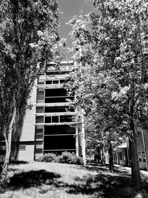 Federation University Historical Collection
Building T Mount Helen Campus, by Lucie Akers
... Buildings ...Building T Mount Mount Helen CampusBuilding T Mount Helen Campus / Brutalist style architecture / middle section of T building adjacent to Building A brutalism, federation university mount helen campus, buildings, mount helen campus, building t -
 Charlton Golden Grains Museum Inc
Photograph, Pollard, Jenny, East end of High St Charlton, south side 1989, c.1989
K.V. CHARLTON rebuilt after fire in 1976 by R. Lowe. Sold to John Sutton. Photograph is part of Jenny Pollard's streetscape series taken in 1989 for Charlton Shire.Colour photograph showing K.V, Charlton service station. Three men in front on the footpath. Two petrol bowsers on RH side of service station. Post Office on right of service station. Signage on building says MASSEY FERGUSON K.V. CHARLTON HOLDENk.v. charlton service station, r. lowe, john sutton, charlton, business, industry, post office -
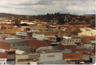 Bendigo Historical Society Inc.
Photograph - VIEW FROM OLD BENDIGO POST OFFICE CLOCK TOWER LOOKING SOUTHWEST TOWARDS QUARRY HILL
... buildings/streetscapes ...View from old Bendigo Post Office Clock Tower South West in the direction of Quarry Hill. Names that appear on buildings are Coles, McCalmans, Bolton printers, New World Supermarket, Hopetoun hotel Target, and above these show buildings on the Bendigo Railway Station site.bendigo, history, buildings/streetscapes, coles, mccalmans, printers (boltons), new world supermarket, target, hopetoun hotel, and railway yards and buildings. -
 Federation University Historical Collection
Photograph, Ballarat School of Mines Administration Building
This building was started in 1899 and was opened in 1901.Rear view of the Ballarat School of Mines Administration Building (A Building) ballarat school of mines, administration building, a building -
 Kew Historical Society Inc
Plan, Melbourne & Metropolitan Board of Works : Borough of Kew : Detail Plan No.1302, 1910
The Melbourne and Metropolitan Board of Works (MMBW) plans were produced from the 1890s to the 1950s. They were crucial to the design and development of Melbourne's sewerage and drainage system. The plans, at a scale of 40 feet to 1 inch (1:480), provide a detailed historical record of Melbourne streetscapes and environmental features. Each plan covers one or two street blocks (roughly six streets), showing details of buildings, including garden layouts and ownership boundaries, and features such as laneways, drains, bridges, parks, municipal boundaries and other prominent landmarks as they existed at the time each plan was produced. (Source: State Library of Victoria)This plan forms part of a large group of MMBW plans and maps that was donated to the Society by the Mr Poulter, City Engineer of the City of Kew in 1989. Within this collection, thirty-five hand-coloured plans, backed with linen, are of statewide significance as they include annotations that provide details of construction materials used in buildings in the first decade of the 20th century as well as additional information about land ownership and usage. The copies in the Public Record Office Victoria and the State Library of Victoria are monochrome versions which do not denote building materials so that the maps in this collection are invaluable and unique tools for researchers and heritage consultants. A number of the plans are not held in the collection of the State Library of Victoria so they have the additional attribute of rarity.Original survey plan, issued by the MMBW to a contractor with responsibility for constructing sewers in the area identified on the plan within the Borough of Kew. The plan was at some stage hand-coloured, possibly by the contractor, but more likely by officers working in the Engineering Department of the Borough and later Town, then City of Kew. The hand-coloured sections of buildings on the plan were used to denote masonry or brick constructions (pink), weatherboard constructions (yellow), and public buildings (grey). The absence of buildings and or property in Kew facing the Yarra is the most notable feature of this plan. Walmer Street and its bridge stretched, then and now, from Studley Park Road to Victoria Street, Richmond. On the Richmond side of the Yarra, there was evidence in 1904 of industry (‘Wool shed’; Soap Works’) and entertainment (‘Skittle Alley’). In reality, another Plan (No.1303) shows Chinese Gardens bordering the Yarra on the Kew side and buildings in Young Street.melbourne and metropolitan board of works, detail plans, mmbw 1302, cartography -
 Falls Creek Historical Society
Photograph - Dick Stericker & Hans Fisher building bridge 1961
This item is from the private collection of George Shirling of Red Onion, Falls Creek. It depicts Dick Stericker & Hans Fisher constructing a wooden bridge. They both arrived in Falls Creek in the early 1960s. Hans worked on the slopes in summer and in winter, including building access bridges over the race-line as shown in this photograph. In 1965 Hans started as the chef Koki Alpine Lodge owned by George Shirling. He later worked as cook at various Falls Creek eating houses, as well as working for the lift company and slope maintenance People like Hans made Falls Creek. He passed away at Noosa, Queensland on 18th January 2022. George Shirling arrived in Falls Creek in 1962. He engaged Phil Nowell to build the original Koki Alpine Lodge which opened in 1965 with 14 beds. George operated the lodge with Michael “Baldy” Blackwell as manager. He also graduated in sport psychology in 1981 and was invited to become team psychologist for the Australian Winter Olympic team which went to Albertville, France, in 1992. He later owned the Red Onion Chalet. George credited the success of Koki to “Baldy” Blackwell. “Baldy” and Phil Nowell started the Trackers Mountain Lodge in partnership during the 1980s. In 1971 George sold Koki Lodge to Sigi Doerr. In 2024 the renamed Koki Alpine resort remains a highly popular destination in Falls Creek. George Shirling passed away on 27th February 2023. He had remained actively involved in Falls Creek and was generous with his time and knowledge, always an amazing supporter of The Falls Creek Museum and Falls Creek Village.This item is significant because it features two prominent members of the Falls Creek community.A black and white photograph of Dick Stericker & Hans Fisher taking a break whilst building a bridge. A typed George Shirling Collection number and description is attached. On label: ITEM NO. 148 Dick Stericker & Hans Fisher - smoko - while building bridge over raceline - Village T-bar, 1961george shirling, red onion, hans fisher -
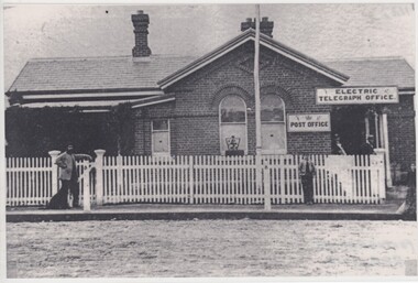 Rutherglen Historical Society
Image, 1900-1910 Approximate
Donated by Mr Greg Thomson, a former resident of RutherglenBlack & white reproduction, unframed, laminated. This reproduction is of the Rutherglen Post-Office as it was in the 1900s. The residence (to the left of pen mark cross on picket fence) has since been demolished and today that is where the present Post-Office stands, building to right of cross still stands. Original building built in 1863, altered in 1910Signs on front of building: "Electric Telegraph Office. Post Office" On back of photo: "Photographed pre 1910"rutherglen post office -
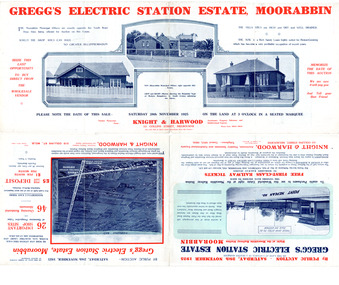 City of Moorabbin Historical Society (Operating the Box Cottage Museum)
Flyer - Gregg's Electric Station Estate, Moorabbin, 1925
The train line from the city to Frankston was electrified which intensified the sale in the municipality of Moorabbin, particularly land which was in the vicinity of the railway stations.Example of the progress of the Municipality of MoorabbinAdvertising flyer for auction of real estate sales - plan of building blocks for saleGregg's Electric Station Estate, Moorabbin 26 business site and 46 home sites - Knight & Harwood pictures of local sites and buildingssouth road, barry street, south avenue, plym street, moorabbin, moorabbin station, gregg, real estate, auction -
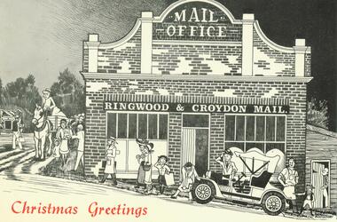 Ringwood and District Historical Society
Card, Jack Montgomery, Ringwood Mail Christmas Greetings Card with potted history 1965.Reproduced from the original drawings completed on site by Artist-Historian, Jack Montgomery
Christmas Greetings Card from Ringwood and Croydon Mail, with sketch of the Mail Office on the front, and a potted history of the building inside the card. At the end of the summary: "Reproduced from the original drawing of THE OLD RINGWOOD MAIL" by Artist-Historian Jack Montgomery, Upwey Vic". "Drawn from Sketches completed on the Site -1965"Printed inside cover of card is a potted history of the building. -
 Clunes Museum
Artwork, other - ARTWORK, Anderson, Ian L, Clunes Streetscape, 1999
Framed pen and pastel drawing of the Town Hall, Clunes. Framed painted gold, cream coloured mat boardOn reverse: Clunes Streetscape, Pen & Pastel by Ian L Anderson, (address & telephone number (private), signed Ian L Anderson Nov 99clunes town hall, pen & pastel, ian l anderson -
 Kew Historical Society Inc
Plan, Melbourne & Metropolitan Board of Works : Borough of Kew : Detail Plan No.1581, 1904
The Melbourne and Metropolitan Board of Works (MMBW) plans were produced from the 1890s to the 1950s. They were crucial to the design and development of Melbourne's sewerage and drainage system. The plans, at a scale of 40 feet to 1 inch (1:480), provide a detailed historical record of Melbourne streetscapes and environmental features. Each plan covers one or two street blocks (roughly six streets), showing details of buildings, including garden layouts and ownership boundaries, and features such as laneways, drains, bridges, parks, municipal boundaries and other prominent landmarks as they existed at the time each plan was produced. (Source: State Library of Victoria)This plan forms part of a large group of MMBW plans and maps that was donated to the Society by the Mr Poulter, City Engineer of the City of Kew in 1989. Within this collection, thirty-five hand-coloured plans, backed with linen, are of statewide significance as they include annotations that provide details of construction materials used in buildings in the first decade of the 20th century as well as additional information about land ownership and usage. The copies in the Public Record Office Victoria and the State Library of Victoria are monochrome versions which do not denote building materials so that the maps in this collection are invaluable and unique tools for researchers and heritage consultants. A number of the plans are not held in the collection of the State Library of Victoria so they have the additional attribute of rarity.Original survey plan, issued by the MMBW to a contractor with responsibility for constructing sewers in the area identified on the plan within the Borough of Kew. The plan was at some stage hand-coloured, possibly by the contractor, but more likely by officers working in the Engineering Department of the Borough and later Town, then City of Kew. The hand-coloured sections of buildings on the plan were used to denote masonry or brick constructions (pink), weatherboard constructions (yellow), and public buildings (grey). The streets and built structures in this plan were surveyed in 1903 and released to contractors in 1904. In addition to the designation of building types by colour, the plan includes detailed descriptions of land use and ownership. While many buildings remain from this period, a number of the buildings represented have been demolished including the original Kew Town Hall, and the Congregational and Roman Catholic churches in Walpole Street. While the mansion ‘Illapa’ in Princess Street is still extant – now part of ‘Rylands’ – the neighbouring mansion ‘Elsmere’ was demolished some decades ago. Rivalling Illapa and Elsmere in size were two mansions in Walpole Street, one named on the plan as ‘Gnarlbine’. Over time, Kew Junction and the south side of High Street have been reconfigured and widened, so that the commercial buildings on the corner of Princess and High Street no longer exist. A surprising feature of this part of central Kew to the northwest of Kew Junction is the amount of vacant land. In a number of cases, this land is noted by the contractor as used for vegetable gardens.melbourne and metropolitan board of works, detail plans, maps - borough of kew, mmbw 1581, cartography -
Tatura Irrigation & Wartime Camps Museum
Photograph, Johnson's Newsagency Streetscape Looking West
... buildings ...Johnson's Newsagent & Stationer, streetscape of Hogan Street looking west. Solicitor's Chambers, CBC Bank. c1935.tatura, buildings, historic, street, furniture, signs, cbc -
 Hume City Civic Collection
Photograph, 1952
B/W photograph of a streetscape in Brook Street, Sunbury. It shows Mr Ron Geyer's Newspaper shop.Handwritten on back: MR RON GEYERS' NEWSPAPER SHOP, IN BROOK STREET, 1952newspapers, shops, businesses, geyer's newspaper shop, brook street, sunbury, streetscape, geyer, ron, 1950s, george evans collection -
Whitehorse Historical Society Inc.
Newspaper - Article, Residents fear for streetscape, 28/09/1994
'Residents fear for streetscape' ' Mitcham Mansion,' (Walker home), Meerut Street, Mitcham, land subdivision opposite.meerut street, mitcham, walker, edgar edwardes, australian tesselated tile co pty ltd, barelli, ken, land subdivision -
Canterbury History Group
Book, Don Gibb et al, Visions of a Village : Canterbury shops and shopping 1880s-1990s, 2007
... Streetscapes ...Focussing on the growth and activities that took place in the shopping and service centre of Canterbury and Maling Roads in Canterbury from the 1880s to the present, it is partly a guide book to the present buildings of the centre through the streetscapes and brief lives of each of the premises.74 pages; black and white illustrations and photographs, including sketches of streetscapes. Includes bibliographical references and indexnon-fictionFocussing on the growth and activities that took place in the shopping and service centre of Canterbury and Maling Roads in Canterbury from the 1880s to the present, it is partly a guide book to the present buildings of the centre through the streetscapes and brief lives of each of the premises.canterbury road shopping centre, maling road, maling road> shops, shops, retail trade, commercial establishments, streetscapes, gibb> don, warmington> stuart