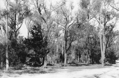
Showing 511 items
matching bushlands
-
 Glen Eira Historical Society
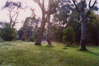
Article - Boyd Park
This file contains two items. Two original photographs of Boyd Park, date unknown. An article from the CAULFIELD/ PORT PHILLIP LEADER on a massive swamp gum tree that was felled by heavy winds in Boyd Park, Murrumbeena, dated 03/08/2012.glen eira, glen eira environment group, smith colin, caine paul, boyd park, murrumbeena, parks, conservation of natural land and energy economics, reserves, bushland, gardens, resources, trees, plants -
 Marysville & District Historical Society
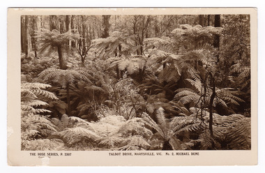
Postcard (item) - Black and white postcard, Rose Stereograph Company, Talbot Drive, Marysville, Vic. No. 2, Michael Dene, 1913-1967
A postcard in a series produced by the Rose Stereograph Company in Victoria, Australia as a souvenir of Marysville.A black and white photograph showing trees and tree ferns, taken along the Michaeldene Trail near Lady Talbot Drive in Marysville in Victoria. The Michaeldene Trail is a level two loop that leads to the Taggerty River Lookout and may be undertaken as either as a Short (2.7 km) Loop, or a Long (4.3 km) Loop - 30 minutes to one hour and a half. The attractive bushland linking the Steavenson and Taggerty Rivers allows walkers and cyclists to step back in time to Marysville’s historic logging past. Sections of this mostly flat circuit follow old tramline alignments, which in places reveal the original timber sleepers on which the big logs were transported to the nearby sawmill.The Taggerty River Lookout offers views over the Taggerty River. The Trestle Bridge was built to span a small gully and provide access to the timber on Red Hill. Lady Talbot Drive is a 24 kilometer scenic rainforest car journey which passes a number of walks and waterfalls in the Yarra Ranges National Park. Lady Talbot Drive is named after Lady Sarah Elizabeth, the wife of Sir Reginald Talbot, who was the Governor of Victoria from 25th April, 1904 to 6th July 1908. This postcard was produced by the Rose Stereograph Company as a souvenir of Marysville.REAL PHOTO POST CARD THE "ROSE"SERIES DE LUXE PRODUCED IN AUSTRALIA Published by "The Rose Stereographs" Armadale, Victoria.marysville, victoria, michael dene, michael dene track, p. 2307, walking track, rose series postcard, postcard, souvenir, lady talbot drive, sarah elizabeth talbot, sir reginald talbot -
 Marysville & District Historical Society
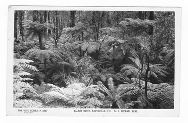
Postcard (item) - Black and white postcard, Rose Stereograph Company, Talbot Drive, Marysville, Vic. No. 2, Michael Dene, 1913-1967
A postcard in a series produced by the Rose Stereograph Company in Victoria, Australia as a souvenir of Marysville.A black and white photograph showing trees and tree ferns, taken along the Michaeldene Trail near Lady Talbot Drive in Marysville in Victoria. The Michaeldene Trail is a level two loop that leads to the Taggerty River Lookout and may be undertaken as either as a Short (2.7 km) Loop, or a Long (4.3 km) Loop - 30 minutes to one hour and a half. The attractive bushland linking the Steavenson and Taggerty Rivers allows walkers and cyclists to step back in time to Marysville’s historic logging past. Sections of this mostly flat circuit follow old tramline alignments, which in places reveal the original timber sleepers on which the big logs were transported to the nearby sawmill.The Taggerty River Lookout offers views over the Taggerty River. The Trestle Bridge was built to span a small gully and provide access to the timber on Red Hill. Lady Talbot Drive is a 24 kilometer scenic rainforest car journey which passes a number of walks and waterfalls in the Yarra Ranges National Park. Lady Talbot Drive is named after Lady Sarah Elizabeth, the wife of Sir Reginald Talbot, who was the Governor of Victoria from 25th April, 1904 to 6th July 1908.REAL PHOTO POST CARD THE "ROSE"SERIES DE LUXE PRODUCED IN AUSTRALIA Published by the Rose Stereographs Armadale, Victoria. Tomorrow is your Official day/ I believe. So Very Very many happy/ returns, & best of luck & good/ wishes from/ your May I rec'd this on/ 1st. (illegible)/ thought it a good snap of our ferns.marysville, victoria, michael dene, michael dene track, p. 2307, walking track, rose series postcard, postcard, souvenir, lady talbot drive, sarah elizabeth talbot, sir reginald talbot -
 Greensborough Historical Society
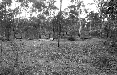
Slide - Photograph, John Ramsdale, Bushland: Slide 84, 1990s
Photograph shows a bush scene in the northern suburbs of Melbourne.Part of the John Ramsdale collection of slides and audio visual material.Colour photograph scanned from slide.No maker's marks. No caption on slide.bushland -
 Greensborough Historical Society
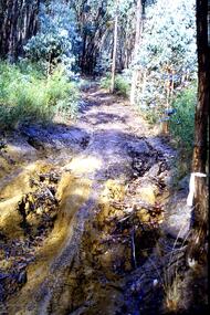
Slide - Photograph, John Ramsdale, Erosion from trail bikes: Slide 36, 1990s
Photograph shows a bush track with erosion caused by trail bikes and water.Part of the John Ramsdale collection of slides and audio visual material.Colour photograph scanned from slide.No maker's marks. No caption on slide.erosion, bushland -
 Greensborough Historical Society
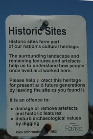
Photograph - Digital Image, Mernda historic sites 2018, 25/07/2019
In 2018 GHS members visited Turner's Bakery in Mernda for lunch and continued on to visit historic sites remaining in the Mernda area. These photographs show remnant bush and the Parks Victoria sign in the area.Mernda is an area of rapid modern growth with a few remaining historic buildings dating from the 19th centuryDigital copy of colour photographsmernda, parks victoria, bushland -
 Greensborough Historical Society
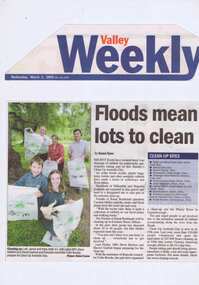
Newspaper Clipping - Digital Image, Barak Bushland Reserve - Floods mean a lot to clean, 02/03/2005
Receding flood water levels have revealed much rubbish. Clean Up Australia day volunteers work throughout Banyule and Nillumbik to collect the rubbish.Newspaper clipping, black and white text and colour image.clean up australia day, plenty river -
 Kiewa Valley Historical Society
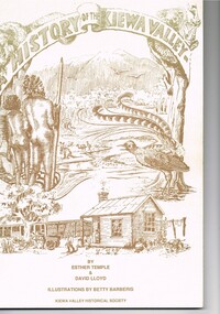
Book - A History of the Kiewa Valley, Kiewa Valley Historical Society, A History of the Kiewa Valley by Esther Temple and David Lloyd, Circa 1991
This book was compiled by Esther Temple and David Lloyd with illustrations by Betty Barberis and additional material provided by Clare Roper, Joan Macdonald, Wilma Davies and Nell Bateman. The book was first penned in 1971. It briefly covers the period from the indigenous tribes(broken down into family groupings) known as the "first Australians" who lived in the valley well before English settlers arrived. first white settlement (graziers, miners, stockmen) to smaller settlements.The development or transformation from a pristine(hunter/gatherer) valley environment to one that has been gradually changing to a more commercial rural/industrial landscaped valley. This transformation was made within a time span of two hundred years. The book details the first pioneers and their descendants, along with the changes to their environments both domestic and commercial. The book highlights dates and events that shaped the "feel" of the valley. The extreme hardships faced by pioneer families during the extremely isolated times away from "civilisation".This publication provides an insight to the struggles and victories against the harsh Australian bushland by people who had not been raised in such a sometimes inhospitable environment. It was this transformation which instilled into the Australian psyche of self sufficiency and the ability to grasp onto ideas or "bush" remedies to overcome enormous difficulties. It is is ability that has produced the many inventions useful in the 20th and 21st centuries.This book has a 250 g/m cream coloured cover with print and drawings of rural aspects of historical significance ( Aboriginal and early white settlers). The book contains 124 pages of black and white photographs(139), black and white sketches(75), two pages of sketches and freehand drawings, two freehand maps one county lease /subdivision plan and black and white printing. See KVHS 0237 (B) for the official invitation to the launch of the book.The front top cover heading(in shaded print and enclosed in a banner form) "A HISTORY OF THE KIEWA VALLEY" The bottom printing "BY ESTHER TEMPLE & DAVID LLOYD ILLUSTRATIONS BY BETTY BARBERIS" and at the very bottom "KIEWA VALLEY HISTORICAL SOCIETY" oN THE BOOK SPINE "A HISTORY OF THE KIEWA VALLEY.....BY ESTHER TEMPLE & DAVID LLOYD"early settlers, dederang, tawonga, mount beauty, sec vic hydro electricity, falls creek early settlers, bonegilla -
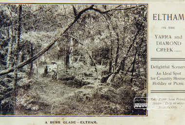 Eltham District Historical Society Inc
Photograph, A bush glade Eltham, c.1909, 1909c
Colour photograph from land sales brochure showing a bush glade Eltham c1909 sent to Mrs Andrewbush glade, eltham, bushland -
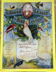
 Orbost & District Historical Society
certificate, Stockland Press Pty Ltd, mid 20th century
Named to honour the work of John and Elizabeth Gould, 'The Gould League of Bird Lovers' was formed in 1909. It was originally set up to prevent bird egg collecting and to educate for the protection of Australian birds. Gould League members were recruited via schools and received membership certificates and badges. Members were encouraged to enter competitions in bird mimicry, write stories and poems and attend 'bird-day concerts'. This certificate belonged to Patricia Legge. Ruth Scott, daughter of Herbert Scott and Bertha (nee Coverdale), married David Legge. Patricia Dawn Legge and Kevin David Legge are Ruth and David's children. The Gould League has made a significant impact on generations of Australians and their environmental attitudes. Being a Gould league member as a child in primary school gave children the opportunity to belong to a group that was learning about and protecting native bushland and its wildlife. Although not operating some Australian states the Gould League continues in Victoria.A Gould League of Bird Lovers of Victoria membership certificate for Patricia Dawn Legge 1959. It has colourful illustrations of native Australian birds on a pale yellow background. The illustrations are by A.T. Mockridge, an early 20th century Melbourne commercial artist and portraitist. In a banner at the top is a photo of John Gould with GOULD LEAGUE of BIRD LOVERS around it. It has a list of patrons, presidents and the Central Council. There is also the Bird Lover's Pledge unsigned in the middle.In pen - Patricia Dawn Legge 1959certificate gould-league -
 Orbost & District Historical Society
certificate, Stockland Press Pty Ltd, mid 20th century
Named to honour the work of John and Elizabeth Gould, 'The Gould League of Bird Lovers' was formed in 1909. It was originally set up to prevent bird egg collecting and to educate for the protection of Australian birds. Gould League members were recruited via schools and received membership certificates and badges. Members were encouraged to enter competitions in bird mimicry, write stories and poems and attend 'bird-day concerts'. This certificate belonged to Kevin Legge. The Gould League has made a significant impact on generations of Australians and their environmental attitudes. Being a Gould league member as a child in primary school gave children the opportunity to belong to a group that was learning about and protecting native bushland and its wildlife. Although not operating some Australian states the Gould League still functions in Victoria.A Gould League of Bird Lovers of Victoria membership certificate for Kevin Legge. It has colourful illustrations of native Australian birds on a pale yellow background. The illustrations are by A.T. Mockridge, an early 20th century Melbourne commercial artist and portraitist. In a banner at the top is a photo of John Gould with GOULD LEAGUE of BIRD LOVERS around it. It has a list of patrons, presidents and the Central Council. In the middle there is also the Bird Lover's Pledge signed by Kevin Legge . Ruth Scott, daughter of Herbert Scott and Bertha (nee Coverdale), married David Legge. Patricia Dawn Legge and Kevin David Legge are Ruth and David's children. Kevin was born in 1958.The pledge has been signed by Kevin Legge. -
 Orbost & District Historical Society
certificate, Stockland Press Pty Ltd, 1930's
Named to honour the work of John and Elizabeth Gould, 'The Gould League of Bird Lovers' was formed in 1909. It was originally set up to prevent bird egg collecting and to educate for the protection of Australian birds. Gould League members were recruited via schools and received membership certificates and badges. Members were encouraged to enter competitions in bird mimicry, write stories and poems and attend 'bird-day concerts'. This certificate was owned to Ruth Scott of Nicholson Street Orbost when she was 10 years old. She was a member of the Gould League for 61 years. Ruth Scott, daughter of Herbert Scott and Bertha (nee Coverdale), married David Legge. Patricia Dawn Legge and Kevin David Legge are Ruth and David's children. There are Gould League certificates for both children in the collection.The Gould League has made a significant impact on generations of Australians and their environmental attitudes. Being a Gould league member as a child in primary school gave children the opportunity to belong to a group that was learning about and protecting native bushland and its wildlife. Although not operating some Australian states the Gould League still functions in Victoria.A Gould League of Bird Lovers of Victoria membership certificate for Ruth Scott. It has colourful illustrations of native Australian birds on a pale yellow background. The illustrations are by A.T. Mockridge, an early 20th century Melbourne commercial artist and portraitist. In a banner at the top is a photo of John Gould with GOULD LEAGUE of BIRD LOVERS around it. It has a list of patrons, presidents and the Central Council. In the middle there is also the Bird Lover's Pledge signed by Ruth Scott..The pledge has been signed by Ruth Scott.certificate gould-league -
 Eltham District Historical Society Inc
Photograph, Creek crossing, Long Gully Bushland Reserve, Panton Hill, 6 December 1992, 06/12/1992
The Eltham Horse Trail: Research and Warrandyte to Kinglake: Survey of proposed route, December 1992: (3) Kangaroo Ground to KinglakeColour photographeltham horse trail (1992 survey), panton hill, long gully road -
 Eltham District Historical Society Inc
Photograph, Happy Valley bushland from Rob Roy Road, Panton Hill, 6 December 1992, 06/12/1992
The Eltham Horse Trail: Research and Warrandyte to Kinglake: Survey of proposed route, December 1992: (3) Kangaroo Ground to KinglakeColour photographeltham horse trail (1992 survey), panton hill, rob roy road, happy valley -
 Glen Eira Historical Society
Letter - MEMORIES GLEN EIRA ROAD
2 items: 1/A ten page handwritten letter from Mrs. C.R. Biesse on 12/12/1976 to Mr. Murray. The letter gives her memories of the area around Judge Hood’s Estate, related to her by an elderly acquaintance and her grandfather. Includes a small handdrawn map. 2/Handwritten research by Claire Barton on street names and residents off Orrong Road in 1911 Sands and McDougall directory.biesse c.r. mrs., merton street, caulfiled north, judge hood, hood crescent, droving, judge hood’s estate, land subdivision, judge stephens, st. mary’s church, otira road, helenslea road, shelford, landscapes, kerr b. mrs., palmer florence mrs., morrice street, glen eira road, kambea grove, bushland, cattle, mitchell mr. builder, palmer florence, mitchell colin, mitchell clive, mitchell francis, mitchell mrs., perry family, orrong road, st. aubins ave., ‘orotava’, hayes g.h., ‘kambea’, lothian henry, oswald j.d., ‘merton’, glen eira road -
Whitehorse Historical Society Inc.
Article, A Bushland valley reclaimed
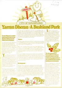
Article talking about the beginnings of Yarran Dheran, once used as a stone quarry and then a council tip. Nunawading Council and Blackburn & District Tree Preservation Society and local residents drew up plans to protect and restore what was left and create and reconstruct the rest of the bush gully.parks and reserves, yarran dheran, schwerkolt cottage, schwerkolt, albert, city of nunawading, blackburn and district tree preservation society -
Whitehorse Historical Society Inc.
Document, Bushland Reserves Fire Management Strategy, 2010
City of Whitehorse Strategy to assess the risk of bushfire and consider any necessary responses, Oct 2010.City of Whitehorse Strategy to assess the risk of bushfire and consider any necessary responses, Oct 2010.City of Whitehorse Strategy to assess the risk of bushfire and consider any necessary responses, Oct 2010.bushfires, bushland -
 Whitehorse Historical Society Inc.
Pamphlet, Yarran Dheran: a bushland park, 1/10/1982
Pamphlet explaining the history and development of Yarran Dheran. A map is included and features and attractions including Schwerkolt Cottage.bushland, yarran dheran, mullum mullum creek, city of nunawading, schwerkolt, johann august, quarries -
 Whitehorse Historical Society Inc.
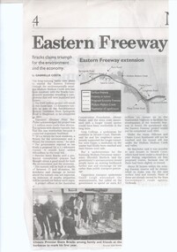
Article, Eastern Freeway To Be Tunnelled, 2000
The Eastern freeway will be tunnelled under the Mullum Mullum Creek.The Eastern freeway will be tunnelled under the Mullum Mullum Creek.The Eastern freeway will be tunnelled under the Mullum Mullum Creek.eastern freeway extension, tunnels, mullum mullum valley, freeways, bushland, koonung mullum forestway association -
 Ballarat Heritage Services
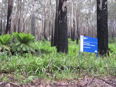
Photograph - Colour, Clare Gervasoni, Bushland Around O'Shannassy water Supply Catchment, 2012, 16/12/2012
Colour photographs of bush around Marysville showing signs of regrowth after the "Black Saturday' Bushfire.bushfire, black saturday, marysville, regrowth, o'shannassy water supply catchment -
 Bayside Gallery - Bayside City Council Art & Heritage Collection
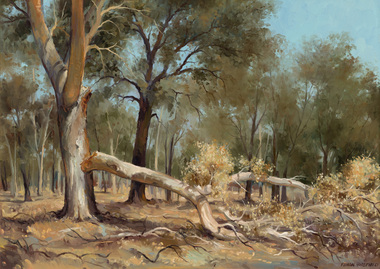
Painting - oil on canvas on board, Ramon Horsfield, Murray River bushland
ramon horsfield, country, rural, landscape, bush, gum, tree, murray river -
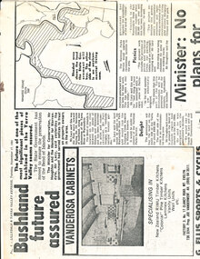 Wonga Park Community Cottage History Group
Work on paper - Newspaper cutting, Wonga Park: 17 Nov 1981 Lillydale and Yarra Valley Express: "Bushland future assured" re Acquisition of Yarra River frontage for State Park
-
 Tarnagulla History Archive
Photograph: Bushland on mullock heaps in Tarnagulla
David Gordon Collection. -
Canterbury History Group
Photograph - Weymouth family on picnic to Warrandyte
Black and white photograph of the Weymouth family on a picnic to Warrandyte using the horse from the hardware shop in Canterburycanterbury, warrandyte, weymouth family, horses, horse drawn vehicles, picnics, bushland -
Canterbury History Group
Photograph - Weymouth Family on picnic to Warrandyte
Black and white photograph of Weymouth family on the way to a picnic in Warrandyte with the horse and cart from the hardware shop in Canterburycanterbury, warrandyte, weymouth family, horses, horse drawn vehicles, picnics, bushland, roads and streets -
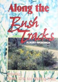 Wodonga & District Historical Society Inc
Book - Along the Bush Tracks, Albury-Wodonga, Monument Hill Parklands, 1997
A detailed history and description of the hilltop bushlands of Albury-Wodonga, including plants, birds and trails. This publication was originally written by members of Monument Hill Parklands and Albury Wodonga Field Naturalists with support from the National Environment Centre (Riverina Institute of TAFE) and Parklands Albury Wodonga.non-fictionA detailed history and description of the hilltop bushlands of Albury-Wodonga, including plants, birds and trails. This publication was originally written by members of Monument Hill Parklands and Albury Wodonga Field Naturalists with support from the National Environment Centre (Riverina Institute of TAFE) and Parklands Albury Wodonga.parklands albury wodonga, bush tracks, bushland albury wodonga -
Healesville Sanctuary Heritage Centre
Newspaper - Cutting, Endacott, Frank, Sanctuary at Healesville, 17 March 1963
Sanctuary escapes fire which hit Coranderrk bushlands but writer states Sanctuary authorities have failed to put in place preventative want the council to close public road which gives access for firefighters; by Frank Endacott.original x 1 photocopy x 1non-fictionSanctuary escapes fire which hit Coranderrk bushlands but writer states Sanctuary authorities have failed to put in place preventative want the council to close public road which gives access for firefighters; by Frank Endacott.1960s -
 Linton and District Historical Society Inc
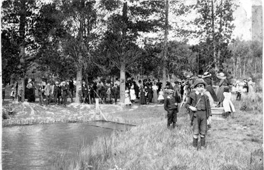
Photograph, Postcard : group of people on bushland outing, c.1911
Postcard given to Stella Todd by Linton State School head teacher Mr H. B. Williamson, wishing her a happy year in 1912.Black and white postcard photograph of men, women and children, thought to be a Linton State School group, on an outing in rural setting (possibly Mortchup Road reservoir)."To Stella Todd with best wishes for the new year 1912 from her teacher H B Williamson".stella todd, stella surman, linton state school no. 880, h. b. williamson [head teacher], picnics -
 Ringwood and District Historical Society
Photograph, Maroondah Highway East, Ringwood- 1969. Bushland at top end of RingwoodLake
Black and white photograph -
 Bendigo Historical Society Inc.
Newspaper - Article about a mystery sign found in Bendigo bushland, Wed May 27 2020
Terry Davidson found the star in plain sight in the Diamond Hill historical area near Kangaroo Flat, Golden Square and Spring Gully.Bendigo Advertiser: Story entitled 'Help Solve this History Mystery', about a star-shaped metal sign. bendigo mystery star, terry davidson