Showing 12753 items
matching estates
-
 National Wool Museum
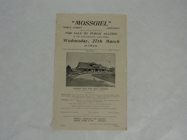
Notice, Mossgiel
From a family who had three generations that worked for Dennys Lascelles. This notice is advertising the upcoming auction of Mossgiel estate through the Dennys Lascelles Company. The auction would take place at The Wool Exchange. Mossgiel was built for and owned by Brigadier-General Robert Smith who (I believe) foundered the Returned Soldiers & Sailors Mill in Newtown.Single paper page, off-white colour with black text and black and white photograph. Upper part of text describes the auction details, there is a photo in the centre of the page. Text below the photo describes the estate details and auction terms. -
 Bacchus Marsh & District Historical Society
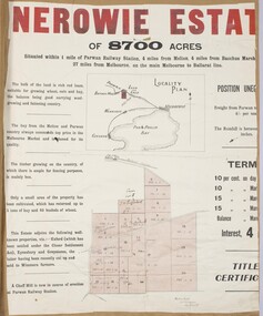
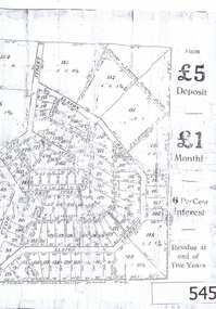
Map, Nerowie Estate Land Sale 1910
The Nerowie Estate was a large rural property of 8,700 acres (3520 hectares) near the locality of Parwan only a few kilometers east of Bacchus Marsh. It had once formed a large part of the land owned by the pioneering Staughton family.A single page paper map showing the land offered for sale from the Nerowie Estate at Parwan near Bacchus Marsh in 1910. The map is pasted into a bound volume containing 76 maps or plans in total. High resolution digital image stored on BMDHS computer network. nerowie estate parwan, land sales parwan, land sales bacchus marsh, staughton family bacchus marsh -
 Warrnambool and District Historical Society Inc.
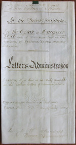
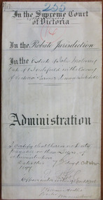
Document - Margaret Lord Letters of Administration 1890, 1896
This is an 1896 document containing the Letters of Administration following the death of Margaret Lord, a widow from Warrnambool. She died intestate in April 1896 and left real estate to the value of £15 and personal estate to the value of £250. The estate was to be administered by her son, John Lord, a draper from Warrnambool. Tait collection: item 13 of 62This document is of interest because it concerns a local Warrnambool woman, Margaret Lord and a local lawyer, Ernest Chambers The latter had offices in Warrnambool with the known dates 1896 to 1910, with other offices in Koroit and Port Fairy during the same period. His manager in Warrnambool was Thomas Goodall and this document with others was passed to lawyers occupying the same premises in Kepler Street and it was found in the buildings previously occupied by the legal firm Mackay Taylor.This is a piece of parchment paper folded in two with writing in brown-coloured ink on the back and front of the document. It has a seal of the Supreme Court of the Colony of Victoria and one red stamp of the Master in Equity of the Supreme Court. The writing is somewhat faded but still legible.‘In the Supreme Court of the Colony of Victoria, In the Probate Jurisdiction in the Estate of Margaret Lord, Late of Warrnambool in the Colony of Victoria, Widow, deceased, intestate, Letters of Administration. I certify that there is no duty payable on the within Letters of Administration, J. Poole, Officer Under Section 96 Act 1060, Dated the 22nd day of July 1896. E.J.W. Chambers, Proctor, Warrnambool’ margaret lord, ernest chambers, warrnambool -
 Greensborough Historical Society
Advertising Leaflet, 21 Doris Street Greensborough, 05/05/2018
4 bedroom brick veneer home, auctioned 5 May 2018, sold for $960,000Real estate advertising leaflet, 1 sheet, colour.doris street greensborough -
 Greensborough Historical Society
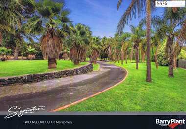
Advertising leaflet, 3 Marino Way Greensborough, 30/11/2012
3 Marino Way Greensborough, 6 bedroom 2 storey home on 4215 sq m allotment, auctioned on 30 November 2012, sold for $1,580,000. Property has since been subdivided into 7 allotments4 page colour real estate advertising leafletmarino way greensborough -
 Greensborough Historical Society
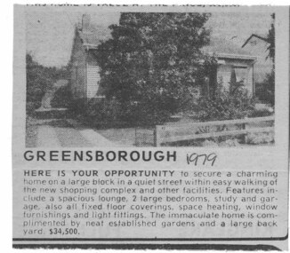
Advertisement - Digital image, 23 Mayfield Street Greensborough,1979, 1979_
This 1979 advertisement is for the sale of a house at 23 Mayfield Street Greensborough. Contains description and price of house.Digital copy of black and white real estate advertisement.Date handwritten on page.mayfield street -
 Greensborough Historical Society
Advertisement, Greenhills Estate, 1923c
The advertisement was used to sell land in the Greenhills area.The plan included details the original street lay out and names applied to them. It also has dimensions of all the blocks of land available and locations and dimensions of easements.A 2 page A3 photoccopy of a real estate advertisement. Nilgreehills, subdivision plan, greensborough -
 Greensborough Historical Society
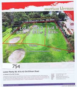
Advertisement, Fairfax Media, Lower Plenty 38, 40 & 42 Old Eltham Road, 22/08/2012
This advert appear in the Weekly Review on 22/08/2012.It features the sale of 38, 40 & 42 Old Eltham Rd, Lower Plenty in 2012. Land borders Heidelberg Golf Club.A 1 page multi coloured Real Estate advertisement.Nillower plenty, morrison kleeman, old eltham road -
 Ringwood and District Historical Society
Envelope, Estate Agents - various plans and notes of Ringwood Subdivision
Estate Agents - various plans of Subdivision; Notes on Subdivisions -
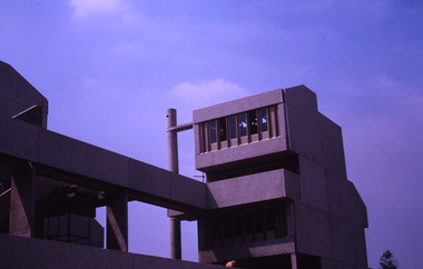
 Robin Boyd Foundation
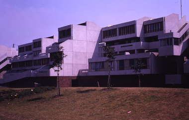
Slide, Robin Boyd, 1969
Robin Boyd travelled to the USA and Britain for several weeks. He attended the opening of the new Australian Chancery in Washington DC, where he had designed an innovative exhibition with cylindrical display cases and sound recordings.Colour slide in a mount. Thamesmead Estate, London, EnglandMade in Australia / 8 / JUL 69M2slide, robin boyd -
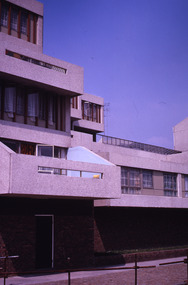
 Robin Boyd Foundation
Slide, Robin Boyd, 1969
Robin Boyd travelled to the USA and Britain for several weeks. He attended the opening of the new Australian Chancery in Washington DC, where he had designed an innovative exhibition with cylindrical display cases and sound recordings.Colour slide in a mount. Thamesmead Estate, London, EnglandMade in Australia / 6 / JUL 69M2slide, robin boyd -
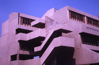
 Robin Boyd Foundation
Slide, Robin Boyd, 1969
Robin Boyd travelled to the USA and Britain for several weeks. He attended the opening of the new Australian Chancery in Washington DC, where he had designed an innovative exhibition with cylindrical display cases and sound recordings.Colour slide in a mount. Thamesmead Estate, London, EnglandMade in Australia / 4 / JUL 69M2slide, robin boyd -
 Robin Boyd Foundation
Slide, Robin Boyd, 1969
Robin Boyd travelled to the USA and Britain for several weeks. He attended the opening of the new Australian Chancery in Washington DC, where he had designed an innovative exhibition with cylindrical display cases and sound recordings.Colour slide in a mount. Thamesmead Estate, London, EnglandMade in Australia / 12 / JUL 69M2slide, robin boyd -
 Robin Boyd Foundation
Slide, Robin Boyd, 1969
Robin Boyd travelled to the USA and Britain for several weeks. He attended the opening of the new Australian Chancery in Washington DC, where he had designed an innovative exhibition with cylindrical display cases and sound recordings.Colour slide in a mount. Thamesmead Estate, London, EnglandMade in Australia / 5 / JUL 69M2slide, robin boyd -
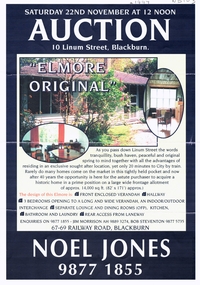 Whitehorse Historical Society Inc.
Document, 'Elmore' original, 1/10/1997 12:00:00 AM
Estate Agent's advertisementEstate Agent's advertisement for No 10 Linum Street BlackburnEstate Agent's advertisementelmore houses, linum street, blackburn, no 10 -
 Whitehorse Historical Society Inc.
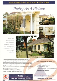
Document, 20 Rosstrevor Crescent, 1/10/1997 12:00:00 AM
Estate agent's advertisement for No 20 Rosstrevor Crescent, Mitchamrosstrevor crescent, mitcham, no 20 -
 Whitehorse Historical Society Inc.
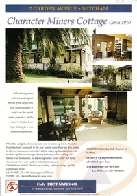
Document, Miners Cottage, 1/10/1997 12:00:00 AM
Estate agent's advertisement fEstate agent's advertisement for No 7 Garden Avenue, MitchamEstate agent's advertisement fgarden avenue, mitcham, no 7 -
 Whitehorse Historical Society Inc.
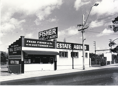
Photograph - Black and white photograph, Fisher Real Estate Agents, 1977
Black and white photo of Fisher Real Estate officesfrank fisher & co., real estate agent, blackburn -
 Robin Boyd Foundation
Slide, Robin Boyd, 1969
Robin Boyd travelled to the USA and Britain for several weeks. He attended the opening of the new Australian Chancery in Washington DC, where he had designed an innovative exhibition with cylindrical display cases and sound recordings.Colour slide in a mount. Thamesmead Estate, London, EnglandMade in Australia / 1 / JUN 69M2slide, robin boyd -
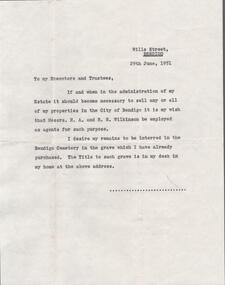 Bendigo Historical Society Inc.
Document - EDWIN BUCKLAND COLLECTION: EXECUTORS AND TRUSTEES, 29/06/1951
Document. Letter of instructions to the Executors and Trustees of my Estate. -
 Port Fairy Historical Society Museum and Archives
Photograph, Jock Varcoe
South Beach DevelopmentColoured photograph of Road building on South Beach Estatesouth beach, development, road, street, building -
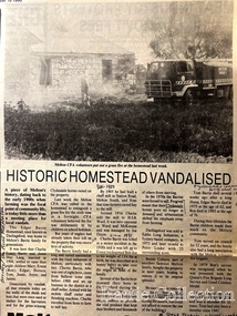 Melton City Libraries
Newspaper, Historic Homestead Vandalised, 1990
Edna Barrie describes the Darlingsford property. C.E. Barrrie Land developers bought the property from my husband’s brother. It was one big farm and they were a big family. When the father died he left it to be cut up for the family. The youngest son had to reach age 21 before the property could be divided and portioned out to the mother and children, but it was deferred until Jim returned from the war. Eventually it was cut up into two parts, we were married by then and so was Edgar. Part of the land included the block on the other side of Ferris road, which became the quarry, Edgar’s section was on the Toolern Creek end, he was the last one married and lived in the old bluestone house until 1974. The developers bought this section but they could not get permits due to the state of the old bridge due to the cost. Barries had built the bridge across the creek [1926]. It took the big loads of hay and the family kept it maintained. Once the Barries had gone it did not get any upkeep. The developers found the cost of replacing the bridge and developing site with sewerage and drainage power before they sell. The rural land itself is not worth much as the developer has to complete the subdivision before any blocks can be sold. The developer from Sydney had a man living in the house, who let it go the rack and ruin. He managed to buy from the developer 25 acres with the bluestone house. Bernard Coburn had it for a while but is was well out of our hands by then. There were various people who have bought into and tried to develop and have given up. There was a project sometime ago to save the buildings from ruin but nothing has happened as yet, they are six or seven years to late. The buildings continue to deteriorate and were badly damaged vandals and fire. The Shire bought all the rest of it from the developer, where the tip is now, that was also part of Edgars land. Article about a fire at Darlingsford Estate featured in the Telegraphlocal architecture, local identities, emergency services -
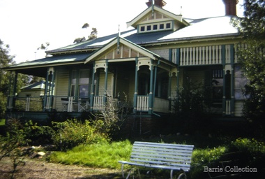 Melton City Libraries
Photograph, "Green Hills" Borbidge, 1978
Built by Water Browne c.1903 Greenhills was one of the first pastoral runs, and centres of European settlement, established in the Shire of Melton. Estate in Diggers Rest Coimadai Road, Toolern Valelocal architecture, pioneer families -
 Marysville & District Historical Society
Ephemera (item) - Real Estate advertisement, RT Edgar, Unknown
-
Stawell Historical Society Inc
Memorabilia - Realia, Health Care Wallet
Health Care Wallet from Estate of Jill Gammonstawell, medical -
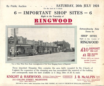 Ringwood and District Historical Society
Flyer, Shop Sites Sale By Public Auction, Ringwood, Victoria - 1924
Folded double-sided brochure advertising six Ringwood shop sites for sale by Public Auction at 3pm, Saturday, July, 1924, with town photographs, location map, and summary of local features and services. Includes newspaper extract from the Real Estate and Property section from "Evening Sun", 6th June, 1924.Locality plan highlights shop sites for auction east of Pratt Street along Whitehorse Road. (Agents) Knight & Harwood, 315 Collins Street, Melbourne, Phones 10615, 10616 Central, in conjunction with J.B. McAlpin, Estate Agent, Opposite Railway Station, Ringwood, Phone Ringwood 7. -
 Warrnambool and District Historical Society Inc.
Document - John Moloney Letters of Administration 1897, 1897
Tait collection: item 43 of 62 This is a document giving details of the Letters of Administration of John Moloney, a farmer from Bushfield, who died in July 1897. He died intestate but had real estate to the value of £510 and personal estate to the value of £142. The beneficiary was his wife, Mary Ann Moloney. The lawyer involved in drawing up this document was William Ardlie, one of the best-known lawyers in Warrnambool in the 19th and 20th centuries. He commenced his business in the 1860s and continued on until the 1930s when he was well in his eighties, making him at the time the oldest practising lawyer in Australasia. The document seemed to have been passed down by successive lawyers occupying the Kepler Street legal premises and located there in 2014.This document is of some interest as it gives details of the Letters of Administration of John Moloney, a 19th century farmer from Bushfield and it also concerns the lawyer, William Ardlie, a prominent Warrnambool lawyer at that time. It will be useful for researchers.This is a piece of cream-coloured thin parchment paper folded in two. It has handwritten material on two pages (black ink) containing details of the Letters of Administration following the death of John Moloney of Bushfield in 1897. A seal of the Supreme Court of Victoria is attached with green ribbon and there is one red stamp of the Master in Equity of the Supreme Court. The document is somewhat dirty but quite legible. The numbers ‘255’ and ‘14’ are written in blue pencil on the back page. In the Supreme Court of the Colony of Victoria In the Probate Jurisdiction In the Estate of John Moloney late of Bushfield in the Colony of Victoria Farmer deceased Intestatejohn moloney, warrnambool, william ardlie, bushfield, tait collection -
 Phillip Island and District Historical Society Inc.
Newspaper clippings
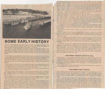
Album donated by Miss Edith Elms via Chrisy Northcote. Details from 1758 visit by Bass, Wattle Bark export in 1833, opening of surrounding district with pioneering families, Estate Agent, John Keam & Co and the installation of Postal services in 1873 (brief history of San Remo 1798 - 1928)Two clippings with sub-headings "some early history" - San Remo Heights Estate Hall and San Remo Post Office. Photo of San Remo Port with fishing, boat middle, at top of article large sub-heading "San Remo"Titled San Remolocal history, documents, newspapers, san remo, local area development by europeans, newspapers san remo -
 Kew Historical Society Inc
Plan - Subdivision Plan, Raheen Estate Subdivision, 1960
Subdivision plans are historically important documents used as evidence of the growth of suburbs in Australia. They frequently provide information about when the land was sold on which a built structure was subsequently constructed as well as evidence relating to surveyors and real estate and financial agents. The numerous subdivision plans in the Kew Historical Society's collection represent working documents, ranging from the initial sketches made in planning a subdivision to printed plans on which auctioneers or agents listed the prices for which individual lots were sold. In a number of cases, the reverse of a subdivision plan in the collection includes a photograph of a house that was also for sale by the agent. These photographs provide significant heritage information relating house design and decoration, fencing and household gardens.The Raheen Estate Subdivision of 1960 involved the creation of 36 residential allotments and the sale of 34 of these. The land on which the subdivision was created had until 1960 formed part of the grounds of the mansion Raheen in Studley Park Road. In 1917, the Catholic Church had purchased Raheen and its lands. It was to become the home of Archbishop of Melbourne, Daniel Mannix, for 46 years. The sale of the subdivision took place three years before the Archbishop’s death. Subsequent archbishops were to reside at Raheen until its sale to the Pratt family in 1981. When the sale of the Estate was reported in the newspapers in 1960, it was described as the last big subdivision near Melbourne. At the auction, 33 of the 36 allotments were sold. The auction realised £315,750. Purchasers were advised that the vendor intended to keep lots 22 and 23. The alllotments in the subdivision required the construction of new roads. These included Eamon Court and Raheen Drive. The justification provided by the Church for the sale was that the estate was being sold to finance school building projects.subdivision plans - kew, studley park, raheen estate, eamon court, studley park road, coombes avenue, raheen drive -
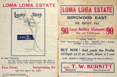 Ringwood and District Historical Society
Flyer, Land Sale Brochure, Loma Loma Estate, Ringwood East, Vic. - circa 1924
Flyer includes extract from "The Sun" 30/10/1924. "Ringwood has been created a Borough with capital value of £680,000. In 1908 there were 173 houses, 8 shops and 720 people. In 1918 the respective figures were 520, 45 and 2,080. For twelve months ended June, 1924, £51,000 worth of Home Sites were sold and £26,000 worth of new buildings were erected. Outward (train) passenger journeys have increased from 94,000 in 1919 to 182,000 in 1923. Train services have been almost doubled and time to Melbourne reduced from 60 to 37 minutes."Bi-fold double-sided land sale advertisement for Loma Loma Estate, Ringwood East, including area map, layout of the estate, and summary of local facilities and services.Subdivision includes Loma Street, Highton Street, Morinda Street, and Station Street (later Railway Avenue) Ringwood East. Agent: T.W. Burkitt, Ringwood, Phone Ringwood 157.